Mori Atlas logo
Protected areaWzgórza Kunowskie

Discover the complex mosaic of dunes, riparian forests, and xerothermic meadows in this Polish protected landscape

Wzgórza Kunowskie Protected Area: A Comprehensive Atlas of Habitat and Geographic Diversity in Świętokrzyskie

(Specjalny obszar ochrony siedlisk Wzgórza Kunowskie (PLH260039))

Wzgórza Kunowskie represents a significant protected area within Poland's Świętokrzyskie Voivodeship, recognized internationally for its concentration of diverse habitat types. The site provides a critical look at the interaction between dry inland dunes, warm xerothermic grasslands, and moist riparian floodplains along a river valley. Through structured geographic mapping, this record details the structural landscape where sandy uplands transition into fertile riverine corridors, supporting a rare suite of Central European ecosystems.

Natura 2000Special Area of Conservationhabitat protectioninland dunessand grasslandsxerothermic grasslands

Wzgórza Kunowskie

Protected area

Park overview

Structured park overview, official facts, and landscape profile for Wzgórza Kunowskie

Wzgórza Kunowskie park facts, protected area profile, and essential visitor context

Review the core facts for Wzgórza Kunowskie, including designation, size, terrain, visitor scale, habitats, and operating context in one park-focused overview.

About Wzgórza Kunowskie

Wzgórza Kunowskie is one of numerous Polish Special Areas of Conservation that contribute to the Natura 2000 ecological network and is identified by the site code PLH260039. The area is located in the Świętokrzyskie Voivodeship in south-central Poland, a region historically marked by a mix of sandy uplands, loess slopes, and river valleys draining toward the Vistula basin. The 1,869-hectare site captures a particularly representative cross-section of those landscape elements, with habitats that range from open, dry sand grasslands to closed, moisture-loving floodplain forests.

At the heart of the site's identity is its habitat diversity. Inland dunes with accompanying sand grassland communities, classified under habitat 2330, occupy the drier parts of the area and provide conditions for specialized psammophilous vegetation. On warmer, sun-exposed slopes and hilltops, xerothermic dry grasslands of the Festuco-Brometea type and related Asplenion communities thrive, harboring plants and invertebrates adapted to drought-prone, calcareous or base-rich soils. These dry habitats are bordered and intersected by river valleys where the environment shifts.

Along the valley floor, the area preserves relict oxbow lakes and natural eutrophic water bodies of the Nympheion and Potamion type, surrounded by wet meadows such as the Molinia-dominated grasslands of the Molinion alliance and extensive, traditionally mown Arrhenatherion hay meadows. These open valley habitats create the open, half-open landscape structure that many species require and connect to the forest habitats that give the site its wooded character. The forests include Central European and subcontinental Galio-Carpinetum and Tilio-Carpinetum oak-hornbeam stands on more stable soils, together with riparian woodlands: Salicetum albo-fragilis and Populetum albae communities along the main channel, Alnenion glutinoso-incanae alder-ash forests on moving groundwater slopes, and Ficario-Ulmetum oak-elm-ash floodplain forests on periodically flooded lowlands.

The collective importance of the site lies in its representation of Central European landscape transitions: from dry sandy upland through thermophilic slope communities to riverine floodplain and freshwater systems. By safeguarding this gradient within a single managed area, Wzgórza Kunowskie plays a role in conserving habitat types that are reduced or fragmented elsewhere in Poland and across the European Union, and it provides a benchmark for research, monitoring, and habitat management under the Habitats Directive.

Quick facts and research context for Wzgórza Kunowskie

Wzgórza Kunowskie is a Polish Natura 2000 site coded as PLH260039 and classified as a Special Area of Conservation focused on the protection of natural habitat types. It lies in the Świętokrzyskie Voivodeship and occupies approximately 1,869 hectares near coordinates around 50.98°N, 21.27°E.

The site protects nine habitat types listed under the European Habitats Directive, spanning inland dunes with sand grasslands, xerothermic dry grasslands, Molinia meadows, extensive hay meadows, Central European oak-hornbeam forests, riparian willow-poplar-alder-ash forests, and floodplain oak-elm-ash forests. Several of these habitats depend on continuing traditional land management, particularly extensive mowing and grazing, as well as on natural river dynamics that maintain old river channels and nutrient-rich water bodies.

Protection and recognition

Examine official designation records and international conservation frameworks for Wzgórza Kunowskie.

Wzgórza Kunowskie Protection Status and Natura 2000 Recognition

Wzgórza Kunowskie preserves a documented conservation framework centered on verified Natura 2000 recognition sources. Detailed protection status records outline international designation standards and administrative parameters for the protected area.
Park context

Deeper park guide and search-rich context for Wzgórza Kunowskie

Wzgórza Kunowskie history, landscape, wildlife, and travel context

Explore Wzgórza Kunowskie through its history, landscape character, ecosystems, wildlife, conservation priorities, cultural context, and seasonal travel timing in a structured park guide built for atlas discovery and search intent.

Why Wzgórza Kunowskie stands out

Wzgórza Kunowskie is best known for its unusually rich concentration of protected habitat types within a single Natura 2000 site, particularly the juxtaposition of inland dunes with sand grasslands, dry xerothermic swards, and a full suite of floodplain forests along a river valley. The site illustrates how sandy uplands and moist valley floors can support contrasts of dry and humid habitats in close proximity, while old river arms and natural eutrophic water bodies add a further aquatic dimension. The protected habitats include dune grasslands such as those with Corynephorus and Agrostis, xerothermic grasslands of the Festuco-Brometea and Asplenion septentrionalis groups, trembling grasslands of the Molinion alliance, extensively used Arrhenatherion meadows, Central European and subcontinental oak-hornbeam forests, and willow-poplar as well as alder-ash riparian forests. Together these communities represent the characteristic habitat mosaic of the Świętokrzyskie region's transition between sandy uplands and riverine lowlands.

Wzgórza Kunowskie landscape and geographic character

The landscape of Wzgórza Kunowskie is defined by a clear physical gradient from sandy uplands down to a river valley. The higher, drier parts of the area feature inland dunes, locally overlain by sand grasslands, that give way to warm, often south-facing slopes supporting xerothermic vegetation. The valley floor, by contrast, is shaped by a watercourse and its former channels, with slow-moving sections, old river arms, and naturally eutrophic pools that contrast sharply with the dry surroundings.

Between these two extremes lie transitional slopes and terraces where soils shift from sandy and well-drained to moister, sometimes seasonally flooded substrates. This mosaic of landforms supports a layered scenery: open, sun-exposed dunes and dry grasslands at the top; wooded hill-slopes and oak-hornbeam forests on mid-slopes; and, along the valley, riparian woodlands, low meadows, oxbows, and wet depressions. The combination of dry and humid features in such close proximity gives the area much of its visual and ecological character.

Wzgórza Kunowskie ecosystems, habitats, and plant life

Ecologically, Wzgórza Kunowskie stands out for the breadth of habitat types it preserves within a relatively compact area. The site is officially designated for nine habitat types listed under the European Habitats Directive, covering dry, mesic, wet, aquatic, and woodland communities. This range allows species specialized in very different conditions to persist side by side, and it gives the area an unusually high habitat-to-area ratio for the Świętokrzyskie region.

The dry end of the gradient is represented by inland dunes with Corynephorus and Agrostis sand grasslands and by xerothermic swards of the Festuco-Brometea class with Asplenion septentrionalis elements, which typically host drought-adapted vascular plants and characteristic invertebrates. The mid-slope and plateau vegetation includes Central European and subcontinental Galio-Carpinetum and Tilio-Carpinetum oak-hornbeam forests, which form the wooded backbone of the area and provide habitat continuity with surrounding landscapes.

On the valley floor, the nature of the site shifts decisively toward moisture-dependent communities. Old river arms and naturally eutrophic water bodies with Nympheion and Potamion vegetation introduce aquatic and amphibious habitats, while Molinion grasslands and extensive Arrhenatherion meadows provide open, herb-rich conditions that depend on continued traditional management. Along channels and wet depressions, the site hosts willow-poplar, alder-ash, and oak-elm-ash floodplain forests of the Salicetum albo-fragilis, Populetum albae, Alnenion glutinoso-incanae, and Ficario-Ulmetum types, completing a near-continuous series of natural and semi-natural habitats from dry sand to standing water.

Wzgórza Kunowskie conservation status and protection priorities

Wzgórza Kunowskie is protected as a Special Area of Conservation within the pan-European Natura 2000 network, and its conservation value is defined by the Habitats Directive rather than by the Birds Directive. The site's inclusion in the network reflects the rarity or decline of its constituent habitat types across much of Europe and the need to maintain viable examples of those habitats in Poland.

From a conservation perspective, the area is significant because it preserves habitat types that respond in very different ways to land use and river management. Dry sand and xerothermic grasslands depend on limiting succession and maintaining open conditions, often through grazing or careful management of disturbance. Oak-hornbeam forests, in contrast, require stability and connectivity over long periods. Wet meadows and floodplain forests depend on hydrological regimes that still allow seasonal flooding, groundwater recharge, and the natural dynamics of old river channels. Reconciling these differing needs is a core part of the site's conservation challenge.

Because several of the protected habitats, especially Molinia meadows and Arrhenatherion hay meadows, depend on extensive traditional farming, the area also serves as a case study in maintaining biodiversity through low-intensity cultural landscapes rather than only through strict nature protection. The Natura 2000 designation, supported by the Standard Data Form for the site, provides the formal framework for monitoring, reporting, and management planning required to keep these habitat types in favorable condition.

Top sights and standout views in Wzgórza Kunowskie

Wzgórza Kunowskie highlights include the co-occurrence of inland sand dunes and xerothermic grasslands with active riverine floodplain systems, an unusually complete representation of Central European habitats within a single Natura 2000 site, nine formally protected habitat types from dunes to floodplain forests, a strong dependence on traditional land management to maintain open meadow and grassland communities, and a landscape mosaic that links dry sandy uplands, warm slopes, oak-hornbeam forests, riparian willow-poplar-alder-ash forests, and natural eutrophic water bodies supporting Nympheion and Potamion vegetation.
Monthly climate preview

Long-term monthly temperature and precipitation averages across representative park terrain

Wzgórza Kunowskie Climate Normals and Measured Temperature Rhythm

Historical NASA Power records spanning 1991 to 2020 record the measured monthly temperature and precipitation rhythm for Wzgórza Kunowskie. Examining the complete twelve-month dataset reveals detailed monthly averages that support advanced geographical and conservation analysis.
Annual mean8 °C
-4 °C20 °C
Jan-4°
Feb-2°
Mar
Apr
May14°
Jun18°
Jul20°
Aug20°
Sep14°
Oct
Nov
Dec-2°
Warmest month
July

20.2 °C

Coolest month
January

-3.8 °C

Wettest month
July

2.8 mm/day

Driest month
January

1.2 mm/day

Park location guide

Geography guide, regional context, and park location map for Wzgórza Kunowskie

Wzgórza Kunowskie park geography, regions, and map view in Poland

Understand where Wzgórza Kunowskie sits in Poland through a broader geographic reading of the surrounding landscape, nearby location context, and its mapped position within the national park landscape.

How Wzgórza Kunowskie fits into Poland

Poland, officially the Republic of Poland, is a Central European country spanning from the Baltic Sea in the north to the Carpathian Mountains in the south. It borders Germany, Czech Republic, Slovakia, Ukraine, Belarus, Lithuania, and Kaliningrad Oblast. The country has a temperate climate, diverse landscapes, and is known for its rich history, cultural heritage, and strong economic position within the EU.

Wider geography shaping Wzgórza Kunowskie in Poland

Poland occupies 312,696 km2 in Central Europe, extending from the Baltic Sea coast in the north to the Sudetes and Carpathian Mountains in the south. It borders Germany to the west, Czech Republic and Slovakia to the south, Ukraine and Belarus to the east, and Lithuania and Kaliningrad Oblast to the northeast. The landscape includes lowland plains, uplands, and mountain ranges.

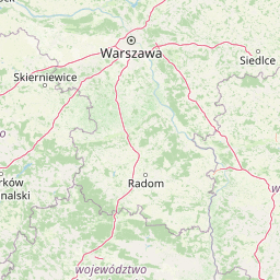
Map view of Wzgórza Kunowskie

Use this park location map to pinpoint Wzgórza Kunowskie in Poland, understand its exact geographic position, and read its mapped placement within the surrounding landscape more clearly.

Pigeon | © OpenStreetMap contributors

Location context for Wzgórza Kunowskie

Świętokrzyskie Voivodeship
Recorded earthquake history

Explore Historical Earthquake Records Associated with Wzgórza Kunowskie

View the comprehensive archive of recorded seismic events mapped to the Wzgórza Kunowskie landscape. This collection helps users identify historical earthquake activity by magnitude and distance, providing a clearer understanding of the regional seismic context beyond the park boundaries.

Wzgórza Kunowskie Earthquake History

Catalogued events

2 events

Strongest magnitude

Magnitude 3.2

Most recent event

Aug 21, 1996

This history includes earthquakes recorded inside the park or within 50 km of its borders

Park atlas

Compare nearby protected landscapes, river valleys, and regional habitat mosaics.

Explore Parks Near Wzgórza Kunowskie and Protected Areas Across the Surrounding Region

Browsing other protected areas near Wzgórza Kunowskie reveals connected ecological corridors and transitional lowland terrains across south-central Poland. Comparing adjacent conservation sites helps contextualize local dune and river valley habitats within a broader regional framework.
Watercolor illustration of rolling hills with green forests in the foreground and purple, green, pink, and yellow mountain ranges in the background
National parkŚwiętokrzyskie Voivodeship
3.5 km away#1 closest

Southwest

Świętokrzyski National Park: Protected Mountain Terrain in Świętokrzyskie Voivodeship

Geography and landscape mapping for Poland's oldest mountain range

Świętokrzyski National Park encompasses the highest ridges of the Świętokrzyskie Mountains, showcasing a landscape defined by expansive granite boulder fields and primeval fir forests. This atlas entry provides a detailed look at the park's topography, ranging from the prominent Łysica peak to the protected valley floors, highlighting the geological and biological diversity preserved within this central Polish sanctuary.

Area
76.26 km²
Established
1950
IUCN
II
Visitors
168K annual
National parkŚwiętokrzyskie Voivodeship
3.5 km away#2 closest

West

Świętokrzyski Park Narodowy: Protected Forests and Mountain Geography in Central Poland

A preserved landscape of ancient fir forests and rubble fields

Situated within the Świętokrzyskie Voivodeship, this protected area guards the Łysogóry range and its rare forest associations. The landscape is characterized by its dramatic gołoborza rubble fields and dense mixed-woodland terrain, providing a unique look into the natural geography of the region.

Area
76.26 km²
Established
1950
Visitors
168K annual
Relief
Mountain
Nature reserveŚwiętokrzyskie Voivodeship
About 12 km away#3 closest

South

Małe Gołoborze Nature Reserve: Mapping Cambrian Geology and Forested Ridge Ecosystems

A study of protected terrain in the Świętokrzyskie Voivodeship

Małe Gołoborze Nature Reserve stands as a preserved fragment of the Jeleniowskie Range, showcasing rare surface exposures of Cambrian quartzite sandstones alongside mature deciduous woodland. This entry offers a focused perspective on the reserve's topography, including its signature boulder slope and the valley floor that reveals the underlying geological foundations of central Poland's mountain landscape.

Area
0.216 km²
Established
1994
Relief
Mountain
Climate
Temperate
Protected landscapeŚwiętokrzyskie Voivodeship
15 km away#4 closest

West

Suchedniowsko-Oblęgorski Park Krajobrazowy: A Protected Landscape in Świętokrzyskie

Geographic terrain, forest ecosystems, and industrial heritage

Located in the Świętokrzyskie Voivodeship, this protected area preserves significant forest stands and historic industrial remnants. The terrain captures the intersection of plateau geology and hill country, hosting the headwaters of the Bobrza and Krasna rivers within a culturally layered, heavily forested environment.

Area
198.95 km²
Established
1988
Relief
Mountain
Climate
Temperate
Protected landscapeŚwiętokrzyskie Voivodeship
16 km away#5 closest

Southwest

Cisowsko-Orłowiński Park Krajobrazowy: Protected Landscape and Geological Atlas

Mapping biodiversity and Paleozoic formations in Świętokrzyskie, Poland

Cisowsko-Orłowiński Park Krajobrazowy stands as a center for biodiversity in southeastern Poland, protecting rare peat-bog forests and 200-year-old tree stands. This atlas profile highlights the park's distinct geological character, from the volcanic rock exposures at Sieraków to the fossil-rich sandstone cliffs at Zalesie, offering insight into the complex mosaic of the Góry Świętokrzyskie foothills.

Area
206.93 km²
Established
1988
Relief
Mountain
Climate
Temperate
Nature reserveŚwiętokrzyskie Voivodeship
About 17 km away#6 closest

East

Rezerwat przyrody Modrzewie: Protected Oak-Lime and Polish Larch Forest Reserve

Forest landscape discovery in the Świętokrzyskie region of Poland.

Located in the Kamienna Valley, Rezerwat przyrody Modrzewie acts as a vital protected area for mature, near-primary oak-lime forest. This nature reserve provides essential botanical context for the Polish larch, embedding a rich woodland fragment within the wider geographical tapestry of the Świętokrzyskie Voivodeship.

Area
0.047 km²
Established
1971
Relief
Lowland
Climate
Temperate
Nature reserveświętokrzyskie
20 km away#7 closest

South

Ostoja Żyznów Protected Landscape: Loess Ravines and River Valleys of Świętokrzyskie

A dense mosaic of xerothermic grasslands and mixed forest ecosystems

Ostoja Żyznów protects a compact yet ecologically rich region characterized by deep loess gullies and the meandering paths of the Koprzywianka and Kacanka rivers. The area creates a striking transitional landscape, shifting from flat agricultural plateaus to steep, forest-covered ravines and cliff-like river walls. This site offers significant value for understanding regional biodiversity, featuring a rare combination of warm-dry grasslands and moisture-dependent peatland habitats in the heart of Poland.

Area
44.8 km²
Established
2011
Relief
Mixed relief
Climate
Temperate
Nature reserveświętokrzyskie
24 km away#8 closest

West

Ostoja Wierzejska Nature Reserve: Protected Forest and Ridge Geography in Świętokrzyskie

Ecological corridors and rare fir forest habitat mapping

Uncover the landscape characteristics of Ostoja Wierzejska, a protected area in Poland featuring quartzite ridges and diverse forest ecosystems. The reserve acts as a crucial ecological link within the Masłowskie Range, sheltering mature tree stands, rare fungi, and specialized invertebrates that define the unique phytosociology of the Świętokrzyskie Mountains.

Area
2.25 km²
Established
2011
Relief
Mountain
Climate
Temperate

Common questions about visiting, size, designation, and location context for Wzgórza Kunowskie

Wzgórza Kunowskie FAQs for park facts, access, geography, and protected area context

Find quick answers about Wzgórza Kunowskie, including protected-area facts, park geography, trail and visitor context, and how the park fits into its surrounding country and regional landscape.
MoriAtlas Explorer

Continue Your Protected Areas Search Across the Global Atlas

Deepen your exploration by continuing the structured search for national parks and protected areas worldwide. Utilize the comprehensive filtering capabilities to compare different conservation landscapes and refine your understanding of global park geography. Discover more about the distribution and characteristics of protected natural areas.

Global natural geography