Mori Atlas logo
Nature reserveNatura 2000-område nr. 54 Yding Skov og Ejer Skov

Analyzing the glacial moraine plateaus and spring-fed ecosystems in Region Midtjylland

Natura 2000-område nr. 54 Yding Skov og Ejer Skov: Protected Landscape and Regional Map

Natura 2000-område nr. 54 Yding Skov og Ejer Skov stands as a significant protected nature reserve situated on the highest moraine plateau in Denmark. This area in Region Midtjylland showcases a complex landscape of beech-dominated forests, calcareous seepage zones, and the spring-fed Bjergskov Bæk. Beyond its ecological value, the terrain preserves ancient Bronze Age burial mounds, offering a unique intersection of geological history and protected forest habitats.

Natura 2000beech forestsprings and seepageslow mountain plateaubronze age burial moundsbroadleaf woodland

Natura 2000-område nr. 54 Yding Skov og Ejer Skov

Nature reserve

Park overview

Structured park overview, official facts, and landscape profile for Yding Skov og Ejer Skov

Yding Skov og Ejer Skov park facts, protected area profile, and essential visitor context

Review the core facts for Yding Skov og Ejer Skov, including designation, size, terrain, visitor scale, habitats, and operating context in one park-focused overview.

About Yding Skov og Ejer Skov

Yding Skov og Ejer Skov is a compact but ecologically rich protected area in central-eastern Jutland, recognized under the European Union's Natura 2000 network as habitat area H50. It occupies part of the highest moraine plateau in Denmark, a glacially formed landscape whose elevation gives it both its scenic character and its unusual combination of dry sandy ridges, clay-rich depressions, and groundwater-fed slopes. The result is a varied forest landscape where different soil conditions support markedly different vegetation types within a short distance.

Woodland dominates the site, accounting for roughly 123 of the 130 hectares. Ownership is fragmented, reflecting the traditional Danish pattern of parcel forests with many individual owners, and this patchwork character shows up in the landscape as an alternating pattern of mature beech stands, mixed broadleaf woodland, and poorer conifer plantations. The forest mosaic is intersected by open seepage areas, small spring mires, and the slopes where calcareous groundwater emerges to form the headwaters of Bjergskov Bæk. This brook is a defining feature of the site, descending northward from the forest slopes to Lake Mossø, and its clean, stony, gravelly bed supports an unusually diverse community of small aquatic animals, including several rare species that depend on high water quality.

Beyond its ecological role, the area has strong cultural significance. The forest of Yding Skov contains the well-known Yding Skovhøj, a Bronze Age burial mound group whose highest mound reaches about 172 to 173 meters, placing it among the very highest natural points in Denmark. This combination of protected habitats, scenic plateau forest, spring-fed streams, and prehistoric monuments makes the site a notable destination for visitors interested in Danish nature and cultural heritage alike.

Quick facts and research context for Yding Skov og Ejer Skov

Yding Skov og Ejer Skov is a Danish Natura 2000 habitat area (designation H50) covering about 130 hectares, of which approximately 123 hectares are woodland. It lies in Skanderborg and Horsens municipalities in Region Midtjylland, in eastern Jutland, and is managed under Denmark's Natura 2000 plan adopted in 2011.

The site protects beech forest on mor, mull, and calcareous soils, along with alder-ash forests, acidic grassland, and spring-fed seepages. Its forests form a parcel-style mosaic with many different owners. Bjergskov Bæk, a fast-flowing, very clean brook with stony and gravelly beds, runs northward through the area to Lake Mossø. Around 12 hectares of the broader site are additionally protected under Section 3 of the Danish Nature Protection Act, covering watercourses, small lakes, mires, grassland, and freshwater meadows.

Protection and recognition

Terrestrial conservation framework, management scope, and recognition records

Natura 2000-område nr. 54 Yding Skov og Ejer Skov Protection Status and Designation

Terrestrial protection status, management scope, and official designation records for Natura 2000-område nr. 54 Yding Skov og Ejer Skov remain documented within verified conservation datasets. Formal conservation parameters, regional boundaries, and administrative recognition details provide essential context for understanding the protected landscape.

Protection details

Protection scope
Terrestrial
Transboundary protection
No
Park context

Deeper park guide and search-rich context for Yding Skov og Ejer Skov

Yding Skov og Ejer Skov history, landscape, wildlife, and travel context

Explore Yding Skov og Ejer Skov through its history, landscape character, ecosystems, wildlife, conservation priorities, cultural context, and seasonal travel timing in a structured park guide built for atlas discovery and search intent.

Why Yding Skov og Ejer Skov stands out

Yding Skov og Ejer Skov is best known for its unusual combination of exceptionally high-lying Danish beech forests on a glacial moraine plateau and for sheltering the Yding Skovhøj Bronze Age mound complex, which includes one of the highest points in Denmark. It is also notable for its dense concentration of spring-fed seepages that feed Bjergskov Bæk, a remarkably clean, fast-running brook with a rich community of small aquatic species, including rare organisms restricted to high-quality freshwater habitats.
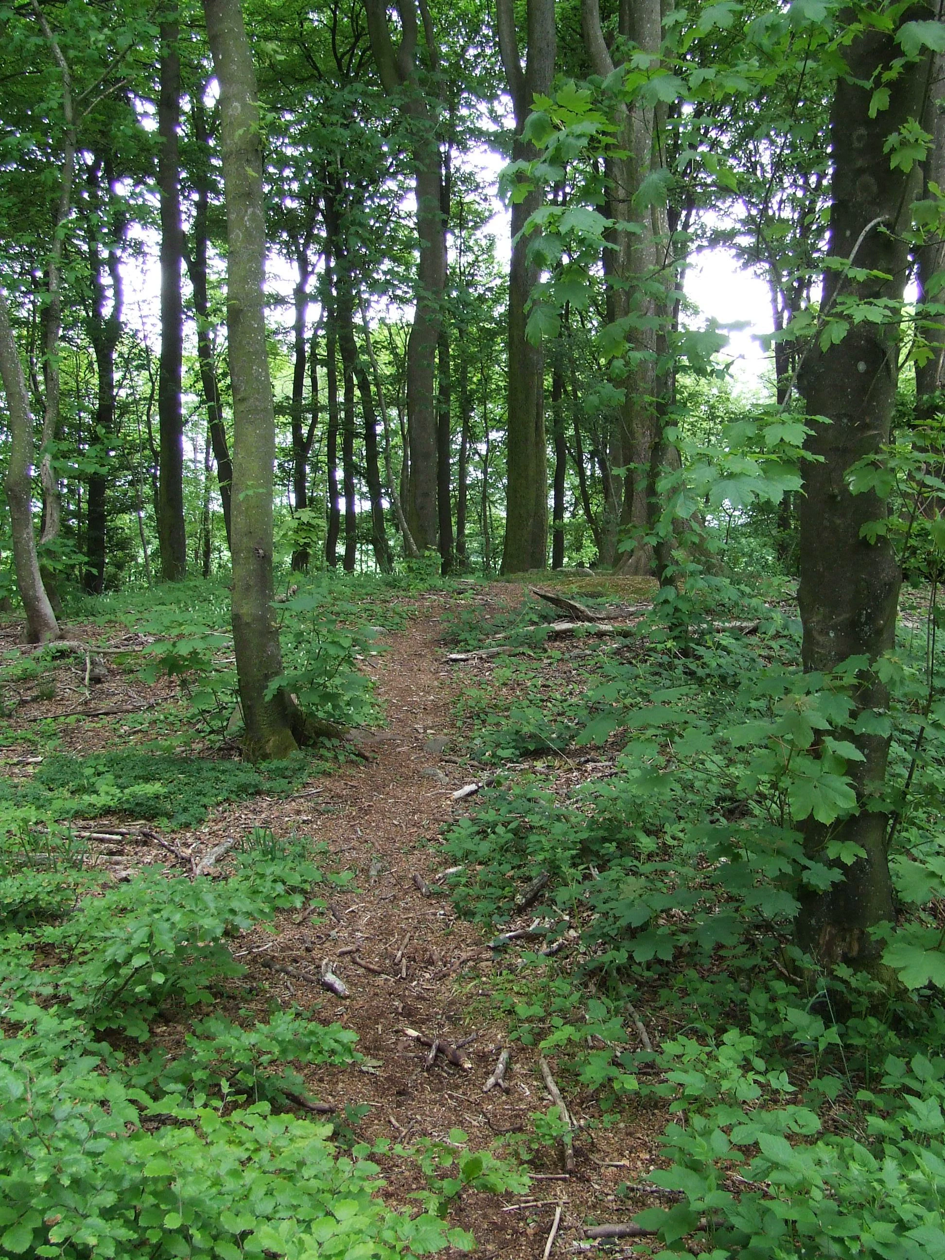
A narrow, worn dirt trail winds through a lush, dense green deciduous forest, leading up a slight incline which is identified as a Bronze Age burial mound.
A narrow dirt path leading toward the top of a Bronze Age burial mound in Yding Skov.

Yding Skov og Ejer Skov history and protected-area timeline

The protected status of Yding Skov og Ejer Skov is relatively recent in formal terms. The Natura 2000 plan for the area was adopted in 2011, after which the municipal councils of Skanderborg and Horsens, together with the Danish Nature Agency (Naturstyrelsen), prepared binding action plans to implement conservation measures. The plan has since been continued and developed in subsequent planning periods, with the most recent cycle covering 2022 to 2027.

Long before formal protection, however, the landscape carried deep human history. The Yding Skovhøj burial mound complex, consisting of several Bronze Age mounds including notable examples with multiple phases of construction, has attracted attention for centuries and remains one of the most visited prehistoric monuments in Denmark. The forest itself is shaped by centuries of parcel-style ownership, with many different owners maintaining distinct sections of woodland, a pattern that has helped produce the mosaic of broadleaf and conifer stands seen today.

Yding Skov og Ejer Skov landscape and geographic character

The landscape of Yding Skov og Ejer Skov is defined by its position on what is described as the highest moraine plateau in Denmark. This glacial landform gives the area its elevated character, with the famous Yding Skovhøj mound crest reaching roughly 172 to 173 meters above sea level. The plateau carries both sandy and clay-rich deposits, producing a varied ground surface where dry ridges alternate with moister depressions.

Forest is the dominant visual element, but it is not uniform. Beech stands on richer soils contrast with poorer conifer patches on sandy ground, and the boundary between these woodland types is often sharp and visible from the trails. Along the slopes that descend from the plateau, calcareous groundwater emerges as seepage zones, giving rise to small spring mires and feeding Bjergskov Bæk. This fast-flowing brook runs northward over stony and gravelly beds through the forested slopes before reaching Lake Mossø. Small lakes, mires, grassland patches, and freshwater meadows add further diversity to the terrain, creating a landscape that feels compartmentalized yet tightly interconnected by water and soils.

Yding Skov og Ejer Skov ecosystems, habitats, and plant life

Ecologically, Yding Skov og Ejer Skov is structured around its forested plateau and its network of seepage habitats. The Natura 2000 designation highlights beech forest on mor, beech on mull, beech on calcareous substrates, and alder-ash forest along watercourses as the principal habitat types. Acidic dry grassland is also part of the designation, reflecting the open vegetation that occurs where sandy, nutrient-poor soils prevent tree cover.

The forest mosaic supports different vegetation depending on soil and moisture conditions. On richer soils, especially where calcareous groundwater influences the root zone, beech grows tall and vigorous, often mixed with ash, elm, and other broadleaf species. On drier, sandier ridge sections, conifer plantations and more open woodland dominate, creating structural contrast within the forest. Along the slopes and in the valleys, alder and ash form wet woodland communities, and a string of small spring-fed seepages and source mires feed the headwaters of Bjergskov Bæk. Outside the forested zone, the site also includes small lakes, larger mires, dry grassland, and freshwater meadows, several of which are additionally protected under Section 3 of the Danish Nature Protection Act.

Yding Skov og Ejer Skov wildlife and species highlights

The wildlife significance of Yding Skov og Ejer Skov is most strongly tied to the aquatic and seepage habitats rather than to large mammals. Bjergskov Bæk, the clean fast-flowing brook draining the slopes northward to Lake Mossø, is described as having a particularly rich community of small aquatic animals, including several rare species that survive only in very clean freshwater. The brook lamprey is listed as a species of conservation interest for the Natura 2000 site, reflecting the importance of the stream's stony, gravelly, well-oxygenated beds.

The spring seepages and small mires along the forest slopes support distinctive invertebrate and plant communities associated with calcareous groundwater, while the dry acidic grassland patches provide habitat for insects and plants adapted to nutrient-poor conditions. The forest stands themselves host typical Danish broadleaf and mixed forest fauna, while the area's elevation and the open character of the plateau around Yding Skovhøj make the surrounding woodland attractive to a range of common forest bird species.

Yding Skov og Ejer Skov conservation status and protection priorities

Yding Skov og Ejer Skov is protected primarily through the European Natura 2000 network, with the site designated as EU habitat area H50. Its conservation value lies in the combination of high-quality beech forest habitats on different soil types, including calcareous beech woodland of high priority under the EU Habitats Directive, alongside alder-ash forests and spring seepages that support rare aquatic species. The acidic dry grassland habitat is also of priority conservation interest.

Management is framed by Denmark's Natura 2000 plan, first adopted in 2011, with binding action plans developed jointly by the affected municipalities and Naturstyrelsen. The plan is coordinated with the water management plan for the Randers Fjord district, recognizing the close link between the site's terrestrial habitats and the quality of its streams. In addition, several smaller areas within and adjacent to the site, including watercourses, small lakes, mires, dry grassland, and freshwater meadows, are protected under Section 3 of the Danish Nature Protection Act, adding an extra layer of national-level protection to the most sensitive natural features.

Yding Skov og Ejer Skov cultural meaning and human context

The cultural dimension of Yding Skov og Ejer Skov is anchored above all in the Yding Skovhøj Bronze Age burial mound complex. The forest contains several large prehistoric mounds, including multi-phase constructions where later Bronze Age builders enlarged earlier monuments. The tallest mound reaches roughly 172 to 173 meters above sea level, which makes the Yding Skovhøj area among the highest points in Denmark and explains the long-standing local and national interest in the site.

Beyond its prehistoric monuments, the area's cultural landscape reflects the Danish tradition of parcel forests with many separate owners. This ownership pattern has shaped the woodland mosaic for generations, and the modern Natura 2000 site sits within a broader cultural milieu of small forest holdings, rural villages, and the historic connection between forested uplands and the lake landscape of Mossø. The site is also a notable destination for visitors drawn to the combination of archaeology, woodland scenery, and the broader Danish heath and forest landscape of eastern Jutland.

Top sights and standout views in Yding Skov og Ejer Skov

Yding Skov og Ejer Skov combines ecological and cultural significance in a small but distinctive area. Its highest-profile natural assets are the beech woodlands on moraine plateau soils, including calcareous beech forest of EU priority status, and the spring seepage systems that feed Bjergskov Bæk, one of Denmark's notably clean, stony, gravelly upland brooks. The site's elevation, including the Yding Skovhøj area at around 172 to 173 meters, gives it a rare upland character within the generally low-lying Danish landscape.

Equally important is the prehistoric heritage, with the Yding Skovhøj burial mound complex standing as one of the most visited Bronze Age monuments in Denmark. Together, the protected beech, oak, and ash forests, the seepage and stream habitats, and the ancient mounds make the area a compact showcase of both Danish woodland conservation and cultural landscape history.

Best time to visit Yding Skov og Ejer Skov

Yding Skov og Ejer Skov can be visited year-round, but each season emphasizes a different aspect of the site. Spring and early summer are particularly rewarding for experiencing the seepage zones and Bjergskov Bæk, when groundwater flow is typically strong and the forest floor and mires are green and biologically active. Late spring and early summer also offer lush beech canopy and a wide range of forest wildflowers in mature broadleaf sections.

Summer brings full leaf cover and dense, shaded beech forest paths, while autumn highlights the colorful display of the broadleaves and is a popular time for combined visits to the Yding Skovhøj burial mounds. Winter visits are quieter; the open plateau around Yding Skovhøj can be exposed and cold, but the bare trees make it easier to observe the structure of the forest mosaic, the seepage areas, and the prehistoric mounds across the landscape.

Monthly climate preview

Long-term temperature and precipitation records measured across representative coordinate points

Natura 2000-område nr. 54 Yding Skov og Ejer Skov Climate Normals and Weather by Month

Representative coordinates for Natura 2000-område nr. 54 Yding Skov og Ejer Skov document a measured annual cycle of shifting monthly temperatures and steady precipitation averages. Examining the complete twelve-month climatology profile provides deeper analytical context on long-term regional patterns.
Annual mean8 °C
1 °C17 °C
Jan
Feb
Mar
Apr
May11°
Jun14°
Jul17°
Aug17°
Sep13°
Oct
Nov
Dec
Warmest month
July

16.7 °C

Coolest month
February

0.9 °C

Wettest month
October

2.7 mm/day

Driest month
April

1.5 mm/day

Park location guide

Geography guide, regional context, and park location map for Yding Skov og Ejer Skov

Yding Skov og Ejer Skov park geography, regions, and map view in Denmark

Understand where Yding Skov og Ejer Skov sits in Denmark through a broader geographic reading of the surrounding landscape, nearby location context, and its mapped position within the national park landscape.

How Yding Skov og Ejer Skov fits into Denmark

Denmark is a constitutional monarchy and Nordic country in Northern Europe. It is the southernmost of the Scandinavian countries, bordering Germany to the south, Norway to the north, and Sweden to the southwest. The country consists of the Jutland peninsula and an archipelago of islands, with Copenhagen as its capital and largest city. Denmark has a population of over 6 million and is characterized by flat, arable land, sandy coasts, and a temperate climate.

Wider geography shaping Yding Skov og Ejer Skov in Denmark

Denmark occupies the Jutland peninsula and roughly 406 islands in Northern Europe. It is situated between the North Sea to the west and the Baltic Sea to the east. The country borders Germany to the south and is connected to Sweden via the Øresund Bridge. Denmark is predominantly flat terrain with low elevation, the highest point being Møllehøj at 170.86 meters.

Map view of Yding Skov og Ejer Skov

Use this park location map to pinpoint Yding Skov og Ejer Skov in Denmark, understand its exact geographic position, and read its mapped placement within the surrounding landscape more clearly.

Pigeon | © OpenStreetMap contributors

Location context for Yding Skov og Ejer Skov

Region Midtjylland

Visualizing the moraine plateau, beech forest habitats, and spring environments

Natura 2000-område nr. 54 Yding Skov og Ejer Skov Photos and Landscape Scenery

Protected area imagery reveals the complex terrain, ancient burial mounds, and rich broadleaf woodland habitats defining Natura 2000-område nr. 54 Yding Skov og Ejer Skov. Visual documentation provides direct insight into the high moraine plateau geography, spring-fed brooks, and native forest canopy.

A narrow, worn dirt trail winds through a lush, dense green deciduous forest, leading up a slight incline which is identified as a Bronze Age burial mound.

Park atlas

Compare regional park geography and adjacent protected habitats across Jutland

Other Parks Near Natura 2000-område nr. 54 Yding Skov og Ejer Skov and Surrounding Protected Landscapes

Continue exploring protected areas near Natura 2000-område nr. 54 Yding Skov og Ejer Skov by browsing adjacent forest reserves and regional valley habitats. Expanding the geographic comparison provides a broader understanding of glacial moraine terrain and local conservation networks.
Panoramic watercolor illustration of a lake with green and pink trees and purple mountains in the background.
Protected areaCentral Denmark Region
About 8.2 km away#1 closest

Northwest

Natura 2000-område nr. 52: Protected Lake and River Landscape in Central Denmark

Mapping freshwater habitats, mires, and sandy heath ridges.

Centered on the Salten Å river valley and the expansive waters of Mossø and Salten Langsø, this protected area represents one of the most significant freshwater networks in Denmark. The territory includes diverse habitat types ranging from calcareous fens and rare raised bogs to sandy dry heaths and Atlantic beech woodlands, creating a vital ecological corridor within the Central Denmark Region.

Area
44.7 km²
Established
2011
A horizontal watercolor illustration depicting a river flowing through a lush green valley with rolling hills in the background under a soft, warm sky.
Protected areaCentral Denmark Region
About 8.8 km away#2 closest

Northwest

Salten Å Protected Area: Geography and Landscape Atlas of Central Denmark

Mapping inland river valleys and protected heathland corridors

Salten Å serves as a primary freshwater tributary and a protected natural corridor in the Central Denmark Region. This atlas entry provides insight into the valley's diverse terrain, spanning from the elevated inland heath at Sepstrup Sande to the forest-lined slopes and lake systems that characterize this unbroken Jutland habitat.

Water
Major water bodies
A soft watercolor painting depicting a scenic landscape with distant purple hills, green forests, and a body of water in the foreground, set against a plain white background.
Nature reserveRegion Midtjylland
About 16 km away#3 closest

Northwest

Silkeborgskovene Nature Reserve: Mapping the Forest and Lake Highlands of Central Jutland

Protected woodlands and freshwater mosaic in Denmark

Silkeborgskovene represents a profound example of Denmark's inland natural heritage, spanning a wide array of mature beech forests and clear lakes across the Søhøjland. This structured record provides geographic and habitat context for the reserve, detailing its role as a vital Natura 2000 protected area that preserves diverse ecosystems ranging from dry heathland to calcareous fens and unique brown-water aquatic environments.

Area
14.55 km²
Established
2011
Relief
Upland
Climate
Temperate
A horizontal watercolor painting depicting a soft, rolling landscape with green grassy fields, small clusters of trees, and tall grasses in the foreground.
Protected areaCentral Denmark Region
About 17 km away#4 closest

Southeast

Horsens Fjord, havet øst for og Endelave: Protected Coastal Landscape and Map Context

Mapping island habitats, reefs, and fjord geography in Denmark

Examine the geographic composition of Horsens Fjord, havet øst for og Endelave, a significant Natura 2000 site. This protected area connects inland fjord waters to open Kattegat coastlines, featuring a chain of islands, tidal sand flats, and submerged stone reefs that define this distinct ecological region.

Area
458.23 km²
Established
2011
Relief
Lowland
Climate
Temperate
A minimalist watercolor painting showing rolling green hills and pink heather under a white sky.
Protected landscapeSilkeborg Municipality
About 20 km away#5 closest

Northwest

Sindbjerg og Stovbjerg: Protected Heath and Glacial Landscape near Silkeborg Municipality

Twin heather summits overlooking the central Danish lake district

Sindbjerg og Stovbjerg features two prominent summits that have remained open heathland since early conservation efforts in 1919. This protected landscape offers a rare perspective on the Gudenå tunnel valley, providing panoramic vantage points across Borre Sø and the surrounding forested ridges of Jutland.

Area
0.22 km²
Established
1910
Relief
Upland
Climate
Temperate
Watercolor painting of a soft, hazy landscape with stylized evergreen trees and wildflowers in the foreground and rolling hills in the background.
Protected areaRegion Midtjylland
About 22 km away#6 closest

West

Natura 2000-område nr. 53 Sepstrup Sande, Vrads Sande, Velling Skov og Palsgård Skov Atlas

Protected glacial heathlands and forest landscapes in Central Jutland.

Analyze the topography of this expansive Danish protected area, where flat sandy plains meet undulating moraine hills. The territory contains diverse habitats including the Tingdalsøer lake chain, inland dune complexes, and dense beech woodlands, offering a deep look into the glacial history and regional geography of Central Jutland.

Area
55.72 km²
Relief
Mixed relief
Water
Major water bodies
A horizontal watercolor painting depicting a gentle, rolling green landscape with tall grasses in the foreground and soft hills in the background.
Protected areaAarhus Kommune
About 22 km away#7 closest

Northeast

Årslev Engsø Protected Area in Aarhus Kommune: Geographic and Wetland Map

Restored freshwater lake and ecological tunnel valley habitat

Årslev Engsø is a primary example of freshwater restoration located in the Aarhus Å valley of Denmark. This protected area features a shallow lake basin, managed wet meadows, and essential reed bed habitats that serve as a crucial filtering system for the downstream watershed. Through our mapped atlas, examine the terrain and geographic context of this wetland environment situated near the eastern Jutland coast.

Area
2.1 km²
Established
2003
Relief
Lowland
Climate
Temperate
Protected areaRegion Midtjylland
About 24 km away#8 closest

East

Kysing Fjord Protected Area: Coastal Lagoon and Saltmarsh Geography in Region Midtjylland

Mapped coastal lagoon and wetland protected area

Kysing Fjord serves as a significant coastal lagoon system on the eastern Jutland coast. This protected area in Region Midtjylland integrates shallow lagoon waters, saltmarsh meadows, and riverine terrain, offering a precise look at managed coastal landscapes and their ecological importance for wintering bird populations.

Area
3.7 km²
Established
1942
Relief
Lowland
Climate
Temperate

Common questions about visiting, size, designation, and location context for Yding Skov og Ejer Skov

Yding Skov og Ejer Skov FAQs for park facts, access, geography, and protected area context

Find quick answers about Yding Skov og Ejer Skov, including protected-area facts, park geography, trail and visitor context, and how the park fits into its surrounding country and regional landscape.
MoriAtlas Explorer

Continue Your Protected Areas Search Across the Global Atlas

Deepen your exploration by continuing the structured search for national parks and protected areas worldwide. Utilize the comprehensive filtering capabilities to compare different conservation landscapes and refine your understanding of global park geography. Discover more about the distribution and characteristics of protected natural areas.

Global natural geography