

Mori Atlas logo
Wildlife reserveYUS Conservation Area

Analyzing the altitudinal gradient and community-based conservation model of this unique wildlife reserve

YUS Conservation Area: A Protected Landscape Across the Huon Peninsula and Saruwaged Mountains

YUS Conservation Area encompasses a vast 760 square kilometer landscape in Morobe Province, extending from the coral reefs of the northern coast up to the 4,000-meter peaks of the western Saruwaged Mountains. This protected area tracks the river valleys of the Yopno, Uruwa, and Som, creating a continuous corridor of tropical lowland, hill, and montane forest habitats. By integrating customary land into a formal protection framework, this reserve serves as a vital stronghold for the endangered Matschie's tree-kangaroo and diverse endemic wildlife.

tropical forestcommunity-based conservationcustomary landendemic wildlifetree-kangaroo habitatHuon Peninsula

YUS Conservation Area

Wildlife reserve

Park overview

Structured park overview, official facts, and landscape profile for YUS Conservation Area

YUS Conservation Area park facts, protected area profile, and essential visitor context

Review the core facts for YUS Conservation Area, including designation, size, terrain, visitor scale, habitats, and operating context in one park-focused overview.

About YUS Conservation Area

YUS Conservation Area represents a new generation of large, community-led protected landscapes in Papua New Guinea. Designated in 2009 and developed over more than a decade of groundwork with local landowners, it was the first area in the country to be formally recognized as a conservation area, and it remains one of the most prominent examples of how customary land tenure can support conservation goals in Melanesia.

Geographically, the area sits on the Huon Peninsula in Morobe Province, with the regional capital Lae nearby as a reference point. Its boundary draws together very different environments: fringing coral reefs and coastal ecosystems on the northern shore, broad tracts of tropical lowland and hill forest in the interior river valleys, and the upper slopes of the western Saruwaged Mountains, where ridges and summits approach 4,000 meters in elevation. This range of habitats is the reason YUS can support such a wide variety of species, from birds of paradise in the montane canopy to tree-kangaroos in the moss forests above.

The conservation area is named after the Yopno, Uruwa and Som rivers, three waterways whose valleys define the heart of the reserve and the lives of the communities living within it. Thirty-five villages have formally pledged portions of their customary land to the conservation effort, committing to keep these lands free of hunting, logging and mining. The combination of strong local commitment, international technical support, and a landscape of national scenic and ecological significance gives YUS a distinctive identity among Pacific protected areas.

Quick facts and research context for YUS Conservation Area

YUS Conservation Area is located on the Huon Peninsula in Morobe Province, Papua New Guinea, with the nearest major city being Lae. It was established in 2009 as Papua New Guinea's first conservation area.

The protected zone covers about 760 square kilometers of tropical forest and coastal habitat, extending from northern coral reefs up to the high peaks of the western Saruwaged Mountains. It is named after the Yopno, Uruwa and Som rivers that flow through its landscape. Although the land remains under customary ownership, villagers from 35 communities have formally pledged to prohibit hunting, logging and mining within the conservation area.

Protection and recognition

Documented management scope and official protected area records

YUS Conservation Area Protection Status and International Recognition Data

YUS Conservation Area holds a documented mixed protection status within regional conservation frameworks. Official records compile management scope and international recognition data for structured park analysis.

Protection details

Protection scope
Mixed
Transboundary protection
No
Park context

Deeper park guide and search-rich context for YUS Conservation Area

YUS Conservation Area history, landscape, wildlife, and travel context

Explore YUS Conservation Area through its history, landscape character, ecosystems, wildlife, conservation priorities, cultural context, and seasonal travel timing in a structured park guide built for atlas discovery and search intent.

Why YUS Conservation Area stands out

YUS Conservation Area is best known as a stronghold for the endangered Matschie's tree-kangaroo, an endemic species whose survival is closely tied to the survival of New Guinea's montane forests. It is also recognized for its unusually broad altitudinal range, which compresses coral reefs, lowland rainforest, hill forest and high-mountain environments into a single protected landscape. A second defining trait is its community-based conservation model. Rather than relying on top-down government enforcement, YUS was created through long-term collaboration between local landowners, the Woodland Park Zoo's Tree Kangaroo Conservation Program, and development partners, making it a landmark example of customary-land conservation in the Pacific.

YUS Conservation Area history and protected-area timeline

The YUS Conservation Area was established in 2009, becoming Papua New Guinea's first formally recognized conservation area. Its creation was the culmination of more than twelve years of work by the Tree Kangaroo Conservation Program (TKCP) of Woodland Park Zoo, which had been engaging with local communities and the PNG government to design a model that would fit the realities of customary land ownership.

The push to protect this landscape grew out of concern for the endangered Matschie's tree-kangaroo, an endemic species whose range was increasingly threatened by hunting and forest loss. Rather than imposing restrictions from outside, the program worked with landowners across 35 villages to secure voluntary pledges to keep hunting, logging and mining out of designated portions of their land. International partners, including Conservation International, National Geographic, and the German Ministry for the Environment acting through KfW under the International Climate Change Initiative, helped support the process.

In 2012, a team of 12 rangers was established to help map and patrol the conservation area, turning the community pledges into an actively managed protected landscape. Since then, YUS has continued to serve as both a refuge for wildlife and a working demonstration of how traditional land tenure and modern conservation objectives can be combined in Papua New Guinea.

YUS Conservation Area landscape and geographic character

The landscape of YUS Conservation Area is shaped by an extraordinary altitudinal gradient compressed within a relatively small footprint. On its northern edge, the protected area meets the sea, where coral reefs fringe the coast of the Huon Peninsula. Moving inland, the terrain climbs through river valleys carved by the Yopno, Uruwa and Som rivers, giving way to broad belts of tropical lowland and hill forest.

Further south, the land rises into the western ranges of the Saruwaged Mountains, a rugged spine of ridges, valleys and high peaks reaching roughly 4,000 meters. These upper elevations support cooler montane and moss forest environments that contrast sharply with the warm, humid lowlands below. The combination of coastal ecosystems, riverine forest, mid-elevation rainforest and high mountain habitat gives YUS a layered scenery that changes dramatically over short distances.

YUS Conservation Area ecosystems, habitats, and plant life

Ecologically, YUS Conservation Area reflects the classic stratification of New Guinea's tropical landscapes, with distinct habitat types stacked from sea level to the high mountains. The area's tropical forests include lowland rainforest along the river systems, increasingly mossy and cooler hill forest at mid-elevations, and montane forest with thinner, more open canopy as the slopes approach the Saruwaged peaks.

This vertical layering creates room for a wide range of ecological communities. Coral reef ecosystems along the northern coast add a marine dimension to a reserve otherwise defined by forest. Inland, the combination of intact primary forest and varied altitude supports rich insect, amphibian and plant communities typical of one of the world's most biodiverse tropical islands. The result is a landscape where ecological transitions occur over very short distances, reinforcing the conservation importance of protecting the whole altitudinal gradient rather than isolated patches.

YUS Conservation Area wildlife and species highlights

YUS Conservation Area supports a rich cross-section of New Guinea's fauna, with recorded presence of 268 bird species, 44 mammal species and 26 frog species across its varied habitats. Its wildlife profile is strongly shaped by the forest canopy, where many of the region's most distinctive species are found.

Among birds, the area hosts emblematic species such as the palm cockatoo, dwarf cassowary, Pesquet's parrot, emperor bird-of-paradise, Wahnes's parotia and the Huon astrapia, the last of which is closely tied to the Huon Peninsula. Mammals include the common spotted cuscus, striped possum, small dorcopsis, Brown's pademelon and mountain cuscus, along with the conservation area's signature species, the endangered Matschie's tree-kangaroo.

Forests at different elevations harbor different animal communities, with lowland and hill forest supporting larger mammals and ground-dwelling species, while higher, mossier elevations provide habitat for montane specialists such as the tree-kangaroo. The mix of habitat types within a single protected area gives YUS particular importance for both widespread New Guinea species and those whose ranges are restricted to particular forest zones.

YUS Conservation Area conservation status and protection priorities

YUS Conservation Area matters from a conservation perspective because it protects an exceptionally broad gradient of New Guinea ecosystems, from coastal reefs to high-mountain forest, under a single conservation framework. It is a critical refuge for the endangered Matschie's tree-kangaroo, an endemic species whose future is closely linked to the integrity of these forests.

The area's significance goes beyond wildlife. It was created under Papua New Guinea's first conservation-area designation and has become a leading example of how customary-owned land can be brought into formal protection without displacing the communities that depend on it. With 35 villages pledging to keep their pledged lands free of hunting, logging and mining, the reserve demonstrates a model of conservation that combines local stewardship with international support, including partners such as the Woodland Park Zoo's Tree Kangaroo Conservation Program, Conservation International, National Geographic and the German Ministry for the Environment acting through KfW.

The establishment of a 12-strong ranger team in 2012 marked a shift from pledge-based protection to active patrolling and monitoring. This strengthened the conservation area's role as both a stronghold for rare species and a reference point for community-based conservation in Melanesia.

YUS Conservation Area cultural meaning and human context

The cultural fabric of YUS Conservation Area is inseparable from its landscape. The land remains under customary ownership, and the conservation area exists only because villagers from 35 communities chose to collaborate on its creation. Local identity, livelihoods and traditional land-use patterns are linked closely to the Yopno, Uruwa and Som river valleys that give the area its name.

By working with the Tree Kangaroo Conservation Program and the PNG government over more than a decade, these communities helped design a model in which cultural stewardship of land dovetails with formal conservation goals. Rather than separating people from nature, YUS incorporates the participation of surrounding villages as a central element of its identity, reflecting broader traditions of communal land management in Papua New Guinea.

Top sights and standout views in YUS Conservation Area

YUS Conservation Area stands out for its scale, its elevation range, and the depth of community involvement behind it. Covering about 760 square kilometers, it links coral reefs, tropical lowland forest and the high peaks of the Saruwaged Mountains in a single protected landscape.

It is also notable as an early and influential example of community-based conservation built on customary land in Papua New Guinea. The combination of an endangered endemic flagship species, a community-led protection model, and a dramatic multi-habitat setting gives YUS a strong and distinctive profile among protected areas in the Pacific.

Best time to visit YUS Conservation Area

The climate of the Huon Peninsula is tropical and humid year-round, with rainfall patterns shaping the character of a visit rather than a sharp seasonal change. Conditions tend to be drier over much of the area during the southern hemisphere winter months, which can make forest walks, river crossings and ranger-patrol routes more manageable and visibility for birdwatching more rewarding.

Higher elevations within the conservation area, climbing toward the peaks of the Saruwaged Mountains, are cooler and can be cloudier than the coast and lowlands, and the moss forests that harbor species such as Matschie's tree-kangaroo are best appreciated when conditions are calmer. Travelers interested in reef environments along the northern coast may prefer periods of calmer sea conditions. Because access to much of the area depends on local guides and community arrangements, the practical character of a visit tends to be shaped as much by partnership with villages as by season.
Monthly climate preview

Track representative monthly temperature averages and precipitation totals across the protected landscape

YUS Conservation Area Climate Normals, Long-Term Temperature and Precipitation Rhythm

Representative coordinate records show consistent baseline temperatures alongside distinct seasonal shifts in daily precipitation across the terrain. Reviewing the comprehensive monthly climate data reveals complete long-term patterns for baseline thermal conditions and moisture distribution.
Annual mean23 °C
22 °C23 °C
Jan23°
Feb22°
Mar22°
Apr22°
May23°
Jun22°
Jul22°
Aug22°
Sep23°
Oct23°
Nov23°
Dec23°
Warmest month
October

23 °C

Coolest month
July

22.3 °C

Wettest month
March

6.6 mm/day

Driest month
August

1.9 mm/day

Park location guide

Geography guide, regional context, and park location map for YUS Conservation Area

YUS Conservation Area park geography, regions, and map view in Papua New Guinea

Understand where YUS Conservation Area sits in Papua New Guinea through a broader geographic reading of the surrounding landscape, nearby location context, and its mapped position within the national park landscape.

How YUS Conservation Area fits into Papua New Guinea

Papua New Guinea is an island nation in the southwestern Pacific Ocean, comprising the eastern half of the island of New Guinea and hundreds of offshore islands. It gained independence from Australia in 1975 and operates as a constitutional monarchy within the Commonwealth. The country is renowned for having the world's highest linguistic diversity, with over 840 known languages.

Wider geography shaping YUS Conservation Area in Papua New Guinea

Papua New Guinea occupies the eastern half of the island of New Guinea and hundreds of smaller islands in Melanesia. It shares a land border with Indonesia to the west and has maritime boundaries with Australia to the south and the Solomon Islands to the east. The terrain is predominantly mountainous, with the land supporting extraordinary biodiversity.

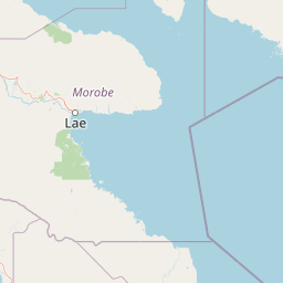
Map view of YUS Conservation Area

Use this park location map to pinpoint YUS Conservation Area in Papua New Guinea, understand its exact geographic position, and read its mapped placement within the surrounding landscape more clearly.

Pigeon | © OpenStreetMap contributors

Location context for YUS Conservation Area

Morobe Province
Park atlas

Compare regional park geography, tropical forest reserves, and connected conservation terrain.

Explore Other Parks Near YUS Conservation Area and Surrounding Protected Landscapes

Browsing other protected areas near YUS Conservation Area provides valuable geographic context for understanding regional tropical forests and mountain ecosystems. Comparing surrounding conservation landscapes helps trace wider patterns of biodiversity across the Huon Peninsula and neighboring mountain ranges.
National parkMorobe Province
About 153 km away#1 closest

South

McAdam National Park; Geographic Atlas of Protected Highland Forests in Morobe Province

Highland montane forest and rugged ridge landscapes

McAdam National Park preserves a rugged stretch of montane rainforest in Papua New Guinea's Bulolo region. Rising over 1,200 meters, this protected area features steep forested slopes and narrow valleys that define the geography of the Morobe interior. Our atlas provides insights into the park's boundaries and its position within the broader highland ecosystem of the province.

Relief
Mountain
Scope
Terrestrial
Water
Minor water
Stylized illustration of a mountain with waterfalls, river, and trees under a bright sky with clouds
Protected areaPapua New Guinea
About 196 km away#2 closest

West

Mount Wilhelm Protected Area: Papua New Guinea's Highest Peak and Alpine Terrain

Mapped geography and protected landscape context for a key Oceania peak.

Mount Wilhelm represents a significant protected area and the highest mountain in Papua New Guinea. Situated within the Bismarck Range, its dramatic granite peak defines a unique alpine environment, transitioning from dense rainforests to high-altitude grasslands. The presence of twin glacial lakes, Piunde and Aunde, adds to its distinctiveness, offering insight into the region's varied natural terrain and its role as a key geographical landmark.

Relief
Mountain
Climate
Alpine
Access
Moderate access
Scope
Terrestrial
Wildlife reserveChimbu Province
About 219 km away#3 closest

Southwest

Crater Mountain Wildlife Management Area: Geography and Protected Land Boundaries in Chimbu Province

Central highland rainforest and cordillera wilderness terrain.

Crater Mountain Wildlife Management Area encompasses a massive tract of undisturbed highland rainforest across the central cordillera of Papua New Guinea. This protected zone demonstrates a unique intersection of tropical montane biodiversity and community-led conservation, providing an essential refuge defined by steep topography, persistent moisture, and continuous forest cover that stretches across the Chimbu Province.

Relief
Highland
Water
Major water bodies
Nature reserveWestern Highlands Province
About 295 km away#4 closest

West

Baiyer River Sanctuary: Protected Highland Rainforest and River Valley Geography

Nature reserve in the Western Highlands Province of Papua New Guinea.

Located within the Western Highlands, Baiyer River Sanctuary protects 740 hectares of dense oak-dominated rainforest. This nature reserve provides essential habitat for birds-of-paradise, maintaining a continuous canopy across high-rainfall mountain slopes that bridges the transition between lowland and alpine ecosystems.

Area
7.4 km²
Established
1968
Relief
Upland
Climate
Tropical
Wildlife reserveSouthern Highlands Province
About 388 km away#5 closest

West

Lake Kutubu Wildlife Reserve: Geographic Boundaries and Highland Ecosystem Mapping

Protected freshwater terrain in the Southern Highlands Province

Lake Kutubu represents an essential protected landscape in the Papua New Guinea highlands, serving as a critical upland basin for diverse freshwater species. This overview highlights the reserve's unique geographic setting, covering its expansive 19-kilometer stretch, surrounding montane forests, and its role within the Kikori River catchment. Access detailed landscape context and regional environmental data for this globally significant lacustrine ecosystem.

Area
51.84 km²
Relief
Mountain
Scope
Terrestrial
Water
Water-dominated
National parkCentral Province
About 396 km away#6 closest

South

Varirata National Park: Protected Rainforest and Highland Terrain Atlas

Mapped geography of Central Province rainforest reserves

Varirata National Park is a significant protected area within the Central Province of Papua New Guinea, known for its elevated tropical rainforest ridges and varied topography. This map-based entry provides context on its landscape character, environmental setting, and role as an essential forest refuge in the highlands near the national capital.

Relief
Highland
Water
Minor water
Wildlife reserveWestern Province
About 674 km away#7 closest

Southwest

Tonda Wildlife Management Area: Atlas of Protected Wetlands and Savanna Landscapes

Geographic overview of Papua New Guinea's largest wetland conservation zone

Spanning nearly 6,000 square kilometres of floodplain, Tonda Wildlife Management Area is defined by its exceptionally flat terrain and shifting mosaic of monsoon forest, tidal channels, and freshwater marshes. This protected landscape functions as an essential ecological bridge within the Trans-Fly ecoregion, maintaining deep connections to international conservation partners while preserving the integrity of its native bird and mammal habitats.

Area
5,900 km²
Established
1975
National parkSouth Papua
About 682 km away#8 closest

Southwest

Wasur National Park National Park: Mapped Protected Boundaries in South Papua

Explore the geographic context and park boundaries.

Delve into the specific protected area identity of Wasur National Park, a national park situated within the South Papua region. This page offers detailed geographic context, focusing on its mapped boundaries and its significance as a protected landscape. It provides a factual basis for understanding the park's place within Indonesia's network of natural areas for structured atlas exploration.

Area
4,138 km²
Established
1990
IUCN
II
Visitors
2.3K annual

Common questions about visiting, size, designation, and location context for YUS Conservation Area

YUS Conservation Area FAQs for park facts, access, geography, and protected area context

Find quick answers about YUS Conservation Area, including protected-area facts, park geography, trail and visitor context, and how the park fits into its surrounding country and regional landscape.
MoriAtlas Explorer

Continue Your Protected Areas Search Across the Global Atlas

Deepen your exploration by continuing the structured search for national parks and protected areas worldwide. Utilize the comprehensive filtering capabilities to compare different conservation landscapes and refine your understanding of global park geography. Discover more about the distribution and characteristics of protected natural areas.

Global natural geography
