

Mori Atlas logo
Wildlife reserveZugvogelschutzgebiet L’Isle-Verte

Mapping the tidal marsh boundaries and essential migratory bird habitats of the St. Lawrence Estuary

Zugvogelschutzgebiet L’Isle-Verte Wildlife Reserve: Coastal Wetland Geography and Protected Landscape Atlas

(L'Isle-Verte Migratory Bird Sanctuary)

Zugvogelschutzgebiet L’Isle-Verte functions as a critical protected wetland along the south shore of the St. Lawrence Estuary in Quebec. This wildlife reserve preserves expansive tidal flats and brackish marshes that serve as a vital staging point for migratory birds. The site offers a clear window into the coastal geography of the Bas-Saint-Laurent region, where tidal channels and nutrient-rich estuarine terrain define the protected landscape.

migratory bird sanctuarytidal marshestuary habitatSt. Lawrence Estuarywaterfowlshorbirds

Zugvogelschutzgebiet L’Isle-Verte

Wildlife reserve

Park overview

Structured park overview, official facts, and landscape profile for L'Isle-Verte Migratory Bird Sanctuary

L'Isle-Verte Migratory Bird Sanctuary park facts, protected area profile, and essential visitor context

Review the core facts for L'Isle-Verte Migratory Bird Sanctuary, including designation, size, terrain, visitor scale, habitats, and operating context in one park-focused overview.

About L'Isle-Verte Migratory Bird Sanctuary

The L'Isle-Verte Migratory Bird Sanctuary sits at the southern edge of the St. Lawrence Estuary, where freshwater from one of North America's largest river systems meets the saltwater influence of the Gulf of St. Lawrence. This transitional zone creates highly productive tidal wetlands that support dense populations of invertebrates, fish, and aquatic vegetation, forming an exceptionally rich food base for migratory and breeding birds.

Although modest in size, the sanctuary plays an outsized role in regional avian conservation. Its tidal marsh landscape provides resting, feeding, and refuelling habitat for waterfowl moving between northern breeding grounds and southern wintering areas. During the spring migration, the marshes fill with dabbling ducks such as northern pintails, mallards, gadwalls, northern shovelers, American wigeons, and blue-winged teals, while later in the year the focus shifts to nesting and brood-rearing by resident species.

The sanctuary is administratively connected to the broader Baie de L'Isle-Verte National Wildlife Area, and together these protected zones anchor a wider landscape of estuarine marshes recognized internationally under the Ramsar Convention. As an Important Bird Area, the site is monitored for its continued importance to both migratory and breeding bird populations. The combination of tidal marsh ecology, estuarine position, and conservation designations makes L'Isle-Verte a significant node within the North Atlantic flyway.

Quick facts and research context for L'Isle-Verte Migratory Bird Sanctuary

The sanctuary is located roughly 25 kilometres north-northeast of Rivière-du-Loup, near the municipality of L'Isle-Verte on the south shore of the St. Lawrence Estuary. It covers approximately 3.76 square kilometres of coastal tidal marsh habitat and was formally established in 1986. Administration falls under the Canadian Wildlife Service, and the area carries multiple international recognitions, including Ramsar wetland status and Important Bird Area designation under the name Marais de la baie de L'Isle-Verte.

Protection and recognition

Review documented terrestrial protection scope and official database records

Zugvogelschutzgebiet L’Isle-Verte Protection Status and Regional Designation Records

Evaluations for Zugvogelschutzgebiet L’Isle-Verte compile documented terrestrial protection status alongside verified global database records. Official repository entries detail management parameters and formal recognition histories without administrative speculation.

Protection details

Protection scope
Terrestrial
Transboundary protection
No
WDPA ID
555704279
Park context

Deeper park guide and search-rich context for L'Isle-Verte Migratory Bird Sanctuary

L'Isle-Verte Migratory Bird Sanctuary history, landscape, wildlife, and travel context

Explore L'Isle-Verte Migratory Bird Sanctuary through its history, landscape character, ecosystems, wildlife, conservation priorities, cultural context, and seasonal travel timing in a structured park guide built for atlas discovery and search intent.

Why L'Isle-Verte Migratory Bird Sanctuary stands out

L'Isle-Verte is best known for its tidal marsh habitat along the St. Lawrence Estuary and its role as a major migratory bird stopover site. The sanctuary hosts large concentrations of greater snow geese and Canada geese during seasonal migrations, alongside diverse assemblages of dabbling ducks and shorebirds. Its overlap with Ramsar and Important Bird Area designations underscores its international value for waterfowl conservation.
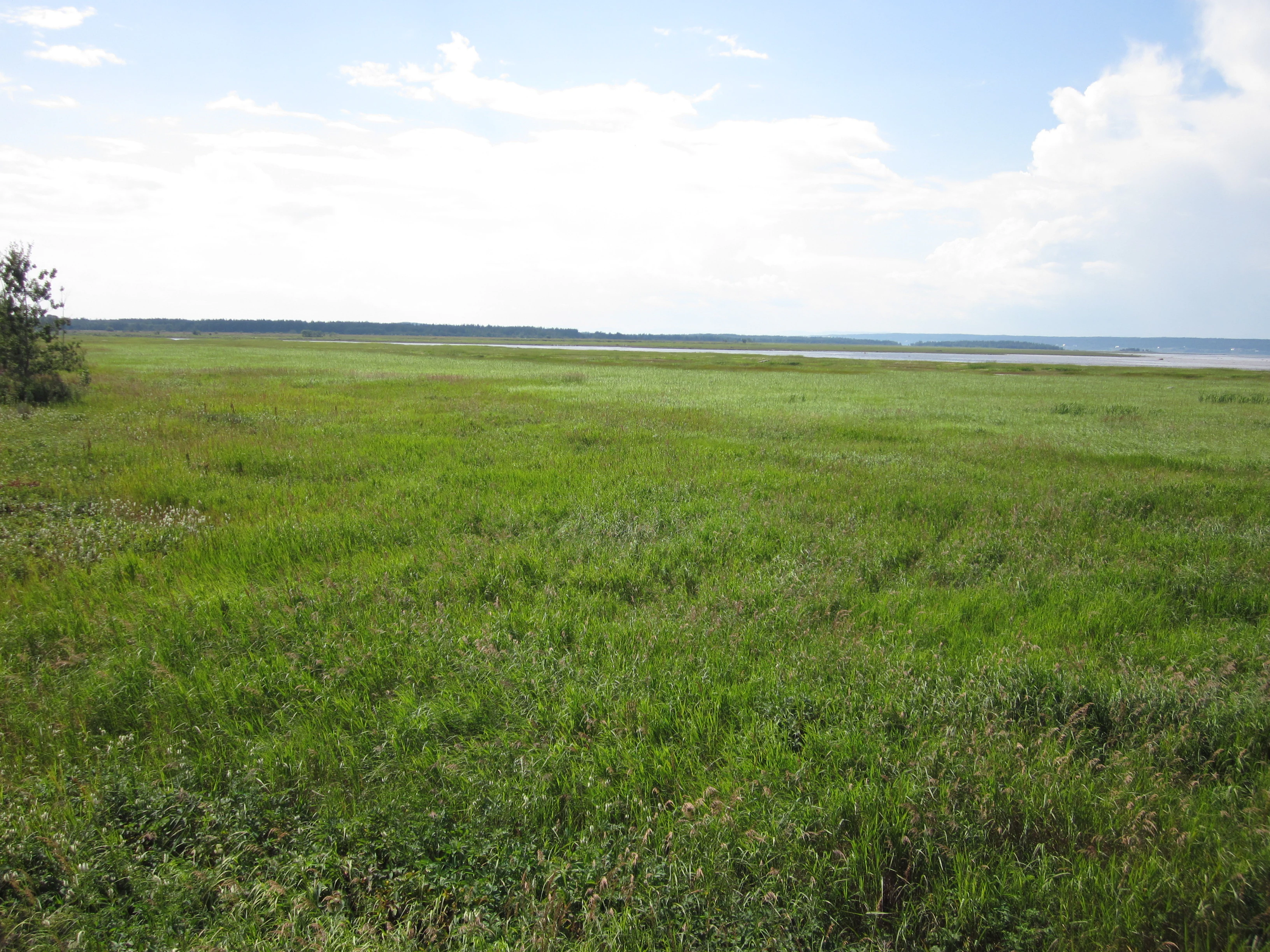
Baie de l'Isle-Verte National Wildlife Area marshes
View of the marshes at the Baie de l'Isle-Verte National Wildlife Area

L'Isle-Verte Migratory Bird Sanctuary history and protected-area timeline

L'Isle-Verte Migratory Bird Sanctuary was formally established in 1986 as part of Canada's national network of sanctuaries protecting migratory bird habitat. Its creation responded to the long-recognized importance of the St. Lawrence Estuary's tidal marshes for waterfowl and shorebirds, particularly the seasonal concentrations of snow geese and Canada geese that depend on these coastal wetlands during migration.

The sanctuary's later integration into the Baie de L'Isle-Verte National Wildlife Area expanded the federal protection footprint around the bay. It was subsequently recognized under the Ramsar Convention as a wetland of international importance and designated as an Important Bird Area under the Marais de la baie de L'Isle-Verte name, reinforcing the site's standing in both national and global conservation frameworks.

L'Isle-Verte Migratory Bird Sanctuary landscape and geographic character

The landscape of L'Isle-Verte is defined almost entirely by its tidal marsh environment at the interface between the St. Lawrence Estuary and the surrounding lowlands of the Bas-Saint-Laurent region. Gently sloping coastal terrain gives way to expansive intertidal flats, channels carved by tidal flow, and brackish marsh vegetation adapted to fluctuating salinity. The estuary here is wide and relatively shallow, concentrating nutrients and supporting the dense plant and invertebrate growth that defines the wetland's productivity.

Beyond the marsh edge, the surrounding area blends into rural coastal landscapes of the St. Lawrence lowlands, with small fishing communities, agricultural land, and patches of forest characteristic of the south shore. The sanctuary itself is a narrow coastal strip, with the tidal marsh at its core making up the dominant physical feature and defining how the site functions ecologically.

L'Isle-Verte Migratory Bird Sanctuary ecosystems, habitats, and plant life

Tidal marsh is the defining ecosystem of L'Isle-Verte Migratory Bird Sanctuary. The daily rhythm of tides shapes water levels, salinity, and sediment deposition, creating a dynamic environment dominated by halophytic and salt-tolerant plant communities. These conditions support abundant invertebrates and small fish, which in turn sustain large populations of waterfowl, waders, and marsh-nesting songbirds.

The estuary's nutrient-rich waters and sheltered coves produce a highly productive wetland that functions as both a feeding ground and a nursery for aquatic life. Because estuarine tidal marshes of this type are increasingly rare along heavily developed coastlines, the sanctuary preserves a representative example of an estuarine habitat type that has contracted significantly elsewhere in eastern Canada.

L'Isle-Verte Migratory Bird Sanctuary wildlife and species highlights

The sanctuary's wildlife profile is dominated by birds, particularly migratory waterfowl. Greater snow geese of the atlanticus subspecies and large flocks of Canada geese use the marshes as a major staging and stopover site during migration. In spring, the tidal flats attract northern pintails, mallards, gadwalls, northern shovelers, American wigeons, and blue-winged teals, drawn by the rich food resources of the estuary.

The site's breeding bird community includes species closely tied to coastal marsh habitats, such as black ducks, Nelson's sparrows, and savannah sparrows, while summer also brings short-eared owls, yellow warblers, white-throated sparrows, and song sparrows. A diverse shorebird assemblage makes use of the mudflats and edges, with species including whimbrels, lesser yellowlegs, black-bellied plovers, spotted sandpipers, Hudsonian godwits, Wilson's snipe, pectoral sandpipers, least sandpipers, and semipalmated sandpipers recorded in the sanctuary.

L'Isle-Verte Migratory Bird Sanctuary conservation status and protection priorities

L'Isle-Verte carries layered conservation status that reflects both its national and international importance. As a Migratory Bird Sanctuary under the Canadian Wildlife Service, it is protected under Canada's federal migratory bird legislation, which restricts activities that could harm migratory birds or their habitat. Its overlap with the Baie de L'Isle-Verte National Wildlife Area extends this protection to a broader estuarine landscape.

The site's designation as a Ramsar wetland recognizes it as a wetland of international importance, particularly for its role in supporting waterfowl populations along the Atlantic flyway. The parallel Important Bird Area designation under the name Marais de la baie de L'Isle-Verte places the sanctuary within a citizen-science and conservation-monitoring framework that tracks long-term changes in bird populations and habitat condition.

Top sights and standout views in L'Isle-Verte Migratory Bird Sanctuary

Key features that distinguish L'Isle-Verte include its large snow goose and Canada goose staging concentrations, its rich spring dabbling duck migrations, and its unusual overlap of Migratory Bird Sanctuary, National Wildlife Area, Ramsar, and Important Bird Area designations. The sanctuary's tidal marsh setting at the southern edge of the St. Lawrence Estuary gives it both ecological productivity and visual character rooted in the rhythms of the tides.

Best time to visit L'Isle-Verte Migratory Bird Sanctuary

Spring is the most ecologically dynamic period at L'Isle-Verte, when dabbling ducks and the early pulse of waterfowl migration bring strong bird activity to the tidal marshes. Late summer and early autumn offer opportunities to observe nesting species and the build-up of pre-migration flocks, while the broader St. Lawrence Estuary shoreline retains visual interest across seasons due to its tidal landscapes and rural coastal scenery.

Monthly climate preview

Long-term representative point measurements for temperature and precipitation by month

Zugvogelschutzgebiet L’Isle-Verte Climate Normals and Annual Temperature Rhythm

Representative coordinates record distinct annual temperature swings alongside moderate precipitation rates across the twelve-month cycle. Analyzing the complete monthly climate profile reveals specific long-term averages for each recorded period.
Annual mean3 °C
-13 °C17 °C
Jan-13°
Feb-12°
Mar-6°
Apr
May
Jun14°
Jul17°
Aug17°
Sep13°
Oct
Nov-1°
Dec-9°
Warmest month
July

17.4 °C

Coolest month
January

-13.2 °C

Wettest month
June

3.3 mm/day

Driest month
January

1.8 mm/day

Park location guide

Geography guide, regional context, and park location map for L'Isle-Verte Migratory Bird Sanctuary

L'Isle-Verte Migratory Bird Sanctuary park geography, regions, and map view in Canada

Understand where L'Isle-Verte Migratory Bird Sanctuary sits in Canada through a broader geographic reading of the surrounding landscape, nearby location context, and its mapped position within the national park landscape.

How L'Isle-Verte Migratory Bird Sanctuary fits into Canada

Canada is a federal parliamentary constitutional monarchy spanning North America from the Atlantic to the Pacific and Arctic Oceans. With a population of over 41 million, it is officially bilingual in English and French at the federal level. The country gained independence from the United Kingdom through a gradual process culminating in 1982.

Wider geography shaping L'Isle-Verte Migratory Bird Sanctuary in Canada

Canada occupies the northern portion of North America, sharing its longest international border with the United States. The country extends from the Atlantic Ocean to the Pacific Ocean and northward into the Arctic Ocean, giving it the longest coastline of any nation.

Map view of L'Isle-Verte Migratory Bird Sanctuary

Use this park location map to pinpoint L'Isle-Verte Migratory Bird Sanctuary in Canada, understand its exact geographic position, and read its mapped placement within the surrounding landscape more clearly.

Pigeon | © OpenStreetMap contributors

Location context for L'Isle-Verte Migratory Bird Sanctuary

Quebec
Recorded earthquake history

Examine the Earthquake History of Zugvogelschutzgebiet L’Isle-Verte

Explore the historical record of seismic events identified near the wetlands of Zugvogelschutzgebiet L’Isle-Verte. This dataset allows users to view mapped epicentres and event specifics through the MoriAtlas platform to better understand the regional seismic context of the St. Lawrence Estuary.

Zugvogelschutzgebiet L’Isle-Verte Earthquake History

Catalogued events

7 events

Strongest magnitude

Magnitude 4.9

Most recent event

Sep 23, 2014

This history includes earthquakes recorded inside the park or within 50 km of its borders

Visual reference guide to tidal marsh habitats and protected coastal wetlands

Zugvogelschutzgebiet L’Isle-Verte Photos, Landscapes, and Estuary Scenery

Visual documentation captures the expansive intertidal flats, brackish marsh vegetation, and coastal terrain that define the protected sanctuary. Examining these field photographs reveals the distinctive estuary environment and seasonal wetland characteristics of the protected landscape.

Baie de l'Isle-Verte National Wildlife Area marshes

Park atlas

Compare adjacent wetland habitats and surrounding coastal protected landscapes

Explore Protected Areas Near Zugvogelschutzgebiet L’Isle-Verte and Regional Parks

Browse other parks near Zugvogelschutzgebiet L’Isle-Verte to examine related wetland ecosystems and regional protected areas along the St. Lawrence Estuary. Extending the geographic comparison reveals broader patterns in coastal conservation and neighboring sanctuary geography.
Wildlife reserveBas-Saint-Laurent
About 1 km away#1 closest

East

Réserve nationale de faune de la baie de l'Isle-Verte: Bas-Saint-Laurent Protected Wildlife Area

Coastal salt marsh geography and waterfowl conservation sanctuary

Situated along the St. Lawrence Estuary, this wildlife reserve safeguards a rare and expansive tidal marsh environment. The area provides essential habitat for large migratory bird populations, serving as a landmark site for waterfowl conservation within the regional landscape of Bas-Saint-Laurent.

Area
3.2 km²
Established
1980
IUCN
IV
Relief
Lowland
Wildlife reserveQuebec
About 24 km away#2 closest

Southwest

Réserve nationale de faune des îles de l'Estuaire: Wildlife Reserve and Estuary Geography

Mapped protected island chain in the Quebec St. Lawrence Estuary.

This wildlife reserve encompasses a chain of small islands that provide predator-free nesting sites for seabirds and waterbirds. Situated along the St. Lawrence Estuary, the area acts as a critical link for regional conservation, supporting seals and marine life within a unique sedimentary landscape.

Area
4.04 km²
Established
1986
IUCN
Ia
Relief
Lowland
National parkQuebec
287 km away#3 closest

Southwest

La Mauricie National Park: Quebec National Park Atlas and Protected Landscape

Explore its mapped boundaries and natural terrain.

Delve into the protected landscape of La Mauricie National Park, a key national park situated within Quebec's diverse geography. This destination provides detailed insights into the park's mapped boundaries and its unique natural terrain, offering a structured approach to understanding protected areas and regional landscapes. It serves as an essential point for exploring the park's geographic identity and its place within the Canadian conservation atlas.

Area
536 km²
Established
1970
IUCN
II
Visitors
278.9K annual
Wildlife reserveNew Brunswick
About 327 km away#4 closest

Southeast

Portobello Creek National Wildlife Area: Protected Wetland Geography and Regional Atlas

Saint John River floodplain reserve in New Brunswick

Portobello Creek National Wildlife Area protects an expansive wetland complex characterized by riverine marshes, shrub thickets, and low-lying floodplain forests. As a key site within the Saint John River system, the reserve offers unique insight into the geomorphic and ecological character of Atlantic Canadian wetlands.

Area
21.54 km²
Established
1995
IUCN
Ia
Relief
Lowland
Wildlife reserveNew Brunswick
About 336 km away#5 closest

East

Île-du-Portage National Wildlife Area: Geographic Overview and Protected Island Mapping

A vital estuarine reserve on the New Brunswick coast

Study the coastal terrain of Île-du-Portage National Wildlife Area, an uninhabited island reserve situated at the junction of the Miramichi River and the Northumberland Strait. This overview focuses on the island's role as one of five National Wildlife Areas in New Brunswick, highlighting its significance within the broader estuarine geography and coastal maritime history of the Atlantic region.

Area
3.49 km²
Established
1979
IUCN
Ia
Relief
Lowland
National parkNew Brunswick
348 km away#6 closest

East

Kouchibouguac National Park: New Brunswick Protected Landscape Atlas

Mapped protected area boundaries and regional geography.

Kouchibouguac National Park is a designated national park offering a rich canvas for geographic discovery. This entry focuses on understanding its protected landscape, detailing its specific mapped boundaries within New Brunswick. It serves as a vital component for atlas exploration, providing the context needed to grasp the park's natural terrain and its significance within the regional geography.

Area
238 km²
Established
1969
IUCN
II
Visitors
243.5K annual
National parkQuebec
369 km away#7 closest

East

Forillon National Park: Quebec National Park Protected Landscape and Geography

Explore mapped park boundaries and regional terrain.

Forillon National Park represents a crucial component of Quebec's protected lands, offering a rich subject for geographic discovery and atlas exploration. This national park's specific landscape characteristics and mapped boundaries provide essential context for understanding its role within the wider regional geography of Canada. Dive into the mapped terrain and protected area details that make Forillon National Park a unique element in any natural landscape atlas.

Area
244 km²
Established
1970
IUCN
II
Visitors
164.1K annual
Wildlife reserveQuebec
About 380 km away#8 closest

Southwest

Réserve nationale de faune des îles de Contrecœur: Mapped Wildlife Reserve and Wetland Habitat

Protected freshwater ecosystems in the St. Lawrence River, Quebec

Discover the geographic footprint of the Réserve nationale de faune des îles de Contrecœur, a protected network of islands and channels in the St. Lawrence River. This entry provides context on the reserve's role in conserving emergent aquatic vegetation and waterfowl nesting sites within the broader southern Quebec landscape.

Area
3.12 km²
Established
1981
IUCN
Ia
Relief
Lowland

Common questions about visiting, size, designation, and location context for L'Isle-Verte Migratory Bird Sanctuary

L'Isle-Verte Migratory Bird Sanctuary FAQs for park facts, access, geography, and protected area context

Find quick answers about L'Isle-Verte Migratory Bird Sanctuary, including protected-area facts, park geography, trail and visitor context, and how the park fits into its surrounding country and regional landscape.
MoriAtlas Explorer

Continue Your Protected Areas Search Across the Global Atlas

Deepen your exploration by continuing the structured search for national parks and protected areas worldwide. Utilize the comprehensive filtering capabilities to compare different conservation landscapes and refine your understanding of global park geography. Discover more about the distribution and characteristics of protected natural areas.

Global natural geography