Mori Atlas logo
Wildlife reserveAmarakaeri Communal Reserve

Understanding the ecological transition from lowland rainforests to Andean foothills within the Madre de Dios Region

Amarakaeri Communal Reserve: Mapped Protected Landscapes and Geographic Boundaries in the Peruvian Amazon

(Reserva Comunal Amarakaeri)

The Amarakaeri Communal Reserve encompasses a critical protected expanse within the Madre de Dios Region of southeastern Peru, standing as a significant site for Amazonian conservation. This wildlife reserve traces the boundary between the Southwest Amazon moist forests and the steep Peruvian Yungas, creating a layered topography of shifting elevations and diverse forest vegetation. Beyond its role in regional biodiversity, the area is defined by the Harakbut Face, a striking natural formation of geological significance to the Harakbut people.

Amazon rainforestSouthwest Amazon moist forestsPeruvian Yungasindigenous conservationHarakbut territoryMadre de Dios

Amarakaeri Communal Reserve

Wildlife reserve

Park overview

Structured park overview, official facts, and landscape profile for Amarakaeri Communal Reserve

Amarakaeri Communal Reserve park facts, protected area profile, and essential visitor context

Review the core facts for Amarakaeri Communal Reserve, including designation, size, terrain, visitor scale, habitats, and operating context in one park-focused overview.

About Amarakaeri Communal Reserve

The Amarakaeri Communal Reserve occupies a notable position in Peru's system of protected natural areas, both because of its ecological setting and because of its relationship with the Harakbut people. It is located in the Madre de Dios Region, within Manú Province, in the southeastern part of the country, an area characterized by extensive rainforest, river systems, and a gradual transition toward the eastern Andean foothills.

The reserve protects portions of two major ecoregions. The first is the Southwest Amazon moist forests, a vast lowland ecosystem defined by dense tropical rainforest, high rainfall, and extraordinary biodiversity. The second is the Peruvian Yungas, a steep and humid forested zone that climbs toward the Andes and is notable for its cloud-influenced forests, mossy slopes, and distinct vegetation patterns. The overlap of these two systems within Amarakaeri gives the reserve a layered ecological character, ranging from flat lowland forest to more broken, elevated terrain approaching the Andean front.

A defining dimension of the reserve is its cultural depth. The Harakbut, an indigenous people of the Peruvian Amazon, have inhabited this landscape for generations and consider the area central to their identity. The reserve's communal framework reflects this relationship, embedding indigenous stewardship into the very structure of the protected area. This combination of ecological richness and indigenous governance makes Amarakaeri stand out within Peru's network of natural reserves.

The reserve is also home to the Harakbut Face, a natural landform that has become a powerful emblem for the region and for the Harakbut themselves. Its presence within the reserve highlights how physical landscapes in Amazonia can carry deep spiritual and cultural meaning, and it has helped draw attention to the broader importance of recognizing indigenous perspectives within conservation.

Quick facts and research context for Amarakaeri Communal Reserve

The Amarakaeri Communal Reserve lies in the Madre de Dios Region of southeastern Peru, specifically within Manú Province. It spans ecosystems that combine the Southwest Amazon moist forests with the Peruvian Yungas, linking lowland rainforest with sub-Andean forested slopes. The reserve is closely associated with the Harakbut people, whose traditional territories overlap with its boundaries and who play a central role in its management and cultural identity.

Protection and recognition

Review documented terrestrial protection scope and conservation frameworks

Amarakaeri Communal Reserve Protection Status and Governance Data

Amarakaeri Communal Reserve encompasses a designated terrestrial protected area framework with structured management details. Systematic conservation data outlines official protection status and administrative scope for this conservation landscape.

Protection details

Protection scope
Terrestrial
Transboundary protection
No
Park context

Deeper park guide and search-rich context for Amarakaeri Communal Reserve

Amarakaeri Communal Reserve history, landscape, wildlife, and travel context

Explore Amarakaeri Communal Reserve through its history, landscape character, ecosystems, wildlife, conservation priorities, cultural context, and seasonal travel timing in a structured park guide built for atlas discovery and search intent.

Why Amarakaeri Communal Reserve stands out

Amarakaeri is best known for two intertwined features: its large block of intact Amazonian rainforest at the transition between lowland Amazonia and the Yungas foothills, and the Harakbut Face, a remarkable landform shaped by natural erosion that resembles a human profile. The reserve is also recognized for its strong indigenous governance model, in which Harakbut communities are central stakeholders in how the protected area is run.

Amarakaeri Communal Reserve history and protected-area timeline

The Amarakaeri Communal Reserve was established as a Peruvian protected area to conserve a major block of southeastern Amazonian forest and to formalize indigenous presence in its management. Over time, the reserve became one of the more recognized examples of communal conservation in Peru, with the Harakbut people playing a central role in its stewardship.

A significant newer chapter in the reserve's history involves the rediscovery of the Harakbut Face, a natural landform that resembles a human profile. While the formation had been part of Harakbut oral tradition for generations, its precise location had been lost over time. It was physically re-identified in 2014, reigniting its importance as a cultural landmark. Peru subsequently declared it a Cultural Heritage of the Nation, embedding the site more formally into the country's heritage framework and reinforcing the link between Amazonian conservation and indigenous identity.

Amarakaeri Communal Reserve landscape and geographic character

The landscape of the Amarakaeri Communal Reserve reflects the ecological transition between two major South American systems. In its lower areas, the terrain is shaped by classic Amazonian features: dense rainforest, river drainages, and broad tracts of lowland forest typical of the Southwest Amazon moist forests ecoregion. Moving upward, the land begins to take on the characteristics of the Peruvian Yungas, with steeper slopes, increased humidity, and cloud forest vegetation patterns that mark the eastern approach to the Andes.

This combination of flat lowland forest and rising sub-Andean terrain creates a varied topographic profile within the reserve. Drainage from the higher slopes feeds the river systems of the broader Madre de Dios basin, while the lowland forests maintain the closed-canopy character of mature Amazonia. The result is a landscape of layered vegetation, shifting elevation, and an interplay between lowland and montane forest types that is relatively unusual within a single protected area.

The Harakbut Face adds another layer to this physical setting. The formation, carved through natural processes into a profile resembling a human face, integrates geological time, erosion, and indigenous meaning. It stands as both a physical feature and a cultural anchor within the broader geography of the reserve.

Amarakaeri Communal Reserve ecosystems, habitats, and plant life

Amarakaeri protects an ecologically rich zone where lowland Amazonian rainforest meets the lower limits of the Andean Yungas. The Southwest Amazon moist forests component contributes dense, evergreen tropical forest, high canopy cover, and a wealth of biodiversity typical of southeastern Peru. These forests are known for their complexity: multiple canopy layers, abundant lianas, and a high density of trees, palms, and epiphytes that support diverse animal communities.

The Peruvian Yungas portion of the reserve introduces a different ecological tone. Closer to the Andes, humidity increases, temperatures become more variable, and cloud-influenced conditions give rise to mossier, more structurally complex forest with a strong presence of epiphytes, ferns, and moisture-loving plants. The blend of lowland and sub-Andean forest creates conditions that support varied plant communities and wildlife, making Amarakaeri ecologically significant within the broader Madre de Dios landscape.

Amarakaeri Communal Reserve wildlife and species highlights

The wildlife of the Amarakaeri Communal Reserve reflects the richness of southeastern Peru's forests. The combination of lowland Amazonian habitats and the lower slopes of the Yungas creates conditions suitable for a wide range of species, including mammals, birds, reptiles, and amphibians typical of southwestern Amazonia. Large mammals, primates, and an exceptionally diverse bird community are all part of the reserve's expected ecological profile, given its habitat structure.

The reserve also functions as an important refuge for species connected to intact forest, undisturbed river systems, and the transition zones where lowland and sub-Andean wildlife communities overlap. Its connectivity with broader forested landscapes in the Madre de Dios basin further supports the movement of animals across large territorial ranges, reinforcing its conservation relevance for regional fauna.

Amarakaeri Communal Reserve conservation status and protection priorities

Amarakaeri is significant from a conservation perspective because it protects a large, ecologically continuous block of forest at the junction between two major ecoregions. The Southwest Amazon moist forests and the Peruvian Yungas are both recognized for their biodiversity value and for their vulnerability to deforestation, mining, road expansion, and land-use change in southeastern Peru. By formally protecting these forests, the reserve contributes to landscape-scale connectivity and to the long-term persistence of species that depend on intact habitat.

Equally important is the reserve's emphasis on indigenous-led conservation. Because the Harakbut people are central to the reserve's identity and management, conservation efforts in Amarakaeri are informed by traditional knowledge, cultural priorities, and communal governance. This model has positioned the reserve as a notable example of how cultural recognition and ecological protection can work together within a single protected area framework.

The declaration of the Harakbut Face as a Cultural Heritage of the Nation further illustrates how conservation and cultural preservation are intertwined in this landscape, linking natural protection with respect for indigenous heritage.

Amarakaeri Communal Reserve cultural meaning and human context

The Harakbut people are central to the identity of the Amarakaeri Communal Reserve. They have inhabited the forests of southeastern Peru for generations, developing deep relationships with the land, rivers, and ecological cycles of the region. The reserve's communal model reflects this heritage by placing indigenous communities at the heart of its governance and stewardship.

The Harakbut Face stands as one of the most vivid expressions of this cultural relationship. Considered by the Harakbut as a sacred presence and referred to as the Rostro, the landform has long been part of oral tradition. Its rediscovery, and its formal recognition as a Cultural Heritage of the Nation, marked a moment of renewed visibility for Harakbut heritage and highlighted the importance of acknowledging indigenous meaning within Amazonian landscapes.

Top sights and standout views in Amarakaeri Communal Reserve

The Amarakaeri Communal Reserve combines the ecological richness of southwestern Amazonia with the cultural depth of the Harakbut people. Its position at the meeting point between lowland Amazonian forest and the Andean Yungas gives it unusual ecological layering, while its indigenous-led framework gives it a distinctive approach to conservation. The presence of the Harakbut Face, a natural landform of profound cultural meaning, adds a symbolic landmark that connects the reserve to both Peru's natural and cultural heritage systems.

Best time to visit Amarakaeri Communal Reserve

Visiting Amarakaeri involves travel through the southeastern Peruvian Amazon, where the climate is warm, humid, and shaped by seasonal rainfall rather than temperature changes. The dry season tends to bring more stable conditions, easier river travel, and clearer forest understory, supporting wildlife observation and overland movement. The wet season brings higher water levels and lush forest growth but can make trails and rivers more challenging. Travelers interested in more comfortable field conditions often favor drier months, while those interested in peak forest vitality may find the wet season rewarding in its own way.

Monthly climate preview

Long-term temperature and precipitation records across representative coordinate elevations

Amarakaeri Communal Reserve Climate Normals and Monthly Weather Data

Historical climate data for Amarakaeri Communal Reserve outlines measured monthly temperature averages and precipitation rates spanning 1991 through 2020. Detailed month-by-month records provide complete climatological profiles for comparative analysis across the protected reserve.
Annual mean19 °C
18 °C21 °C
Jan19°
Feb19°
Mar19°
Apr19°
May19°
Jun18°
Jul19°
Aug20°
Sep21°
Oct21°
Nov20°
Dec19°
Warmest month
September

20.6 °C

Coolest month
June

18.4 °C

Wettest month
February

5.3 mm/day

Driest month
June

0.4 mm/day

Park location guide

Geography guide, regional context, and park location map for Amarakaeri Communal Reserve

Amarakaeri Communal Reserve park geography, regions, and map view in Peru

Understand where Amarakaeri Communal Reserve sits in Peru through a broader geographic reading of the surrounding landscape, nearby location context, and its mapped position within the national park landscape.

How Amarakaeri Communal Reserve fits into Peru

Peru is a megadiverse country in western South America with a population of over 34 million. It spans three distinct geographic regions: the Pacific coastal desert in the west, the Andes mountains running north to south, and the Amazon rainforest in the east. The country has one of the longest histories of civilization in the world, tracing back to the Caral-Supe civilization of the 10th millennium BCE, and was home to the Inca Empire before Spanish colonization in the 16th century.

Wider geography shaping Amarakaeri Communal Reserve in Peru

Peru is located in western South America along the Pacific coast. The country encompasses three major geographic regions: the coastal desert plains along the Pacific, the Andes mountain range extending from north to southeast, and the Amazon basin rainforest in the eastern interior. It shares borders with Ecuador and Colombia to the north, Brazil to the east, Bolivia to the southeast, and Chile to the south.

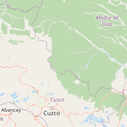
Map view of Amarakaeri Communal Reserve

Use this park location map to pinpoint Amarakaeri Communal Reserve in Peru, understand its exact geographic position, and read its mapped placement within the surrounding landscape more clearly.

Pigeon | © OpenStreetMap contributors

Location context for Amarakaeri Communal Reserve

Madre de Dios Region
Recorded earthquake history

Explore the Historical Earthquake Record for Amarakaeri Communal Reserve

Review documented seismic events near the Amarakaeri Communal Reserve through a structured geographic lens. This catalogue allows for the examination of historical earthquake records in the Madre de Dios region, providing data on event timing, magnitude, and proximity for researchers and those interested in regional geography via MoriAtlas.

Amarakaeri Communal Reserve Earthquake History

Catalogued events

28 events

Strongest magnitude

Magnitude 5.2

Most recent event

Feb 11, 2026

This history includes earthquakes recorded inside the park or within 50 km of its borders

Park atlas

Compare regional Amazonian rainforest reserves and sub-Andean transition zones

Explore Parks Near Amarakaeri Communal Reserve and Surrounding Protected Landscapes

Browse other protected areas sharing similar lowland forest ecosystems and Andean foothills terrain across the surrounding region. Continue geographic comparison by examining related conservation landscapes and regional park boundaries.
National parkMadre de Dios Region
4.9 km away#1 closest

Northwest

Manu National Park: A National Park with Mapped Boundaries in Madre de Dios Region

Explore its protected landscape and regional geography.

Gain a detailed understanding of Manu National Park, a key protected area situated in Peru's Madre de Dios Region. This page offers in-depth information on its geographic context, allowing for focused exploration of its mapped terrain and its identity as a national park. Understand how this protected landscape contributes to the regional geography and provides a solid anchor for atlas-based research and discovery.

Area
17,162.9 km²
Established
1973
IUCN
II
Relief
Mixed relief
National parkPeru
39 km away#2 closest

East

Bahuaja-Sonene National Park: A Major Amazon Frontier National Park in Peru's Geography

Explore its mapped protected landscape and diverse terrain.

Bahuaja-Sonene National Park is an extensive national park situated on the Amazon frontier in southern Peru, encompassing a crucial transition zone between lowland rainforest and higher-elevation forest ecosystems. Its diverse topography, from river valleys to mountainous slopes, creates varied natural landscapes. The park's protected boundaries are integral to the regional conservation strategy, offering a unique lens through which to study the mapped geography and ecological significance of this vast Amazonian protected area.

Area
10,914.2 km²
Established
1996
IUCN
II
Relief
Mixed relief
National parkPeru
83 km away#3 closest

North

Alto Purús National Park: Peru's Protected National Park Landscape

Mapped boundaries and regional geographic context.

Investigate Alto Purús National Park, a designated national park within Peru. This detailed page provides essential context for understanding the park's geographic location, its protected status, and its role within the broader landscape of western South America. Explore the mapped features and regional setting that define this important conservation area.

Area
25,106.9 km²
Established
2004
IUCN
II
Relief
Mixed relief
National parkLa Paz Department
178 km away#4 closest

East

Madidi National Park: National Park Protected Landscape and Geographic Atlas Entry

Explore mapped boundaries and regional context in La Paz Department.

Madidi National Park is a designated national park situated in Bolivia's La Paz Department. This detail entry offers a focused perspective on its protected landscape, its specific geographic setting, and its role within the larger atlas of natural areas. Understand the park's mapped boundaries and its contribution to the regional geography, providing a foundation for structured discovery of Bolivia's protected lands.

Area
18,957.5 km²
Established
1995
IUCN
II
Relief
Mixed relief
A minimalist watercolor painting depicting a soft green landscape with rolling hills in the background and a flat, grassy foreground.
Wildlife reservePando Department
183 km away#5 closest

East

Reserva nacional de vida silvestre amazónica Manuripi: Protected Amazonian Wilderness

Map and geographic context of Pando Department wildlife reserves

Spanning over 700,000 hectares, this wildlife reserve safeguards representative Amazonian ecosystems. Explore the hydrological network of the Madre de Dios and Manuripi river basins, ancient Brazil nut stands, and diverse wetland formations that define this significant regional protected area.

Area
7,470 km²
Established
1973
Relief
Lowland
Climate
Tropical
National parkPeru
224 km away#6 closest

Northwest

Otishi National Park: A Protected National Park Landscape in Peru's Geography

Explore the mapped boundaries and regional landscape of Otishi National Park.

Otishi National Park represents a significant protected area within Peru, offering a unique lens through which to explore regional geography and conservation landscapes. As a designated national park, it highlights the mapped boundaries and the natural terrain that defines this part of South America. Understanding Otishi National Park provides essential context for regional park discovery and the broader atlas of protected lands in Peru.

Area
3,059.73 km²
Established
2003
IUCN
II
Relief
Mountain
A panoramic watercolor illustration of a mountain landscape with rolling green hills, pink distant peaks, and small green bushes in the foreground.
Protected areaBolivia
About 293 km away#7 closest

Southeast

Área Natural de Manejo Integrado Apolobamba: Protected Landscape Geography and Andean Terrain

High-altitude glacial geography and Andean-Amazonian transition zones

Located in the department of La Paz, this protected area features a rugged landscape defined by tectonic uplift and Quaternary glaciation. It safeguards critical high-Andean habitats, including peatlands and Polylepis woodlands, while providing a essential refuge for vicuña populations within its steeply dissected mountain topography.

Area
4,837.43 km²
Established
1972
Relief
Mountain
Climate
Alpine
Protected areaBeni Department
About 383 km away#8 closest

East

Área Protegida Municipal Rhukanrhuka: Mapping Amazonian Biodiversity and Riverine Terrain

A transitional protected landscape in the Beni Department of Bolivia

Spanning a vast transition from Andean slopes to the Llanos de Moxos floodplain, Área Protegida Municipal Rhukanrhuka protects a dynamic mosaic of white-water rivers, gallery forests, and tectonic lakes. This significant municipal reserve serves as a refuge for threatened species and sustains indigenous Maropa communities within its borders, anchoring an essential conservation corridor in the northern Amazon.

Area
8,594.51 km²
Established
2019
Relief
Lowland
Climate
Tropical

Common questions about visiting, size, designation, and location context for Amarakaeri Communal Reserve

Amarakaeri Communal Reserve FAQs for park facts, access, geography, and protected area context

Find quick answers about Amarakaeri Communal Reserve, including protected-area facts, park geography, trail and visitor context, and how the park fits into its surrounding country and regional landscape.
MoriAtlas Explorer

Continue Your Protected Areas Search Across the Global Atlas

Deepen your exploration by continuing the structured search for national parks and protected areas worldwide. Utilize the comprehensive filtering capabilities to compare different conservation landscapes and refine your understanding of global park geography. Discover more about the distribution and characteristics of protected natural areas.

Global natural geography