
Rivers
Park geography
Analyzing the volcanic terrain, mountain peaks, and regional landscape context
Comprehensive Geographic Profile and Mapped Boundaries of Aso-Kujū National Park
This geographic profile details the 726.78 square kilometer extent of Aso-Kujū National Park, showcasing its complex volcanic landscape and primary peaks. The data includes mountain formations, interior waterfalls, and regional placement within Ōita and Kumamoto prefectures on the island of Kyūshū.
Related tags
volcanic landscapecalderaactive volcanomountain parkshot springs
Japan's largest volcanic caldera and mountain landscape in central Kyūshū
Aso-Kujū National Park
Aso-Kujū National Park is a protected area spanning the borderlands of Kumamoto and Ōita Prefectures in central Kyūshū, Japan. The park encompasses a dramatic volcanic landscape centered on Mount Aso, the largest active volcano in Japan and one of the largest caldera volcanoes in the world. The name combines Aso from the central volcano and Kujū from the northern mountain range, reflecting the park's dual identity as both a volcanic wonder and a mountainous wilderness area. Established in 1934 as one of Japan's earliest national parks, the area was renamed in 1986 to reflect the full extent of the protected territory. The park covers approximately 727 square kilometers of diverse terrain including volcanic plains, caldera rims, forested slopes, and alpine zones.
- Location
- Japan
- Park type
- National park
- Established
- 1934
- Area
- 726.8 km²
Location overview
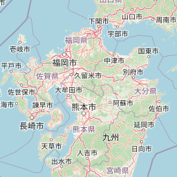
Regional mapping within Kyūshū, Kumamoto, and Ōita Prefectures
Aso-Kujū National Park Geographic Setting and Regional Atlas
Aso-Kujū National Park spans Japan and American Samoa, centering in Kyūshū across Kumamoto and Ōita Prefectures. Administrative data profiles the territory as an island park located within inland boundaries.
- Countries
- Japan
- Regions
- Kumamoto Prefecture, Kyūshū, Ōita Prefecture
- Primary location
- Ōita Prefecture
- Geographic setting
- Inland · Island
Boundary and coordinates
Visualizing the 726.78 square kilometres of protected land extent
Geographic Boundary Map of Aso-Kujū National Park
Mapped boundary geometry outlines the precise spatial shape of Aso-Kujū National Park. Accompanying metrics define the 726.78 square kilometres of land area, coordinate spans, and centre points.
- Boundary area
- 736 km²
- Boundary perimeter
- 290.5 km
- Northernmost point
- 33.3106° N
- Southernmost point
- 32.7838° N
- Easternmost point
- 131.5372° E
- Westernmost point
- 130.9191° E
- Geographic centre
- 32.9865° N, 131.1259° E
- North–south span
- 58.4 km
- East–west span
- 57.7 km
Terrain and natural features
Explore recorded peaks, rivers, and landscape classifications within the protected area
Aso-Kujū National Park Mountain Terrain and Named Natural Features
Aso-Kujū National Park is classified as a mountain park featuring diverse natural terrain and internal geographic formations. Linked feature cards supply recorded names, types, and spatial relationships for each designated landmark.
Selected named natural features
Rivers
濁川
Rivers
田町川
Waterfalls
Kakemaku
Rivers
床瀬川
Rivers
黒戸川
Environmental setting
Recorded landscape features, montane forest habitats, and temperate climate zones
Aso-Kujū National Park Environmental Setting and Physical Geography Profile
Stored classifications combine mountain relief, volcanic terrain, and partial forest cover into complementary environmental settings. Recorded categories link directly to relevant atlas destinations across the protected area.
- Relief
- Mountain
- Climate
- Temperate
- Water
- Major water bodies
- Forest cover
- Partial forest
- Seasonality
- Year-round
Landscape features
Mountains · Volcano · Rivers · Forest · Grassland · Plateau · Valleys
Habitat types
Montane forest · Grassland · Riverine habitat · Shrubland
Park atlas
Trace the regional spread of national parks and protected landscapes surrounding Aso-Kujū, comparing their unique geological and ecological features.
Explore National Parks Near Aso-Kujū: Discover Protected Areas and Volcanic Landscapes in Kyushu, Japan
Browse national parks and protected areas across Kyushu and surrounding regions, exploring diverse landscapes that offer context to Aso-Kujū National Park's active volcanic terrain. Compare the unique conservation profiles and mapped geography of these adjacent protected areas to gain a broader understanding of Japan's varied natural heritage.
National parkNagasaki Prefecture
54 km away#1 closest
West

Unzen-Amakusa National Park: Volcanic Terrain and Island Geography
Explore Nagasaki Prefecture's Protected Landscape
Unzen-Amakusa National Park represents a significant protected area within Japan's geography, characterized by the imposing presence of Mount Unzen and the distinct maritime environment of the Amakusa islands. This national park offers an opportunity to study volcanic landscapes, coastal formations, and the rich cultural history intertwined with its natural setting. Understanding its mapped boundaries and geographic context provides valuable insight into Japan's protected lands and regional landscape diversity.
- Area
- 282.79 km²
- Established
- 1934
- IUCN
- II
- Relief
- Mixed relief
National parkJapan
120 km away#2 closest
South
Kirishima-Kinkowan National Park: Exploring Japan's National Park Geography and Mapped Boundaries
A protected landscape within Japan's diverse terrain.
Kirishima-Kinkowan National Park represents a distinct protected area within Japan, offering critical insights for geographic exploration. This page details the park's specific mapped boundaries and its contribution to the regional landscape. Understanding this national park provides a structured entry point for exploring Japan's protected natural areas and their unique geographical characteristics through an atlas lens.
- Area
- 365.86 km²
- Established
- 1934
- IUCN
- II
- Relief
- Mountain
National parkJapan
About 150 km away#3 closest
East
Ashizuri-Uwakai National Park: Japan's National Park Protected Landscape
Explore the mapped geography and protected area context.
Delve into the protected landscape identity of Ashizuri-Uwakai National Park, a key national park located in Japan. This page provides essential context for understanding its mapped boundaries, its geographic placement within the Japanese archipelago, and its role as a designated protected area. It is designed to offer a structured view of the park's natural terrain and its significance for regional atlas exploration, serving as a gateway to detailed landscape context.
- Area
- 113.45 km²
- Established
- 1972
- IUCN
- II
- Relief
- Mixed relief
National parkJapan
About 195 km away#4 closest
Northeast
Setonaikai National Park: Japan's Premier Island Archipelago and Coastal Protected Landscape
Explore the unique marine geography and mapped island environments.
Setonaikai National Park is Japan's largest national park, renowned for its stunning marine environment within the Seto Inland Sea. This protected area features approximately 3,000 islands, showcasing weathered granite formations, coastal forests, and dynamic tidal phenomena like the Naruto whirlpools. The park offers a unique atlas-style exploration of island geography, coastal landscapes, and significant cultural sites, making it a cornerstone of Japan's protected natural heritage.
- Area
- 669.34 km²
- Established
- 1934
- IUCN
- II
- Visitors
- 40.6M annual
National parkNagasaki Prefecture
About 218 km away#5 closest
West
Saikai National Park: Japan National Park Geography and Protected Area Mapping
Explore Nagasaki Prefecture's protected natural landscapes.
Delve into the detailed geographic information and protected area context of Saikai National Park. As a national park situated in Nagasaki Prefecture, it represents a key area for understanding Japan's regional geography and its network of protected lands. This entry facilitates atlas-based discovery of the park's boundaries, its terrain, and its unique role within the mapped landscape of Kyushu.
- Area
- 246.46 km²
- Established
- 1955
- IUCN
- II
- Visitors
- 4.6M annual
National parkKagoshima Prefecture
266 km away#6 closest
South
Yakushima National Park: Ancient Cedar Forests and Volcanic Mountain Landscape
Discover the mapped boundaries and protected area geography.
Yakushima National Park, situated in Kagoshima Prefecture, is a prime example of protected island geography, renowned for its ancient yakusugi cedar trees and dramatic mountainous terrain. The park's protected status covers over 32,000 hectares, featuring peaks over 1,900 meters and significant biodiversity. This atlas-focused entry helps users grasp the park's unique landscape context, its position within Japan's protected areas, and the essence of its natural environment for geographic exploration.
- Area
- 325.53 km²
- Established
- 2012
- IUCN
- II
- Relief
- Mountain
National parkSouth Korea
318 km away#7 closest
West

Dadohaehaesang National Park: Exploring South Korea's Coastal Protected Area Boundaries
Mapped landscape context and regional geography.
Delve into the protected landscape of Dadohaehaesang National Park, a significant national park located in South Korea. This entry provides critical geographic information, detailing the park's mapped boundaries and its place within the broader regional terrain. It serves as an essential resource for understanding the park's protected status and its unique natural features for those exploring national parks and protected areas within an atlas framework.
- Area
- 2,321.5 km²
- Established
- 1981
- IUCN
- II
- Visitors
- 560K annual
National parkChūgoku region
About 318 km away#8 closest
Northeast
Daisen-Oki National Park: A National Park within the Chūgoku Region's Protected Landscape Atlas
Mapped geography and protected land context.
Gain a structured understanding of Daisen-Oki National Park, a designated national park situated in Japan's Chūgoku region. This entry focuses on its precise geographic location, mapped protected boundaries, and its role within a broader landscape atlas. Explore the fundamental geographic characteristics that define this key natural area, providing essential context for regional and national park discovery.
- Area
- 694.105 km²
- Established
- 1936
- IUCN
- II
- Visitors
- 9.3M annual
MoriAtlas Explorer
Continue Exploring Aso-Kujū National Park's Geographic Atlas
Deepen your understanding of Aso-Kujū National Park's protected landscape by exploring its mapped boundaries and regional geographic context. This destination within MoriAtlas offers a structured gateway to appreciating the natural terrain and protected area significance. Continue your atlas journey to uncover the intricate details of this important natural landscape.
Browse next
Global natural geography
Explore related park routes
Explore MoriAtlas Global ParksBrowse All MoriAtlas ParksGlobal Park Map DiscoveryMoriAtlas: Browse All CountriesBrowse All MoriAtlas ContinentsNational Park Environment AtlasGrand Canyon National Park AtlasYellowstone National Park AtlasYosemite National Park Atlas and GeographySerengeti National Park AtlasGalápagos National Park Protected LandscapeBanff National Park Geography and AtlasKruger National Park Atlas EntryUluṟu-Kata Tjuṯa National Park AtlasExplore Uluru-Kata Tjuta National Park GeographyPlitvice Lakes National Park AtlasFiordland National Park Protected LandscapeGreat Smoky Mountains National Park AtlasAfghanistan National Parks and Protected AreasAlbania National Parks and Protected AreasAlgeria National Parks and Protected AreasAmerican Samoa National Parks and Protected AreasAndorra National Parks and Protected AreasAngola National Parks and Protected AreasAntarctica National Parks and Protected AreasAntigua and Barbuda Park List