

Mori Atlas logo
National parkAso-Kujū National Park

Discover the mapped boundaries and regional atlas details of this significant Japanese national park.

Aso-Kujū National Park: Protected Landscape and Geographic Context in Ōita Prefecture

Aso-Kujū National Park stands as a protected national park within Ōita Prefecture, offering a unique geographic focal point for atlas-based exploration. This entry details the park's mapped landscape and its place within the regional geography, providing a structured foundation for understanding protected natural areas in Japan. Engage with detailed geographic context to appreciate the conserved terrain and its atlas significance.

volcanic landscapecalderaactive volcanomountain parkshot springsKyūshū

Aso-Kujū National Park

National park

Park overview

Structured park overview, official facts, and landscape profile for Aso-Kujū National Park

Aso-Kujū National Park park facts, protected area profile, and essential visitor context
Review the core facts for Aso-Kujū National Park, including designation, size, terrain, visitor scale, habitats, and operating context in one park-focused overview.

About Aso-Kujū National Park

Aso-Kujū National Park occupies a remarkable position in central Kyūshū, protecting a landscape shaped by millennia of volcanic activity. The park's heart belongs to Mount Aso, an active volcano whose massive caldera spans roughly 24 kilometers north to south and 18 kilometers east to west, creating one of the world's most impressive volcanic amphitheaters. Within this caldera lies an inner crater system and the active Naka-dake cone, which continues to exhibit volcanic activity and emits volcanic gases. The park extends northward to encompass the Kujū mountains, a range of rugged peaks that provides a different but equally compelling wilderness character. The volcanic geology has created an extraordinarily diverse landscape, from the stark mineral landscapes of recent eruptions to forests that have reclaimed older volcanic slopes. The park's elevation range supports multiple ecological zones, from warm-temperate forests at lower elevations through cool-temperate zones to subalpine vegetation on the highest peaks. This topographic and ecological diversity, combined with the profound geological significance of the caldera system, makes Aso-Kujū a destination of international scientific importance as well as a treasured natural area for Japanese residents and visitors.

Quick facts and research context for Aso-Kujū National Park

Aso-Kujū National Park occupies 726.78 square kilometers across Kumamoto and Ōita Prefectures on the island of Kyūshū. The park was first established on December 4, 1934, originally named Aso National Park before receiving its current designation in 1986. Mount Aso rises from the heart of a massive caldera system estimated to have formed around 270,000 years ago through major volcanic activity. The park falls under IUCN Category II protection as a national park and is administered by Japan's Ministry of the Environment.

Park context

Deeper park guide and search-rich context for Aso-Kujū National Park

Aso-Kujū National Park history, landscape, wildlife, and travel context
Explore Aso-Kujū National Park through its history, landscape character, ecosystems, wildlife, conservation priorities, cultural context, and seasonal travel timing in a structured park guide built for atlas discovery and search intent.

Why Aso-Kujū National Park stands out

Aso-Kujū National Park is best known for its extraordinary volcanic geology, centered on Mount Aso, which contains one of the world's largest calderas. The volcano's iconic crater and the surrounding volcanic landscape represent a globally significant example of caldera formation and ongoing volcanic activity. Beyond the geological wonders, the park protects the Kujū mountain range to the north, offering hiking trails through diverse ecosystems from volcanic plains to alpine zones. The combination of active volcanic scenery, natural hot springs, and mountain wilderness makes this park one of Japan's most distinctive protected landscapes.

Aso-Kujū National Park history and protected-area timeline

The volcanic landscape that became Aso-Kujū National Park has been shaped by dramatic geological events beginning approximately 270,000 years ago when major eruptions helped form the current caldera system. Long before modern protection, the area held deep spiritual significance in Japanese culture. Aso Shrine at the base of Mount Aso is a Shinto shrine traditionally believed to have been a center of worship predating the accession of Emperor Jinmu, with the shrine complex at Ichinomiya said to have been established in 281 BC. The shrine's original location is uncertain because it was repeatedly destroyed and rebuilt near the crater of Aso-san. Modern protection began on December 4, 1934, when the area was established as Aso National Park, making it one of Japan's earliest national parks. Significant expansions occurred on September 1, 1953, when Mount Yufu, Mount Tsurumi, and Mount Takasaki in Ōita Prefecture were designated as extensions. Mount Takasaki was later separated in 1956 to become part of Seto Inland Sea National Park. The Yamanami Highway, a scenic road through the park, opened in 1964 as the Toll Road Beppu Aso Road and became free to use in 1994 following the expiration of toll collection. On September 10, 1986, the name was officially changed from Aso National Park to Aso Kujū National Park to better reflect the combined territory encompassing both the Aso caldera and the Kujū mountains.

Aso-Kujū National Park landscape and geographic character

The landscape of Aso-Kujū National Park is dominated by volcanic terrain of exceptional scale and diversity. At its center lies the massive Mount Aso caldera, a depression roughly 24 by 18 kilometers in extent that ranks among the largest calderas in the world. Within this vast caldera sits the active Naka-dake crater, a continuously evolving volcanic vent that remains active and periodically emits gases and volcanic material. The inner crater walls expose layers of volcanic rock and ash that tell the geological history of repeated eruptions. Around the caldera rim, terrain rises to form jagged peaks and dramatic cliffs, with the surrounding landscape transitioning from the stark volcanic plains of the crater floor to forested slopes and eventually the higher peaks of the Kujū mountains to the north. The Kujū range adds mountainous character to the park, with peaks reaching elevations that support different ecological communities than those found in the volcanic lowlands. Within the park boundaries, visitors encounter a striking contrast between the raw mineral surfaces of recent volcanic activity and the green forests that have established on older lava flows and ash deposits. Stream systems have carved valleys through the volcanic terrain, creating additional topographic diversity and providing water for the surrounding agricultural lands.

Aso-Kujū National Park ecosystems, habitats, and plant life

The volcanic landscape of Aso-Kujū National Park supports a surprising diversity of habitats despite the dramatic geological character of the terrain. The park spans an elevation range that supports multiple vegetation zones, from warm-temperate broadleaf forests at lower elevations through cool-temperate mixed forests to subalpine vegetation on the highest peaks. The varied topography creates numerous microhabitats, with differences in aspect, elevation, soil development, and moisture creating conditions favorable for diverse plant communities. The older volcanic slopes and the Kujū mountain range support forested areas that provide habitat for numerous species. The interaction between volcanic soil fertility and the varied topography has created a mosaic of vegetation types across the park. Because the area has been a protected national park since 1934, the ecological systems have benefited from长期 protection that has allowed natural processes to continue with minimal direct human interference in core areas.

Aso-Kujū National Park wildlife and species highlights

The diverse habitats within Aso-Kujū National Park support a range of wildlife species adapted to the various ecological zones present in the park. The forested areas of the Kujū mountains and the older volcanic slopes provide habitat for mammals including various species of deer and smaller mammals that inhabit the forest understory and open areas. Birdlife is particularly notable in the park, with species ranging from forest-dwelling songbirds to birds of prey that soar on the thermal currents generated by the volcanic terrain. The open grasslands of the volcanic plains and caldera floor provide habitat for different species than those found in the forest zones, supporting bird species that prefer more open terrain. The park's protection status and long history as a national park have helped maintain wildlife populations and the ecological connections between different habitat types within the protected boundary.

Aso-Kujū National Park conservation status and protection priorities

Aso-Kujū National Park holds significant conservation value as one of Japan's oldest and most geologically important protected areas. The park protects an extraordinary volcanic landscape that represents a globally significant example of caldera formation and active volcanic processes. The protection of Mount Aso and its caldera system ensures that this remarkable geological feature remains intact for scientific study, environmental education, and natural heritage preservation. The establishment of the park in 1934 reflected early recognition of the need to protect Japan's most outstanding natural landscapes, and the subsequent expansion to include the Kujū mountains and extensions in Ōita Prefecture demonstrated growing understanding of the broader ecological and scenic values of the region. As an IUCN Category II protected area, the park is managed primarily for ecosystem protection and recreation while allowing sustainable use of certain areas. The long-standing protection has allowed natural processes to continue in much of the park while providing opportunities for people to experience and appreciate this remarkable volcanic landscape.

Aso-Kujū National Park cultural meaning and human context

Aso-Kujū National Park exists within a landscape of deep cultural significance that predates modern protection. The volcanic terrain of Mount Aso has been a site of spiritual importance in Japanese religious tradition for centuries. Aso Shrine, located at the base of the mountain, is traditionally considered one of the oldest centers of worship in Japan, with historical accounts suggesting establishment in 281 BC and connections to the legendary Emperor Jinmu. The shrine has been destroyed and rebuilt multiple times due to volcanic activity, reflecting the ongoing relationship between the local community and the active volcano. The surrounding agricultural landscape, particularly the rice paddies and vegetable farms of Kumamoto Prefecture that are irrigated by water from the Shirakawa River flowing from the park, represents centuries of human settlement and land use that has shaped the regional cultural identity. The park encompasses areas within multiple municipalities on Kyūshū, each with their own local traditions and connections to the land.

Top sights and standout views in Aso-Kujū National Park

The defining highlight of Aso-Kujū National Park is the extraordinary volcanic landscape centered on Mount Aso, whose massive caldera ranks among the world's largest and whose active Naka-dake crater provides ongoing demonstration of natural volcanic processes. The park offers visitors the rare opportunity to witness an active volcanic environment within a protected natural area, with viewpoints allowing observation of the crater and caldera landscape. The Kujū mountain range to the north provides contrasting mountain scenery and additional hiking opportunities through forests and alpine zones. Natural hot springs, particularly at Sujiyu Onsen, allow visitors to experience the geothermal activity that accompanies the volcanic setting. The network of hiking and biking trails throughout the park enables exploration of the diverse landscapes, while established campgrounds provide opportunities for longer stays. The Yamanami Highway offers a scenic driving route through the park with access to multiple areas of interest.

Best time to visit Aso-Kujū National Park

The best time to visit Aso-Kujū National Park depends on what visitors hope to experience, with each season offering distinct advantages. Spring and autumn generally provide the most comfortable conditions for outdoor activities, with moderate temperatures and colorful seasonal changes in the vegetation. Summer brings warmer weather but also the potential for the volcanic gases from Naka-dake to be more noticeable, particularly in the caldera area. Winter can bring snow to the higher elevations of the Kujū mountains while the lower volcanic areas remain accessible, offering a different perspective on the landscape. Visitors interested in seeing the active crater should be aware that volcanic activity can affect access to certain areas, and checking current conditions before visiting is advisable. The hot springs can be enjoyed year-round, providing an opportunity to experience the park's geothermal features regardless of the season.

Park location guide

Geography guide, regional context, and park location map for Aso-Kujū National Park

Aso-Kujū National Park park geography, regions, and map view in Japan
Understand where Aso-Kujū National Park sits in Japan through a broader geographic reading of the surrounding landscape, nearby location context, and its mapped position within the national park landscape.

How Aso-Kujū National Park fits into Japan

Japan is an island nation in East Asia comprising over 14,000 islands in the Pacific Ocean. The country operates as a unitary parliamentary constitutional monarchy with Emperor Naruhito as the reigning monarch and Prime Minister Sanae Takaichi leading the government. With a population of approximately 123 million, Japan is the world's 11th most populous country and a major economic power with one of the strongest militaries, though it has constitutionally renounced its right to declare war.

Wider geography shaping Aso-Kujū National Park in Japan

Japan is an island nation in the Pacific Ocean, bordered to the west by the Sea of Japan and extending from the Sea of Okhotsk in the north to the East China Sea in the south. The Japanese archipelago lies off the northeast coast of the Asian mainland. Approximately 75% of Japan's terrain is mountainous and heavily forested, with agricultural land and urbanized populations concentrated along the eastern coastal plains. The country is divided into 47 administrative prefectures and eight traditional regions.

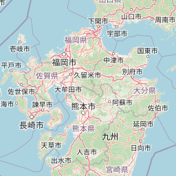
Map view of Aso-Kujū National Park

Use this park location map to pinpoint Aso-Kujū National Park in Japan, understand its exact geographic position, and read its mapped placement within the surrounding landscape more clearly.

Pigeon | © OpenStreetMap contributors

Location context for Aso-Kujū National Park

Kumamoto PrefectureKyūshūŌita Prefecture
Park atlas

Trace the regional spread of national parks and protected landscapes surrounding Aso-Kujū, comparing their unique geological and ecological features.

Explore National Parks Near Aso-Kujū: Discover Protected Areas and Volcanic Landscapes in Kyushu, Japan
Browse national parks and protected areas across Kyushu and surrounding regions, exploring diverse landscapes that offer context to Aso-Kujū National Park's active volcanic terrain. Compare the unique conservation profiles and mapped geography of these adjacent protected areas to gain a broader understanding of Japan's varied natural heritage.
National parkNagasaki Prefecture

Unzen-Amakusa National Park: Volcanic Terrain and Island Geography

Explore Nagasaki Prefecture's Protected Landscape

Unzen-Amakusa National Park represents a significant protected area within Japan's geography, characterized by the imposing presence of Mount Unzen and the distinct maritime environment of the Amakusa islands. This national park offers an opportunity to study volcanic landscapes, coastal formations, and the rich cultural history intertwined with its natural setting. Understanding its mapped boundaries and geographic context provides valuable insight into Japan's protected lands and regional landscape diversity.

Area
282.79 km²
Established
1934
IUCN
II
Relief
Mixed relief
National parkJapan

Kirishima-Kinkowan National Park: Exploring Japan's National Park Geography and Mapped Boundaries

A protected landscape within Japan's diverse terrain.

Kirishima-Kinkowan National Park represents a distinct protected area within Japan, offering critical insights for geographic exploration. This page details the park's specific mapped boundaries and its contribution to the regional landscape. Understanding this national park provides a structured entry point for exploring Japan's protected natural areas and their unique geographical characteristics through an atlas lens.

Area
365.86 km²
Established
1934
IUCN
II
Relief
Mountain
National parkJapan

Ashizuri-Uwakai National Park: Japan's National Park Protected Landscape

Explore the mapped geography and protected area context.

Delve into the protected landscape identity of Ashizuri-Uwakai National Park, a key national park located in Japan. This page provides essential context for understanding its mapped boundaries, its geographic placement within the Japanese archipelago, and its role as a designated protected area. It is designed to offer a structured view of the park's natural terrain and its significance for regional atlas exploration, serving as a gateway to detailed landscape context.

Area
113.45 km²
Established
1972
IUCN
II
Relief
Mixed relief
National parkNagasaki Prefecture

Saikai National Park: Japan National Park Geography and Protected Area Mapping

Explore Nagasaki Prefecture's protected natural landscapes.

Delve into the detailed geographic information and protected area context of Saikai National Park. As a national park situated in Nagasaki Prefecture, it represents a key area for understanding Japan's regional geography and its network of protected lands. This entry facilitates atlas-based discovery of the park's boundaries, its terrain, and its unique role within the mapped landscape of Kyushu.

Area
246.46 km²
Established
1955
IUCN
II
Visitors
4.6M annual
National parkJapan

Setonaikai National Park: Japan's Premier Island Archipelago and Coastal Protected Landscape

Explore the unique marine geography and mapped island environments.

Setonaikai National Park is Japan's largest national park, renowned for its stunning marine environment within the Seto Inland Sea. This protected area features approximately 3,000 islands, showcasing weathered granite formations, coastal forests, and dynamic tidal phenomena like the Naruto whirlpools. The park offers a unique atlas-style exploration of island geography, coastal landscapes, and significant cultural sites, making it a cornerstone of Japan's protected natural heritage.

Area
669.34 km²
Established
1934
IUCN
II
Visitors
40.6M annual
National parkKagoshima Prefecture

Yakushima National Park: Ancient Cedar Forests and Volcanic Mountain Landscape

Discover the mapped boundaries and protected area geography.

Yakushima National Park, situated in Kagoshima Prefecture, is a prime example of protected island geography, renowned for its ancient yakusugi cedar trees and dramatic mountainous terrain. The park's protected status covers over 32,000 hectares, featuring peaks over 1,900 meters and significant biodiversity. This atlas-focused entry helps users grasp the park's unique landscape context, its position within Japan's protected areas, and the essence of its natural environment for geographic exploration.

Area
325.53 km²
Established
2012
IUCN
II
Relief
Mountain
National parkSouth Korea

Hallyeohaesang National Park: South Korea National Park Geographic Atlas Entry

Explore mapped protected area boundaries and natural terrain.

As a designated national park in South Korea, Hallyeohaesang National Park offers a distinct geographic profile crucial for atlas exploration. This entry focuses on its protected landscape features, mapped territorial extent, and regional context within the Republic of Korea. Understand the park's specific geographical markers and its significance as a mapped protected area.

Area
545.63 km²
Established
1968
IUCN
II
Access
Access unknown
National parkNorth Gyeongsang Province

Gyeongju National Park: National Park Protected Landscape in North Gyeongsang Province

Mapped boundaries and regional geographic context.

Gyeongju National Park serves as a significant protected area within North Gyeongsang Province, offering a distinct national park identity. This entry focuses on its geographical significance, detailing its mapped boundaries and providing essential context for atlas exploration. Understand how this protected landscape fits within the broader regional geography and discover its place in the structured mapping of South Korea's natural heritage.

Area
137.09 km²
Established
1968
IUCN
II
Relief
Mixed relief

Common questions about visiting, size, designation, and location context for Aso-Kujū National Park

Aso-Kujū National Park FAQs for park facts, access, geography, and protected area context
Find quick answers about Aso-Kujū National Park, including protected-area facts, park geography, trail and visitor context, and how the park fits into its surrounding country and regional landscape.
MoriAtlas Explorer

Continue Your Protected Areas Search Across the Global Atlas

Deepen your exploration by continuing the structured search for national parks and protected areas worldwide. Utilize the comprehensive filtering capabilities to compare different conservation landscapes and refine your understanding of global park geography. Discover more about the distribution and characteristics of protected natural areas.

Global natural geography