

Mori Atlas logo
National parkBakossi National Park

Discover the mapped landscape and protected boundaries of this key national park in Central Africa.

Bakossi National Park: National Park Protected Area and Geographic Context in Cameroon

Bakossi National Park stands as a significant protected area within Cameroon, offering a distinct national park experience. This MoriAtlas entry details its geographic setting and protected landscape identity, providing essential context for understanding its role within the broader atlas of natural areas. Explore the mapped boundaries and regional terrain to appreciate its unique place in Cameroon's diverse geography.

Cloud ForestSubmontane ForestPlant DiversityEndemic SpeciesVolcanic MountainsCameroon Highlands

Bakossi National Park

National park

Park overview

Structured park overview, official facts, and landscape profile for Bakossi National Park

Bakossi National Park park facts, protected area profile, and essential visitor context
Review the core facts for Bakossi National Park, including designation, size, terrain, visitor scale, habitats, and operating context in one park-focused overview.

About Bakossi National Park

Bakossi National Park protects a critical highland forest ecosystem in the southwestern region of Cameroon. The park is situated within the Bakossi Mountains, a volcanic mountain range forming part of the Cameroon Line that runs inland from Mount Cameroon in a northeasterly direction. The mountains cover approximately 230,000 square kilometers and feature elevations ranging from 800 meters to 2,064 meters at Mount Kupe, the highest peak in the range. The park was formally established in 2008 following years of consultation involving local communities, conservation organizations including the World Wildlife Fund and San Diego Zoo's Center for Conservation and Research for Endangered Species. Over eighty villages participated in the gazettement process and signed legislative support for the park's creation. The creation of Bakossi National Park was unusual in the region because the primary justification centered on preserving plant diversity rather than wildlife or scenic value. The park forms part of a larger conservation landscape that includes the proposed Muanenguba ecological reserve to the east and Kupe ecological reserve to the south.

Quick facts and research context for Bakossi National Park

Bakossi National Park lies in the Cameroon Highlands ecoregion of southwestern Cameroon, spanning elevations from approximately 800 meters to 2,064 meters at Mount Kupe. The park was established by government decree in early 2008, covering 29,320 hectares within the larger Bakossi Forest Reserve. The region experiences a tropical highland climate with a dry season from November to March and rainy season from April to October, with annual rainfall between 3 and 4 meters. The area contains the largest cloud forest ecosystem in West-Central Africa. Botanical surveys between 1995 and 2005 documented 2,440 plant species, with roughly one in ten being new to science, including 82 species strictly endemic to this area.

Park context

Deeper park guide and search-rich context for Bakossi National Park

Bakossi National Park history, landscape, wildlife, and travel context
Explore Bakossi National Park through its history, landscape character, ecosystems, wildlife, conservation priorities, cultural context, and seasonal travel timing in a structured park guide built for atlas discovery and search intent.

Why Bakossi National Park stands out

Bakossi National Park is renowned for its extraordinary plant diversity, which served as the primary justification for its protection. The park contains the largest contiguous cloud forest and submontane forest in West-Central Africa. Botanical expeditions conducted by Kew Gardens and Cameroon's National Herbarium between 1995 and 2005 documented 2,440 plant species, of which approximately one in ten was previously unknown to science. The discovery of Kupea martinetugei, a completely new genus and tribe of saprophytic plant lacking photosynthetic tissue, represents one of the most botanically significant finds. The area also supports important populations of large mammals including the drill, African forest elephant, chimpanzee, and Preuss's red colobus, concentrated primarily in the northern and southern portions of the park.

Bakossi National Park history and protected-area timeline

The establishment of Bakossi National Park resulted from a prolonged consultation process beginning in the early 2000s. A field consultation program for the park's gazetting was completed in 2004, jointly supported by the World Wildlife Fund's Coastal Forests Programme and the San Diego Zoo's Center for Conservation and Research for Endangered Species. Local communities were actively involved throughout the process, with over eighty villages signing legislative support for the park's creation. Boundary adjustments and rules to preserve the legal rights of communities were recommended during this period. After some delays, the park was officially created in 2007 and inaugurated in early 2008 through a decree signed by Prime Minister Ephraim Inoni and Minister of Forests Elvis Ngollengolle. The park's creation was notably influenced by the December 2007 release of the film "The Mists of Mwanenguba," which documented conservation importance in the Bakossi mountains and was viewed by the Minister of Forests and the Paramount Chief of Bakossi in January 2008. Following establishment, WWF Sweden increased funding for the area and developed strategies for conservation-based income-generating activities for local communities.

Bakossi National Park landscape and geographic character

The Bakossi Mountains form a dramatic volcanic landscape rising steeply from the surrounding lowlands of southwestern Cameroon. The terrain features steep slopes and deep valleys created by erosion from the abundant seasonal rainfall, with elevations ranging from approximately 800 meters in the lower reaches to 2,064 meters at Mount Kupe, the highest peak. The mountain slopes are primarily covered by fertile volcanic soils that support dense forest growth. The landscape includes the national park itself as well as adjacent proposed ecological reserves at Muanenguba to the east and Kupe to the south, forming a contiguous highland forest complex. The region's topography creates multiple distinct habitat zones as elevation increases, from submontane forest at lower elevations up to higher altitude forest communities near the peaks. The area experiences a tropical highland climate characterized by high humidity between 70 and 85 percent, temperatures ranging from 22 to 32 degrees Celsius, and annual rainfall between 3 and 4 meters.

Bakossi National Park ecosystems, habitats, and plant life

The Bakossi region is recognized as one of the most botanically significant areas in Africa, forming part of the Cameroon Highlands ecoregion. The diverse elevational gradient supports a wide range of habitats that create exceptional plant species richness. Botanical surveys conducted between 1995 and 2005 by Kew Gardens and the IRAD-National Herbarium of Cameroon documented 2,440 plant species in the Kupe-Bakossi region, a remarkably high number for the area. Of these species, approximately one in ten was found to be new to science, representing a extraordinary discovery rate. Eighty-two species are strictly restricted to this area, found nowhere else on Earth, while 232 species are threatened with extinction according to IUCN criteria. The cloud forest and submontane forest communities represent what may be the largest continuous area of such forest types in West-Central Africa. The discovery of Kupea martinetugei, a completely new genus and tribe within the Triuridaceae family, stands as particularly significant as it represents a saprophytic plant completely lacking photosynthetic tissue and is critically endangered, known only from two tiny sites within the park.

Bakossi National Park wildlife and species highlights

Bakossi National Park supports important populations of large mammals that represent significant conservation value for Central Africa. The park is home to the drill, a large African primate listed as vulnerable and found primarily in the forest regions of Cameroon and Nigeria. African forest elephants, a smaller and less studied cousin of the savanna elephant, inhabit the park's forested areas. Chimpanzees are present throughout the park, and Preuss's red colobus, a critically endangered primate subspecies, occupies specific forest habitats. WWF has conducted geospatial mapping of these key large mammal species, finding they are concentrated primarily in the northern and southern portions of the park, likely due to greater food availability, better shelter, and lower levels of hunting and farmland encroachment in these areas. The park's wildlife faces pressures from bushmeat hunting, which a 2003 report indicated had reached unsustainable levels and posed significant risks to large mammal populations.

Bakossi National Park conservation status and protection priorities

Bakossi National Park represents a critical conservation priority due to its exceptional plant diversity and the presence of numerous endemic and threatened species. The park's establishment in 2008 was uniquely justified on the basis of plant conservation, distinguishing it from most other national parks in Central Africa. The discovery that approximately one in ten plant species in the area was new to science, along with 82 strictly endemic species and 232 threatened species, demonstrates the global significance of this highland forest ecosystem. Conservation organizations including WWF and Kew Gardens have been actively involved in research and management. However, the park faces significant threats including population growth, unsustainable bushmeat hunting, agricultural encroachment, and proposed large-scale oil palm plantation development. Local communities have taken leadership roles in protecting the forest from illegal logging, partly motivated by traditional beliefs that preserve certain sacred forest areas with significantly higher plant diversity than surrounding areas.

Bakossi National Park cultural meaning and human context

The Bakossi region is primarily inhabited by the Bakossi people, alongside Mbo, Manehas, Bakem, Baneka communities, and immigrant Bamiliki populations. These communities have historically practiced small-scale logging for construction and furniture-making, along with harvesting forest plants for various uses. Cash crop agriculture focuses on cocoa and coffee, while food crops include plantain, cocoyam, cassava, beans, and pepper. Traditional beliefs have played a significant role in forest preservation, as sacred forests and groves within the national park demonstrate significantly higher plant species diversity than adjacent areas. Over eighty villages participated in the consultation process leading to the park's creation, and community involvement remains essential to conservation success. However, economic pressures including declines in coffee and cocoa prices have increased reliance on nontimber forest products, creating additional pressure on the forest ecosystem.

Top sights and standout views in Bakossi National Park

Bakossi National Park protects the largest cloud forest ecosystem in West-Central Africa and contains exceptional plant species richness with numerous endemic and scientifically significant discoveries. The park's establishment in 2008 was primarily justified by plant conservation, making it unusual among Central African protected areas. Botanical surveys documented 2,440 plant species, including the remarkable discovery of Kupea martinetugei, a completely new genus and tribe of saprophytic plant lacking chlorophyll. The park supports important populations of large mammals including drills, African forest elephants, chimpanzees, and Preuss's red colobus. The landscape features Mount Kupe rising to 2,064 meters within the volcanic Cameroon Line, creating diverse elevational habitats. Community involvement in conservation has been extensive, with over eighty villages participating in the park's creation.

Best time to visit Bakossi National Park

The Bakossi region experiences a tropical highland climate with distinct dry and rainy seasons that influence visit conditions. The dry season from November through March typically offers more accessible trail conditions and clearer visibility for landscape viewing, though mist and cloud remain common in the highland forest. The rainy season from April to October brings heavier precipitation and creates lush forest conditions, but trails may be more challenging and some areas less accessible. Temperature ranges from 22 to 32 degrees Celsius year-round, with high humidity between 70 and 85 percent. The wettest month is August, while January is typically the hottest month. Visitors interested in botanical exploration may find the post-rainy season period valuable for observing flowering patterns, though wildlife viewing can be productive during drier periods when animals concentrate around water sources.
Park location guide

Geography guide, regional context, and park location map for Bakossi National Park

Bakossi National Park park geography, regions, and map view in Cameroon
Understand where Bakossi National Park sits in Cameroon through a broader geographic reading of the surrounding landscape, nearby location context, and its mapped position within the national park landscape.

How Bakossi National Park fits into Cameroon

Cameroon is a Central African country spanning coastal, highland, and forest regions. It has a population of nearly 31 million people who speak 250 native languages alongside English and French as official languages. The country gained independence from France in 1960 and unified with British Southern Cameroons in 1961.

Wider geography shaping Bakossi National Park in Cameroon

Cameroon is located in Central Africa, bordering Nigeria and Chad to the west and north, the Central African Republic to the east, and Equatorial Guinea, Gabon, and the Republic of the Congo to the south. The country has a coastline on the Bight of Biafra, part of the Gulf of Guinea. Terrain includes coastal plains, mountainous highlands (including Mount Cameroon), plateaus, and dense rainforest regions.

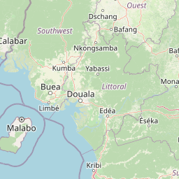
Map view of Bakossi National Park

Use this park location map to pinpoint Bakossi National Park in Cameroon, understand its exact geographic position, and read its mapped placement within the surrounding landscape more clearly.

Pigeon | © OpenStreetMap contributors
Park atlas

Map the surrounding protected landscapes of Cameroon, comparing cloud forests, volcanic mountains, and unique biodiversity beyond Bakossi National Park.

Discover Other National Parks and Protected Areas Near Bakossi National Park in the Cameroon Highlands
Explore additional national parks and protected areas across the Cameroon highlands, tracing similar cloud forest ecosystems and volcanic mountain landscapes adjacent to Bakossi National Park. Comparing these distinct conservation landscapes provides valuable geographic context, allowing for deeper atlas-style discovery of West-Central Africa's extraordinary biodiversity and varied terrain.
Watercolor illustration of a forested landscape with pink flowering plants, a winding river, and mountain ranges in the background
National park

Korup National Park: Cameroon's Ancient Tropical Rainforest Protected Area Exploration

Explore its rich biodiversity and unique geographic landscape.

Korup National Park is a significant protected area in Cameroon, covering 1,260 square kilometers of what is considered one of Africa's oldest and most biodiverse tropical rainforests. Established in 1986, this national park is renowned for its exceptional primate populations, extensive plant species, and its role as a critical conservation landscape. The park's terrain transitions from lowlands to hilly areas, with a dense network of streams, offering a rich subject for geographic and protected-area study.

Area
1,260 km²
Established
1986
IUCN
II
Relief
Mixed relief
National park

Douala-Edéa National Park: Coastal Mangrove and Tropical Forest Protected Landscape

Explore Cameroon's vital protected national park geography.

Douala-Edéa National Park is a protected national park in Cameroon's Littoral Region, defined by its extensive coastal geography where tropical lowland equatorial forests merge with significant Atlantic mangrove ecosystems. This area, encompassing roughly 2,715 square kilometers along the Bight of Biafra and the Sanaga River estuary, offers rich context for understanding Central Africa's coastal protected lands and diverse natural landscapes.

Area
2,715.12 km²
Established
2018
IUCN
II
Relief
Lowland
National parkBioko Norte

Pico Basilé National Park: Volcanic Peak National Park and Protected Landscape

Explore Bioko Norte's unique montane terrain and rich avifauna.

Pico Basilé National Park is a critical conservation zone encompassing Equatorial Guinea's highest point, Pico Basilé volcano. This national park protects unique montane forest ecosystems and their diverse inhabitants, including several threatened primate species and a significant bird population, making it a key protected area on Bioko Island. Understand its geographic setting within Bioko Norte and its role as a vital natural landscape.

Area
300 km²
Established
2000
IUCN
II
Relief
Mountain
National parkCentre Region

Mpem and Djim National Park: Protected Landscape and Regional Geographic Atlas

Explore the mapped terrain and protected boundaries of this national park.

Mpem and Djim National Park is a protected natural area situated within Cameroon's Centre Region. This detail entry provides an atlas-focused view, emphasizing the park's protected landscape characteristics and its position within the regional geography. Understand the mapped context and discover the identity of Mpem and Djim National Park as a key protected area.

Area
974.8 km²
Established
2004
IUCN
II
Relief
Upland
National parkCameroon

Campo Ma'an National Park: Essential Protected Landscape in Cameroon's Atlantic Biafran Forest

Mapped evergreen canopy and vital great ape habitat in a key conservation area.

Campo Ma'an National Park is a crucial protected area in Cameroon, spanning 2,680 square kilometers of dense Atlantic Biafran forest. Established for environmental compensation, it safeguards critical habitat for western lowland gorillas and central chimpanzees, alongside forest elephants and diverse birdlife. The park's landscape is defined by a persistent evergreen canopy ecosystem, offering a unique context for understanding Central African rainforest geography and protected land status.

Area
2,680 km²
Established
2000
IUCN
II
Climate
Tropical
National parkEquatorial Guinea

Monte Alén National Park National Park: Mapped Protected Landscape in Equatorial Guinea

Explore regional geography and park boundaries.

Monte Alén National Park, a designated national park in Equatorial Guinea, offers a unique focal point for understanding protected landscapes. This entry provides detailed geographic context, highlighting the park's mapped boundaries and its significance within the atlas of Central African natural terrain. Investigate the terrain and regional setting of Monte Alén National Park for structured geographic discovery.

Area
2,000 km²
Established
1990
IUCN
II
Relief
Mountain
National park

Deng Deng National Park: Protected Landscape & Gorilla Habitat in East Cameroon

Discover the mapped geography and conservation significance of this national park.

Deng Deng National Park in Cameroon's East Region offers a unique glimpse into the Northern Congolian forest-savanna mosaic ecoregion. Spanning about 683 square kilometers and shaped by the Sanaga River, it is critically important as the northernmost known habitat for western lowland gorillas. Its diverse terrain supports not only gorillas but also elephants, chimpanzees, and pangolins, highlighting its role in Central African biodiversity and regional landscape context.

Area
682.64 km²
Established
2010
IUCN
II
Climate
Tropical
National parkEquatorial Guinea

Altos de Nsork National Park: Equatorial Guinea's Protected Landscape and Map Context

Explore the mapped boundaries of this national park.

Altos de Nsork National Park stands as a designated national park within Equatorial Guinea, offering a distinct protected landscape. This entry provides essential atlas-driven details, emphasizing its geographic setting and mapped park boundaries. Understand its regional context and its significance as part of the conservation network in Central Africa, contributing to a richer understanding of mapped natural terrains.

Area
700 km²
Established
2000
IUCN
II
Relief
Highland

Common questions about visiting, size, designation, and location context for Bakossi National Park

Bakossi National Park FAQs for park facts, access, geography, and protected area context
Find quick answers about Bakossi National Park, including protected-area facts, park geography, trail and visitor context, and how the park fits into its surrounding country and regional landscape.
MoriAtlas Explorer

Continue Your Protected Areas Search Across the Global Atlas

Deepen your exploration by continuing the structured search for national parks and protected areas worldwide. Utilize the comprehensive filtering capabilities to compare different conservation landscapes and refine your understanding of global park geography. Discover more about the distribution and characteristics of protected natural areas.

Global natural geography

