

Mori Atlas logo
National parkMpem and Djim National Park

Mapping the protected area boundaries and natural terrain of Mpem and Djim National Park

Mpem and Djim National Park: Protected Landscape and Regional Geography in Centre Region

(Parc national de Mpem et Djim)

Mpem and Djim National Park represents a significant protected natural landscape within the Centre Region of Cameroon. This page offers an atlas-oriented perspective, focusing on the park's mapped boundaries and its integral place within the regional geography. Users can explore the specific geographic context and the protected-area identity of Mpem and Djim National Park.

National ParkCameroonForest-Savanna MosaicProtected AreaCentral AfricaTropical Savanna

Mpem and Djim National Park

National park

Park overview

Structured park overview, official facts, and landscape profile for Mpem and Djim National Park

Mpem and Djim National Park park facts, protected area profile, and essential visitor context
Review the core facts for Mpem and Djim National Park, including designation, size, terrain, visitor scale, habitats, and operating context in one park-focused overview.

About Mpem and Djim National Park

Mpem and Djim National Park represents one of Cameroon's significant protected areas, established in 2004 to conserve a biologically diverse landscape in the country's Central Region. The park's defining characteristic is its position within the Northern Congolian forest-savanna mosaic, a transitional ecological zone that spans across central Africa. This mosaic region creates a complex intermingling of distinct habitat types, where dense gallery forests follow river courses while savanna and woodland predominate on the intervening uplands. The park is bisected and bounded by two major river systems, the Mpem and Djim, which serve as critical water sources and habitat corridors while eventually flowing into the Sanaga River, one of Cameroon's most important drainage systems. The designation of this area as a national park reflects Cameroon's commitment to preserving its ecological diversity while maintaining the ecological connectivity that allows species movement between the Congo Basin and more northerly savanna ecosystems. Beyond its ecological value, the park contributes to regional biodiversity conservation by protecting populations of large mammals that face increasing pressure from habitat loss and hunting across central Africa.

Quick facts and research context for Mpem and Djim National Park

Mpem and Djim National Park is located in Cameroon's Centre Region, approximately 5.16°N latitude and 11.71°E longitude. The park spans 974.8 square kilometers and was officially designated as a national park in 2004 under Cameroon's protected areas framework, receiving IUCN Category II status. The Mpem and Djim rivers, from which the park takes its name, form natural boundaries along its western and eastern edges respectively, flowing southward to join the Sanaga River. The climate is tropical savanna with temperatures ranging from 22°C to 29°C and annual rainfall between 1800 and 2000 millimeters, distributed across two distinct rainy seasons.

Park context

Deeper park guide and search-rich context for Mpem and Djim National Park

Mpem and Djim National Park history, landscape, wildlife, and travel context
Explore Mpem and Djim National Park through its history, landscape character, ecosystems, wildlife, conservation priorities, cultural context, and seasonal travel timing in a structured park guide built for atlas discovery and search intent.

Why Mpem and Djim National Park stands out

Mpem and Djim National Park is best known for its position within the Northern Congolian forest-savanna mosaic, a transitional ecoregion of outstanding ecological significance. The park exemplifies the boundary zone between the humid Congo Basin forests to the south and the drier Sudanian savanna to the north, creating a complex mosaic of habitats. This ecological positioning supports remarkable biodiversity, with 79 native mammal species recorded including threatened populations of leopards, chimpanzees, hippopotamuses, and African bush elephants. The park's riverine forests harbor valuable timber species and endemic flora, while the surrounding savanna woodlands contain distinctive tree species adapted to seasonal moisture variations.

Mpem and Djim National Park history and protected-area timeline

Mpem and Djim National Park was established by the government of Cameroon in 2004, representing a relatively recent addition to the nation's protected area network. The park's creation was part of Cameroon's ongoing efforts to expand and consolidate its conservation estate during the early 2000s, a period that saw increased attention to biodiversity protection following international conventions and sustainable development priorities. The selection of this particular landscape for national park status reflected growing recognition of the ecological importance of the forest-savanna transition zone, which had previously received limited formal protection compared to the more strictly forest-covered areas of southern Cameroon or the highland regions. The park's designation also acknowledged the watershed functions of the Mpem and Djim river systems, whose protection contributes to downstream water quality and flood regulation in the broader Sanaga River basin. Since establishment, the park has been managed under Cameroon's protected areas regulatory framework, with the national park designation providing legal protection against logging, mining, and other extractive activities that could degrade its ecological integrity.

Mpem and Djim National Park landscape and geographic character

The landscape of Mpem and Djim National Park is characterized by a diverse topography shaped by the interplay of river systems and the transitional ecological zone. The terrain consists primarily of undulating upland areas interspersed with valleys formed by the Mpem and Djim rivers and their tributaries. Gallery forests line the watercourses, creating dense green corridors that contrast sharply with the more open savanna and woodland environments on the surrounding slopes. The savanna areas are dominated by grasses including Bokassa grass and Imperata cylindrica, with scattered trees such as Albizzia and Lophira providing limited canopy cover. The woodland zones contain a more diverse tree stratum, with species adapted to the seasonal climate patterns. The rivers themselves form natural boundaries that help define the park's perimeter, with the Mpem River bounding the western side and the Djim River marking the eastern edge. This riverine configuration creates a landscape of ecological gradients, where moisture availability decreases as one moves away from the watercourses toward the upland savanna. The overall visual character blends the lush greenery of riverine forest with the golden-brown tones of savanna grasslands, creating a mosaic pattern typical of transitional African landscapes.

Mpem and Djim National Park ecosystems, habitats, and plant life

The nature of Mpem and Djim National Park is defined by its position in the Northern Congolian forest-savanna mosaic, one of Africa's key ecological transition zones. This ecoregion forms a broad band of interwoven habitats where the immense Congo Basin rainforest gives way progressively to the drier Sudanian savanna belt. Within the park, this transition manifests as a patchwork of distinct habitat types: dense forest formations concentrated along the river corridors, more open woodland on the intermediate slopes, and expansive savanna grasslands covering the higher ground. The vegetation reflects this gradient, with forest areas supporting species such as Piptadeniastrum africanum, Milicia excelsa, and Pterocarpus soyauxii, while savanna trees like Albizzia and Lophira dominate the open areas. The forest understory contains characteristic species adapted to the lower light conditions, while savanna areas support an understory dominated by grasses that thrive in the seasonal climate. This ecological complexity creates conditions suitable for a wide range of plant and animal species, with the transitional nature of the environment supporting both forest-dependent organisms and species adapted to more open savanna conditions.

Mpem and Djim National Park wildlife and species highlights

The wildlife of Mpem and Djim National Park reflects the park's transitional position between forest and savanna ecosystems. Seventy-nine native mammal species have been recorded within the park's boundaries, representing a significant diversity for a protected area of this size. Large mammals of conservation concern include leopards, chimpanzees, hippopotamuses, and African bush elephants, all of which face varying levels of threat across their ranges. The chimpanzee populations represent an important component of the park's biodiversity, as these primates require forest habitat for feeding and nesting. Hippopotamuses inhabit the river systems, utilizing the Mpem and Djim for grazing and cooling activities. African bush elephants, though ranging across both forest and savanna environments, may use the park's river corridors as movement pathways through the landscape. The park also supports at least fourteen species of bats, including both forest-dwelling and savanna-adapted species, reflecting the diversity of roosting and foraging habitats available within the protected area. This assemblage of mammalian fauna, combined with the reptile, bird, and invertebrate species that occupy the various habitat types, creates a wildlife community representative of central Africa's forest-savanna transition zone.

Mpem and Djim National Park conservation status and protection priorities

Mpem and Djim National Park serves as an important conservation tool for protecting a globally significant ecological transition zone. The park's inclusion within the Northern Congolian forest-savanna mosaic, which is recognized as a Key Biodiversity Area and a Priority Ecoregion for conservation action, reflects the importance of this landscape for maintaining ecological processes and species diversity. The protected area status provides legal framework for preventing habitat conversion, controlling hunting pressure, and managing sustainable use of natural resources within its boundaries. Conservation of this landscape is particularly relevant given the broader context of forest loss and fragmentation across central Africa, as the transitional zone between Congo forest and Sudanian savanna faces increasing pressures from agricultural expansion, logging, and infrastructure development. The park also contributes to watershed protection, with the Mpem and Djim rivers feeding into the Sanaga River system that provides water resources for downstream communities and ecosystems. By protecting both forest and savanna habitats within a single protected area, Mpem and Djim National Park helps maintain the ecological connectivity that allows species to move and adapt in response to environmental changes.

Mpem and Djim National Park cultural meaning and human context

Mpem and Djim National Park is situated in Cameroon's Centre Region, an area with diverse human communities whose traditional land use practices have shaped the landscape over generations. The park's name derives from the two rivers that form its natural boundaries, reflecting the importance of these watercourses in local geography and culture. The rivers have historically provided water for agriculture, fishing, and transportation for communities in the surrounding area. While the park's establishment has restricted certain traditional uses of the land, the protected area framework in Cameroon typically acknowledges existing community rights and seeks to balance conservation objectives with sustainable livelihood needs. The Centre Region contains a mosaic of ethnic groups with varying relationships to the land, and the park's forests and savanna areas have been part of regional patterns of resource use that predate formal protected area designation. Understanding these cultural dimensions contributes to effective park management and helps ensure that conservation efforts account for the human context in which the protected area exists.

Top sights and standout views in Mpem and Djim National Park

Mpem and Djim National Park stands out as a protected area that captures the ecological richness of central Africa's forest-savanna transition. The park's gallery forests along the Mpem and Djim rivers offer opportunities to observe forest ecosystems in a landscape more typically associated with savanna environments. The presence of large mammals including elephants, hippos, leopards, and chimpanzees demonstrates the conservation value of protecting this transitional habitat. The diverse plant community, ranging from riverine forest trees like Milicia excelsa and Piptadeniastrum africanum to savanna species like Albizzia and Lophira, illustrates the ecological complexity that the park helps preserve. The wet-dry seasonal rhythm of the landscape creates dynamic conditions throughout the year, with the two rainy seasons bringing different visual characters to the savanna and influencing wildlife behavior and distribution.

Best time to visit Mpem and Djim National Park

The climate of Mpem and Djim National Park follows a tropical savanna pattern with four distinct seasons that influence the character of a visit. The long dry season from mid-November to mid-March typically offers easier movement through the landscape as vegetation is less dense and wildlife concentrates more predictably around water sources. This period coincides with cooler temperatures and lower humidity, making it generally more comfortable for field activities. The short rainy season from mid-March to end of June and the long rainy season from September to mid-November transform the landscape, with the savanna turning lush and green and watercourses flowing more fully. These periods may present challenges for travel but offer the opportunity to experience the park's ecosystems at their most verdant. The short dry season from July to August represents a transitional period between the two rainy seasons. Visitors interested in wildlife viewing might consider the dry seasons when animals are more readily observable at waterholes and river margins, while those interested in botanical features and landscape photography may find the rainy seasons more visually appealing.

Park location guide

Geography guide, regional context, and park location map for Mpem and Djim National Park

Mpem and Djim National Park park geography, regions, and map view in Cameroon
Understand where Mpem and Djim National Park sits in Cameroon through a broader geographic reading of the surrounding landscape, nearby location context, and its mapped position within the national park landscape.

How Mpem and Djim National Park fits into Cameroon

Cameroon is a Central African country spanning coastal, highland, and forest regions. It has a population of nearly 31 million people who speak 250 native languages alongside English and French as official languages. The country gained independence from France in 1960 and unified with British Southern Cameroons in 1961.

Wider geography shaping Mpem and Djim National Park in Cameroon

Cameroon is located in Central Africa, bordering Nigeria and Chad to the west and north, the Central African Republic to the east, and Equatorial Guinea, Gabon, and the Republic of the Congo to the south. The country has a coastline on the Bight of Biafra, part of the Gulf of Guinea. Terrain includes coastal plains, mountainous highlands (including Mount Cameroon), plateaus, and dense rainforest regions.

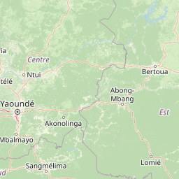
Map view of Mpem and Djim National Park

Use this park location map to pinpoint Mpem and Djim National Park in Cameroon, understand its exact geographic position, and read its mapped placement within the surrounding landscape more clearly.

Pigeon | © OpenStreetMap contributors

Location context for Mpem and Djim National Park

Centre Region
Park atlas

Explore mapped geography and protected areas within Cameroon's forest-savanna mosaic, offering regional park comparisons

Compare National Parks and Protected Landscapes Near Mpem and Djim National Park
Browse national parks and protected areas geographically linked to Mpem and Djim National Park, tracing the unique forest-savanna mosaic across Cameroon. Compare diverse protected landscapes, from riverine forests to savanna woodlands, to understand regional conservation efforts and broader geographic patterns in Central Africa.
National park

Deng Deng National Park: Protected Landscape & Gorilla Habitat in East Cameroon

Discover the mapped geography and conservation significance of this national park.

Deng Deng National Park in Cameroon's East Region offers a unique glimpse into the Northern Congolian forest-savanna mosaic ecoregion. Spanning about 683 square kilometers and shaped by the Sanaga River, it is critically important as the northernmost known habitat for western lowland gorillas. Its diverse terrain supports not only gorillas but also elephants, chimpanzees, and pangolins, highlighting its role in Central African biodiversity and regional landscape context.

Area
682.64 km²
Established
2010
IUCN
II
Climate
Tropical
National parkCameroon

Bakossi National Park: Detailed Protected Area Map and Geographic Identity in Cameroon

Explore the mapped landscape and regional context of this Cameroonian national park.

Bakossi National Park is an important protected area situated within Cameroon, functioning as a national park dedicated to conservation and geographic study. This page provides essential details on its mapped boundaries, regional setting, and the natural landscape it represents. It serves as a foundational element for understanding protected areas in Central Africa and their broader geographical significance.

Area
293.2 km²
Established
2008
Relief
Mountain
Climate
Tropical
National park

Douala-Edéa National Park: Coastal Mangrove and Tropical Forest Protected Landscape

Explore Cameroon's vital protected national park geography.

Douala-Edéa National Park is a protected national park in Cameroon's Littoral Region, defined by its extensive coastal geography where tropical lowland equatorial forests merge with significant Atlantic mangrove ecosystems. This area, encompassing roughly 2,715 square kilometers along the Bight of Biafra and the Sanaga River estuary, offers rich context for understanding Central Africa's coastal protected lands and diverse natural landscapes.

Area
2,715.12 km²
Established
2018
IUCN
II
Relief
Lowland
Watercolor illustration of a forested landscape with pink flowering plants, a winding river, and mountain ranges in the background
National park

Korup National Park: Cameroon's Ancient Tropical Rainforest Protected Area Exploration

Explore its rich biodiversity and unique geographic landscape.

Korup National Park is a significant protected area in Cameroon, covering 1,260 square kilometers of what is considered one of Africa's oldest and most biodiverse tropical rainforests. Established in 1986, this national park is renowned for its exceptional primate populations, extensive plant species, and its role as a critical conservation landscape. The park's terrain transitions from lowlands to hilly areas, with a dense network of streams, offering a rich subject for geographic and protected-area study.

Area
1,260 km²
Established
1986
IUCN
II
Relief
Mixed relief
National park

Faro National Park: Central Africa's Largest Hippo Population within Sudano-Sahelian Protected Landscape

Explore mapped boundaries and regional geography of this vital national park.

Faro National Park stands as a critical protected area within Cameroon, celebrated for its immense hippopotamus population and its role in conserving large mammals across the Sudano-Sahelian zone. The park's landscape comprises undulating savanna plains, river valleys, and elevated hilltops, offering a diverse geographic context for conservation. Its inclusion in a transboundary protected network highlights its importance for regional landscape mapping and ecological continuity. Understanding Faro National Park involves appreciating its unique habitat mosaic and its contribution to the protected areas atlas.

Area
3,418 km²
Established
1989
IUCN
II
Relief
Upland
National parkCameroon

Campo Ma'an National Park: Essential Protected Landscape in Cameroon's Atlantic Biafran Forest

Mapped evergreen canopy and vital great ape habitat in a key conservation area.

Campo Ma'an National Park is a crucial protected area in Cameroon, spanning 2,680 square kilometers of dense Atlantic Biafran forest. Established for environmental compensation, it safeguards critical habitat for western lowland gorillas and central chimpanzees, alongside forest elephants and diverse birdlife. The park's landscape is defined by a persistent evergreen canopy ecosystem, offering a unique context for understanding Central African rainforest geography and protected land status.

Area
2,680 km²
Established
2000
IUCN
II
Climate
Tropical
National parkBioko Norte

Pico Basilé National Park: Volcanic Peak National Park and Protected Landscape

Explore Bioko Norte's unique montane terrain and rich avifauna.

Pico Basilé National Park is a critical conservation zone encompassing Equatorial Guinea's highest point, Pico Basilé volcano. This national park protects unique montane forest ecosystems and their diverse inhabitants, including several threatened primate species and a significant bird population, making it a key protected area on Bioko Island. Understand its geographic setting within Bioko Norte and its role as a vital natural landscape.

Area
300 km²
Established
2000
IUCN
II
Relief
Mountain
National parkGabon

Minkébé National Park: Protected Area and Geographic Context in Gabon

Explore the mapped terrain and protected landscape of this national park.

Gain a structured understanding of Minkébé National Park, a designated national park situated in Gabon. This destination focuses on the park's protected landscape, its distinct mapped boundaries, and its contribution to the regional geography of Central Africa. Examine how its protected status shapes the natural terrain and offers a unique angle for geographic discovery.

Area
7,570 km²
Established
2002
IUCN
II
Relief
Upland

Common questions about visiting, size, designation, and location context for Mpem and Djim National Park

Mpem and Djim National Park FAQs for park facts, access, geography, and protected area context
Find quick answers about Mpem and Djim National Park, including protected-area facts, park geography, trail and visitor context, and how the park fits into its surrounding country and regional landscape.
MoriAtlas Explorer

Continue Your Protected Areas Search Across the Global Atlas

Deepen your exploration by continuing the structured search for national parks and protected areas worldwide. Utilize the comprehensive filtering capabilities to compare different conservation landscapes and refine your understanding of global park geography. Discover more about the distribution and characteristics of protected natural areas.

Global natural geography