Mori Atlas logo
National parkMinkébé National Park

Trace the mapped boundaries of this national park within Central Africa's diverse geography.

Minkébé National Park: Gabon's Protected Landscape and Regional Geography

(Parc National de Minkébé)

Minkébé National Park stands as a significant protected area within Gabon, offering a distinct focus for geographic exploration. This national park provides a unique lens through which to understand the mapped landscape and regional context of Central Africa. Discover its protected boundaries and natural terrain, anchoring its identity within Gabon's equatorial geography.

National ParkLowland ForestForest ElephantsPrimatesCentral AfricaImportant Bird Area

Minkébé National Park

National park

Park overview

Structured park overview, official facts, and landscape profile for Minkébé National Park

Minkébé National Park park facts, protected area profile, and essential visitor context
Review the core facts for Minkébé National Park, including designation, size, terrain, visitor scale, habitats, and operating context in one park-focused overview.

About Minkébé National Park

Minkébé National Park represents one of Africa's most important protected forest landscapes, situated in the remote northeastern region of Gabon near the borders with Cameroon and the Republic of the Congo. The park encompasses approximately 7,570 square kilometers of contiguous lowland tropical forest within the broader Minkébé forest complex that covers around 30,000 square kilometers in total. This vast forest ecosystem forms part of the Northwest Congolian Lowland Forest ecoregion, recognized by the World Wildlife Fund as one of its priority global ecoregions due to its exceptional biodiversity. The park's establishment in 2002 marked a significant milestone in Gabon's conservation efforts, building upon earlier recognition by the WWF in 1989 that identified the area as requiring protection. The park currently operates under the management of Gabon's National Agency for National Parks, with ongoing support from international conservation partners including the WWF, CARPE (a USAID program), UNESCO, and various European funding mechanisms.

Quick facts and research context for Minkébé National Park

Minkébé National Park spans 7,570 square kilometers in northeastern Gabon, making it one of the largest national parks in central Africa. The park was formally established in August 2002 and is managed by Gabon's National Agency for National Parks. It is recognized as a Category II protected area by IUCN and has been proposed for World Heritage status. The park sits within the Northwest Congolian Lowland Forest ecoregion, one of the most biologically diverse forest regions in Africa. Four main rivers drain through the park, creating diverse aquatic and riparian habitats.

Park context

Deeper park guide and search-rich context for Minkébé National Park

Minkébé National Park history, landscape, wildlife, and travel context
Explore Minkébé National Park through its history, landscape character, ecosystems, wildlife, conservation priorities, cultural context, and seasonal travel timing in a structured park guide built for atlas discovery and search intent.

Why Minkébé National Park stands out

Minkébé National Park is particularly renowned for its extraordinary forest elephant population, which the World Wildlife Fund considers one of the largest in Africa. The park also hosts significant populations of western lowland gorillas, chimpanzees, and mandrills, all of which are listed on the IUCN Red List. The park's biodiversity extends to numerous other species including leopards, African golden cats, giant pangolins, red river hogs, and the rare bongo and giant forest hog. Its designation as an Important Bird Area by BirdLife International reflects the presence of significant bird populations including the spot-breasted ibis and Rachel's malimbe.

Minkébé National Park history and protected-area timeline

The Minkébé region carries significant historical depth, having been inhabited by the Fang people whose cultural presence shaped the area long before its protected status. The name Minkébé itself originates from the Fang word "minkegbe," meaning valleys or ditches, a direct reference to the region's distinctive terrain. During the 1920s, the area came under French military control during the colonial period. The modern conservation movement for the region began in earnest when the WWF initiated a management program in 1997, establishing command centers at Oyem and Makokou while installing a central camp at the mouth of the Nouna River. The park was designated as a provisional reserve in 2000 before receiving formal national park status in August 2002. Since 1997, the park has received support from the Netherlands Development Cooperation, CARPE, the European Union, UNESCO, and the French Global Environment Facility. The WWF has worked to establish the park as a key component of the TRIDOM transboundary initiative spanning three countries.

Minkébé National Park landscape and geographic character

The physical landscape of Minkébé National Park presents a remarkable blend of forest, rock, and wetland environments characteristic of central African lowland terrain. The park's topography is dominated by isolated rock domes known as inselbergs, which rise dramatically above the surrounding forest canopy, some bearing trees that are hundreds of years old. The forest cover is punctuated by extensive marshy areas and herbaceous swamps that create natural breaks in the continuous canopy. Four major rivers traverse the park, providing crucial aquatic corridors and supporting distinct riparian ecosystems. The habitat diversity extends from primary forest to secondary forest, inundated river forest, and open grassland areas where elephant tracks are commonly observed. The lack of infrastructure throughout most of the park has paradoxically served to protect these landscapes from significant human alteration, leaving much of the terrain in a wild and unspoiled condition.

Minkébé National Park wildlife and species highlights

Minkébé National Park supports an extraordinary concentration of wildlife, particularly large mammals that depend on intact forest ecosystems. The forest elephant population represents perhaps the park's most significant conservation asset, with the WWF estimating that Minkébé contains one of the largest populations of these animals in Africa. The western lowland gorilla, chimpanzee, and mandrill form the core of the park's primate community, all three species listed on the IUCN Red List indicating their conservation concern. Primary forest habitats support black colobus monkeys, while the lesser forest harbors elephants, gorillas, leopards, African golden cats, giant pangolins, duikers, red river hogs, and various small carnivores. Riparian areas along the park's rivers provide habitat for dwarf crocodiles, spotted-necked otters, crested mangabeys, sitatungas, and water chevrotains. The swampy areas support populations of parrots and pythons. The park's bird fauna includes the spot-breasted ibis and Rachel's malimbe, with the park designated as an Important Bird Area due to its significant bird populations.

Minkébé National Park conservation status and protection priorities

Minkappé National Park is recognized by the IUCN as a critical site for conservation and has been proposed for World Heritage status, reflecting its global significance for biodiversity preservation. The park forms the western anchor of the TRIDOM transboundary conservation complex spanning 140,000 square kilometers across Cameroon, the Republic of the Congo, and Gabon, representing approximately 7.5 percent of the Congo Basin's total forest area. This regional cooperation framework aims to promote conservation and sustainable development across national boundaries. However, the park faces significant threats including increased logging activity in nearby concessions, low-scale gold mining, and hunting for wildlife products including crocodile skin, ivory, and meat destined for urban markets. A particularly significant concern emerged in 2007 when a Chinese company filed to exploit one of the world's largest iron ore deposits near the park, a project that would require extensive deforestation, railway construction, and hydroelectric development. Management strategies have been implemented to regulate hunting through protocols involving the Gabonese Ministry of Forestry Economy, provincial authorities, and local communities.

Minkébé National Park cultural meaning and human context

Although Minkappé National Park itself contains no permanent human population today, the surrounding forest region is home to several ethnic groups whose cultural heritage remains connected to these landscapes. The Baka pygmy people, known for their traditional forest-dwelling lifestyle, inhabit the region alongside the Fang, Kota, and Kwèl peoples. These communities possess rich cultural traditions including specific rituals, artistic expressions, and spiritual practices tied to the forest environment. Notably, the Kota mask tradition represents an important element of local spiritual heritage, while the Baka spirit known as Edzengui and the Kwel Deke dance form part of the region's cultural tapestry. The historical presence of the Fang people in what is now the park area predates the establishment of protected status, with the park's name itself reflecting Fang linguistic heritage.

Top sights and standout views in Minkébé National Park

Minkappé National Park stands as one of central Africa's premier conservation destinations, offering visitors the opportunity to experience some of the continent's most intact lowland forest ecosystems. The park's forest elephants represent a flagship attraction, with the population ranking among the largest in Africa. The western lowland gorilla, chimpanzee, and mandrill provide exceptional primate viewing opportunities in their natural forest habitat. The park's inclusion in the TRIDOM transboundary network connects it with other significant protected areas, creating a massive conservation complex of global importance. The landscape's dramatic inselberg rock formations rising above the ancient forest canopy create memorable scenery unique to this region. Bird enthusiasts will find particular value in the park's Important Bird Area designation and species such as the spot-breasted ibis.

Best time to visit Minkébé National Park

The optimal period for visiting Minkappé National Park falls during the dry season, typically from June through September, when reduced rainfall improves accessibility and wildlife viewing opportunities become more favorable. During this period, animals tend to concentrate around remaining water sources, making encounters more predictable. The wet season from October to May brings heavier precipitation that can затруднить travel within the park and limit visibility for wildlife observation. However, the wet season also transforms the landscape with lush vegetation and full river systems that offer their own aesthetic appeal. Visitors should note that the park's remote location and limited infrastructure require careful advance planning, and access may be restricted in certain areas year-round due to the challenging terrain and conservation management priorities.

Park location guide

Geography guide, regional context, and park location map for Minkébé National Park

Minkébé National Park park geography, regions, and map view in Gabon
Understand where Minkébé National Park sits in Gabon through a broader geographic reading of the surrounding landscape, nearby location context, and its mapped position within the national park landscape.

How Minkébé National Park fits into Gabon

Gabon is a Central African country on the Atlantic coast, positioned on the equator. It gained independence from France in 1960 and is governed as a unitary presidential republic. The country has significant oil wealth and one of the highest Human Development Index rankings in Africa, though wealth distribution remains uneven.

Wider geography shaping Minkébé National Park in Gabon

Gabon is situated on the Atlantic coast of Central Africa, positioned along the equator. It borders Equatorial Guinea to the northwest, Cameroon to the north, and the Republic of the Congo to the east and south. The terrain includes coastal plains along the Atlantic, mountain ranges in the center (the Cristal Mountains and Chaillu Massif), and savanna zones in the east.

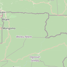
Map view of Minkébé National Park

Use this park location map to pinpoint Minkébé National Park in Gabon, understand its exact geographic position, and read its mapped placement within the surrounding landscape more clearly.

Pigeon | © OpenStreetMap contributors

Location context for Minkébé National Park

Woleu-Ntem Province
Park atlas

Trace connected forest complexes and conservation landscapes within the broader Central African region

Discover Other National Parks and Protected Areas Near Minkébé National Park in Central Africa
Browse national parks and protected areas situated near Minkébé National Park, revealing diverse lowland forest ecosystems and unique inselberg terrain. Compare their geographic spread, conservation landscapes, and shared wildlife populations within the broader Central African region, enriching your atlas discovery.
National parkGabon

Ivindo National Park: A Protected Rainforest Landscape in Gabon

Explore its waterfalls, diverse ecosystems, and mapped geographic context.

Ivindo National Park represents a significant protected landscape within Gabon, spanning a vast area of intact tropical rainforest. Recognized as a UNESCO World Heritage Site, the park is defined by the Ivindo River and its dramatic waterfalls, including the famous Kongou and Mingouli Falls. Its geography includes mountainous terrain and vital riverine ecosystems, supporting critical populations of forest elephants and great apes. This page offers a gateway to understanding the park's protected status, its unique natural features, and its role in the broader geography of Central Africa.

Area
3,000 km²
Established
2002
IUCN
II
Relief
Mixed relief
National parkEquatorial Guinea

Altos de Nsork National Park: Equatorial Guinea's Protected Landscape and Map Context

Explore the mapped boundaries of this national park.

Altos de Nsork National Park stands as a designated national park within Equatorial Guinea, offering a distinct protected landscape. This entry provides essential atlas-driven details, emphasizing its geographic setting and mapped park boundaries. Understand its regional context and its significance as part of the conservation network in Central Africa, contributing to a richer understanding of mapped natural terrains.

Area
700 km²
Established
2000
IUCN
II
Relief
Highland
National parkCameroon

Nki National Park: Protected National Park Landscape in Cameroon

Explore the geographic context and mapped boundaries.

Nki National Park is a designated national park in Cameroon, offering a distinct protected landscape for geographic study. This page provides essential context for understanding the park's place within the country's natural geography and protected areas atlas. Explore its mapped terrain and protected boundary details to gain a clearer picture of this natural entity within Central Africa's diverse geography.

Area
3,093 km²
Established
2005
IUCN
II
Relief
Upland
National parkCuvette-Ouest Department

Odzala-Kokoua National Park National Park: Mapped Protected Landscape in Cuvette-Ouest

Explore its geographic boundaries and regional terrain.

Odzala-Kokoua National Park is a key national park entity, offering a distinct protected landscape within the Cuvette-Ouest Department. This page provides an atlas-style exploration of its mapped boundaries and geographic context. Delve into the specifics of this protected area to understand its contribution to the regional geography and natural landscape, facilitating structured discovery of its terrain.

Area
13,500 km²
Established
1935
IUCN
II
Visitors
50 annual
Watercolor painting of a landscape with grassy areas, a lake, and distant hills under a light sky
National parkGabon

Lopé National Park: Gabon's Protected Landscape and National Park Geography

Explore mapped boundaries and natural terrain in Central Africa.

Delve into Lopé National Park, a designated national park situated in Gabon. This protected area serves as a crucial point for understanding the nation's geography and the distribution of its conservation landscapes. As an entry in the MoriAtlas, it offers a detailed view of its mapped territory and its contribution to the broader regional context of Central Africa, emphasizing its role in protected area atlas exploration.

Area
4,910 km²
Established
2002
IUCN
II
Relief
Mixed relief
National parkEquatorial Guinea

Monte Alén National Park National Park: Mapped Protected Landscape in Equatorial Guinea

Explore regional geography and park boundaries.

Monte Alén National Park, a designated national park in Equatorial Guinea, offers a unique focal point for understanding protected landscapes. This entry provides detailed geographic context, highlighting the park's mapped boundaries and its significance within the atlas of Central African natural terrain. Investigate the terrain and regional setting of Monte Alén National Park for structured geographic discovery.

Area
2,000 km²
Established
1990
IUCN
II
Relief
Mountain
National parkWoleu-Ntem Province

Crystal Mountains National Park: National Park Protected Area and Geographic Context in Woleu-Ntem Province

Explore its mapped boundaries and regional landscape.

Crystal Mountains National Park is a designated national park offering critical insights into its protected landscape and geographic setting. Users can explore the mapped boundaries of this protected area, understand its regional terrain, and gain context within Woleu-Ntem Province through structured geographic data. This page provides the foundational atlas information for comprehending the park's conservation significance and natural features.

Area
1,200 km²
Established
2002
IUCN
II
Relief
Mountain
National parkCameroon

Campo Ma'an National Park: Essential Protected Landscape in Cameroon's Atlantic Biafran Forest

Mapped evergreen canopy and vital great ape habitat in a key conservation area.

Campo Ma'an National Park is a crucial protected area in Cameroon, spanning 2,680 square kilometers of dense Atlantic Biafran forest. Established for environmental compensation, it safeguards critical habitat for western lowland gorillas and central chimpanzees, alongside forest elephants and diverse birdlife. The park's landscape is defined by a persistent evergreen canopy ecosystem, offering a unique context for understanding Central African rainforest geography and protected land status.

Area
2,680 km²
Established
2000
IUCN
II
Climate
Tropical

Common questions about visiting, size, designation, and location context for Minkébé National Park

Minkébé National Park FAQs for park facts, access, geography, and protected area context
Find quick answers about Minkébé National Park, including protected-area facts, park geography, trail and visitor context, and how the park fits into its surrounding country and regional landscape.
MoriAtlas Explorer

Continue Your Protected Areas Search Across the Global Atlas

Deepen your exploration by continuing the structured search for national parks and protected areas worldwide. Utilize the comprehensive filtering capabilities to compare different conservation landscapes and refine your understanding of global park geography. Discover more about the distribution and characteristics of protected natural areas.

Global natural geography