Mori Atlas logo
National parkFaro National Park

Discover the geography, mapped boundaries, and significant megafauna of this key protected area.

Faro National Park: A National Park Mapping Vast Sudano-Sahelian Protected Landscapes in Cameroon

Faro National Park represents a crucial protected landscape within Cameroon's North Region, spanning approximately 3,300 square kilometers of the Faro River basin. This national park is distinguished by its extensive Sudano-Sahelian savanna terrain, characterized by undulating plains, river valleys, and scattered hilltops, creating a varied natural environment. As a protected area, it is internationally recognized for harboring the largest hippopotamus population in Central and West Africa, alongside other significant large mammals. Exploring Faro National Park offers a deep dive into regional geography and the mapped context of vital conservation efforts.

National ParkProtected AreaSudano-Sahelian EcosystemLarge MammalsHippo PopulationTransboundary Conservation

Faro National Park

National park

Park overview

Structured park overview, official facts, and landscape profile for Faro National Park

Faro National Park park facts, protected area profile, and essential visitor context
Review the core facts for Faro National Park, including designation, size, terrain, visitor scale, habitats, and operating context in one park-focused overview.

About Faro National Park

Faro National Park represents one of Cameroon’s principal protected areas in the northern ecological zone, spanning approximately 3,300 square kilometres of the Faro River basin in the North Region. The park lies in proximity to the Nigerian border and forms part of a contiguous protected landscape that extends across the frontier into Gashaka Gumti National Park, creating a transboundary conservation area of regional significance. The park’s setting within the Sudano-Sahelian region distinguishes it from Cameroon’s more humid southern ecosystems, characterised by seasonal rainfall patterns and a transition between woodland and grassland habitats. The Faro and Déo rivers traverse the protected area, providing critical water resources for wildlife and creating varied microhabitats throughout the park. These rivers exhibit pronounced seasonal fluctuations, with water levels dropping during drier periods to reveal sandy embankments along their banks. The park’s topography features generally undulating terrain with river valleys cutting through savanna plains and occasional hilltops rising above the surrounding landscape. This combination of hydrological features and varied topography supports the diverse ecological communities that give Faro its character as a refuge for large mammals and unique vegetation types.

Quick facts and research context for Faro National Park

Faro National Park is located in northern Cameroon near the Nigerian border, protecting a Sudano-Sahelian ecosystem in the Faro River basin. The park covers roughly 3,400 square kilometres of savanna, woodland, and river valley landscapes at elevations between 250 and 700 metres. It was established in 1989 and forms part of a transfrontier protected area network with neighbouring Gashaka Gumti in Nigeria. The park supports significant populations of elephants, lions, cheetahs, black rhinoceros, and hippopotamus.

Park context

Deeper park guide and search-rich context for Faro National Park

Faro National Park history, landscape, wildlife, and travel context
Explore Faro National Park through its history, landscape character, ecosystems, wildlife, conservation priorities, cultural context, and seasonal travel timing in a structured park guide built for atlas discovery and search intent.

Why Faro National Park stands out

Faro National Park is best known for protecting the largest hippopotamus population in Central and West Africa, a distinction that makes it particularly significant within the regional protected area network. The park also stands out for its diverse large mammal assemblage, which includes African elephants, lions, cheetahs, and black rhinoceros, all of which face conservation challenges across their ranges. The combination of Sudano-Sahelian savanna ecosystems with interspersed forest habitats creates a mosaic landscape that supports this remarkable biodiversity.

Satellite image showing the confluence of two rivers in Faro National Park, Cameroon, with surrounding green landscape
Satellite view of the confluence of the Mao Deo and Faro rivers within Faro National Park

Faro National Park history and protected-area timeline

Faro National Park was officially incorporated into Cameroon’s protected area system in 1980 by government decree, with formal establishment as a national park following in 1989. The park was created as part of Cameroon’s commitment to conserving its natural heritage and fulfilling obligations under regional and international conservation frameworks. From its inception, the park was designed to function within a broader Central African protected landscape that transcended national boundaries, linking with Nigeria’s Gashaka Gumti National Park to form a transfrontier conservation area. This strategic alignment reflected growing recognition that effective wildlife conservation required coordinated approaches across jurisdictions, particularly for migratory species and ecosystems that naturally span borders. The governance of the park falls under Cameroon National Parks, the national body responsible for managing the country’s protected area network.

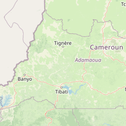
Faro National Park landscape and geographic character

The landscape of Faro National Park is defined by its position within the Sudano-Sahelian transitional zone, where the characteristics of the Sahel meet the more lush Sudanian ecosystems to the south. The terrain consists predominantly of savanna plains with an undulating character, broken by river valleys that carry the Faro and Déo rivers through the protected area. Scattered hilltops rise above the general plain elevation, adding topographic variation to the landscape while the river valleys provide lower-lying corridors with distinct vegetation. The park’s elevation ranges from approximately 250 metres in the valley bottoms to around 700 metres on higher ground, creating a relatively modest but meaningful range of microclimatic conditions. The river systems are seasonally variable, with water levels fluctuating significantly between wet and dry seasons. During the dry season, the rivers recede to expose sandy embankments along their margins, changing the visual character of the landscape and altering available habitat for riverine species. The combination of open savanna, woodland patches, river corridors, and elevated ground creates a heterogeneous landscape that supports diverse ecological communities.

Faro National Park ecosystems, habitats, and plant life

The vegetation of Faro National Park reflects the park’s position within the Sudano-Sahelian transition zone, featuring a mosaic of habitats that varies from south to north. The southern portions of the park support Sudanian savanna woodlands, where taller trees provide canopy cover amid seasonal grasses. Moving northward, the character shifts toward mixed grasslands with more open savanna conditions. Throughout the park, dense deciduous and semi-evergreen forests occur as interspersed patches, particularly in areas with more favourable moisture conditions such as river valleys and lower slopes. This forest vegetation provides critical habitat for species that require more cover than the open savanna offers. The presence of multiple habitat types within a relatively compact area creates ecological diversity that supports a wide range of species. The park’s own microclimate, influenced by the combination of savanna and forest habitats, contributes to the biological richness that distinguishes Faro from more uniform surrounding landscapes.

Faro National Park wildlife and species highlights

Faro National Park is distinguished by its substantial populations of large mammals, making it one of Cameroon’s most significant protected areas for megafauna. The park supports colonies of hippopotamus that represent the largest population of this species in both Central and West Africa, a remarkable concentration that ranks among the park’s most notable ecological features. African elephants traverse the savanna and woodland habitats, while African lions persist as apex predators within the ecosystem. Cheetahs occur in the more open grassland areas, where their speed provides advantage in hunting prey species. Black rhinoceros, though facing severe pressure throughout their range, continue to occupy suitable habitat within the park’s boundaries. These species collectively represent a significant assembly of large mammals that depends on the protected status that Faro provides. The combination of savanna, woodland, and forest habitats creates conditions that support this diverse megafauna community, with different species occupying different habitat niches throughout the park.

Faro National Park conservation status and protection priorities

Faro National Park faces multiple conservation challenges that require ongoing attention and resources. Commercial poaching represents a significant threat to large mammal populations, particularly elephants for ivory and rhinos for their horns, both of which face intense illegal demand. Climate change introduces additional uncertainty, potentially altering the seasonal patterns that wildlife and local communities depend upon. Illegal fishing in the park’s rivers affects aquatic ecosystems and species such as hippopotamus that rely on riverine environments. Mining activities in the surrounding region can create pressure on park boundaries and contribute to habitat degradation. Human-wildlife conflict arises from cross-border livestock rearing, as herders from Nigeria and Cameroon move animals through the region, sometimes entering the park and creating tensions with wildlife. Conservation organisations work collaboratively with the Cameroon government to address these challenges while ensuring that the needs of local communities and Indigenous peoples are incorporated into management approaches.

Top sights and standout views in Faro National Park

Faro National Park protects Central and West Africa’s largest hippopotamus population within a Sudano-Sahelian landscape of savanna, woodland, and river valleys. The park forms part of a transboundary conservation network with Nigeria’s Gashaka Gumti National Park, creating a protected landscape that spans the international border. Large mammals including elephants, lions, cheetahs, and black rhinoceros occupy the park’s varied habitats, making it one of Cameroon’s most significant areas for megafauna conservation.

Best time to visit Faro National Park

The best time to visit Faro National Park falls during the dry season from November to April, when wildlife congregates more visibly around remaining water sources and vegetation is less dense, improving visibility for observation. The landscape character changes noticeably between seasons, with the dry season revealing sandy river embankments as water levels recede while the wet season brings green vegetation and increased water flow through the river systems. Visitors interested in wildlife viewing should consider how seasonal conditions affect both animal distribution and the practicalities of park exploration.

Park location guide

Geography guide, regional context, and park location map for Faro National Park

Faro National Park park geography, regions, and map view in Cameroon
Understand where Faro National Park sits in Cameroon through a broader geographic reading of the surrounding landscape, nearby location context, and its mapped position within the national park landscape.

How Faro National Park fits into Cameroon

Cameroon is a Central African country spanning coastal, highland, and forest regions. It has a population of nearly 31 million people who speak 250 native languages alongside English and French as official languages. The country gained independence from France in 1960 and unified with British Southern Cameroons in 1961.

Wider geography shaping Faro National Park in Cameroon

Cameroon is located in Central Africa, bordering Nigeria and Chad to the west and north, the Central African Republic to the east, and Equatorial Guinea, Gabon, and the Republic of the Congo to the south. The country has a coastline on the Bight of Biafra, part of the Gulf of Guinea. Terrain includes coastal plains, mountainous highlands (including Mount Cameroon), plateaus, and dense rainforest regions.

Map view of Faro National Park

Use this park location map to pinpoint Faro National Park in Cameroon, understand its exact geographic position, and read its mapped placement within the surrounding landscape more clearly.

Pigeon | © OpenStreetMap contributors

Explore diverse savanna scenery, riverine ecosystems, and the protected environment of Central Africa's significant park.

Faro National Park Photos: Visualizing Cameroon's Sudano-Sahelian Landscapes and Wildlife Habitats
Visually explore the unique Sudano-Sahelian landscapes of Faro National Park, showcasing its undulating savanna plains, critical river valleys, and varied terrain in Cameroon. Immerse yourself in the park's environment through comprehensive imagery, gaining insight into its large mammal habitats, including the vast hippopotamus populations, and understanding the distinct character of this vital protected area.

Satellite image showing the confluence of two rivers in Faro National Park, Cameroon, with surrounding green landscape

Park atlas

Explore the regional park geography and discover other protected landscapes bordering Faro National Park in Central Africa

Discover Other National Parks and Protected Areas Near Faro National Park in Cameroon
Browse a curated list of national parks and protected areas geographically close to Faro National Park, spanning Cameroon and the broader Sudano-Sahelian transition zone. Compare diverse protected landscapes, trace their geographic spread, and enrich your understanding of Central Africa's park networks and transboundary conservation efforts.
Watercolor illustration of a landscape with rolling hills, a winding river, and varied terrain in soft colors
National parkBénoué Department

Bénoué National Park: Protected Landscape Atlas in Bénoué Department, Cameroon

Explore savanna woodland, riparian ecosystems, and geographic context.

Bénoué National Park is a vast protected landscape in Cameroon, defined by its Sudanian savanna woodland and significant frontage along the Bénoué River. Recognized as a UNESCO Biosphere Reserve, it offers critical insights into regional geography, habitat diversity, and the broader atlas of conservation lands in West Africa. Users can explore its varied terrain, from riverine zones to higher massifs, gaining a detailed understanding of this important protected area.

Area
1,800 km²
Established
1968
IUCN
II
Relief
Mixed relief
National parkCameroon

Bouba Njida National Park: A Protected Landscape within Cameroon's National Park Atlas

Discover its mapped geography and regional context.

Bouba Njida National Park represents a key component of Cameroon's protected lands, contributing essential context to any atlas of Central African geography. As a designated national park, it offers a distinct focus for understanding mapped landscape features and the distribution of protected areas within the country. This park serves as a vital point of reference for exploring the nation's natural terrain and its significance within the broader context of regional conservation efforts.

Area
2,200 km²
Established
1980
IUCN
II
Relief
Upland
National park

Deng Deng National Park: Protected Landscape & Gorilla Habitat in East Cameroon

Discover the mapped geography and conservation significance of this national park.

Deng Deng National Park in Cameroon's East Region offers a unique glimpse into the Northern Congolian forest-savanna mosaic ecoregion. Spanning about 683 square kilometers and shaped by the Sanaga River, it is critically important as the northernmost known habitat for western lowland gorillas. Its diverse terrain supports not only gorillas but also elephants, chimpanzees, and pangolins, highlighting its role in Central African biodiversity and regional landscape context.

Area
682.64 km²
Established
2010
IUCN
II
Climate
Tropical
National parkCentre Region

Mpem and Djim National Park: Protected Landscape and Regional Geographic Atlas

Explore the mapped terrain and protected boundaries of this national park.

Mpem and Djim National Park is a protected natural area situated within Cameroon's Centre Region. This detail entry provides an atlas-focused view, emphasizing the park's protected landscape characteristics and its position within the regional geography. Understand the mapped context and discover the identity of Mpem and Djim National Park as a key protected area.

Area
974.8 km²
Established
2004
IUCN
II
Relief
Upland
National parkFar North Region

Waza National Park: A Designated Protected Landscape in the Far North Region

Mapped Boundaries and Regional Geographic Context

Waza National Park stands as a vital protected natural landscape in Cameroon's Far North Region. This entry provides a deep dive into its mapped protected-area boundaries and its significance within the broader regional geography. Explore the specific landscape identity of this national park through an atlas-focused lens, understanding its terrain and context without travel logistics or visitor advice.

Area
1,700 km²
Established
1934
IUCN
II
Relief
Lowland
National parkNigeria

Chad Basin National Park: Exploring Nigeria's Protected Natural Landscape

Mapped protected area and regional geography context.

Chad Basin National Park is a key protected landscape within Nigeria, designated as a national park. This page serves as a gateway to understanding its specific geographic identity, mapped boundaries, and its role within the country's natural terrain. Users can explore detailed information, focusing on the park's atlas-relevant features and its contribution to Nigeria's protected areas, offering a distinct view of the nation's geography.

Area
2,258 km²
Established
1991
IUCN
II
Relief
Lowland
National parkCameroon

Bakossi National Park: Detailed Protected Area Map and Geographic Identity in Cameroon

Explore the mapped landscape and regional context of this Cameroonian national park.

Bakossi National Park is an important protected area situated within Cameroon, functioning as a national park dedicated to conservation and geographic study. This page provides essential details on its mapped boundaries, regional setting, and the natural landscape it represents. It serves as a foundational element for understanding protected areas in Central Africa and their broader geographical significance.

Area
293.2 km²
Established
2008
Relief
Mountain
Climate
Tropical
Watercolor illustration of a forested landscape with pink flowering plants, a winding river, and mountain ranges in the background
National park

Korup National Park: Cameroon's Ancient Tropical Rainforest Protected Area Exploration

Explore its rich biodiversity and unique geographic landscape.

Korup National Park is a significant protected area in Cameroon, covering 1,260 square kilometers of what is considered one of Africa's oldest and most biodiverse tropical rainforests. Established in 1986, this national park is renowned for its exceptional primate populations, extensive plant species, and its role as a critical conservation landscape. The park's terrain transitions from lowlands to hilly areas, with a dense network of streams, offering a rich subject for geographic and protected-area study.

Area
1,260 km²
Established
1986
IUCN
II
Relief
Mixed relief

Common questions about visiting, size, designation, and location context for Faro National Park

Faro National Park FAQs for park facts, access, geography, and protected area context
Find quick answers about Faro National Park, including protected-area facts, park geography, trail and visitor context, and how the park fits into its surrounding country and regional landscape.
MoriAtlas Explorer

Continue Your Protected Areas Search Across the Global Atlas

Deepen your exploration by continuing the structured search for national parks and protected areas worldwide. Utilize the comprehensive filtering capabilities to compare different conservation landscapes and refine your understanding of global park geography. Discover more about the distribution and characteristics of protected natural areas.

Global natural geography