Mori Atlas logo
State or regional parkBeijing Xishan National Forest Park

Examining the forested ridgelines and cultural heritage sites within this urban-fringe protected area

Beijing Xishan National Forest Park: A Protected Landscape in the Western Hills of Beijing

Beijing Xishan National Forest Park stands as a significant protected forest, marking the transition between the urban sprawl of Beijing and the rugged foothills of the Taihang Mountains. This park preserves a mosaic of planted coniferous and broadleaf woodlands, set across rocky ridges and narrow valleys that characterize the Xiao Xishan range. Beyond its ecological function, the landscape incorporates layers of imperial history and modern memorials, creating a distinctive blend of natural terrain and cultural heritage near the city center.

national forest parkurban forestperi-urban parkplanted forestmixed woodlandconiferous and broadleaf forest

Beijing Xishan National Forest Park

State or regional park

Park overview

Structured park overview, official facts, and landscape profile for Beijing Xishan National Forest Park

Beijing Xishan National Forest Park park facts, protected area profile, and essential visitor context

Review the core facts for Beijing Xishan National Forest Park, including designation, size, terrain, visitor scale, habitats, and operating context in one park-focused overview.

About Beijing Xishan National Forest Park

Beijing Xishan National Forest Park occupies a strategic position on the western fringe of China's capital, providing a forested buffer between the dense urban core and the more rugged terrain of the Taihang Mountains' eastern edge. The park's foundation is the Xiao Xishan range, a low mountain system of rocky slopes where shady aspects tend to be steep while sunny slopes are gentler. The park's highest accessible point, known as Guixiao Shi or the "Laughing Stone," rises to about 473 meters and has become a popular nighttime viewpoint overlooking illuminated Beijing.

Functionally, the park is both an ecological asset and a recreational anchor for the capital region. Its forests are overwhelmingly the product of post-1949 afforestation, transforming previously barren hills into a varied mixed woodland. Visitors encounter themed gardens featuring peonies, crape myrtles, magnolias, and plums, as well as broader forest tracts used for hiking, climbing, and educational programs. The park has been designated a national-level study practice base for primary and secondary school students, and it regularly hosts organized events, including large forest culture festivals.

Culturally, the Western Hills context elevates the park beyond a typical urban forest. For centuries, rulers of dynasties based in Beijing constructed retreats, temples, and burial grounds in these hills, leaving a dense constellation of heritage sites. Within the broader park area, visitors can reach important temples, imperial tombs, and commemorative monuments. The integration of living forest, mountain scenery, and centuries of human history gives the park a uniquely metropolitan character among China's national forest parks.

Quick facts and research context for Beijing Xishan National Forest Park

Beijing Xishan National Forest Park is a national forest park administered under China's National Forestry and Grassland Administration, located in the Xiao Xishan range on the western outskirts of Beijing. It was officially established in 1992 and grew out of the Beijing Xishan Experimental Forest Farm, which itself traces back to early 1950s afforestation campaigns. The park's terrain is low-mountain, rocky, and part of the eastern tail of the Taihang Mountains. It is recognized for its role as an accessible green recreation area for metropolitan Beijing and for the integration of scenic and cultural sites within a managed forest setting.

Protection and recognition

Documented terrestrial protection history and management scope details

Beijing Xishan National Forest Park Protection Status and Designation

Beijing Xishan National Forest Park maintains a documented terrestrial protection status established in 1992. This record outlines the official designation history and management framework associated with the protected landscape.

Protection details

Protection scope
Terrestrial
Designated year
1992
Transboundary protection
No
Park context

Deeper park guide and search-rich context for Beijing Xishan National Forest Park

Beijing Xishan National Forest Park history, landscape, wildlife, and travel context

Explore Beijing Xishan National Forest Park through its history, landscape character, ecosystems, wildlife, conservation priorities, cultural context, and seasonal travel timing in a structured park guide built for atlas discovery and search intent.

Why Beijing Xishan National Forest Park stands out

The park is best known for being the closest nationally designated forest park to central Beijing, offering easy access to wooded ridgelines, panoramic city viewpoints, and themed seasonal scenery. Its forest mosaic of conifers and broadleaf species produces vivid spring blossoms, lush summer greens, dramatic autumn color across roughly 5,000 mu of colorful-leaf forest, and stark winter landscapes. It is also recognized for its layered cultural landscape. The surrounding Western Hills hold imperial-era sites, Ming-dynasty tombs, Qing-period banner village remnants, and modern memorials, including the Unnamed Heroes Memorial Square dedicated to covert operatives of the early 1950s. The combination of planted forest scenery and embedded historical sites gives the park a distinctive identity among Beijing's protected natural areas.

A large, ornate, traditional Chinese-style gate with golden roofs and intricate blue and red patterns against a clear blue sky, serving as the entrance to the park.
The traditional ornamental gate (pailou) at the entrance of Beijing Xishan National Forest Park.

Beijing Xishan National Forest Park history and protected-area timeline

The Western Hills of Beijing have been associated with imperial retreat scenery for many centuries. In the early eleventh century, the Liao dynasty built a detached palace in the Xishan area, and by the late twelfth century the Jinshan Zhangzong dynasty was developing Xiangshan as a refined leisure landscape. Successive dynasties ruling from Beijing continued to build villas and gardens in these hills, considering the area a prized "feng shui" location favored by emperors, nobles, and literati.

Modern history of the site begins with organized afforestation. Tree planting in the Western Hills started in 1913, yet by 1949 the forested area covered only about 4,200 mu, with a tree cover rate of just 4.7 percent. In the early 1950s, the hills were largely bare. The Beijing municipal government launched large-scale greening campaigns beginning in 1952, creating a dedicated Xishan afforestation office and mobilizing mass participation. In 1953, Marshal Zhu De inspected the area and called on North China forestry authorities to prioritize its greening.

Between 1955 and 1957, tens of thousands of mu were planted. In 1962 and 1963, the afforestation office was reorganized into the Beijing Xishan Experimental Forest Farm, shifting work from voluntary planting toward professional forestry. During the 1960s, the farm also absorbed hundreds of young graduates as forestry workers and expanded planting, tending, and fruit-tree cultivation. In 1984, planning began for a forest park on this base, and in September 1992 the Ministry of Forestry formally approved the establishment of Beijing Xishan National Forest Park, marking the transition from a working forest farm to a nationally recognized forest park.

Beijing Xishan National Forest Park landscape and geographic character

The park lies in the Xiao Xishan range, which forms part of the easternmost extensions of the Taihang Mountains as they descend toward the North China Plain. The terrain is characterized as low mountain country with a rocky, stony substrate. Slopes on the shaded sides are typically steeper, while sunny slopes tend to be more gradual, creating varied exposure that supports different microhabitats within the forest.

Rocky ridgelines, narrow valleys, and broad gentle footslopes give the park a diverse topography despite its modest elevations. The highest point, Guixiao Shi at about 473 meters above sea level, is a rocky prominence on the ridge that has become a celebrated viewing platform. From the ridge, the landscape transitions sharply from forested slopes to the densely built expanse of metropolitan Beijing, producing a striking visual contrast between wooded hill country and capital-city skyline.

Beijing Xishan National Forest Park ecosystems, habitats, and plant life

Ecologically, the park sits within Beijing's warm-temperate continental monsoon climate zone, featuring four distinct seasons, short spring and autumn, and prolonged summer and winter. Mean annual temperatures lie in the range of 10 to 13 degrees Celsius, with cold winters and hot, rainy summers. Vegetation reflects the regional zonal pattern of warm-temperate deciduous broadleaf forest, but unlike remote wild forests, the Xishan woodlands are predominantly artificial, established through decades of deliberate planting.

The mixed forests of Chinese pine, oriental arborvitae, black locust, and smoke tree, along with a wide range of associated shrubs and ornamental species, create varied stand structures across the hills. Roughly 5,000 mu of the park are managed as colorful-leaf forest, producing vivid red, yellow, and amber displays in autumn. Beyond the woodland matrix, special plant gardens showcase peonies, crape myrtles, magnolias, and plums, adding horticultural diversity to the broader ecological setting.

Beijing Xishan National Forest Park wildlife and species highlights

The park's wildlife profile reflects its character as a planted suburban forest embedded in a metropolitan region. Recorded fauna include around ten species of mammals, more than fifty species of birds, and several amphibian and reptile species. Although the park is not a remote wilderness reserve, its forest cover, varied topography, and proximity to less-developed ridgelines provide habitat for typical North China warm-temperate forest fauna.

The combination of mixed woodland, shrub layers, and seasonal food resources supports both resident and seasonally visiting birdlife. Smaller mammals typical of Beijing's forested hills find refuge in the denser stands, while the park's role as a major green space within the urban region increases its importance as an everyday wildlife refuge for the capital.

Beijing Xishan National Forest Park conservation status and protection priorities

Conservation significance at Xishan National Forest Park centers on the transformation and long-term stewardship of a heavily impacted peri-urban landscape. Beginning in the early 1950s, what had been largely denuded hills were systematically reforested, and the subsequent decades of professional management by Xishan Experimental Forest Farm built a durable forested cover that continues to anchor the park's ecological function today.

The park also serves as a testbed for applied conservation technology, particularly in wildfire prevention. Beginning in 2007, managers pioneered the development of so-called "plant firewalls" within the woodland, and by 2022 these tree- and shrub-based firebreaks had been expanded into nineteen lines totaling about 27 kilometers. As a national study practice base and a major public forest park, Xishan also plays an important environmental education role for the capital region.

Beijing Xishan National Forest Park cultural meaning and human context

The Western Hills of Beijing carry a layered cultural identity stretching back nearly a millennium. From Liao and Jin imperial retreats through Ming and Qing gardens, the hills were repeatedly chosen as a setting for palaces, temples, and burial grounds. The nearby landscape clusters include historically celebrated groupings such as the "Three Hills and Five Gardens" and the "Eight Western Hills Courtyards," several of which are linked to Qing banner military communities whose village names still survive in the area.

Within and around the park are numerous heritage sites, including Ming imperial tombs such as the Jingtai Emperor's mausoleum, Qing-era remains, and several important Buddhist temples. A long-established pilgrimage road winds through the hills. The park also preserves more recent memorial landscapes, including the Unnamed Heroes Memorial Square, dedicated to covert operatives lost in the early 1950s, and the nearby Baiwangshan area, which commemorates a 1937 anti-Japanese engagement. The graves of several twentieth-century cultural and military figures are scattered through the hills, reinforcing the area's role as a continuous cultural landscape layered onto the natural forest setting.

Top sights and standout views in Beijing Xishan National Forest Park

Among the park's strongest attractions are its panoramic ridge viewpoints, particularly the famous Guixiao Shi lookout, and its seasonal color displays, especially across the extensive colorful-leaf forest in autumn. Themed gardens featuring peonies, crape myrtles, magnolias, and plums give visitors concentrated floral showcases within a broader forest setting.

A second distinguishing layer is the integration of cultural and memorial sites, including the Unnamed Heroes Memorial Square, historical tombs, temple ruins, pilgrim pathways, and the nearby Baiwangshan area with its anti-Japanese war monument. The park's accessibility from central Beijing combined with this combination of forest scenery and heritage density makes Xishan a uniquely metropolitan national forest park experience.

Best time to visit Beijing Xishan National Forest Park

Autumn is widely considered the standout season at Xishan National Forest Park, when the park's roughly 5,000 mu of colorful-leaf forest turn red, yellow, and amber against the dark conifers. Cool, dry conditions typical of Beijing's short autumn also make hiking the ridges and reaching viewpoints like Guixiao Shi especially pleasant.

Spring offers fresh green growth and the bloom cycles of the peony, magnolia, crape myrtle, and plum gardens, while summer brings the densest foliage and shade, paired with warm temperatures and higher humidity. Winter visits are also feasible and reward visitors with stark ridge scenery, fewer crowds, and clear views over the city, though conditions are cold and dry.

Monthly climate preview

Long term temperature and precipitation records measured at a representative coordinate

Beijing Xishan National Forest Park Climate Normals and Monthly Weather Patterns

Historical climate data for Beijing Xishan National Forest Park shows a wide annual temperature range alongside distinct monthly variations in precipitation. Examining the complete twelve month profile provides deeper insight into measured long term weather norms across the protected landscape.
Annual mean11 °C
-5 °C26 °C
Jan-5°
Feb-2°
Mar
Apr13°
May20°
Jun25°
Jul26°
Aug25°
Sep20°
Oct12°
Nov
Dec-4°
Warmest month
July

26.5 °C

Coolest month
January

-5.3 °C

Wettest month
July

5.3 mm/day

Driest month
January

0.1 mm/day

Park location guide

Geography guide, regional context, and park location map for Beijing Xishan National Forest Park

Beijing Xishan National Forest Park park geography, regions, and map view in China

Understand where Beijing Xishan National Forest Park sits in China through a broader geographic reading of the surrounding landscape, nearby location context, and its mapped position within the national park landscape.

How Beijing Xishan National Forest Park fits into China

China is a unitary communist state in East Asia, governed by the Chinese Communist Party. The country's capital is Beijing, while Shanghai is the largest city by urban population. China has 33 province-level divisions including provinces, autonomous regions, municipalities, and special administrative regions. The nation has a long history spanning thousands of years, with achievements including the invention of gunpowder, paper, printing, and the compass.

Wider geography shaping Beijing Xishan National Forest Park in China

China is located in East Asia, bordering fourteen countries: Russia, North Korea, Vietnam, Laos, Myanmar, India, Bhutan, Nepal, Pakistan, Afghanistan, Tajikistan, Kyrgyzstan, Kazakhstan, and Mongolia. The country spans diverse terrain including deserts, mountains, plateaus, and river valleys. Major river systems include the Yellow River and Yangtze River. The coastline stretches along the East China Sea, South China Sea, and Yellow Sea.

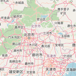
Map view of Beijing Xishan National Forest Park

Use this park location map to pinpoint Beijing Xishan National Forest Park in China, understand its exact geographic position, and read its mapped placement within the surrounding landscape more clearly.

Pigeon | © OpenStreetMap contributors

Location context for Beijing Xishan National Forest Park

Beijing

Visual reference guide to forest habitats, mountain terrain, and seasonal colors

Beijing Xishan National Forest Park Photos and Landscape Scenery

Visual documentation captures the wooded ridgelines, rocky terrain, and seasonal color transitions defining Beijing Xishan National Forest Park. Detailed national park photography reveals the unique topography and protected habitats spanning the Western Hills foothills.

A large, ornate, traditional Chinese-style gate with golden roofs and intricate blue and red patterns against a clear blue sky, serving as the entrance to the park.

Park atlas

Compare surrounding regional geography and connected protected landscapes

Explore Other Parks Near Beijing Xishan National Forest Park

Discover nearby national forest parks and protected areas sharing the rugged terrain of the Western Hills. Expanding the geographic comparison reveals broader ecological patterns across the metropolitan green space.
A watercolor illustration of rolling hills with scattered trees under a soft, light-filled sky.
Protected landscapeDalian
About 520 km away#1 closest

East

Jinshitan National Resort: Exploring the Coastal Geopark and Protected Landscapes of Dalian

Ancient sedimentary rock formations and coastal terrain mapping

Investigate the complex geography of Jinshitan National Resort, a prominent coastal area in Dalian, China. This protected landscape combines natural heritage, including unique stone forest formations shaped by millions of years of erosion, with long, sloping golden beaches that define the regional coastline along the Yellow Sea.

Area
120 km²
Established
1984
Relief
Lowland
Climate
Temperate
Protected areaSükhbaatar Province
About 601 km away#2 closest

North

Ganga Lake Protected Area: Geographic Boundaries and Wetland Ecosystems in Sükhbaatar Province

A unique saline steppe-to-desert transition zone

Ganga Lake represents a critical wetland corridor in eastern Mongolia, where saline water bodies meet vast grasslands and sand dunes. This protected area acts as a focal point for migratory birds, offering a distinct study in regional geography and terrain contrast between the arid Gobi edge and the open Mongolian steppe.

Area
2.2 km²
Established
2004
Relief
Lowland
Scope
Terrestrial
Protected landscapeHenan
About 611 km away#3 closest

Southwest

郑州黄河风景名胜区: Geographic Profile of a Henan Protected Landscape

Mapping the confluence of the Yellow River and Mang Mountain

The 郑州黄河风景名胜区 is a prominent protected landscape in Henan that highlights the dynamic geography of the Yellow River basin. Characterized by the transition between loess highlands and river floodplains, this area offers an essential study of how terrain and water define regional boundaries. Users can examine the specific topographical features, including Wulong Peak and the river-facing ridges, that distinguish this site within the broader Central China atlas.

Area
20 km²
Established
1981
Relief
Upland
Climate
Temperate
A watercolor painting showing a winding river flowing through a soft green landscape with grassy banks under a white sky.
National parkDornod Province
About 808 km away#4 closest

North

Numrug National Park: Mapping the Transitional Geography of Eastern Mongolia

Protected river valleys and forest foothills in Dornod Province

Spanning the easternmost edge of Mongolia, Numrug National Park showcases a layered landscape where mountainous woodland merges with open grassland. The park's hydrological character, defined by the Degee and Khalkh rivers, creates a complex network of riparian habitat that serves as a vital ecological boundary within the broader Dornod Province terrain.

Established
1992
Relief
Mountain
Water
Major water bodies
Nature reserveDornogovi Province
About 863 km away#5 closest

Northwest

Ikh Nartiin Chuluu Nature Reserve: Mapping Granite Outcrops and Steppe in Dornogovi Province

A vital protected sanctuary within the Mongolian Gobi desert landscape

Ikh Nartiin Chuluu Nature Reserve occupies a unique position in the Dornogovi Province of Mongolia, where granite skeletons meet arid plains. The protected area serves as a significant biological stronghold, offering a detailed study of how rocky crevices and sheltered valleys support diverse steppe life. Use this atlas resource to understand the park boundaries, terrain features, and regional landscape context that make this reserve a reference site for desert conservation.

Area
660 km²
Established
1996
Relief
Upland
Climate
Arid
Protected areaDornod Province
About 870 km away#6 closest

North

Buir Lake Protected Area: Geographic Overview and Steppe Landscape Context

Mapping the transboundary freshwater wetlands of Dornod Province

Buir Lake occupies a expansive depression in the eastern Mongolian steppe, characterized by its shallow seasonal hydrology and fringing marshlands. This protected area serves as a primary geographic feature within Dornod Province, linking regional steppe systems and migratory bird corridors. The site offers a clear look at the interplay between water and grassland in a unique transboundary setting.

Established
2004
Relief
Lowland
Scope
Terrestrial
Water
Water-dominated
National parkSouth Korea
About 944 km away#7 closest

East

Taean Seaside National Park: National Park Geography and Mapped Landscape Discovery

South Korea's protected coastal terrain.

Explore the precise geographic identity of Taean Seaside National Park, a key protected area within South Korea. This page offers an atlas-style perspective on its landscape context, mapped boundaries, and regional distribution across the Korean Peninsula. Understand its role as a national park and its contribution to the mapped natural terrain of East Asia.

Area
840 km²
Established
1978
IUCN
II
Relief
Lowland
National parkChina
About 970 km away#8 closest

Southwest

Giant Panda National Park: China's Premier Panda Habitat and Protected Landscape

Mapped terrain and conservation significance in the mountains of western China.

Giant Panda National Park is a critically important protected area in China, established to conserve the primary habitat for the giant panda. This national park, spanning a vast mountainous region across Sichuan, Gansu, and Shaanxi, integrates numerous former reserves into a unified landscape. It serves as a vital sanctuary, protecting approximately 80 percent of the world's wild panda population and offering deep insights into the geographic distribution and ecological requirements of these endangered animals.

Area
27,134 km²
Established
2020
IUCN
II
Relief
Mountain

Common questions about visiting, size, designation, and location context for Beijing Xishan National Forest Park

Beijing Xishan National Forest Park FAQs for park facts, access, geography, and protected area context

Find quick answers about Beijing Xishan National Forest Park, including protected-area facts, park geography, trail and visitor context, and how the park fits into its surrounding country and regional landscape.
MoriAtlas Explorer

Continue Your Protected Areas Search Across the Global Atlas

Deepen your exploration by continuing the structured search for national parks and protected areas worldwide. Utilize the comprehensive filtering capabilities to compare different conservation landscapes and refine your understanding of global park geography. Discover more about the distribution and characteristics of protected natural areas.

Global natural geography