Mori Atlas logo
National parkBetla National Park

Explore the mapped boundaries and regional landscape of this significant protected area.

Betla National Park: National Park Protected Area and Geographic Context in Jharkhand, India

Betla National Park represents a key protected landscape within the state of Jharkhand, India. As a designated national park, its boundaries are mapped for detailed geographic exploration and atlas-style understanding. This page offers insight into Betla National Park's place within the regional geography of Jharkhand, providing a foundation for structured discovery of protected natural areas and their unique landscape context.

Tiger ReserveNational ParkWildlife SanctuarySal ForestEastern IndiaProject Tiger

Betla National Park

National park

Park overview

Structured park overview, official facts, and landscape profile for Betla National Park

Betla National Park park facts, protected area profile, and essential visitor context
Review the core facts for Betla National Park, including designation, size, terrain, visitor scale, habitats, and operating context in one park-focused overview.

About Betla National Park

Betla National Park occupies a significant position in India's protected area network as the sole national park in Jharkhand. Located in the heart of the Chota Nagpur Plateau, the park encompasses a landscape of exceptional ecological diversity, with dense sal forests giving way to bamboo-dominated areas and expansive riverine grasslands along the North Koel River system. The park's inclusion in Project Tiger in 1974 marked it as one of the earliest reserves dedicated to protecting the endangered Bengal tiger, and its subsequent designation as a national park in 1986 solidified its conservation status. The park lies within the Palamu Tiger Reserve, which together spans over 1,100 square kilometers of contiguous forest habitat, creating a substantial conservation corridor in central-eastern India. This landscape supports not only tigers but also viable populations of leopards, elephants, and gaur, making it one of the most biodiverse regions in the country. The Forest Department administers the park, which maintains a well-developed tourism infrastructure including jeep safaris and observation towers that allow visitors to view wildlife in their natural habitat.

Quick facts and research context for Betla National Park

Betla National Park covers 226.32 square kilometers in Jharkhand, making it the state's sole national park. It was established as a Project Tiger reserve in 1974 and achieved national park status in 1986. The park forms part of the larger Palamu Tiger Reserve, which spans 1,129.93 square kilometers, with a designated tourist zone of 53 square kilometers in the buffer area. The park's acronym comes from the five key species it protects: bison, elephant, tiger, leopard, and axis (chital). The nearest major town is Medininagar, located 25 kilometers to the north.

Park context

Deeper park guide and search-rich context for Betla National Park

Betla National Park history, landscape, wildlife, and travel context
Explore Betla National Park through its history, landscape character, ecosystems, wildlife, conservation priorities, cultural context, and seasonal travel timing in a structured park guide built for atlas discovery and search intent.

Why Betla National Park stands out

Betla National Park is renowned as one of India's oldest tiger reserves and the only national park in Jharkhand. It is particularly famous for its healthy tiger population, which was among the first to be protected under Project Tiger in 1974. The park is also notable for its significant elephant herds, reliable leopard sightings, and the presence of gaur, the largest wild cattle species in the world. The combination of sal-dominated forests, riverine grasslands, and the presence of multiple apex predators makes it a premier wildlife destination in eastern India.

Betla National Park history and protected-area timeline

Betla National Park's modern conservation history began in 1974 when it became one of the first nine tiger reserves established under India's landmark Project Tiger initiative. This early inclusion reflected the park's significant tiger population and the ecological importance of its forest habitats. In 1989, the park achieved another milestone when the entire Palamu Tiger Reserve was declared a UNESCO World Heritage Site tentative entry, recognizing its outstanding universal value as a tiger conservation landscape. The park's development over subsequent decades included the construction of tourist infrastructure such as watch towers and safari routes, while maintaining its core conservation mandate. The historical significance of the region extends beyond wildlife protection to include the nearby Palamu Fort, a 17th-century structure built by the Chero dynasty, which represents the human heritage nested within this natural landscape.

Betla National Park landscape and geographic character

The physical landscape of Betla National Park is characterized by rolling hills and undulating terrain typical of the Chota Nagpur Plateau region of eastern India. The terrain varies in elevation, creating a diverse habitat mosaic that supports multiple forest types and wildlife communities. The North Koel River and its tributaries traverse the northern portion of the park, carving through the landscape and creating valuable riverine grassland habitats that attract large herbivores and their predators. These water bodies provide critical water sources for wildlife during the dry season and support distinct ecological communities along their banks. The forest cover consists primarily of dense sal trees, India's most economically and ecologically important timber species, interspersed with extensive bamboo brakes that create thick, inaccessible cover for many wildlife species. The combination of forest, grassland, and aquatic habitats makes this landscape unusually diverse for a single protected area.

Betla National Park ecosystems, habitats, and plant life

The ecological character of Betla National Park is defined by its mixed deciduous forest ecosystem dominated by sal and bamboo, one of the most species-rich forest types in India. These forests support a remarkable density of wildlife, with the park's position in the central Indian landscape making it a critical corridor for tiger movement between reserves in different states. The riverine grasslands along the North Koel River represent a distinct habitat type within the park, providing open grazing areas for chital, sambar, and gaur that contrast with the dense forest interiors. The bamboo forests play a particularly important role in supporting wildlife, as this plant species provides food and shelter for elephants, primates, and many smaller mammals. The park's biodiversity extends beyond large mammals to include numerous reptile species, amphibians, and invertebrates that thrive in this protected environment.

Betla National Park wildlife and species highlights

Betla National Park hosts an impressive array of mammalian species, with the tiger and leopard representing the apex predators that define the park's conservation identity. The elephant population is particularly significant, with herds regularly moving through the park's forested areas and providing visitors with excellent viewing opportunities. Gaur, the world's largest wild cattle species, are commonly seen grazing in forest clearings and grasslands, while chital and sambar deer form the primary prey base for the park's large predators. The park also supports populations of nilgai (blue bull), muntjac (barking deer), wild boar, and several smaller carnivores including jackals, wolves, hyenas, and sloth bears. Primate species are well-represented, with langurs and rhesus monkeys frequently encountered. The bird life is equally diverse, featuring the striking great Indian hornbill, peafowl, black partridge, white-necked stork, and the rare forest owlet, among many other species.

Betla National Park conservation status and protection priorities

Betla National Park represents a cornerstone of wildlife conservation in eastern India, serving as a critical stronghold for Bengal tigers in a region where habitat fragmentation threatens many species. The park's status as a Project Tiger reserve since 1974 has ensured sustained funding and management attention, contributing to the survival of one of India's most viable tiger populations outside the well-known central Indian reserves. The park's inclusion within the larger Palamu Tiger Reserve creates a conservation landscape exceeding 1,100 square kilometers, providing sufficient area to support viable populations of wide-ranging species like tigers and elephants. The park's riverine ecosystems and sal forests also store significant carbon stocks and provide watershed benefits for downstream communities, adding environmental services to its conservation value.

Betla National Park cultural meaning and human context

The region surrounding Betla National Park holds historical significance through the nearby Palamu Fort, a 17th-century structure built by the Chero dynasty that ruled the region before British colonization. This historical site demonstrates the long human presence in this landscape and provides visitors with cultural context beyond wildlife viewing. The local communities in the Jharkhand region maintain traditional relationships with the forest, though the establishment of the protected area has shaped land use patterns and local livelihoods. The park's name itself, derived from local wildlife, reflects the cultural significance of the animals that inhabit this landscape.

Top sights and standout views in Betla National Park

Betla National Park offers exceptional wildlife viewing opportunities in one of India's less-visited tiger reserves, making it ideal for travelers seeking authentic wilderness experiences away from more crowded destinations. The park's reliable tiger sightings, combined with regular elephant encounters and the possibility of spotting leopards, gaur, and diverse deer species, create a comprehensive wildlife experience. The historical Palamu Fort adds cultural interest for visitors combining natural and heritage tourism. The park's well-developed jeep safari infrastructure and watch towers provide structured opportunities to explore different habitats and observe wildlife behavior.

Best time to visit Betla National Park

The optimal visiting season for Betla National Park runs from November through May, with the winter months from November to February offering the most comfortable temperatures and the best wildlife viewing opportunities as animals congregate around remaining water sources. The summer months of March to May can be extremely hot but often produce the most concentrated tiger sightings as animals seek water at the few remaining watering points. The monsoon season from June to October brings heavy rainfall to the region, limiting safari operations and making the park less accessible for visitors. The winter months are particularly recommended for birdwatching, as numerous migratory species join the resident bird population and the deciduous trees lose their leaves, improving visibility through the forest.
Park location guide

Geography guide, regional context, and park location map for Betla National Park

Betla National Park park geography, regions, and map view in India
Understand where Betla National Park sits in India through a broader geographic reading of the surrounding landscape, nearby location context, and its mapped position within the national park landscape.

How Betla National Park fits into India

India is a South Asian country bordered by the Indian Ocean, Arabian Sea, and Bay of Bengal. It shares land borders with Pakistan, China, Nepal, Bhutan, Bangladesh, and Myanmar. The country has a population of over 1.4 billion people and operates as a federal parliamentary republic with its capital in New Delhi.

Wider geography shaping Betla National Park in India

India occupies the Indian subcontinent in South Asia, bordered by the Arabian Sea to the southwest, the Bay of Bengal to the southeast, and the Indian Ocean to the south. It shares land borders with Pakistan to the west, China, Nepal, and Bhutan to the north, and Bangladesh and Myanmar to the east. The territory also includes the Andaman and Nicobar Islands in the Indian Ocean.

Map view of Betla National Park

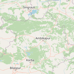
Use this park location map to pinpoint Betla National Park in India, understand its exact geographic position, and read its mapped placement within the surrounding landscape more clearly.

Pigeon | © OpenStreetMap contributors

Location context for Betla National Park

JharkhandLatehar districtPalamu district
Park atlas

Compare protected landscapes across Eastern India, tracing regional park geography and conservation efforts.

Discover National Parks and Protected Areas Surrounding Betla National Park
After exploring Betla National Park, browse other national parks and protected areas situated in Jharkhand and the wider Eastern India region. This geographic view provides essential regional context, allowing for a broader comparison of diverse landscapes, wildlife habitats, and conservation strategies across adjacent protected areas.
Wildlife reserveChhattisgarh

Guru Ghasidas - Tamor Pingla Tiger Reserve: Wildlife Reserve in Chhattisgarh's Mapped Landscapes

Explore protected area geography and regional context.

Guru Ghasidas - Tamor Pingla Tiger Reserve, identified as a wildlife reserve, offers detailed insight into its protected landscape and geographic positioning within Chhattisgarh. Users can explore its mapped boundaries and understand its contribution to the region's natural terrain. This resource focuses on the atlas-style discovery of protected areas, providing a clear picture of the reserve's environmental context and regional significance without delving into visitor logistics.

Area
2,829.38 km²
Established
2024
IUCN
II
Relief
Mixed relief
National parkMadhya Pradesh

Sanjay National Park: Madhya Pradesh Protected Area with Hilly Terrain and Dry Deciduous Forests

Explore the mapped boundaries and landscape context of this national park.

Sanjay National Park, situated in Madhya Pradesh, India, is a substantial protected area recognized for its significant role in conservation. The park features a landscape dominated by hilly terrain and extensive dry deciduous forests, bisected by the Banas River. As a national park and tiger reserve, its mapped geography supports a rich ecosystem and is vital for understanding the protected lands of central India.

Area
1,674.55 km²
Established
1981
IUCN
II
Relief
Highland
Watercolor illustration showing a landscape with trees, water, and mountains
National parkMayurbhanj district

Simlipal National Park: National Park Protected Area in Mayurbhanj District

Mapped boundaries and regional geography of Simlipal National Park.

Simlipal National Park stands as a prominent national park, offering a rich protected area landscape within Mayurbhanj district, India. This entry provides detailed atlas-style information, focusing on the park's geographic footprint and mapped terrain. Explore the structured data that defines Simlipal National Park's identity as a protected natural landscape, ideal for understanding its place within regional geography and conservation efforts.

Area
2,750 km²
Established
1980
IUCN
II
Relief
Mountain
National parkUmaria district

Bandhavgarh National Park: A Protected Landscape in India's Umaria District

Explore the geographic boundaries and mapped terrain.

Bandhavgarh National Park is a designated national park offering a unique glimpse into India's protected landscapes. Located within Umaria district, its geographic features and mapped terrain provide valuable context for atlas exploration. Understanding the park's protected area status and its place within the regional geography is key to appreciating its role as a vital natural landscape.

Area
105 km²
Established
1968
IUCN
II
Visitors
176.1K annual
National parkMadhya Pradesh

Ghughua Fossil Park National Park: Mapped Geography and Protected Area Context in Madhya Pradesh

Explore the mapped boundaries and regional landscape of Ghughua Fossil Park.

Ghughua Fossil Park stands as a designated national park within the expansive geography of Madhya Pradesh, India. This resource facilitates a detailed exploration of its protected landscape, offering insights into its geographic setting and the significance of its mapped boundaries. Understand the park's place within the regional atlas and its role as a key conservation territory.

Area
0.3 km²
Established
1983
IUCN
II
Access
Access unknown
National parkWest Champaran District

Valmiki National Park: A Vital National Park and Protected Landscape in Bihar

Explore unique Sivalik terrain and mapped protected area boundaries

Valmiki National Park, located in the West Champaran District of Bihar, is a significant protected area renowned for its unique geography. Situated at the interface of the Himalayas and the Gangetic plains, the park showcases a varied terrain including ridges, gorges, dense forests, and extensive wetlands. As Bihar's only national park and a designated tiger reserve, it offers rich insights into conservation landscapes and regional biodiversity for atlas exploration.

Area
898.45 km²
Established
1990
IUCN
II
Relief
Mixed relief
National parkNepal

Parsa National Park: Mapped Protected Landscape Within Nepal's Geography

Explore its national park status and geographic setting.

Parsa National Park represents a significant protected area within the geographic framework of Nepal. This page provides critical atlas context, detailing the park's mapped boundaries and its role as a national park. It serves as an essential resource for understanding the specific landscape features and regional geographic positioning of Parsa National Park, contributing to a structured view of protected lands across South Asia.

Area
627.39 km²
Established
2017
IUCN
II
Relief
Lowland
National parkMadhya Pradesh

Kanha National Park: A Madhya Pradesh Protected Landscape for Atlas Exploration

Mapped park boundaries and regional geographic context.

Kanha National Park serves as a vital protected area, offering critical insights into India's natural geography. This entry facilitates detailed atlas-style exploration of its mapped landscape and protected territory within Madhya Pradesh. Understand the park's geographic definition and its role within the broader context of India's conservation lands, providing a foundation for structured geographic discovery.

Area
940 km²
Established
1955
IUCN
II
Visitors
213.8K annual

Common questions about visiting, size, designation, and location context for Betla National Park

Betla National Park FAQs for park facts, access, geography, and protected area context
Find quick answers about Betla National Park, including protected-area facts, park geography, trail and visitor context, and how the park fits into its surrounding country and regional landscape.
MoriAtlas Explorer

Continue Your Protected Areas Search Across the Global Atlas

Deepen your exploration by continuing the structured search for national parks and protected areas worldwide. Utilize the comprehensive filtering capabilities to compare different conservation landscapes and refine your understanding of global park geography. Discover more about the distribution and characteristics of protected natural areas.

Global natural geography