Mori Atlas logo
National parkSimlipal National Park

Mapping the protected landscape boundaries of Simlipal National Park in Mayurbhanj district.

Simlipal National Park: India's National Park Protected Area and Geographic Atlas

(Śimḷipāḷ Jātīya Udyāna)

Simlipal National Park represents a significant protected area within India's natural landscape, located in the Mayurbhanj district. This canonical page offers an atlas-style exploration of the park's geographic identity, mapped boundaries, and its regional context. Understand the protected land's placement and unique landscape characteristics through structured data and geographic insights, providing a comprehensive view for serious atlas exploration and discovery.

Tiger ReserveUNESCO Biosphere ReserveDeciduous ForestWaterfallEastern IndiaElephant Habitat
Stylized illustration of a mountainous landscape featuring waterfalls, river, and forested areas

Simlipal National Park

National park

Park overview

Structured park overview, official facts, and landscape profile for Simlipal National Park

Simlipal National Park park facts, protected area profile, and essential visitor context
Review the core facts for Simlipal National Park, including designation, size, terrain, visitor scale, habitats, and operating context in one park-focused overview.

About Simlipal National Park

Simlipal National Park represents one of India's most important protected areas, serving as a critical stronghold for biodiversity in eastern India. Located in the Mayurbhanj district of Odisha, the park encompasses a diverse landscape of steep hills, plateaus, valleys, and forested plains that support remarkable ecological diversity. The reserve was formally established under Project Tiger in 1973 and has since evolved to include national park status, wildlife sanctuary designations, and ultimately recognition as a UNESCO Biosphere Reserve in 2009. The park's forest ecosystem is characterized by moist deciduous vegetation dominated by sal trees, interspersed with grasslands and savannas that provide crucial grazing habitat for large herbivores. The Simlipal Elephant Reserve connects three protected areas, creating a substantial conservation landscape that supports viable populations of elephants, tigers, and other keystone species. The park's isolation from other tiger reserves has created unique genetic challenges, with the tiger populationdescended from just four individuals in 2014, leading to the distinctive pseudo-melanistic trait that has become a defining characteristic of Simlipal's tiger population.

Quick facts and research context for Simlipal National Park

Simlipal National Park is located in Mayurbhanj district, Odisha, India, approximately 2,750 square kilometers in extent with a core zone of about 1,195 square kilometers. The reserve features significant elevation variation, with peaks reaching 1,178 meters at Khairiburu and 1,158 meters at Meghasani. Two prominent waterfalls, Barehipani at 217 meters and Joranda at 181 meters, add to the park's dramatic landscape. The area experiences a tropical climate with summer temperatures reaching 40°C and winter temperatures dropping to around 14°C. The park is home to approximately 30 tigers as of 2025 and supports 42 mammal species, 242 bird species, and 30 reptile species. The distinctive feature of Simlipal's tiger population is the unusually high occurrence of pseudo-melanism, where roughly 37% of tigers display a predominantly black coat due to this genetic trait.

Park context

Deeper park guide and search-rich context for Simlipal National Park

Simlipal National Park history, landscape, wildlife, and travel context
Explore Simlipal National Park through its history, landscape character, ecosystems, wildlife, conservation priorities, cultural context, and seasonal travel timing in a structured park guide built for atlas discovery and search intent.

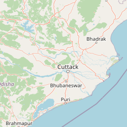
Why Simlipal National Park stands out

Simlipal National Park is best known for its population of pseudo-melanistic tigers, a rare genetic phenomenon where tigers display predominantly black coats instead of the typical orange with black stripes. This trait affects approximately 37% of the park's tiger population and has attracted significant scientific interest due to the genetic isolation of Simlipal's tigers from other tiger populations in India. The park is also recognized for its role as a critical elephant habitat within the Mayurbhanj Elephant Reserve and for its designation as a UNESCO Biosphere Reserve, placing it among India's select group of internationally recognized protected areas. The stunning waterfalls of Barehipani and Joranda, among the tallest in Odisha, further distinguish this park as a destination of both ecological and scenic significance.

Close-up of a white tiger with black stripes lying on grass and dirt ground
White tiger with distinct black stripes resting on the ground

Simlipal National Park history and protected-area timeline

Simlipal's history as a protected area begins with its origins as a royal hunting ground during the rule of local kingdoms. The formal protection journey began in May 1973 when the area was designated as a tiger reserve under Project Tiger, India's flagship conservation initiative. The Government of Odisha declared Simlipal a wildlife sanctuary in 1979 with an initial area of approximately 2,200 square kilometers. In 1980, the state government proposed designating 303 square kilometers as a national park, and by 1986, the national park area was expanded to 845.70 square kilometers. The Government of India declared Simlipal a biosphere reserve in 1994, and UNESCO added it to the World Network of Biosphere Reserves in May 2009. A significant development in the park's management occurred in December 2013 when 32 families from the Kharia tribe were relocated from the core area, followed by the relocation of Jamunagarh village in September 2015. These efforts aimed to reduce human-wildlife conflict and allow the core area to function more effectively as tiger habitat. In 2024, conservationists introduced two female tigers from Tadoba-Andhari Tiger Reserve to address genetic diversity concerns in the isolated population.

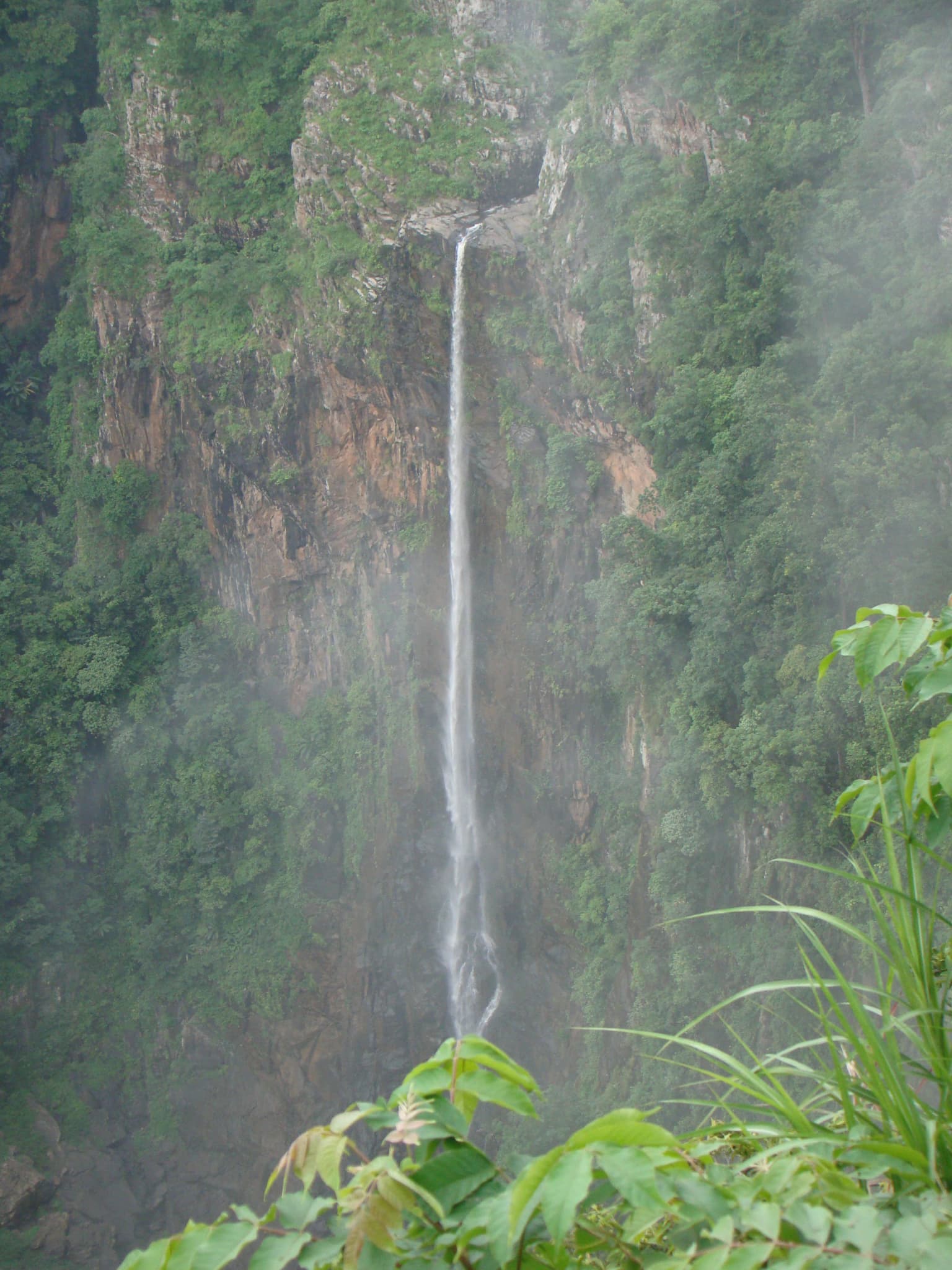
Simlipal National Park landscape and geographic character

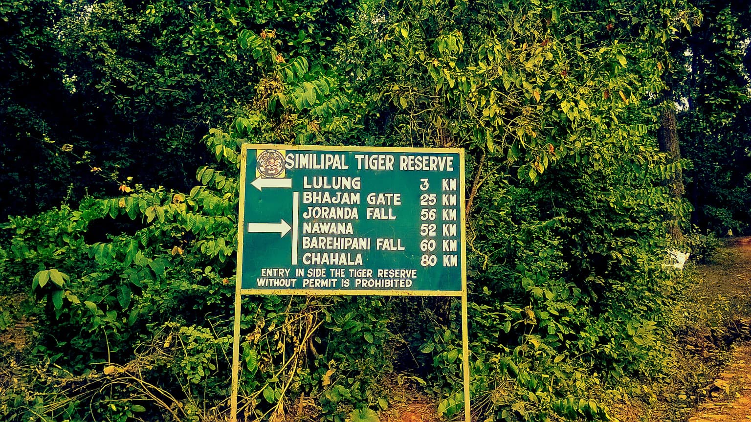
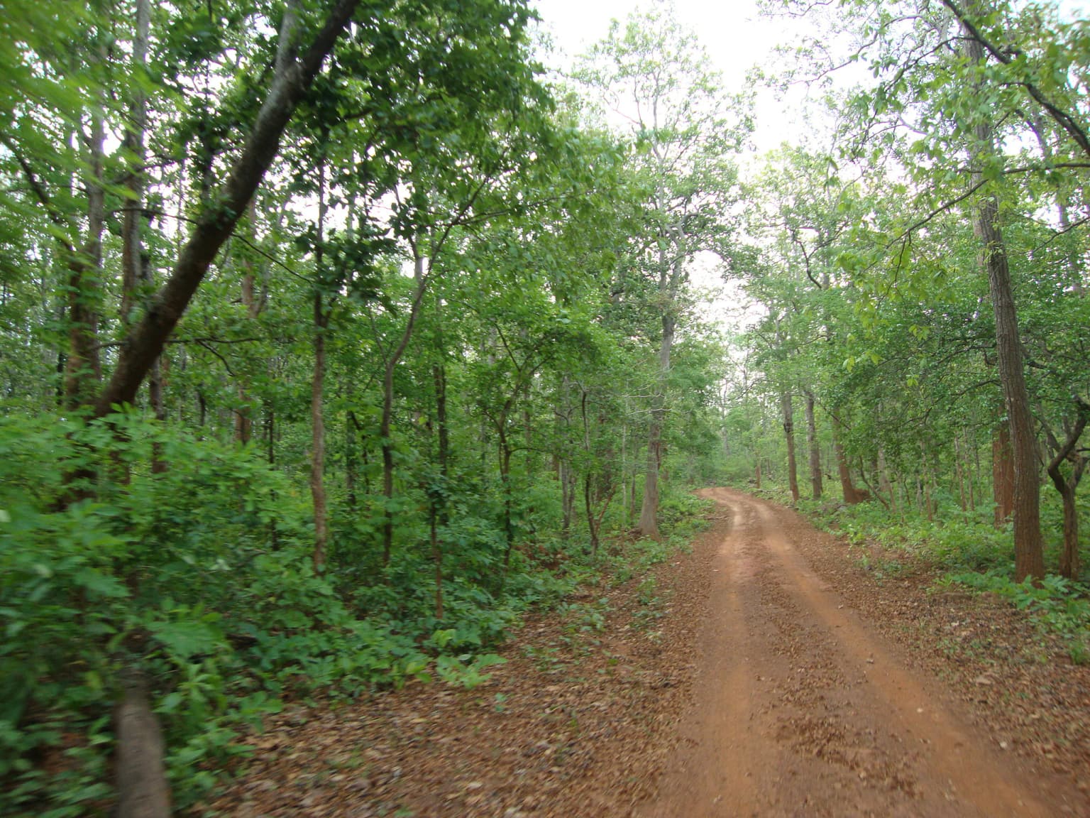
The landscape of Simlipal National Park features a dramatic combination of highlands, steep valleys, and forested plains that create a visually striking and ecologically diverse environment. The reserve encompasses several notable peaks, with Meghasani (also known as Tunkiburu) rising to 1,165 meters as the highest point, followed by Khairiburu at over 1,000 meters elevation. The terrain is characterized by the Southern zone containing the highland core region with peaks like Meghasani and Khariburu, while the Northern zone features gradually sloping mountains and destinations such as the Barehipani and Joranda waterfalls. The park is dissected by at least twelve rivers, including the Budhabalang a, Kharkai, and Deo rivers, which provide crucial water resources for both wildlife and local communities. The two spectacular waterfalls, Barehipani at 217 meters and Joranda at 181 meters, rank among the tallest in Odisha and are actively promoted as tourism attractions. The average elevation throughout the reserve hovers around 900 meters, creating a pleasant climate and diverse habitat zones that transition from moist deciduous forests at lower elevations to higher altitude vegetation communities.

Two brown elephants standing in a grassy area near a body of water with dense green forest in the background
Two Indian elephants standing near a water body in a forested landscape

Simlipal National Park ecosystems, habitats, and plant life

Simlipal National Park supports an exceptionally rich ecological environment within the Eastern Highlands moist deciduous forests ecoregion. The park contains approximately 1,076 plant species across 102 families, including 96 identified orchid species, making it a significant center of plant diversity in eastern India. The vegetation types include tropical moist broadleaf forest, tropical moist deciduous forests, dry deciduous hill forest, and high-level sal forests, with extensive grasslands and savannas interspersed throughout. The forest ecosystem supports remarkable biodiversity at multiple trophic levels, from towering sal trees to countless herbaceous species in the understory. The buffer zones around the core protected area show higher herb and shrub diversity but lower tree diversity, indicating anthropogenic disturbance, while the core areas maintain more intact forest structure with greater tree density and basal area. The park's ecological significance extends to its role as a watershed area, with numerous streams and rivers originating from the highlands and flowing through the forested landscape.

Green directional signboard for Simlipal Tiger Reserve with distances to park locations, surrounded by dense forest vegetation
Signboard showing directions within Simlipal National Park

Simlipal National Park wildlife and species highlights

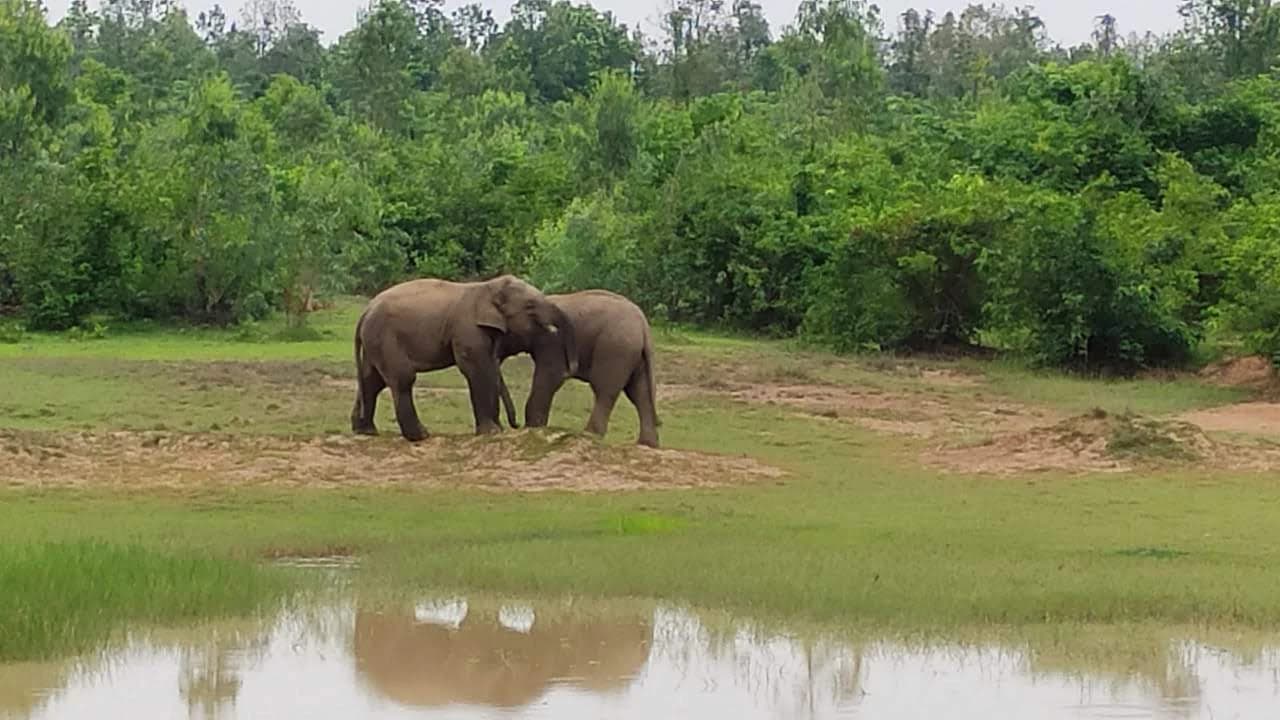
Simlipal National Park supports impressive wildlife diversity with 42 mammal species, 242 bird species, and 30 reptile species recorded within its boundaries. The flagship mammals include Bengal tigers, Asian elephants, gaur (Indian bison), and chausingha (four-horned antelope). The park is particularly renowned for its tiger population, which as of 2025 numbers approximately 30 individuals. The most distinctive feature of Simlipal's tigers is the high occurrence of pseudo-melanism, a genetic trait affecting about 37% of the population that results in tigers with predominantly black coats rather than the typical orange with black stripes. Other notable mammals include leopards, sambar deer, barking deer, jungle cats, wild boars, giant squirrels, and common langurs. The bird fauna is equally diverse, with 231 species known to nest in the forests, including red junglefowl, hill mynahs, peafowl, various parakeets, serpent eagles, hornbills, and trogons. Reptile populations include several snake species and turtles, while the Mugger Crocodile Management Programme has successfully supported populations of mugger crocodiles in the Khairi river.

A dirt road surrounded by dense green trees and foliage in a forested area
Dirt trail winding through dense forest vegetation

Simlipal National Park conservation status and protection priorities

Simlipal National Park holds significant conservation importance as one of India's designated tiger reserves under Project Tiger and as a UNESCO Biosphere Reserve since 2009. The park represents a critical tiger habitat in eastern India, though the population faces unique challenges due to its genetic isolation from other tiger populations. The pseudo-melanistic trait, while scientifically interesting, results from inbreeding and reduced genetic diversity following a population bottleneck where only four tigers remained in 2014. Conservation efforts in 2024 included the introduction of two female tigers from Tadoba-Andhari Tiger Reserve to strengthen the gene pool. The park's status as part of the Mayurbhanj Elephant Reserve provides protection for Asian elephants, another keystone species. Ongoing challenges include human-wildlife conflict, the presence of villages within the core area, and the need to balance conservation with the livelihood needs of local tribal communities who have historically inhabited the region.

Simlipal National Park cultural meaning and human context

Simlipal National Park is home to approximately 10,000 people living in 61 villages within the forest area, predominantly from tribal communities including the Kharia and Ho peoples. These communities have historically lived in close connection with the forest ecosystem, relying on medicinal and aromatic plants for traditional practices and earnings. The presence of human settlements within the protected area presents ongoing challenges for conservation management, as evidenced by the relocation of several villages including Upper Barhakamuda, Bahaghar, and Jamunagarh from the core tiger reserve area. Some relocated tribal communities have raised concerns about the process, claiming that relocations have been forced and seeking recognition of their rights under the Forest Rights Act. The Simlipal Elephant Reserve was established recognizing both the ecological significance of the area and the traditional land use patterns of local tribal communities.

A tall waterfall cascading down a rocky cliff face surrounded by dense green vegetation
Joranda Waterfall in Simlipal National Park

Top sights and standout views in Simlipal National Park

Simlipal National Park stands out for its combination of ecological significance and unique natural features. The park's pseudo-melanistic tigers represent a rare genetic phenomenon found in no other tiger reserve in India, making it a destination of international scientific interest. The dramatic waterfalls of Barehipani and Joranda, among the tallest in Odisha, provide stunning natural scenery within the protected landscape. As a UNESCO Biosphere Reserve since 2009, Simlipal represents India's commitment to balancing conservation with sustainable development. The park's substantial elephant population within the Mayurbhanj Elephant Reserve creates one of the largest protected corridors for Asian elephants in eastern India. The rich botanical diversity, including 96 orchid species and extensive sal forests, supports intricate ecological relationships that sustain diverse wildlife communities.

Best time to visit Simlipal National Park

The best time to visit Simlipal National Park is during the winter months from October through March when temperatures are moderate and wildlife viewing opportunities are optimal. Winter temperatures can drop to around 14°C, making comfortable exploration possible, while the dry season conditions concentrate animals around remaining water sources, enhancing sighting opportunities. The summer months from April to June bring extreme heat with temperatures reaching 40°C and become increasingly difficult for wildlife observation. The monsoon season from July to September brings heavy rainfall that can restrict access to certain areas of the park. Visitors should be aware that Simlipal falls within a high-risk zone for cerebral malaria, and appropriate preventive health measures should be taken before planning a trip.

Park location guide

Geography guide, regional context, and park location map for Simlipal National Park

Simlipal National Park park geography, regions, and map view in India
Understand where Simlipal National Park sits in India through a broader geographic reading of the surrounding landscape, nearby location context, and its mapped position within the national park landscape.

How Simlipal National Park fits into India

India is a South Asian country bordered by the Indian Ocean, Arabian Sea, and Bay of Bengal. It shares land borders with Pakistan, China, Nepal, Bhutan, Bangladesh, and Myanmar. The country has a population of over 1.4 billion people and operates as a federal parliamentary republic with its capital in New Delhi.

Wider geography shaping Simlipal National Park in India

India occupies the Indian subcontinent in South Asia, bordered by the Arabian Sea to the southwest, the Bay of Bengal to the southeast, and the Indian Ocean to the south. It shares land borders with Pakistan to the west, China, Nepal, and Bhutan to the north, and Bangladesh and Myanmar to the east. The territory also includes the Andaman and Nicobar Islands in the Indian Ocean.

Map view of Simlipal National Park

Use this park location map to pinpoint Simlipal National Park in India, understand its exact geographic position, and read its mapped placement within the surrounding landscape more clearly.

Pigeon | © OpenStreetMap contributors

Location context for Simlipal National Park

Mayurbhanj districtOdisha

A Visual Guide to Simlipal's Diverse Habitats, Waterfalls, and Forest Environments

Explore Simlipal National Park: Photos of its Landscapes and Protected Area Scenery
Browse comprehensive photos capturing the diverse terrain and ecological features of Simlipal National Park, an expansive protected area in Odisha, India. Visually understand its moist deciduous forests, dramatic highlands, cascading waterfalls, and critical elephant habitats, revealing the true character of this UNESCO Biosphere Reserve.

Close-up of a white tiger with black stripes lying on grass and dirt ground

A mountain landscape with dense green vegetation, a calm lake in the foreground, and trees under a partly cloudy sky

Two brown elephants standing in a grassy area near a body of water with dense green forest in the background

Green directional signboard for Simlipal Tiger Reserve with distances to park locations, surrounded by dense forest vegetation

A dirt road surrounded by dense green trees and foliage in a forested area

A tiger with orange and black stripes walking on a grassy path at night with dark vegetation in the background

A tall waterfall cascading down a rocky cliff face surrounded by dense green vegetation

Park atlas

Compare surrounding national parks and trace the geographic spread of Eastern India's conservation landscapes.

Discover Nearby Protected Landscapes and National Parks Around Simlipal National Park
Browse a curated list of national parks and protected areas located geographically near Simlipal National Park, encompassing diverse forest ecosystems and critical wildlife habitats across Eastern India. Deepen your atlas-style exploration by comparing the unique conservation features, landscape formations, and regional context of these adjacent protected areas.
National parkKendrapara district

Bhitarkanika National Park: Protected National Park in Kendrapara District

Explore its mapped boundaries and regional landscape.

Bhitarkanika National Park, a designated national park in India's Kendrapara district, offers a unique opportunity for geographic discovery. This page details the park's protected area status, its specific landscape characteristics, and its position within the regional geography. Engage with structured data about its mapped boundaries and understand its environmental context for comprehensive atlas exploration.

Area
145 km²
Established
1998
IUCN
II
Relief
Lowland
Watercolor painting showing mangrove trees, water channels, and hills in the background
National parkWest Bengal

Sundarbans National Park: UNESCO World Heritage Mangrove National Park in West Bengal

Explore its tidal geography and mapped protected boundaries.

Sundarbans National Park is a vital protected area on the Ganges Delta, recognized globally as the world's largest mangrove forest and a UNESCO World Heritage Site. Located in West Bengal, this national park features a unique estuarine geography characterized by intricate tidal channels and distributaries that define its landscape. Its protected boundaries safeguard a complex ecosystem, offering rich opportunities for atlas-driven exploration of its distinctive natural terrain and coastal wetland significance.

Area
1,330.1 km²
Established
1984
IUCN
II
Relief
Lowland
National parkJharkhand

Betla National Park: National Park Protected Area Exploration and Geographic Context in Jharkhand

Mapped boundaries of a significant protected landscape.

Betla National Park, situated in Jharkhand, India, is a key national park offering significant value for geographic and protected-area discovery. This resource facilitates exploration of its mapped boundaries, providing a clear understanding of its protected landscape and its relationship to the surrounding regional geography. Delve into the structured data to comprehend the park's atlas context and its role as a conserved natural area within India.

Area
226.32 km²
Established
1986
IUCN
II
Access
Moderate access
National parkPatuakhali District

Kuakata National Park: Protected Landscape Identity and Geographic Atlas

Mapped boundaries and regional context within Patuakhali District.

Kuakata National Park is a significant protected area designated as a national park, offering valuable insights into the geography of Patuakhali District. This park detail page provides a structured exploration of its mapped boundaries and protected landscape characteristics, serving as a vital entry point for understanding its place within the larger atlas of global natural sites. Focus on its specific geographic setting and conservation status for detailed discovery.

Area
16.13 km²
Established
2010
IUCN
II
Relief
Lowland
Wildlife reserveChhattisgarh

Guru Ghasidas - Tamor Pingla Tiger Reserve: Wildlife Reserve in Chhattisgarh's Mapped Landscapes

Explore protected area geography and regional context.

Guru Ghasidas - Tamor Pingla Tiger Reserve, identified as a wildlife reserve, offers detailed insight into its protected landscape and geographic positioning within Chhattisgarh. Users can explore its mapped boundaries and understand its contribution to the region's natural terrain. This resource focuses on the atlas-style discovery of protected areas, providing a clear picture of the reserve's environmental context and regional significance without delving into visitor logistics.

Area
2,829.38 km²
Established
2024
IUCN
II
Relief
Mixed relief
Watercolor painting of a river flowing through a valley surrounded by hills and dense green vegetation
National parkNaogaon District

Altadighi National Park: Bangladesh's Protected Wetland Reserve in Naogaon District

Explore its mapped terrain and unique wetland ecosystem.

Altadighi National Park in Naogaon District, Bangladesh, is a protected nature reserve notable for its significant reservoir and wetland environment. Designated as a national park, it plays a crucial role in conserving a distinctive ecosystem within the country's protected landscape network. The park's geography, centered around its large water body, provides vital habitat and offers a unique subject for geographic and atlas-based discovery in northern Bangladesh, distinguishing it from more terrestrial protected areas.

Area
2.641 km²
Established
2011
IUCN
IV
Relief
Lowland
National parkDinajpur District

Dharmapur National Park: Sal Forest Ecosystem and Protected Landscape in Dinajpur District

Mapped geography and birdwatching habitats within northern Bangladesh.

Dharmapur National Park, designated as a national park in Dinajpur District, northern Bangladesh, spans 704.70 hectares across 21 revenue villages. It is characterized by dense Sal forests, a distinctive ecosystem forming the ecological core of the protected area. The landscape features semi-deciduous forest terrain, shaped by the Bijra and Nona rivers, offering riparian zones within its relatively flat geography. This protected forest serves as a significant habitat for numerous bird species and mammals, making it a key point of interest for understanding the region's natural landscape and conservation efforts. Explore its mapped boundaries and geographic significance.

Area
7.047 km²
Established
2021
Relief
Lowland
Climate
Tropical
Watercolor illustration showing a landscape with mountains, green fields, and a body of water
National parkDinajpur District

Ramsagar National Park: National Park Protected Area & Geographic Discovery

Explore mapped boundaries and regional landscape context.

Understand Ramsagar National Park as a protected national park within Dinajpur District, Bangladesh. This detail entry provides essential geographic context, outlining the park's mapped protected boundaries and its significance within the regional landscape. It serves as a foundational point for exploring the park's specific natural terrain and its place in a global atlas of conservation lands.

Area
0.278 km²
Established
2001
IUCN
IV
Relief
Lowland

Common questions about visiting, size, designation, and location context for Simlipal National Park

Simlipal National Park FAQs for park facts, access, geography, and protected area context
Find quick answers about Simlipal National Park, including protected-area facts, park geography, trail and visitor context, and how the park fits into its surrounding country and regional landscape.
MoriAtlas Explorer

Continue Your Protected Areas Search Across the Global Atlas

Deepen your exploration by continuing the structured search for national parks and protected areas worldwide. Utilize the comprehensive filtering capabilities to compare different conservation landscapes and refine your understanding of global park geography. Discover more about the distribution and characteristics of protected natural areas.

Global natural geography