Mori Atlas logo
National parkKuakata National Park

Understand the mapped boundaries and protected landscape of Kuakata National Park.

Kuakata National Park: National Park Designation and Geographic Context in Patuakhali District

Kuakata National Park represents a key protected area within the geographic region of Patuakhali District, Bangladesh. As a designated national park, its protected landscape identity is central to understanding regional conservation efforts and the broader atlas of natural areas. Explore the mapped geography and distinct features that define Kuakata National Park, offering a foundation for detailed geographic and protected-area discovery.

coastal ecosystemsmangrove forestsvulture conservationdelta landscapeIUCN Category IInational park

Kuakata National Park

National park

Park overview

Structured park overview, official facts, and landscape profile for Kuakata National Park

Kuakata National Park park facts, protected area profile, and essential visitor context
Review the core facts for Kuakata National Park, including designation, size, terrain, visitor scale, habitats, and operating context in one park-focused overview.

About Kuakata National Park

Kuakata National Park represents an important addition to Bangladesh's network of protected areas, established in 2010 to safeguard coastal ecosystems and wildlife in the country's southern delta region. The park is situated in Patuakhali District, an area characterized by its complex network of rivers, tidal channels, and mangrove forests that form part of the broader Sundarbans ecosystem. As an IUCN Category II protected area, the park is managed with the dual goals of biodiversity conservation and sustainable nature-based tourism. The designation as a vulture safe zone under Bangladesh's Vulture Safe Zone-2 Schedule indicates specific conservation measures are in place to protect these scavenger species, which have suffered dramatic population declines due to veterinary drug toxicity. The park's establishment reflects Bangladesh's commitment to expanding its protected area network to cover representative ecosystems across the country, with particular attention to coastal and wetland habitats that support significant biodiversity.

Quick facts and research context for Kuakata National Park

Kuakata National Park is located in Kalapara Upazila of Patuakhali District in southern Bangladesh, positioned along the Bay of Bengal coastline within the extensive Ganges Delta. The park spans 1613 hectares of protected coastal and forested land. It was established as a national park on 24 October 2010 by official government declaration, with the primary objectives of conserving flora and fauna, preserving natural ecosystems, and supporting sustainable tourism development. The area is classified under IUCN Category II as a national park and additionally functions as a nature reserve. A notable conservation feature is its designation as a vulture safe zone, reflecting Bangladesh's efforts to protect and conserve populations of these declining birds of prey.

Park context

Deeper park guide and search-rich context for Kuakata National Park

Kuakata National Park history, landscape, wildlife, and travel context
Explore Kuakata National Park through its history, landscape character, ecosystems, wildlife, conservation priorities, cultural context, and seasonal travel timing in a structured park guide built for atlas discovery and search intent.

Why Kuakata National Park stands out

Kuakata National Park is best known for its role as a coastal protected area within the Ganges Delta ecosystem and its designation as a vulture safe zone. The park protects important coastal forest and mangrove habitats that are characteristic of this region, which is one of the world's largest delta systems. Its significance as a vulture conservation area distinguishes it from many other protected areas in Bangladesh, as it serves as a declared safe habitat for vulture species that face severe population declines across South Asia. The park's location along the Bay of Bengal also places it within a region of high ecological importance for migratory waterbirds and coastal biodiversity.

Kuakata National Park history and protected-area timeline

Kuakata National Park was officially declared as a national park by the Government of Bangladesh on 24 October 2010. The declaration was part of Bangladesh's broader strategy to strengthen its protected area network and meet biodiversity conservation commitments. The establishment of the park aimed to conserve the natural flora and fauna of the coastal region, protect the coastal ecosystem's integrity, and facilitate the development of sustainable tourism facilities in the area. Prior to its national park designation, the area functioned as a nature reserve with various levels of protection. The selection of this particular area for national park status reflected its ecological importance, particularly for coastal bird species and the vulture populations that would later earn the area its safe zone designation. The park's creation added to Bangladesh's collection of national parks, which serve as the backbone of the country's terrestrial protected area system.

Kuakata National Park landscape and geographic character

The landscape of Kuakata National Park is defined by its coastal setting within the Ganges Delta, one of the world's largest river deltas. The terrain consists of low-lying coastal plain with tidal influences from the Bay of Bengal. The area features mangrove forests, tidal waterways, and patches of deciduous forest that characterize the interface between terrestrial and marine environments in this region. The soil composition reflects deltaic sediments with high moisture content due to tidal and groundwater influence. The landscape supports a mix of coastal vegetation types adapted to saline and brackish water conditions, including various mangrove species and associated coastal plants. The proximity to the Bay of Bengal ensures that the park experiences typical coastal climate patterns with monsoonal influences.

Kuakata National Park ecosystems, habitats, and plant life

The ecological character of Kuakata National Park centers on its coastal and deltaic habitats within the Ganges Delta system. This region supports distinctive vegetation communities adapted to tidal saltwater environments, including mangrove forests that provide critical habitat for numerous species. The park's designation as a vulture safe zone indicates that the surrounding landscape supports sufficient prey populations and suitable roosting habitat for these large birds of prey. The coastal location also positions the area as an important zone for migratory waterbirds that utilize the East Asian-Australasian flyway. The delta ecosystem is recognized for its high biological productivity and its role in supporting both resident and migratory species across the Bay of Bengal region.

Kuakata National Park wildlife and species highlights

Kuakata National Park provides habitat for various wildlife species typical of Bangladesh's coastal ecosystems. The park's significance for vultures is particularly notable, as these birds face severe conservation challenges throughout South Asia due to poisoning from veterinary drugs. The vulture safe zone designation indicates that the area supports populations of these scavengers, which rely on finding safe foraging opportunities in landscapes where they are not exposed to toxic substances. Beyond vultures, the coastal forest and mangrove habitats support diverse bird species, small mammals, and reptile populations that occupy the delta's ecological niches. The tidal water channels and forest areas create a heterogeneous environment that supports multiple species across different habitat types.

Kuakata National Park conservation status and protection priorities

The conservation importance of Kuakata National Park derives from several factors that distinguish it within Bangladesh's protected area system. Its designation as a vulture safe zone places it within a network of protected areas specifically managed to support the recovery of vulture populations that have declined by over 99 percent across South Asia since the 1990s. The park's coastal ecosystems are intrinsically valuable as they protect transitional environments between terrestrial and marine systems, providing ecosystem services including coastal protection, carbon storage, and biodiversity maintenance. As an IUCN Category II protected area, the park receives formal recognition of its national park status, which guides management approaches toward both biodiversity conservation and compatible sustainable use. The establishment of the park contributes to Bangladesh's progress in representing its diverse ecological zones within its protected area network.

Kuakata National Park cultural meaning and human context

Kuakata National Park exists within a region of Bangladesh where human communities have long interacted with the coastal delta environment. The Ganges Delta is one of the world's most densely populated rural areas, with communities historically dependent on fishing, agriculture, and forest resource use. The establishment of the protected area operates within this context of ongoing human presence and activity in the surrounding landscape. The park's name Kuakata derives from local usage, and the Bengali name কুয়াকাটা জাতীয় উদ্যান reflects the area's identity within Bengali linguistic and cultural traditions. The development of tourism facilities was identified as an objective at the park's establishment, indicating recognition that the protected area exists within a broader regional context of communities who may participate in and benefit from nature-based tourism activities.

Top sights and standout views in Kuakata National Park

Kuakata National Park stands out as a coastal protected area in the Ganges Delta with specific conservation value for vultures, making it an important component of Bangladesh's vulture safe zone network. The park offers access to coastal forest ecosystems that are characteristic of this delta region, with mangrove vegetation and tidal landscapes providing distinctive scenery. Its establishment in 2010 reflects relatively recent conservation investment in protecting Bangladesh's coastal biodiversity. The combination of coastal ecosystem protection and specific vulture conservation makes this park distinctive among Bangladesh's protected areas, as it addresses both broader habitat conservation goals and targeted species recovery needs.

Best time to visit Kuakata National Park

The optimal time to visit Kuakata National Park aligns with Bangladesh's cool dry season from November through February, when weather conditions are most comfortable for outdoor exploration. This period offers milder temperatures and lower humidity compared to the hot summer months, making it more suitable for wildlife observation and park exploration. The monsoon season from June to September brings heavy rainfall to the delta region, which can affect accessibility and visibility within the park. Visitors interested in birdwatching may find the winter months particularly rewarding, as many migratory waterbirds are present in the coastal areas during this period. The park's coastal location means that weather patterns are influenced by both monsoonal rainfall and the bay's tidal patterns.

Park location guide

Geography guide, regional context, and park location map for Kuakata National Park

Kuakata National Park park geography, regions, and map view in Bangladesh
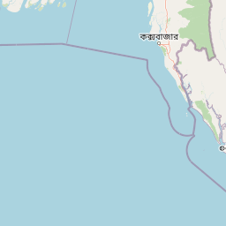
Understand where Kuakata National Park sits in Bangladesh through a broader geographic reading of the surrounding landscape, nearby location context, and its mapped position within the national park landscape.

How Kuakata National Park fits into Bangladesh

Bangladesh, officially the People's Republic of Bangladesh, is a South Asian country known for its high population density and deltaic geography formed by the Ganges-Brahmaputra river system. It gained independence from Pakistan in 1971 following a liberation war. The country operates as a unitary parliamentary republic with Dhaka as its capital and largest city, while Chittagong serves as the second-largest city and main port.

Wider geography shaping Kuakata National Park in Bangladesh

Bangladesh occupies the delta region at the confluence of the Ganges, Brahmaputra, and Meghna rivers in South Asia. The country shares land borders with India to the north, west, and east, and Myanmar to the southeast, while its southern boundary is along the Bay of Bengal. The terrain is predominantly low-lying deltaic plain, making it susceptible to flooding. The country is separated from Bhutan and Nepal by the Siliguri Corridor and from China by the Indian state of Sikkim.

Map view of Kuakata National Park

Use this park location map to pinpoint Kuakata National Park in Bangladesh, understand its exact geographic position, and read its mapped placement within the surrounding landscape more clearly.

Pigeon | © OpenStreetMap contributors

Location context for Kuakata National Park

Patuakhali District
Park atlas

Trace the geographic spread of protected areas and coastal ecosystems surrounding Kuakata National Park within the Ganges Delta region.

Discover Nearby Protected Areas and Coastal Landscapes Similar to Kuakata National Park
Discover other national parks and protected areas located in proximity to Kuakata National Park, mapping the unique coastal ecosystems and deltaic terrain of southern Bangladesh. Compare these regional conservation landscapes to trace the geographic spread of protected habitats, offering insight into their varied ecological significance across the Ganges Delta.
National parkBangladesh

Nijhum Dweep National Park: A Protected Landscape in Bangladesh's Geographic Atlas

Explore the mapped boundaries and regional setting of this national park.

Nijhum Dweep National Park is a key protected area situated within the deltaic geography of Bangladesh. This detailed entry provides insight into its mapped landscape, natural terrain, and its significance as a national park. Understand its geographic context and explore its protected boundaries as part of a broader atlas of natural areas, offering a factual basis for understanding this unique South Asian landscape.

Area
163.52 km²
Established
2001
IUCN
IV
Relief
Lowland
Watercolor painting showing mangrove trees, water channels, and hills in the background
National parkWest Bengal

Sundarbans National Park: UNESCO World Heritage Mangrove National Park in West Bengal

Explore its tidal geography and mapped protected boundaries.

Sundarbans National Park is a vital protected area on the Ganges Delta, recognized globally as the world's largest mangrove forest and a UNESCO World Heritage Site. Located in West Bengal, this national park features a unique estuarine geography characterized by intricate tidal channels and distributaries that define its landscape. Its protected boundaries safeguard a complex ecosystem, offering rich opportunities for atlas-driven exploration of its distinctive natural terrain and coastal wetland significance.

Area
1,330.1 km²
Established
1984
IUCN
II
Relief
Lowland
National parkChittagong District

Baroiyadhala National Park: A Vital Wildlife Corridor and Protected Forest Landscape in Bangladesh

Discover its terrain, mapped boundaries, and regional significance.

Baroiyadhala National Park, situated in Bangladesh's Chittagong District, stands as a critical national park dedicated to preserving forest ecosystems and functioning as an essential wildlife corridor. The park's undulating terrain and dense vegetation are vital for supporting threatened species and maintaining habitat connectivity. This page offers an atlas-style exploration of Baroiyadhala National Park, detailing its protected area status, geographic context within the Chittagong region, and its significance for conservation in South Asia, providing a rich understanding of its natural landscape.

Area
29.34 km²
Established
2010
IUCN
II
Climate
Tropical
National parkBangladesh

Himchari National Park: A Protected National Park within Bangladesh's Delta Geography

Mapped protected area and landscape context in South Asia.

Himchari National Park represents a vital protected natural area contributing to the rich geography of Bangladesh. As a national park, it offers users a focal point for understanding mapped landscapes and the distribution of conservation lands within the South Asian delta region. Exploring this entity provides insight into the country's protected areas and their unique environmental settings for structured atlas discovery.

Area
17.29 km²
Established
1980
IUCN
IV
Relief
Upland
National parkCox's Bazar District

Medhakachhapia National Park: Protected Mangrove Landscape and Geography in Cox's Bazar

Mapping the boundaries of a unique coastal Bangladesh National Park.

Medhakachhapia National Park is a distinct protected area in Cox's Bazar District, Bangladesh, renowned for its old-growth Rhizophora apiculata mangrove forest. Spanning approximately 396 hectares, it serves as a crucial habitat and represents a specific type of tropical coastal landscape. This park's designation as a national park highlights its conservation importance, particularly its role in protecting some of Bangladesh's most mature mangrove stands. Explore its geographic context and protected status for a deeper understanding of its natural landscape.

Area
3.959 km²
Established
2008
IUCN
IV
Relief
Lowland
National parkRangamati District

Kaptai National Park: Protected Landscape and Geographic Context in Rangamati District

Explore its mixed evergreen forest and lakeside terrain.

Kaptai National Park is a crucial protected area located in Bangladesh's Rangamati District, renowned for its mixed evergreen forests and unique position adjacent to Kaptai Lake. This detail page provides an atlas-oriented perspective on the park's geographic identity, mapped boundaries, and its role within the diverse Chittagong Hill Tracts region. Understand the terrain, from rolling hills to lakeside environments, and appreciate its conservation significance as a national park.

Area
54.64 km²
Established
1999
IUCN
II
Climate
Subtropical
National parkTripura

Clouded Leopard National Park: National Park Protected Area in Tripura's Forested Landscape

Mapped primate habitat and regional geography in Northeast India.

Clouded Leopard National Park serves as a critical protected area within Tripura, India, focusing on the conservation of its forest ecosystems and primate populations, including the Phayre's langur. As part of the larger Sepahijala Wildlife Sanctuary, its mapped boundaries contribute to the regional protected landscape. This national park offers valuable insight into the natural terrain and biodiversity specific to Northeast India, providing a unique geographic focus for atlas exploration.

Area
5.08 km²
Established
2007
IUCN
II
Climate
Tropical
National parkBangladesh

Bhawal National Park: Mapped Protected Landscape in Bangladesh

Explore its national park designation and regional geography.

Bhawal National Park represents a key protected landscape within Bangladesh. This entry provides detailed information on its identity as a national park, focusing on its mapped geography and protected area significance. Users can explore the park's specific context within the broader South Asian region, understanding its contribution to the nation's conserved natural areas and gaining insight into its landscape character through an atlas-driven perspective.

Area
50.22 km²
Established
1982
IUCN
IV
Relief
Lowland

Common questions about visiting, size, designation, and location context for Kuakata National Park

Kuakata National Park FAQs for park facts, access, geography, and protected area context
Find quick answers about Kuakata National Park, including protected-area facts, park geography, trail and visitor context, and how the park fits into its surrounding country and regional landscape.
MoriAtlas Explorer

Continue Your Protected Areas Search Across the Global Atlas

Deepen your exploration by continuing the structured search for national parks and protected areas worldwide. Utilize the comprehensive filtering capabilities to compare different conservation landscapes and refine your understanding of global park geography. Discover more about the distribution and characteristics of protected natural areas.

Global natural geography