Mori Atlas logo
National parkBidoup Nui Ba National Park

Discover the mapped boundaries and regional natural landscape of this protected area in Lâm Đồng Province.

Bidoup Nui Ba National Park: Protected Landscape Geography and Atlas Context in Vietnam

(Vườn quốc gia Bidoup Núi Bà)

Bidoup Nui Ba National Park stands as a significant protected area within Vietnam's Lâm Đồng Province, representing a vital component of the country's natural heritage. As a designated national park, it offers a unique lens through which to explore the mapped geography and distinct landscape character of the Central Highlands. This detailed atlas entry focuses on the park's boundaries and its integration into the broader regional context, providing a foundation for understanding its protected land status and geographic significance.

Central Highlands VietnamConifer forestsEndangered primatesMountain protected areaBiosphere ReserveHighland plateau

Bidoup Nui Ba National Park

National park

Park overview

Structured park overview, official facts, and landscape profile for Bidoup Nui Ba National Park

Bidoup Nui Ba National Park park facts, protected area profile, and essential visitor context
Review the core facts for Bidoup Nui Ba National Park, including designation, size, terrain, visitor scale, habitats, and operating context in one park-focused overview.

About Bidoup Nui Ba National Park

Bidoup Nui Ba National Park represents one of Vietnam's most significant protected areas, preserving the ecological integrity of the Langbiang plateau in the Central Highlands region. The park's establishment in 2004 formalized protection for a mountainous landscape that had long served as a critical watershed and biodiversity corridor for southern Vietnam. The name itself derives from the two towering peaks that anchor the plateau, with Bidoup standing as the highest point in Lâm Đồng Province. The park's extensive area and varied elevation gradient create diverse habitat conditions, from lower elevation evergreen forests to montane conifer communities at the highest summits. As one of the five largest national parks in Vietnam, Bidoup Nui Ba plays a crucial role in regional conservation strategy, protecting watersheds that support downstream agricultural communities while preserving irreplaceable ecological communities. The integration of the park into the Langbiang Biosphere Reserve in 2015 reflects its international significance as a model of sustainable conservation in a region where development pressures are intense.

Quick facts and research context for Bidoup Nui Ba National Park

The park is situated in Tây Nguyên, Vietnam's Central Highlands region, approximately 35 kilometers from Đà Lạt city. It occupies elevations ranging from 1,400 to 2,287 meters above sea level across the Langbiang plateau. The protected area is managed by the People's Committee of Lâm Đồng Province and is divided into three zones: a strict protection zone covering 28,731 hectares, an ecological recovery zone of 36,059 hectares, and a 10-hectare administrative and service zone. In 2015, the park became part of the Langbiang Biosphere Reserve, recognized by UNESCO.

Park context

Deeper park guide and search-rich context for Bidoup Nui Ba National Park

Bidoup Nui Ba National Park history, landscape, wildlife, and travel context
Explore Bidoup Nui Ba National Park through its history, landscape character, ecosystems, wildlife, conservation priorities, cultural context, and seasonal travel timing in a structured park guide built for atlas discovery and search intent.

Why Bidoup Nui Ba National Park stands out

Bidoup Nui Ba is renowned for its exceptional conifer forest diversity, hosting 14 of Vietnam's 33 conifer species including the rare two-flat-needle leaf pine and Himalayan yew. The park is also significant for its population of endangered primates, particularly the black-shanked douc and yellow-cheeked gibbon, along with a suite of other threatened mammals including the pygmy slow loris, Asiatic black bear, and dhole. The high-altitude Hòn Giao peak, frequently shrouded in mist year-round, supports unique orchid ecosystems that face ongoing conservation challenges.

Bidoup Nui Ba National Park history and protected-area timeline

The national park was officially established in 2004, representing the culmination of conservation efforts that recognized the unique ecological value of the Langbiang plateau. Prior to formal protection, the area had been managed under various designations, but the establishment as a national park provided stronger legal framework for habitat preservation. The year 2015 marked a significant milestone when the Langbiang Biosphere Reserve, encompassing Bidoup Nui Ba, received UNESCO recognition, elevating the park's international profile and bringing additional resources for conservation management. The park is named after the two dominant peaks of the region, a naming convention that honors the natural landmarks that define the local landscape. Management responsibility rests with the People's Committee of Lâm Đồng Province, which oversees the park's operations through its administrative structure.

Bidoup Nui Ba National Park landscape and geographic character

The park occupies the highland terrain of the Langbiang plateau, a mountainous region characterized by steep ridgelines, deep valleys, and two prominent peaks. The elevation range spans from approximately 1,400 meters at the lower boundaries up to 2,287 meters at Bidoup peak, creating substantial topographic variation within the protected area. The terrain is complex, with the Hòn Giao peak standing as another notable high point where cloud formation is common throughout the year, creating a distinctive mist-shrouded environment. The underlying geology supports diverse soil types that in turn sustain the varied forest communities. Rivers and streams originating in the highland area flow outward to supply watersheds that support agriculture throughout the surrounding lowlands.

Bidoup Nui Ba National Park ecosystems, habitats, and plant life

The ecological diversity of Bidoup Nui Ba reflects its position within the Indochinese region and its complex topography. The park contains two primary forest types: coniferous forests and evergreen broadleaf forests. The conifer forests are particularly significant, supporting 14 of Vietnam's 33 documented conifer species, a remarkable concentration that includes endemic and relict species. The vascular plant inventory exceeds 1,933 species, of which 96 are endemic to the area and 62 are listed as rare in the IUCN Red List of Threatened Species. The high-altitude sections support specialized flora adapted to cooler conditions and frequent cloud immersion, while lower elevations transition into tropical forest communities. This vertical zonation creates multiple ecological niches within a relatively compact area.

Bidoup Nui Ba National Park wildlife and species highlights

The vertebrate fauna of Bidoup Nui Ba comprises over 441 species spanning 30 orders and 98 families, representing exceptional biodiversity for a montane protected area. Thirty-two of these species appear in the IUCN Red Book, indicating their global conservation significance. The primate community is particularly notable, featuring the black-shanked douc and yellow-cheeked gibbon as flagship species. Other mammals include the pygmy slow loris, Asiatic black bear, dhole, giant muntjac, and Owston's civet. The bird community includes several endemic species characteristic of the Central Highlands, such as the Assamese treepie, golden-cheeked laughingthrush, and gray-cheeked laughingthrush. The mix of Indochinese and Himalayan faunal elements reflects the park's position at a biogeographic crossroads.

Bidoup Nui Ba National Park conservation status and protection priorities

Bidoup Nui Ba carries significant conservation importance both within Vietnam and regionally. The concentration of rare and endemic species, particularly among conifers and primates, makes it a priority area for biodiversity preservation. The park's inclusion in the Langbiang Biosphere Reserve since 2015 recognizes its role in maintaining ecological processes while supporting sustainable development in the surrounding region. However, the park faces substantial threats including illegal orchid collection from the mist-shrouded peaks, shifting cultivation practices that involve charcoal production, periodic forest fires, and illegal land encroachment for coffee cultivation. Hunting by local communities also pressures wildlife populations. Management focuses on enforcing protection regulations while working with neighboring communities to address underlying drivers of habitat degradation.

Bidoup Nui Ba National Park cultural meaning and human context

The park sits within the cultural landscape of the Central Highlands, home to indigenous communities including the Cơ Ho people. According to local legend, the name Bidoup originates from Cơ Ho language, meaning the lying person, referring to a folktale about the relationship between the two peaks Bidoup and Nui Ba, depicted as an aunt and niece who became the mountain peaks. The region has traditional land use patterns that predate formal protection, and contemporary conservation efforts must balance indigenous community needs with habitat preservation objectives.

Top sights and standout views in Bidoup Nui Ba National Park

The park's dual peaks, Bidoup and Nui Ba, form the most prominent landmarks, with Bidoup being the highest point in Lâm Đồng Province. The Hòn Giao peak, perpetually shrouded in clouds, supports unique orchid communities. The conifer forest diversity is exceptional, with rare species including the two-flat-needle leaf pine, considered a living fossil. Endangered primates including black-shanked douc and yellow-cheeked gibbon inhabit the forest canopies. The integration into the Langbiang Biosphere Reserve confirms international recognition of the park's conservation value.

Best time to visit Bidoup Nui Ba National Park

The optimal period for visiting Bidoup Nui Ba falls during the dry season, typically from November through April, when rainfall is reduced and trail conditions are more favorable. The mountain environment experiences cool temperatures year-round due to the elevation, with the highland climate providing pleasant conditions even during summer months. Visitors interested in wildlife observation should note that dry seasons often concentrate animals around remaining water sources, potentially improving sighting opportunities. The wet season from May through October brings heavier rainfall that can restrict access to higherelevation trails and create challenging conditions for exploration.

Park location guide

Geography guide, regional context, and park location map for Bidoup Nui Ba National Park

Bidoup Nui Ba National Park park geography, regions, and map view in Vietnam
Understand where Bidoup Nui Ba National Park sits in Vietnam through a broader geographic reading of the surrounding landscape, nearby location context, and its mapped position within the national park landscape.

How Bidoup Nui Ba National Park fits into Vietnam

Vietnam, officially the Socialist Republic of Viet Nam, is a unitary communist state in Southeast Asia. It occupies roughly 331,000 square kilometres along the eastern edge of Mainland Southeast Asia, with a population exceeding 102 million. The country is bordered by China to the north, Laos and Cambodia to the west, and has maritime boundaries in the Gulf of Thailand and South China Sea.

Wider geography shaping Bidoup Nui Ba National Park in Vietnam

Vietnam occupies the eastern edge of Mainland Southeast Asia, stretching along the Gulf of Thailand to the southwest and the South China Sea to the east. The country is bordered by China to the north, and Laos and Cambodia to the west. It has a diverse landscape ranging from the Red River Delta in the north to the Mekong Delta in the south.

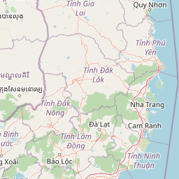
Map view of Bidoup Nui Ba National Park

Use this park location map to pinpoint Bidoup Nui Ba National Park in Vietnam, understand its exact geographic position, and read its mapped placement within the surrounding landscape more clearly.

Pigeon | © OpenStreetMap contributors

Location context for Bidoup Nui Ba National Park

Lâm Đồng ProvinceTây Nguyên
Park atlas

Trace the regional park geography and compare protected landscapes within Vietnam's Central Highlands, extending your discovery from Bidoup Nui Ba.

Explore National Parks and Protected Areas Near Bidoup Nui Ba National Park
Browse other national parks and protected areas situated in Vietnam's Central Highlands, exploring diverse montane ecosystems and regional conservation efforts beyond Bidoup Nui Ba National Park. Compare these protected landscapes to understand their unique geographic spread and conservation features, providing valuable context for your broader atlas exploration.
National parkNinh Thuận Province

Phước Bình National Park: Protected Area Identity and Geographic Setting in Ninh Thuận

Explore Vietnam's Phước Bình National Park and its mapped terrain.

Phước Bình National Park represents a distinct national park entity situated within Ninh Thuận Province, Vietnam. This destination facilitates an atlas-driven understanding of its protected landscape, emphasizing its geographical placement and mapped boundaries. Explore the core identity of this park as a component of Vietnam's protected areas network and its specific regional landscape context.

Area
198.14 km²
Established
2006
IUCN
II
Relief
Mountain
Watercolor illustration of a river, trees, and hills in a natural landscape.
National parkĐắk Lắk Province

Chư Yang Sin National Park: Mapped Protected Landscape in Đắk Lắk Province

Explore its protected boundaries and regional geographic context.

Chư Yang Sin National Park stands as a key protected natural area within Vietnam's Central Highlands. This national park, located in the expansive Đắk Lắk Province, provides a rich subject for geographic discovery. Understanding its mapped boundaries and position within the regional landscape offers valuable context for atlas-based exploration of Vietnam's protected lands.

Area
589.47 km²
Established
2002
IUCN
II
Scope
Terrestrial
National parkĐắk Nông Province

Tà Đùng National Park: Protected Landscape and Geographic Atlas Entry

Mapped Boundaries and Regional Terrain Context

Tà Đùng National Park represents a vital protected landscape within Vietnam's Đắk Nông Province, offering rich opportunities for geographic discovery. This entry details the park's identity as a national park, focusing on its mapped boundaries and its contribution to the regional atlas. Explore the fundamental geographic features and protected land context that define Tà Đùng National Park, facilitating a deeper understanding of its place within the broader natural landscape.

Area
209 km²
Established
2018
IUCN
II
Relief
Mountain
National parkĐắk Lắk Province

Yok Đôn National Park: Vietnam's Expansive Lowland Forest Protected Landscape and Regional Geography

Mapped boundaries within Đắk Lắk Province, part of a transboundary conservation area.

Yok Đôn National Park is Vietnam's largest lowland forest national park, covering approximately 1,155 square kilometers in Đắk Lắk Province. This protected area is characterized by its rare khộp forest ecosystem and serves as a crucial refuge for large mammals. Situated near the Cambodian border, it forms a key component of one of Southeast Asia's largest continuous protected area networks, offering significant insights into regional protected landscape geography and conservation connectivity.

Area
1,155.45 km²
Established
1986
IUCN
II
Relief
Lowland
National parkNinh Thuận Province

Núi Chúa National Park: Protected Landscape and Geographic Atlas Entry

Explore Ninh Thuận Province's national park geography.

Núi Chúa National Park is a key protected area within Vietnam's Ninh Thuận Province, offering vital context for understanding regional geography and mapped natural landscapes. This entry provides the essential geographic details for the park, serving as a foundational element for atlas-based discovery of Vietnam's protected lands. Delve into its mapped boundaries and landscape identity to appreciate its significance.

Area
317.05 km²
Established
2003
IUCN
II
Relief
Mountain
National parkBình Phước Province

Bù Gia Mập National Park: Protected Landscape and Regional Geography in Vietnam

Discover its mapped boundaries and terrain in Bình Phước Province.

Bù Gia Mập National Park is a designated national park in Vietnam, located within the geographical area historically associated with Bình Phước Province. This page focuses on providing a structured understanding of the park's protected land status and its mapped geographic features. Explore the context of this protected landscape, its position within the regional geography, and its role as an element for atlas-based discovery of Vietnam's natural areas.

Area
260.32 km²
Established
2002
IUCN
II
Relief
Upland
National parkRatanakiri province

O'Yadav National Park: Protected Forest Conservation in Ratanakiri Province

Explore mapped boundaries and regional landscape context.

O'Yadav National Park is a national park located in northeastern Cambodia's Ratanakiri province, designated to protect significant forest ecosystems and serve as a vital link in the nation's biodiversity corridor system. Spanning 105,019 hectares, the park encompasses forested terrain and includes the historically significant Yak Nang temple site. Its conservation efforts contribute to the ecological integrity of the broader Indochinese region, making it a key protected landscape for atlas-based geographic study.

Area
1,050.19 km²
Established
2016
IUCN
II
Scope
Terrestrial
Watercolor illustration of a landscape with rolling hills, green vegetation, and a body of water
National parkVietnam

Cát Tiên National Park: Vietnam's Premier Protected Lowland Forest and Wetland Atlas

Explore the mapped boundaries and diverse ecosystems of this vital national park.

Cát Tiên National Park represents a significant ecological reserve in southern Vietnam, covering a vast expanse of lowland tropical forest and critical wetland habitats. The park's landscape is shaped by seasonal flooding from the Dong Nai River, creating unique ecosystems like the renowned Bàu Sấu (Crocodile Lake) and supporting diverse flora and fauna. Understanding Cát Tiên National Park's geography, its protected landscape character, and its position within Vietnam offers valuable insights for atlas-based exploration of Southeast Asia's natural heritage.

Area
720 km²
Established
1992
IUCN
II
Relief
Lowland

Common questions about visiting, size, designation, and location context for Bidoup Nui Ba National Park

Bidoup Nui Ba National Park FAQs for park facts, access, geography, and protected area context
Find quick answers about Bidoup Nui Ba National Park, including protected-area facts, park geography, trail and visitor context, and how the park fits into its surrounding country and regional landscape.
MoriAtlas Explorer

Continue Your Protected Areas Search Across the Global Atlas

Deepen your exploration by continuing the structured search for national parks and protected areas worldwide. Utilize the comprehensive filtering capabilities to compare different conservation landscapes and refine your understanding of global park geography. Discover more about the distribution and characteristics of protected natural areas.

Global natural geography