Mori Atlas logo
National parkTà Đùng National Park

Explore the mapped boundaries and regional setting of this national park in Đắk Nông Province.

Tà Đùng National Park: Protected Landscape Geography and Atlas Context

(Vườn Quốc Gia Tà Đùng)

Tà Đùng National Park stands as a significant protected area, offering a unique lens into the natural geography of Vietnam's Đắk Nông Province. This page provides atlas-level context for Tà Đùng National Park, detailing its protected landscape identity and its place within the regional terrain. Users can investigate the park's mapped boundaries and understand its geographic significance for broader conservation exploration.

National ParkMountain ForestLake IslandsEndemic BirdsCentral HighlandsWetland Reserve

Tà Đùng National Park

National park

Park overview

Structured park overview, official facts, and landscape profile for Tà Đùng National Park

Tà Đùng National Park park facts, protected area profile, and essential visitor context
Review the core facts for Tà Đùng National Park, including designation, size, terrain, visitor scale, habitats, and operating context in one park-focused overview.

About Tà Đùng National Park

Tà Đùng National Park occupies a distinctive position in Vietnam's network of protected areas, situated at the geographic and biological intersection between the South Central Highlands and the Southeast region. The park's establishment in 2018 marked the elevation of the former Tà Đùng nature reserve to national park status, reflecting the area's recognized ecological importance. The park's boundary follows the original course of the Dong Nai River before the creation of the reservoir, tracing a natural landscape boundary that separates Đắk Nông and Lâm Đồng provinces. The park is accessible via National Highway 28, which runs through the protected area for approximately 45 kilometers toward the border with Lâm Đồng. The management structure divides the park into three functional zones designed to balance strict protection of core habitats with ecological restoration in degraded areas and necessary administrative infrastructure. The park's elevation and proximity to the Dong Nai River system make it important for watershed protection, providing water resources that support domestic use, hydroelectric power generation, and agricultural production throughout the Southeast region.

Quick facts and research context for Tà Đùng National Park

Tà Đùng National Park spans roughly 20,938 hectares in Đắk Nông Province, approximately 45 kilometers from Gia Nghĩa town. The park was formally established in February 2018 and is managed by the provincial People's Committee. It features the province's highest mountain peaks, with Tà Đùng peak reaching 1,982 meters. The park encompasses Tà Đùng Lake, a 6,000-hectare elevated reservoir with dozens of islands, and contains three functional zones: strict protection, ecological restoration, and administrative areas. The park holds IUCN Category II designation and protects critical watershed areas for the Dong Nai River basin.

Park context

Deeper park guide and search-rich context for Tà Đùng National Park

Tà Đùng National Park history, landscape, wildlife, and travel context
Explore Tà Đùng National Park through its history, landscape character, ecosystems, wildlife, conservation priorities, cultural context, and seasonal travel timing in a structured park guide built for atlas discovery and search intent.

Why Tà Đùng National Park stands out

Tà Đùng National Park is best known for its dramatic highland lake scenery, where the damming of the Dong Nai River has created an archipelago of islands often described as the Ha Long Bay of the Central Highlands. The park is also renowned for its exceptional ornithological significance, representing one of only four endemic bird regions in Vietnam and containing approximately one-eighth of all bird species recorded in the country. The area is celebrated for its traditional cultural heritage, home to the Ma people who have maintained legends and conservation practices tied to the mountain for generations. The rugged mountain terrain, seasonal tropical forests, and network of pristine streams and waterfalls further distinguish this park within Vietnam's protected area system.

Tà Đùng National Park history and protected-area timeline

Tà Đùng National Park has deep roots in the cultural heritage of the Ma people, who have lived at the foot of the mountain for generations and continue to maintain traditional knowledge about the landscape. Local village elders, including a 94-year-old elder named K'Cha documented in magazine articles, have taught younger generations about forest conservation and the legends associated with Tà Đùng mountain, where each stream and hill carries a distinct character within traditional narratives. The mountain has been celebrated in epic stories passed down through generations of Ma communities. The formal protected area was originally established as a nature reserve before being upgraded to national park status on February 8, 2018, recognizing the increasing importance of preserving its unique ecological and cultural values. The creation of Tà Đùng Lake through the damming of the Dong Nai River for hydroelectric power (Dong Nai dam No. 3) fundamentally transformed the landscape, creating the extensive reservoir that now defines much of the park's character.

Tà Đùng National Park landscape and geographic character

The landscape of Tà Đùng National Park is defined by mountainous terrain that represents the highest elevation areas in Đắk Nông province. The park encompasses rugged peaks and ridgelines that form part of the boundary between the South Central Highlands and Southeast region of Vietnam. The most prominent feature is Tà Đùng Lake, a vast elevated reservoir covering nearly 6,000 hectares that was created when the Dong Nai River was dammed for hydroelectric generation. This lake now contains dozens of large and small islands, creating a distinctive archipelago landscape that has earned comparisons to the famous Ha Long Bay. The terrain includes numerous streams and watercourses, including Da N'teng and Da P'lao streams that flow through the park, eventually cascading over rock formations to create waterfalls. The park's southern boundary follows the upper reaches of the Dong Nai River, while the landscape transitions from forested slopes to riparian zones along the water's edge.

Tà Đùng National Park ecosystems, habitats, and plant life

The ecological character of Tà Đùng National Park centers on upland seasonal tropical forest ecosystems that cover most of the protected area. These forests represent significant habitat within Vietnam's Central Highlands, supporting diverse plant communities adapted to the seasonal rainfall patterns and elevation variations. The park functions as a critical watershed protection area for the Dong Nai River basin, one of Vietnam's major river systems that provides water for domestic, industrial, and agricultural use across the Southeast region. The protected area was established based on its diverse flora and fauna, with the park designated to conserve rare or endangered organisms and protect riparian zones essential to regional water security. The park is administered with three functional subdivisions: a strict protection zone where human activity is minimized, ecological restoration zones where degraded habitats are being recovered, and a service-administrative area for park management operations.

Tà Đùng National Park wildlife and species highlights

Tà Đùng National Park supports diverse wildlife populations within its tropical forest and island habitats. The park is recognized as one of only four endemic bird regions in Vietnam, a distinction that reflects the exceptional avifaunal diversity found within its boundaries. Approximately one-eighth of all bird species recorded in Vietnam have been documented in this region, placing it among the most bird-diverse areas in the country. The park is also identified as one of 222 endemic bird regions worldwide. While comprehensive species lists remain unavailable as of current assessments, the park is known to contain species listed in Vietnam's Red Book, indicating populations of threatened or endangered organisms. Documented wildlife includes deer, leopard, primates, peacocks, and pheasants, representing both large mammals and significant bird groups. The island ecosystems within Tà Đùng Lake provide additional habitat complexity supporting aquatic and semi-aquatic species.

Tà Đùng National Park conservation status and protection priorities

Tà Đùng National Park represents an important conservation priority within Vietnam's protected area network, designated under IUCN Category II as a national park. The park's conservation significance stems from multiple factors: its role as a watershed protection area for the Dong Nai River basin, its exceptional endemic bird diversity, and its function as a corridor connecting different ecological regions. The protection of forest resources within the park contributes to soil conservation, watershed protection, and climate regulation while supporting populations of rare and endangered species. The park provides protected areas for scientific research, environmental education, and sustainable eco-tourism activities. However, the park faces ongoing conservation challenges from illegal logging activities that threaten valuable timber species, prompting collaboration between local communities and forest rangers to address these threats.

Tà Đùng National Park cultural meaning and human context

The cultural heritage of Tà Đùng National Park is deeply connected to the Ma people, an indigenous community that has lived in the shadow of Tà Đùng mountain for generations. The mountain holds sacred significance in Ma traditional narratives, with each stream, hill, and natural feature associated with characters and stories that form part of the community's oral tradition. Village elder K'Cha, documented at 94 years of age, represents the living connection between traditional knowledge and conservation practice, having taught younger generations about the importance of forest protection and the cultural meanings embedded in the landscape. The park contains traditional villages including Dak P'lao, Dak R'mang, and Dak Som, where communities maintain connections to the land and its resources. Place names throughout the area incorporate the term da or dak, meaning water, reflecting the importance of streams and watercourses in both practical and cultural terms.

Top sights and standout views in Tà Đùng National Park

Tà Đùng National Park offers several standout features that distinguish it within Vietnam's protected areas. The Tà Đùng Lake archipelago with its over 36 islands provides a unique highland boating and exploration experience, often described as Ha Long Bay of the Central Highlands. The park contains notable waterfalls including Dak P'lao waterfall, where visitors can traverse paths lined with large boulders and ancient trees, and Digne Klan Waterfall in Dak Som commune, which offers flat rocks and old-growth canopy suitable for camping. The ascent to Tà Đùng peak at 1,982 meters attracts adventurous visitors seeking panoramic views across the highland landscape. The park's exceptional bird diversity makes it a destination of interest for ornithologists and birdwatchers, while the cultural connection to Ma communities provides opportunities for understanding traditional highland heritage.

Best time to visit Tà Đùng National Park

The optimal time to visit Tà Đùng National Park aligns with Vietnam's dry season, typically from November through April, when rainfall is reduced and trail conditions are more favorable for hiking and exploration. The dry season offers clearer skies and more predictable weather for enjoying the lake and mountainous scenery. However, the park's evergreen forest character means that visits can be rewarding throughout the year, with each season offering different atmospheric conditions. The wet season from May through October brings increased rainfall that can enhance waterfall flows and maintain the lush green appearance of the forest, though some trails may become more difficult to navigate. Visitors interested in birdwatching may find the transition periods between seasons particularly rewarding as migrant species move through the area.
Park location guide

Geography guide, regional context, and park location map for Tà Đùng National Park

Tà Đùng National Park park geography, regions, and map view in Vietnam
Understand where Tà Đùng National Park sits in Vietnam through a broader geographic reading of the surrounding landscape, nearby location context, and its mapped position within the national park landscape.

How Tà Đùng National Park fits into Vietnam

Vietnam, officially the Socialist Republic of Viet Nam, is a unitary communist state in Southeast Asia. It occupies roughly 331,000 square kilometres along the eastern edge of Mainland Southeast Asia, with a population exceeding 102 million. The country is bordered by China to the north, Laos and Cambodia to the west, and has maritime boundaries in the Gulf of Thailand and South China Sea.

Wider geography shaping Tà Đùng National Park in Vietnam

Vietnam occupies the eastern edge of Mainland Southeast Asia, stretching along the Gulf of Thailand to the southwest and the South China Sea to the east. The country is bordered by China to the north, and Laos and Cambodia to the west. It has a diverse landscape ranging from the Red River Delta in the north to the Mekong Delta in the south.

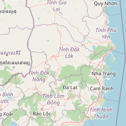
Map view of Tà Đùng National Park

Use this park location map to pinpoint Tà Đùng National Park in Vietnam, understand its exact geographic position, and read its mapped placement within the surrounding landscape more clearly.

Pigeon | © OpenStreetMap contributors

Location context for Tà Đùng National Park

Đắk Nông Province
Park atlas

Explore adjacent protected landscapes and mountain forest reserves, comparing the unique regional geography and conservation zones in Vietnam.

Discover Nearby National Parks and Protected Areas around Tà Đùng National Park in Vietnam's Central Highlands
Continue your park discovery by tracing other national parks and protected areas surrounding Tà Đùng National Park, examining their diverse landscapes, mountain forests, and wetland reserves across Vietnam's Central Highlands region. This comprehensive view helps compare park geography, understand conservation spread, and map the varied protected-area network within this significant ecological corridor.
Watercolor illustration of a landscape with rolling hills, green vegetation, and a body of water
National parkVietnam

Cát Tiên National Park: Vietnam's Premier Protected Lowland Forest and Wetland Atlas

Explore the mapped boundaries and diverse ecosystems of this vital national park.

Cát Tiên National Park represents a significant ecological reserve in southern Vietnam, covering a vast expanse of lowland tropical forest and critical wetland habitats. The park's landscape is shaped by seasonal flooding from the Dong Nai River, creating unique ecosystems like the renowned Bàu Sấu (Crocodile Lake) and supporting diverse flora and fauna. Understanding Cát Tiên National Park's geography, its protected landscape character, and its position within Vietnam offers valuable insights for atlas-based exploration of Southeast Asia's natural heritage.

Area
720 km²
Established
1992
IUCN
II
Relief
Lowland
National parkLâm Đồng Province

Bidoup Nui Ba National Park: Vietnam National Park Atlas and Protected Landscape

Explore mapped boundaries and regional geography of this protected area.

Bidoup Nui Ba National Park is a prominent national park located within the Lâm Đồng Province of Vietnam's Central Highlands. This park serves as a focal point for understanding the regional geography and the distribution of protected lands across Vietnam. Its mapped boundaries define a significant natural landscape, offering users detailed atlas-style context for geographic exploration and protected-area research.

Area
648 km²
Established
2004
IUCN
II
Relief
Mountain
National parkBình Phước Province

Bù Gia Mập National Park: Protected Landscape and Regional Geography in Vietnam

Discover its mapped boundaries and terrain in Bình Phước Province.

Bù Gia Mập National Park is a designated national park in Vietnam, located within the geographical area historically associated with Bình Phước Province. This page focuses on providing a structured understanding of the park's protected land status and its mapped geographic features. Explore the context of this protected landscape, its position within the regional geography, and its role as an element for atlas-based discovery of Vietnam's natural areas.

Area
260.32 km²
Established
2002
IUCN
II
Relief
Upland
National parkNinh Thuận Province

Phước Bình National Park: Protected Area Identity and Geographic Setting in Ninh Thuận

Explore Vietnam's Phước Bình National Park and its mapped terrain.

Phước Bình National Park represents a distinct national park entity situated within Ninh Thuận Province, Vietnam. This destination facilitates an atlas-driven understanding of its protected landscape, emphasizing its geographical placement and mapped boundaries. Explore the core identity of this park as a component of Vietnam's protected areas network and its specific regional landscape context.

Area
198.14 km²
Established
2006
IUCN
II
Relief
Mountain
National parkĐắk Lắk Province

Yok Đôn National Park: Vietnam's Expansive Lowland Forest Protected Landscape and Regional Geography

Mapped boundaries within Đắk Lắk Province, part of a transboundary conservation area.

Yok Đôn National Park is Vietnam's largest lowland forest national park, covering approximately 1,155 square kilometers in Đắk Lắk Province. This protected area is characterized by its rare khộp forest ecosystem and serves as a crucial refuge for large mammals. Situated near the Cambodian border, it forms a key component of one of Southeast Asia's largest continuous protected area networks, offering significant insights into regional protected landscape geography and conservation connectivity.

Area
1,155.45 km²
Established
1986
IUCN
II
Relief
Lowland
Watercolor illustration of a river, trees, and hills in a natural landscape.
National parkĐắk Lắk Province

Chư Yang Sin National Park: Mapped Protected Landscape in Đắk Lắk Province

Explore its protected boundaries and regional geographic context.

Chư Yang Sin National Park stands as a key protected natural area within Vietnam's Central Highlands. This national park, located in the expansive Đắk Lắk Province, provides a rich subject for geographic discovery. Understanding its mapped boundaries and position within the regional landscape offers valuable context for atlas-based exploration of Vietnam's protected lands.

Area
589.47 km²
Established
2002
IUCN
II
Scope
Terrestrial
National parkNinh Thuận Province

Núi Chúa National Park: Protected Landscape and Geographic Atlas Entry

Explore Ninh Thuận Province's national park geography.

Núi Chúa National Park is a key protected area within Vietnam's Ninh Thuận Province, offering vital context for understanding regional geography and mapped natural landscapes. This entry provides the essential geographic details for the park, serving as a foundational element for atlas-based discovery of Vietnam's protected lands. Delve into its mapped boundaries and landscape identity to appreciate its significance.

Area
317.05 km²
Established
2003
IUCN
II
Relief
Mountain
National parkRatanakiri province

O'Yadav National Park: Protected Forest Conservation in Ratanakiri Province

Explore mapped boundaries and regional landscape context.

O'Yadav National Park is a national park located in northeastern Cambodia's Ratanakiri province, designated to protect significant forest ecosystems and serve as a vital link in the nation's biodiversity corridor system. Spanning 105,019 hectares, the park encompasses forested terrain and includes the historically significant Yak Nang temple site. Its conservation efforts contribute to the ecological integrity of the broader Indochinese region, making it a key protected landscape for atlas-based geographic study.

Area
1,050.19 km²
Established
2016
IUCN
II
Scope
Terrestrial

Common questions about visiting, size, designation, and location context for Tà Đùng National Park

Tà Đùng National Park FAQs for park facts, access, geography, and protected area context
Find quick answers about Tà Đùng National Park, including protected-area facts, park geography, trail and visitor context, and how the park fits into its surrounding country and regional landscape.
MoriAtlas Explorer

Continue Your Protected Areas Search Across the Global Atlas

Deepen your exploration by continuing the structured search for national parks and protected areas worldwide. Utilize the comprehensive filtering capabilities to compare different conservation landscapes and refine your understanding of global park geography. Discover more about the distribution and characteristics of protected natural areas.

Global natural geography