Mori Atlas logo
National parkChư Yang Sin National Park

Explore the mapped natural landscapes and protected boundaries of this Vietnamese national park.

Chư Yang Sin National Park: Protected National Park in Đắk Lắk Province

(Vườn quốc gia Chư Yang Sin)

Chư Yang Sin National Park represents a significant protected landscape within Vietnam's Central Highlands. Situated in Đắk Lắk Province, this national park offers a distinct geographic identity for atlas exploration. Users can investigate its mapped boundaries and understand its context within the regional terrain, providing a factual basis for appreciating its protected natural area status.

Vietnam national parksCentral Highlands protected areasMontane forestsGolden jackal habitatIUCN Category IIKrông Bông
Colorful illustration showing a river with large rocks, cliffs with vegetation, and distant mountains under a sky with clouds

Chư Yang Sin National Park

National park

Park overview

Structured park overview, official facts, and landscape profile for Chư Yang Sin National Park

Chư Yang Sin National Park park facts, protected area profile, and essential visitor context
Review the core facts for Chư Yang Sin National Park, including designation, size, terrain, visitor scale, habitats, and operating context in one park-focused overview.

About Chư Yang Sin National Park

Chư Yang Sin National Park occupies a substantial area of protected forest in Vietnam's Central Highlands, a region known for its extensive montane landscapes, coffee plantations, and ethnic minority communities. The park's terrain is characterized by rolling hills and mountain ridges that form part of the larger Annamite Range system, creating diverse microclimates and habitat zones across its elevation gradient. The forest ecosystems within the park represent some of the more intact montane forest remaining in the Central Highlands, though the surrounding landscape has experienced significant agricultural expansion. Protection of these forests is critical for watershed preservation in a region where rivers and groundwater support both agricultural production and local communities. The park's establishment reflected Vietnam's growing commitment to biodiversity conservation in the early 2000s, part of a broader expansion of the national park network during that period.

Quick facts and research context for Chư Yang Sin National Park

Chư Yang Sin National Park is situated in Đắk Lắk Province, the largest province in Vietnam's Central Highlands region, approximately 50 kilometers northwest of Buôn Ma Thuột city. The park covers 589.47 square kilometers across Krông Bông and Lắk counties, incorporating communes at varying elevations. It was officially established as a national park in July 2002 under Decision 92/2002/QĐ-TTg signed by Prime Minister Nguyễn Tấn Dũng. The protected area is governed by the provincial government of Đắk Lắk and represents one of the more significant montane forest protection zones in the Central Highlands.

Park context

Deeper park guide and search-rich context for Chư Yang Sin National Park

Chư Yang Sin National Park history, landscape, wildlife, and travel context
Explore Chư Yang Sin National Park through its history, landscape character, ecosystems, wildlife, conservation priorities, cultural context, and seasonal travel timing in a structured park guide built for atlas discovery and search intent.

Why Chư Yang Sin National Park stands out

Chư Yang Sin National Park is notably the only location in Vietnam with confirmed records of the golden jackal subspecies Canis aureus cruesemanni. This rare subspecies presence represents a significant conservation claim for the park, as these animals are at the extreme eastern edge of their range in this area. The park's montane forest habitats also support populations of larger mammal species and diverse avifauna, though detailed species inventories are limited in available sources. The combination of montane forest protection and the presence of this distinctive canid species makes the park particularly significant within Vietnam's national park system.

River flowing through rocky bed surrounded by dense forest with hills in background
River flowing through rocky terrain in Chư Yang Sin National Park

Chư Yang Sin National Park history and protected-area timeline

Chư Yang Sin National Park was officially established on July 12, 2002, through Decision number 92/2002/QĐ-TTg, signed by then Prime Minister Nguyễn Tấn Dũng. This decision upgraded the area from its previous designation as Chư Yang Sin Nature Reserve to full national park status, recognizing the ecological significance of the area and the need for enhanced protection measures. The elevation to national park status provided additional regulatory frameworks and resources for conservation management. The park's establishment came during a period when Vietnam was expanding its protected area network and strengthening environmental legislation. Prior to national park designation, the area had received some protection as a nature reserve, but the upgrade reflected both the ecological value of the site and the Vietnamese government's priorities for conservation in the Central Highlands region.

Chư Yang Sin National Park landscape and geographic character

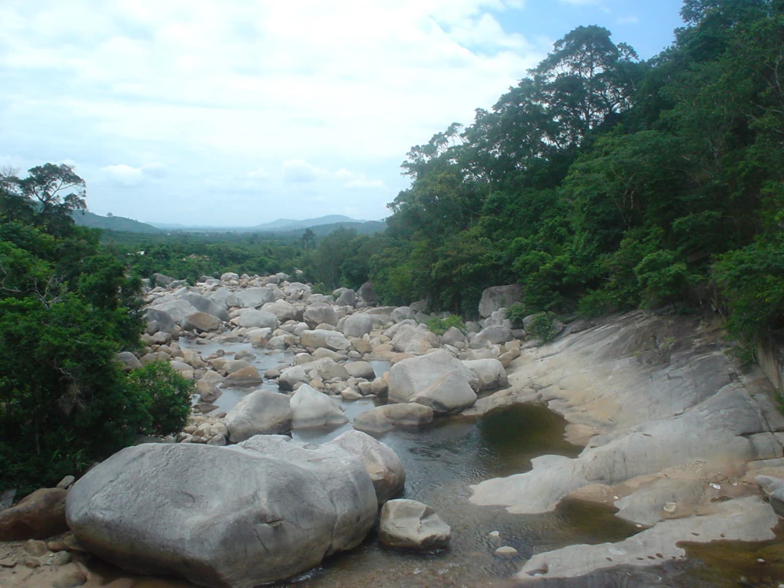
The landscape of Chư Yang Sin National Park is dominated by forested mountain terrain characteristic of the Central Highlands. The terrain features a complex topography of ridges, valleys, and stream courses that create diverse environmental conditions across relatively short distances. Elevations within the park range from approximately 500 meters to over 1,500 meters above sea level, establishing distinct altitudinal zonation in both vegetation and wildlife communities. The underlying geology contributes to the well-drained soils that support robust forest growth, while the region's seasonal rainfall patterns shape the overall ecological character. Streams and small rivers originating in the park contribute to the broader watershed, with the Krông Bông River system having headwaters in the protected area.

Chư Yang Sin National Park ecosystems, habitats, and plant life

The ecological character of Chư Yang Sin National Park centers on its montane forest ecosystems, which represent a transition between lowland tropical forests and higher elevation formations. The forest types present include evergreen broadleaf forests in the lower elevations, transitioning to montane evergreen forests at higher elevations. These forests support a diversity of plant species typical of the Southeast Asian montane environment, though detailed botanical inventories specific to this park are limited in available sources. The montane forest environment creates conditions for species found at the limits of their geographic ranges, with the Central Highlands acting as a biogeographic filter and meeting point for species from different regional faunas.

Chư Yang Sin National Park wildlife and species highlights

The wildlife of Chư Yang Sin National Park includes a notable presence of the golden jackal, with the only confirmed Vietnam records of the subspecies Canis aureus cruesemanni occurring within park boundaries. This represents a significant zoogeographic finding, as the species reaches the eastern edge of its range in this area of Vietnam. The park's forest habitats support populations of larger mammals typical of Central Highlands forests, including various ungulate species and smaller carnivores, though comprehensive species lists are not extensively documented in available sources. The diverse forest structure provides habitat for numerous bird species, and the montane environment attracts both resident and migratory avian species. The presence of the golden jackal underscores the park's importance for conservation, as this canid species requires connected forest habitats and intact prey populations.

Chư Yang Sin National Park conservation status and protection priorities

Chư Yang Sin National Park represents an important protected area within Vietnam's Central Highlands, contributing to national biodiversity conservation targets and ecosystem service provision. The park's montane forests play critical roles in watershed protection, soil retention, and carbon storage, providing benefits that extend beyond the protected boundary to surrounding agricultural lands and communities. The confirmed presence of the golden jackal subspecies elevates the park's conservation significance at both national and international levels, as this represents the only known population in Vietnam. Management of the park focuses on balancing conservation objectives with sustainable use considerations, a common challenge in Vietnam's protected area management framework.

Chư Yang Sin National Park cultural meaning and human context

The Central Highlands region of Vietnam is home to numerous ethnic minority communities whose traditional livelihoods are closely connected to the landscape. The communes within and surrounding Chư Yang Sin National Park include settlements of various ethnic groups whose relationship with the forest resources has evolved over generations. While the park boundaries establish formal conservation status, the management framework considers the interests of local communities and their traditional relationship with the land. The broader Đắk Lắk Province is known for its ethnic diversity and cultural traditions distinct from Vietnam's lowland Vietnamese culture.

Top sights and standout views in Chư Yang Sin National Park

Chư Yang Sin National Park offers protection for some of the Central Highlands' more intact montane forest ecosystems, creating a backdrop for wildlife viewing and nature exploration in a region where natural habitats have been significantly altered by agricultural expansion. The park's significance is concentrated particularly in its role as the only confirmed habitat for golden jackals in Vietnam, a distinction that makes it noteworthy for carnivore conservation and wildlife research. The montane forest environment provides conditions different from Vietnam's more famous lowland parks, offering visitors an opportunity to experience the Central Highlands' distinctive natural character. The park's size of nearly 600 square kilometers creates substantial wilderness character, with core areas of intact forest separated from the more heavily developed agricultural landscape.

Best time to visit Chư Yang Sin National Park

The optimal period for visiting Chư Yang Sin National Park corresponds to the dry season in the Central Highlands, typically running from November through April. During this period, reduced rainfall creates more accessible trail conditions and clearer visibility for landscape appreciation. The dry season coincides with cooler temperatures at higher elevations within the park, making this time more comfortable for hiking and wildlife observation. The wet season from May through October brings heavier rainfall that can affect trail conditions and accessibility, though the forest vegetation is at its lushest during this period. Visitors planning trips should consider that the Central Highlands can experience temperature variations based on elevation, with higher areas within the park being noticeably cooler than lower elevation approach routes.

Park location guide

Geography guide, regional context, and park location map for Chư Yang Sin National Park

Chư Yang Sin National Park park geography, regions, and map view in Vietnam
Understand where Chư Yang Sin National Park sits in Vietnam through a broader geographic reading of the surrounding landscape, nearby location context, and its mapped position within the national park landscape.

How Chư Yang Sin National Park fits into Vietnam

Vietnam, officially the Socialist Republic of Viet Nam, is a unitary communist state in Southeast Asia. It occupies roughly 331,000 square kilometres along the eastern edge of Mainland Southeast Asia, with a population exceeding 102 million. The country is bordered by China to the north, Laos and Cambodia to the west, and has maritime boundaries in the Gulf of Thailand and South China Sea.

Wider geography shaping Chư Yang Sin National Park in Vietnam

Vietnam occupies the eastern edge of Mainland Southeast Asia, stretching along the Gulf of Thailand to the southwest and the South China Sea to the east. The country is bordered by China to the north, and Laos and Cambodia to the west. It has a diverse landscape ranging from the Red River Delta in the north to the Mekong Delta in the south.

Map view of Chư Yang Sin National Park

Use this park location map to pinpoint Chư Yang Sin National Park in Vietnam, understand its exact geographic position, and read its mapped placement within the surrounding landscape more clearly.

Pigeon | © OpenStreetMap contributors

Location context for Chư Yang Sin National Park

Đắk Lắk ProvinceTây Nguyên

Explore diverse montane forest ecosystems and distinct protected area habitats through key imagery, tracing the unique visual character of this Vietnamese park.

Chư Yang Sin National Park Photos: Visualizing Central Highlands Scenery and Montane Forest Landscapes
Browse a curated collection of Chư Yang Sin National Park images to understand its varied landscapes, from lowland evergreen forests to high-altitude montane terrain. These photographs offer critical visual context, revealing the unique habitat structures and scenic elements that define this important Central Highlands protected area.

River flowing through rocky bed surrounded by dense forest with hills in background

Park atlas

Explore adjacent national parks and significant protected areas within Vietnam's Central Highlands region.

Discover More National Parks and Protected Areas Near Chư Yang Sin National Park
After exploring Chư Yang Sin National Park, browse other national parks and protected areas across Vietnam's Central Highlands and its surrounding montane forest ecosystems. This structured geographic overview allows for direct comparison of protected landscapes, highlighting regional biodiversity patterns and conservation priorities within distinct forest types.
National parkLâm Đồng Province

Bidoup Nui Ba National Park: Vietnam National Park Atlas and Protected Landscape

Explore mapped boundaries and regional geography of this protected area.

Bidoup Nui Ba National Park is a prominent national park located within the Lâm Đồng Province of Vietnam's Central Highlands. This park serves as a focal point for understanding the regional geography and the distribution of protected lands across Vietnam. Its mapped boundaries define a significant natural landscape, offering users detailed atlas-style context for geographic exploration and protected-area research.

Area
648 km²
Established
2004
IUCN
II
Relief
Mountain
National parkĐắk Lắk Province

Yok Đôn National Park: Vietnam's Expansive Lowland Forest Protected Landscape and Regional Geography

Mapped boundaries within Đắk Lắk Province, part of a transboundary conservation area.

Yok Đôn National Park is Vietnam's largest lowland forest national park, covering approximately 1,155 square kilometers in Đắk Lắk Province. This protected area is characterized by its rare khộp forest ecosystem and serves as a crucial refuge for large mammals. Situated near the Cambodian border, it forms a key component of one of Southeast Asia's largest continuous protected area networks, offering significant insights into regional protected landscape geography and conservation connectivity.

Area
1,155.45 km²
Established
1986
IUCN
II
Relief
Lowland
National parkNinh Thuận Province

Phước Bình National Park: Protected Area Identity and Geographic Setting in Ninh Thuận

Explore Vietnam's Phước Bình National Park and its mapped terrain.

Phước Bình National Park represents a distinct national park entity situated within Ninh Thuận Province, Vietnam. This destination facilitates an atlas-driven understanding of its protected landscape, emphasizing its geographical placement and mapped boundaries. Explore the core identity of this park as a component of Vietnam's protected areas network and its specific regional landscape context.

Area
198.14 km²
Established
2006
IUCN
II
Relief
Mountain
National parkRatanakiri province

O'Yadav National Park: Protected Forest Conservation in Ratanakiri Province

Explore mapped boundaries and regional landscape context.

O'Yadav National Park is a national park located in northeastern Cambodia's Ratanakiri province, designated to protect significant forest ecosystems and serve as a vital link in the nation's biodiversity corridor system. Spanning 105,019 hectares, the park encompasses forested terrain and includes the historically significant Yak Nang temple site. Its conservation efforts contribute to the ecological integrity of the broader Indochinese region, making it a key protected landscape for atlas-based geographic study.

Area
1,050.19 km²
Established
2016
IUCN
II
Scope
Terrestrial
National parkĐắk Nông Province

Tà Đùng National Park: Protected Landscape and Geographic Atlas Entry

Mapped Boundaries and Regional Terrain Context

Tà Đùng National Park represents a vital protected landscape within Vietnam's Đắk Nông Province, offering rich opportunities for geographic discovery. This entry details the park's identity as a national park, focusing on its mapped boundaries and its contribution to the regional atlas. Explore the fundamental geographic features and protected land context that define Tà Đùng National Park, facilitating a deeper understanding of its place within the broader natural landscape.

Area
209 km²
Established
2018
IUCN
II
Relief
Mountain
National parkNinh Thuận Province

Núi Chúa National Park: Protected Landscape and Geographic Atlas Entry

Explore Ninh Thuận Province's national park geography.

Núi Chúa National Park is a key protected area within Vietnam's Ninh Thuận Province, offering vital context for understanding regional geography and mapped natural landscapes. This entry provides the essential geographic details for the park, serving as a foundational element for atlas-based discovery of Vietnam's protected lands. Delve into its mapped boundaries and landscape identity to appreciate its significance.

Area
317.05 km²
Established
2003
IUCN
II
Relief
Mountain
National parkBình Phước Province

Bù Gia Mập National Park: Protected Landscape and Regional Geography in Vietnam

Discover its mapped boundaries and terrain in Bình Phước Province.

Bù Gia Mập National Park is a designated national park in Vietnam, located within the geographical area historically associated with Bình Phước Province. This page focuses on providing a structured understanding of the park's protected land status and its mapped geographic features. Explore the context of this protected landscape, its position within the regional geography, and its role as an element for atlas-based discovery of Vietnam's natural areas.

Area
260.32 km²
Established
2002
IUCN
II
Relief
Upland
National parkVietnam

Kon Ka Kinh National Park: Vietnam National Park Protected Landscape Atlas

Explore mapped geography and protected area details.

Kon Ka Kinh National Park is a protected natural area situated in Vietnam, designated as a national park to preserve its unique geographic and landscape features. This entry serves as a focused point for atlas-driven discovery, detailing the park's mapped boundaries and its significance within the broader context of Vietnam's regional geography. Understand the protected land's identity and its role in mapping natural landscapes.

Area
417.8 km²
Established
2002
IUCN
II
Relief
Mountain

Common questions about visiting, size, designation, and location context for Chư Yang Sin National Park

Chư Yang Sin National Park FAQs for park facts, access, geography, and protected area context
Find quick answers about Chư Yang Sin National Park, including protected-area facts, park geography, trail and visitor context, and how the park fits into its surrounding country and regional landscape.
MoriAtlas Explorer

Continue Your Protected Areas Search Across the Global Atlas

Deepen your exploration by continuing the structured search for national parks and protected areas worldwide. Utilize the comprehensive filtering capabilities to compare different conservation landscapes and refine your understanding of global park geography. Discover more about the distribution and characteristics of protected natural areas.

Global natural geography