Mori Atlas logo
National parkKon Ka Kinh National Park

Discover the mapped geography and protected area context of Kon Ka Kinh National Park.

Kon Ka Kinh National Park: Vietnam's National Park and Protected Landscape Identity

Kon Ka Kinh National Park stands as a significant protected area within Vietnam, offering a focused point for understanding national park landscapes and their geographic placement. This page details the park's identity as a protected natural area, providing context for its mapped boundaries and its contribution to the regional geography of Vietnam. Explore the specifics of this protected land and its landscape characteristics as part of a structured approach to geographic discovery.

National ParkBiodiversity HotspotASEAN Heritage ParkMontane ForestProtected AreaVietnam

Kon Ka Kinh National Park

National park

Park overview

Structured park overview, official facts, and landscape profile for Kon Ka Kinh National Park

Kon Ka Kinh National Park park facts, protected area profile, and essential visitor context
Review the core facts for Kon Ka Kinh National Park, including designation, size, terrain, visitor scale, habitats, and operating context in one park-focused overview.

About Kon Ka Kinh National Park

Kon Ka Kinh National Park is located in the Central Highlands of Vietnam, a region known for its mountainous terrain, rich biodiversity, and cultural significance. The park sits on the Kon Tum Plateau in northeastern Gia Lai Province, approximately 50 kilometers northeast of Pleiku city, with its administrative center in Ayun Commune of Mang Yang District. The protected area encompasses approximately 418 square kilometers of mountainous landscape characterized by steep valleys, rapid-flowing streams, and dramatic elevation changes.

The park's ecological significance stems from its position at a biogeographic crossroads, where multiple regional floras converge. This has resulted in an extraordinary diversity of plant species, with 687 documented species across 140 families. The forests include evergreen subtropical and tropical forest at lower elevations, transitioning to mixed subtropical pine and broadleaf forest at higher altitudes. The conifer species Fokienia hodginsii dominates approximately 20 square kilometers of the park's forested area, creating distinctive landscape features.

Beyond its ecological value, the park plays a vital role in water resource management. The streams originating from its eastern slopes feed into the Ba River system, while western slopes contribute to Mekong tributaries. These water resources support agricultural irrigation across tens of thousands of hectares in Gia Lai and Kon Tum provinces, making the park economically important for regional food production.

Quick facts and research context for Kon Ka Kinh National Park

Kon Ka Kinh National Park occupies the Kon Tum Plateau in Vietnam's Central Highlands, spanning parts of Mang Yang, K'Bang, and Đắk Đoa districts of Gia Lai Province. The park was originally designated as a special forest area in 1986 and upgraded to national park status in 2002 under Decision 167/2002/QĐ-TTg. Elevations range from 570 to 1,748 meters, with the park serving as a critical watershed protecting the Ba River and Dak Pne River systems. Approximately 80 percent of the park is covered by natural forest, including significant areas of mixed subtropical pine and broadleaf forest dominated by the conifer species Fokienia hodginsii.

Park context

Deeper park guide and search-rich context for Kon Ka Kinh National Park

Kon Ka Kinh National Park history, landscape, wildlife, and travel context
Explore Kon Ka Kinh National Park through its history, landscape character, ecosystems, wildlife, conservation priorities, cultural context, and seasonal travel timing in a structured park guide built for atlas discovery and search intent.

Why Kon Ka Kinh National Park stands out

Kon Ka Kinh National Park is best known for its exceptional biodiversity significance, representing one of Vietnam's most important conservation areas and one of 27 ASEAN Heritage Parks. The park is distinguished by its extraordinary plant diversity, with 687 documented plant species across 140 families, including numerous endemic and endangered species. It serves as a critical watershed protecting the headwaters of major rivers that sustain agricultural production in the Central Highlands. The park also supports significant mammal species including the Indochinese tiger and Yellow-cheeked gibbon, and has been recognized as an Important Bird Area with a dedicated bird sanctuary project.

Kon Ka Kinh National Park history and protected-area timeline

Kon Ka Kinh National Park has undergone significant evolution in its protection status over time. The area was first designated as a special forest in 1986 under Decision 194/CT dated August 9, 1986, issued by the Chairman of Vietnam's Council of Ministers. At that time, the protected area covered 280 square kilometers with the primary purpose of preserving subtropical forest in the high mountains, with particular emphasis on gymnosperm species.

In 1999, the Forest Investigation and Planning Institute of Vietnam, in partnership with BirdLife International, developed the Kon Ka Kinh Bird Sanctuary Project. This initiative led to expanded protection of the area and was approved in the same year by the Ministry of Agriculture and Rural Development and the Gia Lai People's Committee, increasing the protected area to 417.8 square kilometers. The national park was officially established in 2002 by Decision 167/2002/QĐ-TTg on November 25, 2002, signed by Prime Minister Phan Văn Khải. This designation elevated the area to IUCN Category II protected status and positioned it among Vietnam's priority conservation areas.

Kon Ka Kinh National Park landscape and geographic character

Kon Ka Kinh National Park features a dramatic mountainous landscape characterized by significant elevation variation across relatively short distances. The terrain ranges from 570 meters in the Ba River valley to 1,748 meters at Kon Ka Kinh peak, creating diverse microclimates and habitat zones. The park's topography is sloping and rugged, with numerous short, fast-flowing streams that have carved valleys and created multiple waterfalls throughout the area.

The Ba River, a prominent watercourse originating in the park's eastern portions, runs northward before turning northwest-southeast and ultimately emptying into the South China Sea near Tuy Hòa city. The park's western slopes drain into tributaries of the Mekong River system. This dual watershed position gives the park significant importance in regional hydrology. The landscape supports approximately 33,565 hectares of natural forest, representing about 80 percent of the total park area, with distinctive vegetation zones influenced by altitude and slope orientation.

Kon Ka Kinh National Park ecosystems, habitats, and plant life

The ecological character of Kon Ka Kinh National Park is defined by its remarkable plant diversity resulting from the convergence of multiple biogeographic regions. The park contains flora typical of northern and central Vietnam, including families such as Fabaceae, Euphorbiaceae, Magnoliaceae, Moraceae, Annonaceae, Lauraceae, and Fagaceae, which thrive in wet tropical rainforest conditions at lower elevations. These areas feature high tree density with non-typical dominant species.

The park also hosts species with origins in Yunnan-Guizhou and Himalayan foothills, including important gymnosperms like Podocarpus imbricatus, Dacrydium pierrei, Nageia wallichiana, and Fokienia hodginsii. Species with Malaysian-Indonesian origins include Anogeissus acuminata and various Dipterocarpaceae species, while India-Myanmar influences appear in families like Combretaceae and Lythraceae. This botanical mosaic supports 687 plant species across 459 genera and 140 families, including 11 documented endemic species and 24 species listed as precious or rare in Vietnam's Endangered Red Book and the IUCN Red List.

Kon Ka Kinh National Park wildlife and species highlights

Kon Ka Kinh National Park supports a diverse animal community, with surveys documenting 428 animal species including 223 species of land vertebrates spanning 34 orders and 74 families, and 205 invertebrate species. The mammal population includes notable species such as the Indochinese tiger and Yellow-cheeked gibbon, both representing significant conservation priorities. The park's birdLife International designation reflects its importance for avifauna, with the bird sanctuary project established in partnership with international conservation organizations.

The invertebrate diversity includes at least 10 families of Lepidoptera, representing butterflies and moths. This invertebrate community contributes to the park's ecological functioning through pollination, decomposition, and as a food source for vertebrate predators. The combination of diverse forest habitats, from valley bottoms to montane zones, supports this variety of animal life and creates opportunities for wildlife observation and ecological study.

Kon Ka Kinh National Park conservation status and protection priorities

Kon Ka Kinh National Park holds significant conservation importance at both national and regional levels. The park is designated as one of Vietnam's priority zones for biodiversity protection and is recognized as one of 27 ASEAN Heritage Parks, a regional network of protected areas of outstanding conservation significance. This dual designation reflects the park's exceptional ecological value and its importance in maintaining regional biodiversity patterns.

The protected area serves critical ecological functions beyond species preservation, including watershed protection for the Ba River and Dak Pne River systems that support agricultural production across extensive areas of the Central Highlands. The park's forest cover also contributes to carbon storage and climate regulation. Conservation challenges include managing the balance between protection and sustainable use, addressing threats from habitat fragmentation, and ensuring effective enforcement within the complex terrain. The presence of 24 species listed in Vietnam's Red Book and the IUCN Red List underscores the urgency of continued conservation efforts.

Kon Ka Kinh National Park cultural meaning and human context

Kon Ka Kinh National Park is situated in the Central Highlands of Vietnam, a region home to numerous indigenous ethnic communities. The park spans three districts of Gia Lai Province: Mang Yang, K'Bang, and Đắk Đoa. While the Wikipedia source does not provide extensive detail on cultural aspects, the region's ethnic minority communities have traditionally lived in close connection with the forest ecosystems that the park now protects. The area's proximity to the Yaly Hydroelectricity Plant to the west also reflects broader development dynamics in the Central Highlands region.

Top sights and standout views in Kon Ka Kinh National Park

Kon Ka Kinh National Park stands out as one of Vietnam's most botanically significant protected areas, with 687 plant species representing an unusual convergence of multiple biogeographic regions. The park's designation as an ASEAN Heritage Park reflects its regional importance. Its role as a critical watershed, protecting headwaters that sustain agricultural production across two provinces, demonstrates its environmental and economic significance. The presence of endemic species including Pinus dalatensis and the remarkable Fokienia hodginsii forests distinguishes this park from other Central Highland protected areas.

Best time to visit Kon Ka Kinh National Park

The best time to visit Kon Ka Kinh National Park is during the dry season, typically from November to April, when rainfall is reduced and trail conditions are more favorable for exploration. The park's elevation range creates varied microclimimes, with montane areas potentially experiencing cooler temperatures than valley floors. Visitors interested in wildlife viewing may find the dry season more conducive as animals congregate around remaining water sources. The period from March to May offers warm temperatures before the monsoon rains arrive, though the landscape remains green from the previous wet season.
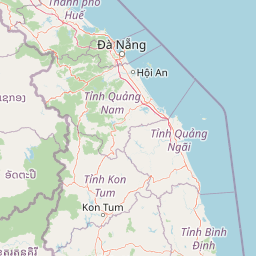

Park location guide

Geography guide, regional context, and park location map for Kon Ka Kinh National Park

Kon Ka Kinh National Park park geography, regions, and map view in Vietnam
Understand where Kon Ka Kinh National Park sits in Vietnam through a broader geographic reading of the surrounding landscape, nearby location context, and its mapped position within the national park landscape.

How Kon Ka Kinh National Park fits into Vietnam

Vietnam, officially the Socialist Republic of Viet Nam, is a unitary communist state in Southeast Asia. It occupies roughly 331,000 square kilometres along the eastern edge of Mainland Southeast Asia, with a population exceeding 102 million. The country is bordered by China to the north, Laos and Cambodia to the west, and has maritime boundaries in the Gulf of Thailand and South China Sea.

Wider geography shaping Kon Ka Kinh National Park in Vietnam

Vietnam occupies the eastern edge of Mainland Southeast Asia, stretching along the Gulf of Thailand to the southwest and the South China Sea to the east. The country is bordered by China to the north, and Laos and Cambodia to the west. It has a diverse landscape ranging from the Red River Delta in the north to the Mekong Delta in the south.

Map view of Kon Ka Kinh National Park

Use this park location map to pinpoint Kon Ka Kinh National Park in Vietnam, understand its exact geographic position, and read its mapped placement within the surrounding landscape more clearly.

Pigeon | © OpenStreetMap contributors

Location context for Kon Ka Kinh National Park

Gia Lai ProvinceKon Tum Province
Park atlas

Browse the Surrounding Montane Forests and Watershed Protected Areas of the Kon Tum Plateau

Discover Other National Parks Near Kon Ka Kinh National Park, Vietnam's Central Highlands Protected Areas
Explore a curated list of national parks and protected areas geographically related to Kon Ka Kinh National Park, tracing the distinct montane forests and watershed landscapes of Vietnam's Central Highlands. Continue your atlas exploration by comparing ecological features, conservation priorities, and regional protected area networks across the Kon Tum Plateau.
National parkKon Tum Province

Chư Mom Ray National Park: A Mapped Protected Landscape in Kon Tum Province, Vietnam

Explore National Park Geography and Protected Boundaries

Chư Mom Ray National Park is a vital national park located in Vietnam's Kon Tum Province. This page offers an atlas-style exploration of its protected landscape, detailing its geographic setting and mapped boundaries. Discover how Chư Mom Ray National Park fits into the regional geography of Vietnam and understand its significance as a distinct conservation area within the broader landscape.

Area
566.21 km²
Established
2002
IUCN
II
Access
Access unknown
National parkRatanakiri province

O'Yadav National Park: Protected Forest Conservation in Ratanakiri Province

Explore mapped boundaries and regional landscape context.

O'Yadav National Park is a national park located in northeastern Cambodia's Ratanakiri province, designated to protect significant forest ecosystems and serve as a vital link in the nation's biodiversity corridor system. Spanning 105,019 hectares, the park encompasses forested terrain and includes the historically significant Yak Nang temple site. Its conservation efforts contribute to the ecological integrity of the broader Indochinese region, making it a key protected landscape for atlas-based geographic study.

Area
1,050.19 km²
Established
2016
IUCN
II
Scope
Terrestrial
National parkRatanakiri province

Virachey National Park: Cambodia's Vast Highland Protected Landscape in Ratanakiri

Explore its remote montane forest ecosystems and diverse terrain.

Virachey National Park, Cambodia's largest national park, offers a profound glimpse into one of mainland Southeast Asia's last great wildernesses. Spanning remote highland terrain in Ratanakiri province, it features dramatic elevation changes from 400 to 1,500 meters, supporting diverse ecosystems including dense lowland forests, unique montane cloud forests, and upland savannahs. Its recognition as an ASEAN Heritage Park underscores its critical regional conservation value, making it a significant destination for understanding protected landscapes and their geographic context.

Area
3,380.57 km²
Established
1993
IUCN
II
Relief
Mountain
Watercolor illustration of a river, trees, and hills in a natural landscape.
National parkĐắk Lắk Province

Chư Yang Sin National Park: Mapped Protected Landscape in Đắk Lắk Province

Explore its protected boundaries and regional geographic context.

Chư Yang Sin National Park stands as a key protected natural area within Vietnam's Central Highlands. This national park, located in the expansive Đắk Lắk Province, provides a rich subject for geographic discovery. Understanding its mapped boundaries and position within the regional landscape offers valuable context for atlas-based exploration of Vietnam's protected lands.

Area
589.47 km²
Established
2002
IUCN
II
Scope
Terrestrial
National parkRatanakiri province

Veun Sai, Siem Pang National Park: Northeastern Cambodia's Protected Lowland Forest Landscape

Mapped Boundaries and Primate Conservation Habitat

Veun Sai, Siem Pang National Park in Cambodia's Ratanakiri province is a vital protected area featuring expansive lowland evergreen and semi-evergreen forests. Its designation as a national park underscores its role in safeguarding critical habitat for diverse primate populations, notably the endangered Northern buffed-cheeked gibbon. The park's geography, characterized by gentle terrain and extensive forest cover, makes it a significant component of the region's biodiversity corridor and a key site for understanding Cambodia's natural landscapes.

Area
574.69 km²
Established
2016
IUCN
II
Relief
Lowland
National parkĐắk Lắk Province

Yok Đôn National Park: Vietnam's Expansive Lowland Forest Protected Landscape and Regional Geography

Mapped boundaries within Đắk Lắk Province, part of a transboundary conservation area.

Yok Đôn National Park is Vietnam's largest lowland forest national park, covering approximately 1,155 square kilometers in Đắk Lắk Province. This protected area is characterized by its rare khộp forest ecosystem and serves as a crucial refuge for large mammals. Situated near the Cambodian border, it forms a key component of one of Southeast Asia's largest continuous protected area networks, offering significant insights into regional protected landscape geography and conservation connectivity.

Area
1,155.45 km²
Established
1986
IUCN
II
Relief
Lowland
National parkLâm Đồng Province

Bidoup Nui Ba National Park: Vietnam National Park Atlas and Protected Landscape

Explore mapped boundaries and regional geography of this protected area.

Bidoup Nui Ba National Park is a prominent national park located within the Lâm Đồng Province of Vietnam's Central Highlands. This park serves as a focal point for understanding the regional geography and the distribution of protected lands across Vietnam. Its mapped boundaries define a significant natural landscape, offering users detailed atlas-style context for geographic exploration and protected-area research.

Area
648 km²
Established
2004
IUCN
II
Relief
Mountain
National parkVietnam

Bach Ma National Park: Protected Area and Mountain Landscape in Vietnam

Explore the biodiversity and unique geography of this vital national park.

Bach Ma National Park in Vietnam is a protected area defined by its steep, granite-rich mountainous terrain within the Annamite Range. The park’s location at a significant biogeographical crossroads contributes to its exceptional biodiversity, particularly its documented birdlife and varied forest ecosystems. Understanding Bach Ma National Park through its mapped landscape provides critical insight into Vietnam's natural heritage and the ecological dynamics shaped by its unique regional geography.

Area
220 km²
Established
1986
IUCN
II
Relief
Mountain

Common questions about visiting, size, designation, and location context for Kon Ka Kinh National Park

Kon Ka Kinh National Park FAQs for park facts, access, geography, and protected area context
Find quick answers about Kon Ka Kinh National Park, including protected-area facts, park geography, trail and visitor context, and how the park fits into its surrounding country and regional landscape.
MoriAtlas Explorer

Continue Your Protected Areas Search Across the Global Atlas

Deepen your exploration by continuing the structured search for national parks and protected areas worldwide. Utilize the comprehensive filtering capabilities to compare different conservation landscapes and refine your understanding of global park geography. Discover more about the distribution and characteristics of protected natural areas.

Global natural geography