Mori Atlas logo
National parkBosencheve National Park

Discover the mapped boundaries and regional setting of this protected area in the State of Mexico.

Bosencheve National Park: National Park Protected Landscape and Geographic Context

Bosencheve National Park is a designated national park located in the State of Mexico, offering a distinct protected landscape for atlas-based exploration. This page provides essential geographic context, detailing the park's mapped boundaries and its place within the regional terrain of Mexico. Understand its protected area identity and how it contributes to the broader natural geography of the State of Mexico.

Mountain parksLake reservesForest protectionTrans-Mexican volcanic beltIUCN Category IICentral Mexico

Bosencheve National Park

National park

Park overview

Structured park overview, official facts, and landscape profile for Bosencheve National Park

Bosencheve National Park park facts, protected area profile, and essential visitor context

Review the core facts for Bosencheve National Park, including designation, size, terrain, visitor scale, habitats, and operating context in one park-focused overview.

About Bosencheve National Park

Bosencheve National Park occupies a mountainous stretch of central Mexico where the states of Michoacán and State of Mexico meet. The protected area encompasses approximately 146 square kilometers of terrain characterized by volcanic origins, forest cover, and the presence of two natural lakes that give the park its distinctive character. Established in 1940, it ranks among Mexico's older national parks and serves as an important conservation area within the trans-Mexican volcanic belt, a mountain chain that crosses central Mexico and supports diverse ecological communities. The park's landscape includes forested slopes, ridgelines, and the lake basins that collect water from the surrounding highlands. Visitor facilities include hiking trails that allow exploration of the park's varied terrain, and the proximity to Mexico City makes the park accessible for day trips and weekend excursions from the capital.

Quick facts and research context for Bosencheve National Park

Bosencheve National Park occupies 14,600 hectares along the boundary between Michoacán and State of Mexico in central Mexico. The park was established in 1940, making it one of the earliest protected areas in Mexico's national park system. It is classified under IUCN Category II as a national park and is managed by Mexico's National Commission of Natural Protected Areas. The park contains two natural lakes, Lago Verde and Lago Seca, and features a network of hiking trails that traverse its mountainous terrain. The area sits within the trans-Mexican volcanic belt, a mountainous region known for its ecological diversity and geological significance.

Protection and recognition

Analyzing documented terrestrial status, protection frameworks, and official conservation categories.

Bosencheve National Park Protection Status and Terrestrial Conservation Designations

Bosencheve National Park features a terrestrial protection framework established to secure its regional geography and natural forest habitats. Detailed atlas records compile the documented designation history, management scope, and verified ecological boundaries to assist global researchers and conservation explorers.

Protection details

Protection scope
Terrestrial
Park context

Deeper park guide and search-rich context for Bosencheve National Park

Bosencheve National Park history, landscape, wildlife, and travel context

Explore Bosencheve National Park through its history, landscape character, ecosystems, wildlife, conservation priorities, cultural context, and seasonal travel timing in a structured park guide built for atlas discovery and search intent.

Why Bosencheve National Park stands out

Bosencheve National Park is best known for its pair of scenic mountain lakes set within a forested volcanic landscape. Lago Verde and Lago Seca anchor the park's identity, offering visitors distinctive water features in an otherwise heavily forested highland environment. The park's established status since 1940 also gives it historical significance within Mexico's conservation history, and its location in the trans-Mexican volcanic belt places it within one of the country's most ecologically important mountain regions.

Bosencheve National Park history and protected-area timeline

Bosencheve National Park was established in 1940, placing its creation during a period when Mexico was developing its earliest national park system. The designation of this mountainous area as a protected area reflected growing recognition of the importance of preserving scenic landscapes and natural environments in central Mexico. The park's establishment created a protected zone around its two significant lakes and the surrounding forest, setting aside the area for conservation and public enjoyment. Over the decades, the park has been managed under Mexico's system of protected natural areas, currently overseen by the National Commission of Natural Protected Areas.

Bosencheve National Park landscape and geographic character

The landscape of Bosencheve National Park is defined by its mountainous setting within the trans-Mexican volcanic belt. The terrain features volcanic ridges and forested slopes that rise from the lake basins at the park's core. Two lakes, Lago Verde and Lago Seca, serve as prominent landscape features, their waters reflecting the surrounding forest and mountain backdrop. The park's elevation and volcanic geology create a landscape of moderate to steep terrain, with drainage patterns feeding the lake systems. Forest vegetation covers much of the higher ground, while the lake margins and lower slopes support different plant communities adapted to the moist highland conditions.

Bosencheve National Park ecosystems, habitats, and plant life

Bosencheve National Park protects a segment of central Mexico's highland forest ecosystems within the trans-Mexican volcanic belt. The park's elevation range and moisture patterns support forest communities that differ from the lower-elevation tropical environments found in surrounding lowlands. The presence of the two lakes creates aquatic and wetland habitats that add ecological diversity to the protected area. As a protected area spanning the boundary between two states, Bosencheve also functions as a conservation corridor supporting wildlife movement through the mountainous landscape. The forest and lake habitats together create a relatively intact natural environment that supports resident species and provides ecological functions related to watershed protection and biodiversity maintenance.

Bosencheve National Park wildlife and species highlights

The forests and lakes of Bosencheve National Park provide habitat for various species adapted to central Mexico's highland environments. The lake systems support aquatic wildlife and attract bird species that use the water bodies for feeding and nesting. Forest areas within the park shelter terrestrial wildlife including various bird species, small mammals, and other fauna characteristic of the trans-Mexican volcanic belt region. The protected status of the area helps maintain wildlife populations in a region where habitat conversion has affected many natural areas.

Bosencheve National Park conservation status and protection priorities

Bosencheve National Park represents an established conservation designation within Mexico's protected areas system. Its IUCN Category II classification as a national park reflects its purpose of protecting natural landscapes and supporting public enjoyment of nature. The park's location in the trans-Mexican volcanic belt places it within an ecologically significant region that supports diverse habitats. By protecting forest areas, lake systems, and the watershed functions they provide, the park contributes to maintaining ecological integrity in central Mexico. Management by the National Commission of Natural Protected Areas ensures ongoing protection of the park's natural values.

Top sights and standout views in Bosencheve National Park

The defining highlights of Bosencheve National Park are its two mountain lakes, Lago Verde and Lago Seca, set within a forested volcanic landscape. The park's established history since 1940 gives it significance as one of Mexico's older national parks. Its location in the trans-Mexican volcanic belt provides geological and ecological context, while its relative accessibility from Mexico City makes it a practical destination for nature visitors to central Mexico. Hiking trails offer exploration of the park's terrain, allowing visitors to experience the forest environment and lakeside scenery.

Best time to visit Bosencheve National Park

The best time to visit Bosencheve National Park is during the drier months from late autumn through early spring, when trail conditions are generally more favorable and visitor access is easier. The central Mexican highland climate means that the park experiences a wet season during summer months, when trail conditions may be more challenging and rainfall more frequent. The cooler dry season months often provide more comfortable conditions for hiking and outdoor exploration. Visitors planning trips should consider that the park's mountain setting means temperatures can be cooler than in the Mexico City area, especially at higher elevations within the protected area.
Monthly climate preview

Long-term representative temperature ranges and monthly precipitation distributions

Bosencheve National Park Climate Normals and Annual Weather Patterns

Representative coordinates record measured average temperatures ranging from 11.31 degrees Celsius to 18.13 degrees Celsius alongside distinct monthly precipitation variations from 0.17 to 5.49 millimeters per day. Examining the complete twelve-month climatology profile reveals deeper multi-year temperature trends and precipitation records for this protected landscape.
Annual mean15 °C
11 °C18 °C
Jan11°
Feb13°
Mar15°
Apr17°
May18°
Jun17°
Jul16°
Aug16°
Sep15°
Oct14°
Nov13°
Dec12°
Warmest month
May

18.1 °C

Coolest month
January

11.3 °C

Wettest month
July

5.5 mm/day

Driest month
December

0.2 mm/day

Park location guide

Geography guide, regional context, and park location map for Bosencheve National Park

Bosencheve National Park park geography, regions, and map view in Mexico

Understand where Bosencheve National Park sits in Mexico through a broader geographic reading of the surrounding landscape, nearby location context, and its mapped position within the national park landscape.

How Bosencheve National Park fits into Mexico

Mexico, officially the United Mexican States, is a country in North America spanning the Sierra Madre mountain ranges, coastal plains, and tropical regions. It borders the United States to the north, Guatemala and Belize to the southeast, and has coastlines along the Pacific Ocean, Gulf of Mexico, and Caribbean Sea. With a population exceeding 130 million, Mexico is home to one of the world's most significant concentrations of Indigenous languages alongside Spanish.

Wider geography shaping Bosencheve National Park in Mexico

Mexico occupies a land area of 1,972,550 km2, making it the thirteenth-largest country in the world. The terrain is highly diverse, featuring the Sierra Madre Occidental and Sierra Madre Oriental mountain ranges, the Mexican Plateau, coastal lowlands along the Pacific and Gulf/Caribbean margins, and the Yucatan Peninsula. The country spans multiple climate zones from desert in the north to tropical rainforest in the south.

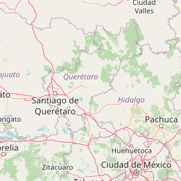
Map view of Bosencheve National Park

Use this park location map to pinpoint Bosencheve National Park in Mexico, understand its exact geographic position, and read its mapped placement within the surrounding landscape more clearly.

Pigeon | © OpenStreetMap contributors

Location context for Bosencheve National Park

MichoacánState of Mexico
Park atlas

Explore the regional geography of protected landscapes, forest reserves, and mountain parks in the Trans-Mexican Volcanic Belt surrounding Bosencheve.

Discover Other National Parks and Protected Areas Near Bosencheve National Park

After exploring Bosencheve National Park's mountain lakes and volcanic terrain, browse other national parks and protected areas across Central Mexico's highland ecosystems. Compare their unique conservation landscapes and geographic features within the Trans-Mexican Volcanic Belt, understanding regional park distribution and ecological connections.
Protected areaState of Mexico
About 24 km away#1 closest

South

Zona Protectora Forestal los terrenos constitutivos de las cuencas de los ríos Valle de Bravo, Malacatepec, Tilostoc y Temascaltepec

Highland watershed and mountain forest reserve in the State of Mexico

Examine the expansive forested catchment area defined by the Trans-Mexican Volcanic Belt. This protected landscape is fundamental for regional hydrology and provides critical winter habitat within the mountainous geography of the State of Mexico.

Area
1,402.34 km²
Established
1941
IUCN
VI
Relief
Mountain
National parkMichoacán
About 47 km away#2 closest

Northwest

Insurgente José María Morelos y Pavón National Park: Mapped Protected Landscape in Michoacán

Discover its geographic context and protected area boundaries.

Explore Insurgente José María Morelos y Pavón National Park, a designated national park in Michoacán, Mexico. This page provides detailed insights into its protected status, mapped geographic features, and its role as a significant natural landscape within the regional atlas. Understand the park's protected boundaries and its contribution to the geographic understanding of Michoacán.

Area
71.92 km²
Established
1939
IUCN
II
Relief
Mountain
Wildlife reserveEstado de México
About 50 km away#3 closest

Southeast

Área de protección de flora y fauna Nevado de Toluca: Geography and Protected Landscapes

High-altitude volcanic massif and hydrological protected area

Situated in the State of Mexico, this wildlife reserve preserves the dramatic volcanic slopes of the Nevado de Toluca. The protected area features significant elevation gradients, crater lakes, and transition forests that anchor the regional watershed and provide a habitat for a wide array of plant and animal species.

Area
467.84 km²
Established
1936
IUCN
II
Relief
Mountain
National parkMexico State
About 50 km away#4 closest

Southeast

Nevado de Toluca National Park: Protected Landscape Atlas and Geographic Context

Explore mapped boundaries and regional terrain within Mexico State.

Nevado de Toluca National Park serves as a key protected landscape for understanding the natural geography of Mexico State. This destination facilitates detailed exploration of its mapped territory, protected area identity, and the surrounding regional context. Discover how this national park fits into the larger geographic atlas through its distinct terrain and documented boundaries, offering a factual foundation for landscape research.

Area
510 km²
Established
1936
IUCN
VI
Relief
Mountain
Protected landscapeEstado de México
About 68 km away#5 closest

East

Ciénegas del Lerma: Protected Highland Wetland Landscape in the State of Mexico

Mapping the upper Lerma River basin and remnant marsh ecosystems.

Ciénegas del Lerma serves as a significant protected landscape in central Mexico, encompassing three main lakes and extensive marshland corridors. This atlas entry details the site's hydrological structure, encompassing open-water zones and alluvial soils that support diverse aquatic vegetation and endemic species within a human-influenced highland setting.

Area
30.23 km²
Established
2002
IUCN
VI
Relief
Upland
National parkMexico
About 81 km away#6 closest

East

La Marquesa National Park: Atlas of Protected Highland Forests in Mexico's Sierra de las Cruces

Explore its mapped boundaries and regional geographic context.

La Marquesa National Park represents a critical protected natural zone in Mexico's central highlands, specifically within the Sierra de las Cruces mountain range. Its landscape is defined by rugged volcanic terrain, featuring steep slopes and deep ravines densely covered by pine and oak woodlands. Designated as an early national park, it plays a crucial role in watershed protection for the surrounding region, preserving unique highland forest ecosystems and their associated biodiversity. This park offers a tangible example of protected landscape within Mexico's atlas, highlighting its ecological significance and geographic positioning.

IUCN
II
National parkMichoacán
About 84 km away#7 closest

West

Cerro de Garnica National Park: Its Geography and Protected Landscape Identity

Explore mapped boundaries within Michoacán's natural terrain.

Cerro de Garnica National Park serves as a distinct protected area contributing to the geographic understanding of Michoacán. This page offers a focused view on its mapped boundaries and natural landscape characteristics, providing essential context for atlas exploration. Discover the park's specific identity as a national park and its place within the regional geography, highlighting its value for structured discovery.

Area
19.36 km²
Established
1936
IUCN
II
Relief
Mountain
National parkMexico City
About 85 km away#8 closest

East

Desierto de los Leones National Park: Protected National Park and its Geographic Setting

Explore mapped boundaries and regional landscape context near Mexico City.

Delve into the specifics of Desierto de los Leones National Park, a designated national park recognized for its protected landscape. This MoriAtlas entry focuses on its geographic presence within the Mexico City region, providing clear insights into its mapped boundaries and the surrounding natural terrain. Understand the park's importance as a conservation area and its contribution to the regional geography through dedicated atlas data.

Area
18.67 km²
Established
1917
IUCN
II
Visitors
205K annual

Common questions about visiting, size, designation, and location context for Bosencheve National Park

Bosencheve National Park FAQs for park facts, access, geography, and protected area context

Find quick answers about Bosencheve National Park, including protected-area facts, park geography, trail and visitor context, and how the park fits into its surrounding country and regional landscape.
MoriAtlas Explorer

Continue Your Protected Areas Search Across the Global Atlas

Deepen your exploration by continuing the structured search for national parks and protected areas worldwide. Utilize the comprehensive filtering capabilities to compare different conservation landscapes and refine your understanding of global park geography. Discover more about the distribution and characteristics of protected natural areas.

Global natural geography