
Lakes
Park geography
Analyzing the regional landscape, coastal terrain, and documented environmental features.
Structured Geographic Profile and Mapped Boundaries of Bruce Peninsula National Park
Examine the technical geographic footprint of Bruce Peninsula National Park in Ontario, Canada. This profile details the 154 square kilometer recorded boundary, coastal cliff systems, temperate forest coverage, and diverse karst landscapes found within the region.
Related tags
Niagara EscarpmentGeorgian BayDolomite CliffsKarst FormationsDark Sky Preserve
Dramatic Niagara Escarpment cliffs meeting the crystal waters of Georgian Bay
Bruce Peninsula National Park
Bruce Peninsula National Park occupies a striking position on the Bruce Peninsula in northern Ontario, where the ancient limestone ramparts of the Niagara Escarpment plunge directly into the clear, deep waters of Georgian Bay. Established in 1987 to protect the exceptional rock formations and shoreline of this region, the park encompasses approximately 154 square kilometres of rugged landscape and forms the core of UNESCO's Niagara Escarpment World Biosphere Reserve. The park is renowned for its dramatic cliff formations, karst caves, cobblestone beaches, and the famous Grotto, a sea cave that has become one of the most photographed locations in Ontario. Visitors experience a rare combination of boreal forest, alpine-like cliffs, and Great Lakes coastal ecosystems within a relatively compact area.
- Location
- Canada
- Park type
- National park
- Established
- 1987
- Area
- 154 km²
Location overview
Coastal Protected Landscapes within Ontario, Canada
Bruce Peninsula National Park: Regional Geography and Coastal Setting
Bruce Peninsula National Park occupies a key regional position in Ontario, Canada. Official records verify its coastal status alongside provincial and national administrative alignments.
- Countries
- Canada
- Regions
- Ontario
- Primary location
- Ontario
- Geographic setting
- Coastal
Boundary and coordinates
Mapping the 154 square kilometer conservation footprint and spatial span
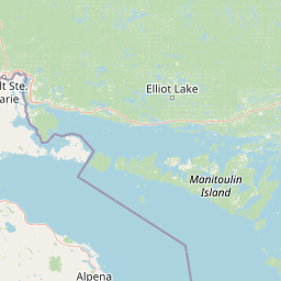
Geographic Boundary Map for Bruce Peninsula National Park
Detailed boundary mapping traces the geographic limits of the protected area to provide clear spatial context. Geographic datasets detail the 154 square kilometer area alongside calculated coordinates, center points, and regional spans.
- Boundary area
- 143.1 km²
- Boundary perimeter
- 214.9 km
- Northernmost point
- 45.2544° N
- Southernmost point
- 45.0748° N
- Easternmost point
- 81.3397° W
- Westernmost point
- 81.6309° W
- Geographic centre
- 45.1941° N, 81.4911° W
- North–south span
- 20 km
- East–west span
- 22.9 km
Terrain and natural features
Stored highland terrain classifications and recorded natural features
Bruce Peninsula National Park Terrain and Named Natural Features
Highland terrain classifications define the protected landscape across Bruce Peninsula National Park. Linked feature cards supply names, types, and spatial relationships for recorded natural features within the park boundaries.
Selected named natural features
Cliffs
Bruce Peninsula
Lakes
Marley Lake
Lakes
Lower Andrew Lake
Peninsulas
Bruce Peninsula
Lakes
Clear Lake
Environmental setting
Temperate forest coverage, highland relief, and major water features
Bruce Peninsula National Park Environmental Setting and Physical Classifications
Stored landscape features, temperate habitat types, and seasonal classifications form complementary ways to read the physical setting of Bruce Peninsula National Park. Recorded environmental categories connect directly to relevant atlas destinations across the protected geography.
- Relief
- Highland
- Climate
- Temperate
- Water
- Major water bodies
- Forest cover
- Mostly forested
- Seasonality
- Seasonal
Landscape features
Plateau · Cliffs · Forest · Wetland · Lakes · Coast · Beach · Cave · Karst
Habitat types
Temperate broadleaf forest · Temperate coniferous forest · Wetland · Grassland · Coastal habitat · Karst habitat
Park atlas
Explore surrounding national parks, compare regional protected areas, and trace the Niagara Escarpment's unique geographic spread.
Discover Related National Parks and Protected Areas near Bruce Peninsula National Park
Continue exploration from Bruce Peninsula National Park by browsing other national parks and protected areas, mapping their geographic spread across the Niagara Escarpment and Great Lakes region. Explore distinct protected landscapes, understand their regional context, and discover adjacent conservation areas through this focused atlas view for comprehensive geographic comparison.
Marine protected areaMichigan
66 km away#1 closest
West

Thunder Bay National Marine Sanctuary: Geography and Protected Maritime Landscape Context
Mapping underwater heritage in the Michigan Great Lakes region
Spanning 4,300 square miles of Lake Huron, Thunder Bay National Marine Sanctuary preserves a significant collection of shipwrecks within a glacially shaped freshwater terrain. This marine protected area offers a look at submerged geography ranging from shallow coastal bays to deep lake basins. It serves as a vital anchor for understanding maritime history and freshwater ecosystem stability across the Michigan shoreline.
- Area
- 11,000 km²
- Established
- 2000
- Relief
- Lowland
- Climate
- Temperate
National parkOntario
96 km away#2 closest
East

Georgian Bay Islands National Park: Ontario National Park Protected Landscape Atlas
Explore mapped boundaries and regional geographic context.
Gain a comprehensive understanding of Georgian Bay Islands National Park as a distinct protected area within Ontario. This entry provides detailed geographic context, focusing on the park's mapped landscape, its protected status as a national park, and its position within the regional geography of Canada. It is designed for users seeking structured information about protected lands and their atlas-level significance.
- Area
- 13.5 km²
- Established
- 1929
- IUCN
- II
- Visitors
- 27.5K annual
Marine protected areaMichigan
About 130 km away#3 closest
West
Thunder Bay National Marine Sanctuary and Underwater Preserve: Geography and Protected Area Atlas
Maritime heritage sites and glacial freshwater geography in Lake Huron, Michigan.
Situated along the rugged northeastern coast of Lake Huron, Thunder Bay National Marine Sanctuary and Underwater Preserve protects over two hundred shipwreck sites spanning nearly two centuries of maritime history. This marine protected area offers a unique intersection of submerged archaeological resources, shallow shoals, coastal marshes, and limestone bedrock, forming a vital freshwater ecosystem in the Great Lakes region of Michigan.
- Area
- 11,000 km²
- Established
- 2000
- Relief
- Lowland
- Climate
- Temperate
Wildlife reserveOntario
About 156 km away#4 closest
East
Eleanor Island Wildlife Reserve: Protected Ontario Lake Landscape and Bird Habitat
A federal migratory bird sanctuary in the Canadian Shield
Eleanor Island is a strictly protected migratory bird sanctuary in Ontario that serves as a vital nesting ground for colonial waterbirds. Positioned within Lake Muskoka, this small but ecologically purposeful nature reserve demonstrates the importance of localized federal protection for regional breeding populations. Its status as a strict nature reserve underscores a commitment to safeguarding sensitive habitats within the broader Canadian Shield wilderness.
- Area
- 0.006 km²
- Established
- 1978
- IUCN
- Ia
- Relief
- Lowland

Protected landscapeMichigan
About 199 km away#5 closest
West
Huron, Manistee National Forests: Geography, Protected Land, and Michigan Landscape Atlas
Exploration of glacial terrain, river basins, and coastal wilderness.
The Huron, Manistee National Forests stand as a significant protected landscape in northern Michigan, featuring a vast network of inland rivers and lakes. This atlas entry provides geographic context on its glacial geology, the rare dune ecosystems along Lake Michigan, and the distribution of pine-dominated forest habitats across the two administrative units.
- Area
- 3,960 km²
- IUCN
- VI
- Relief
- Lowland
- Climate
- Temperate
National parkOntario
217 km away#6 closest
Southeast
Rouge National Urban Park: Ontario's Mapped Protected Landscape Atlas
Explore national park boundaries and regional geography.
Investigate Rouge National Urban Park, a designated national park situated in Ontario, Canada. This page provides detailed atlas-style information focusing on its mapped boundaries, regional geographic context, and its identity as a significant protected natural landscape. Understand the park's role within the broader Canadian atlas for landscape exploration.
- Area
- 79.1 km²
- Established
- 2015
- IUCN
- V
- Relief
- Mixed relief

Protected landscapeUpper Peninsula of Michigan
222 km away#7 closest
West
Hiawatha National Forest: Geographic Overview and Protected Area Map of the Upper Peninsula
Coastal forest landscape and wilderness river corridors.
Hiawatha National Forest spans significant portions of the Upper Peninsula of Michigan, bridging the gap between northern hardwood forests and the boreal environments of the Great Lakes. This protected landscape encompasses extensive shorelines along Lake Superior, Lake Michigan, and Lake Huron, alongside six wilderness areas and five designated wild and scenic rivers.
- Area
- 3,621.27 km²
- Established
- 1931
- IUCN
- VI
- Relief
- Lowland

Wildlife reserveUnited States of America
About 241 km away#8 closest
West
Round Island Wilderness: Geographic Overview of the Straits of Mackinac Wildlife Reserve
Coastal marsh, conifer forest, and hardwood interior terrain
Round Island Wilderness encompasses nearly all of a 378-acre island sanctuary, distinguished by its mature beech-maple hardwood interior and boreal-leaning conifer forests. This protected land remains an essential study of Great Lakes island ecology, standing as a quiet, undisturbed wilderness edge along the transit routes of the Michigan straits.
- Area
- 1.53 km²
- Relief
- Lowland
- Climate
- Temperate
- Access
- Remote access
MoriAtlas Explorer
Continue Exploring Bruce Peninsula National Park's Protected Landscape and Ontario Geography
Deepen your understanding of Bruce Peninsula National Park by exploring its specific geographic context within Ontario. Examine its protected landscape characteristics and mapped boundaries to gain a clearer picture of its place in the broader atlas of Canadian protected areas. This detailed view supports structured discovery of national park identities and their regional settings.
Browse next
Global natural geography
Explore related park routes
Explore MoriAtlas Global ParksBrowse All MoriAtlas ParksGlobal Park Map DiscoveryMoriAtlas: Browse All CountriesBrowse All MoriAtlas ContinentsNational Park Environment AtlasGrand Canyon National Park AtlasYellowstone National Park AtlasYosemite National Park Atlas and GeographySerengeti National Park AtlasGalápagos National Park Protected LandscapeBanff National Park Geography and AtlasKruger National Park Atlas EntryUluṟu-Kata Tjuṯa National Park AtlasExplore Uluru-Kata Tjuta National Park GeographyPlitvice Lakes National Park AtlasFiordland National Park Protected LandscapeGreat Smoky Mountains National Park AtlasAfghanistan National Parks and Protected AreasAlbania National Parks and Protected AreasAlgeria National Parks and Protected AreasAmerican Samoa National Parks and Protected AreasAndorra National Parks and Protected AreasAngola National Parks and Protected AreasAntarctica National Parks and Protected AreasAntigua and Barbuda Park List