
Mori Atlas logo
Nature reserveBuchertsgräben bei Schlierbach

Discover the complex terrain of loess gullies and remnant forest ecosystems in southern Hesse

Buchertsgräben bei Schlierbach: Mapped Geography of a Protected Hessian Nature Reserve

(Naturschutzgebiet Buchertsgräben bei Schlierbach)

Buchertsgräben bei Schlierbach is a protected nature reserve in the state of Hessen that showcases a distinctive landscape of deeply incised loess gullies and mature beech forests. Located on the northern fringes of the Odenwald, the area serves as an ecologically vital island that preserves rare orchid flora and species-rich butterfly communities within a larger agricultural region. This analysis maps the geological significance and the sharp topographic contrasts that define this unique woodland environment.

beech forestloess gulliesdry grasslandorchidsbutterfliesOdenwald foothills
An artistic flat-design illustration showing a mountainous valley landscape with steep rock faces, coniferous trees, a cascading waterfall, and a river flowing through the center.

Buchertsgräben bei Schlierbach

Nature reserve

Park overview

Structured park overview, official facts, and landscape profile for Buchertsgräben bei Schlierbach

Buchertsgräben bei Schlierbach park facts, protected area profile, and essential visitor context

Review the core facts for Buchertsgräben bei Schlierbach, including designation, size, terrain, visitor scale, habitats, and operating context in one park-focused overview.

About Buchertsgräben bei Schlierbach

Buchertsgräben bei Schlierbach is a compact nature reserve that captures one of the most characteristic forest landscapes of the transitional zone between the Odenwald and the Rhine-Main plain. Located in the Darmstadt-Dieburg district, within the Schaafheim municipality and the cadastral districts of Schlierbach and Schaafheim, the protected area sits between agricultural land on the plateau and the forested slopes below. The site is roughly 1.5 kilometers southwest of the village of Schlierbach and forms part of the Reinheimer Hügelland, a gently rolling landscape that marks the northern foothills of the Odenwald.

The reserve's signature character comes from its deep loess gullies, locally known as Lössgräben or Hohlwege, which have been cut into the terrain over centuries of water erosion and traditional land use. These ravines break the forest floor into a network of slopes, crests, and hollows, producing a highly structured habitat where sun-exposed dry grassland relicts persist alongside mature woodland. The result is an unusually heterogeneous mosaic within a relatively small area, and a habitat type that has become rare across much of the surrounding agricultural countryside.

Beyond its ecological function, the reserve is valued for its geological significance. The loess deposits and the underlying transition toward Odenwald bedrock expose a stratigraphy that illustrates the geomorphological boundary between upland and lowland in southern Hesse. Combined with its historical role as a culturally shaped woodland at the edge of villages, the reserve forms an integrated example of how geological, ecological, and historical factors converge in a single protected site.

Quick facts and research context for Buchertsgräben bei Schlierbach

Buchertsgräben bei Schlierbach is a designated nature reserve, or Naturschutzgebiet, in the Darmstadt-Dieburg district of southern Hesse, Germany. It lies at the northern edge of the Odenwald within the Reinheimer Hügelland and belongs to the Kleine Bergstraße natural area. The protected site covers about 51.57 hectares of forest crossed by deep loess gullies, and it was legally designated on 21 January 1986. It is classified under IUCN Category IV as a Habitat/Species Management Area and is part of a broader network of small reserves in the region operated under the oversight of the Bundesamt für Naturschutz.

Protection and recognition

Examine the registered conservation data, management parameters, and database registry records.

Buchertsgräben bei Schlierbach Protection Status and Official Designation Facts

Protected area records for Buchertsgräben bei Schlierbach compile verified registry metadata, management frameworks, and official international designations. Reference sources outline the structural conservation boundaries and administrative context associated with the protected landscape.

Protection details

WDPA ID
162613
Park context

Deeper park guide and search-rich context for Buchertsgräben bei Schlierbach

Buchertsgräben bei Schlierbach history, landscape, wildlife, and travel context

Explore Buchertsgräben bei Schlierbach through its history, landscape character, ecosystems, wildlife, conservation priorities, cultural context, and seasonal travel timing in a structured park guide built for atlas discovery and search intent.

Why Buchertsgräben bei Schlierbach stands out

The reserve is best known for its stylized combination of a beech woodland on the ridges and slopes with deep, eroded loess gullies that cut through the terrain. These loess ravines create sheltered microhabitats and expose valuable geological sections, while the surrounding forest retains fragments of former semi-dry grassland that now harbor rare wild orchids, gentians, and other unusual plants. The presence of eight orchid species together with a notably species-rich butterfly community makes this small reserve a disproportionate stronghold for invertebrate and herbaceous biodiversity within the southern Hesse landscape.
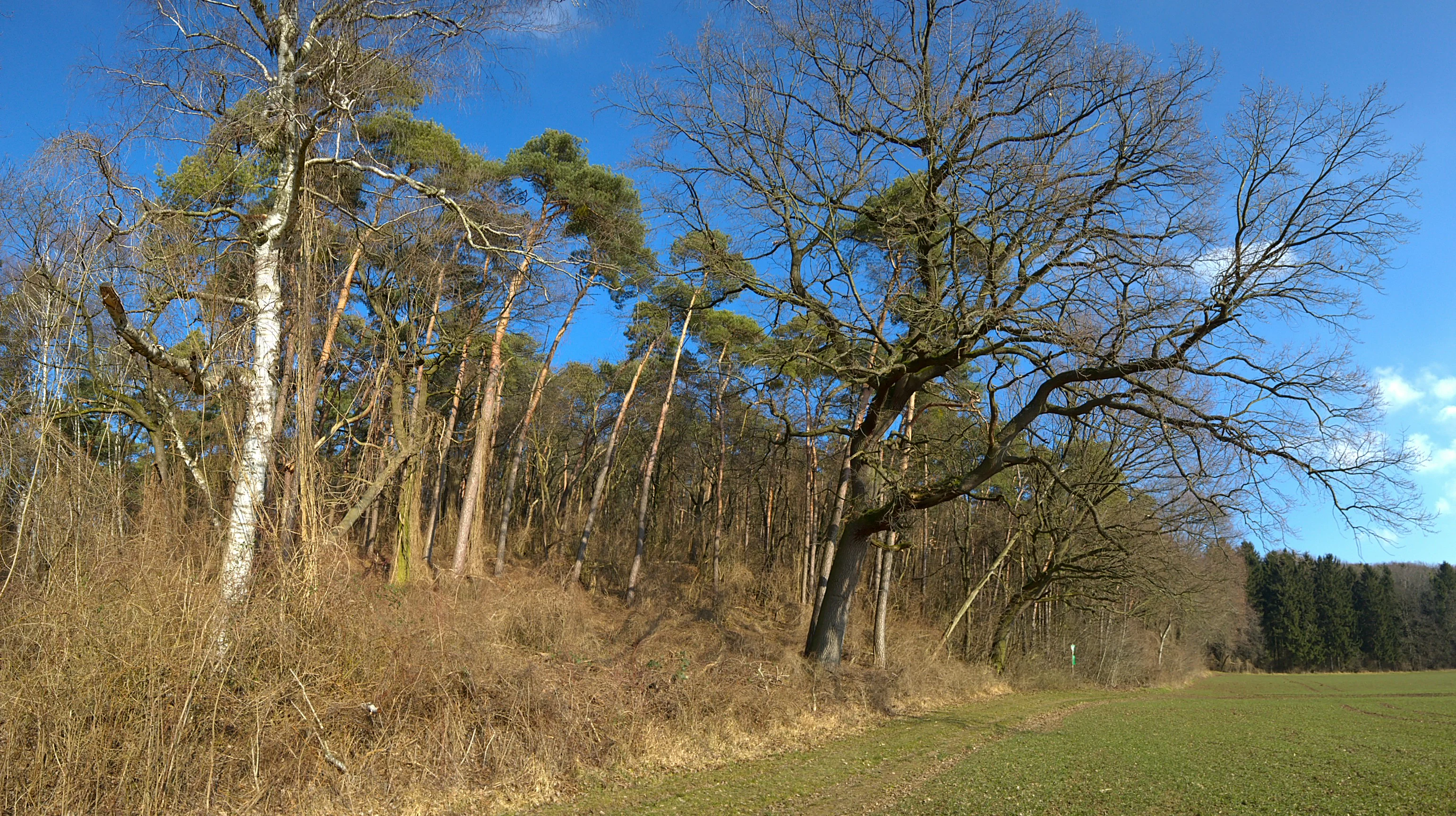
A line of bare deciduous trees and pine trees stands at the edge of a meadow under a bright blue sky.
Edge of the forest at Buchertsgräben bei Schlierbach featuring deciduous and coniferous trees under a clear sky.

Buchertsgräben bei Schlierbach history and protected-area timeline

The Buchertsgräben bei Schlierbach nature reserve was established by legal ordinance on 21 January 1986, formalizing decades of recognition of the area's ecological and geological value. Its designation reflects a broader German conservation movement of the 1980s, when many small but ecologically distinctive sites in Hesse were integrated into the Naturschutzgebiet network to safeguard remaining fragments of traditional cultural landscape.

The area's character, however, predates modern conservation. The loess gullies themselves are products of long-term erosion along historical paths, field boundaries, and formerly grazed slopes, meaning that much of what is now protected woodland was once part of an agricultural frontier between open fields and forest. Over time, as grazing pressure declined and forest re-expanded on the slopes, former dry grasslands transformed into the closed-canopy structure visible today, while the deepest and most erosion-prone slopes retained open vegetation patches. The 1986 designation sought to halt further changes and to actively preserve the remaining mosaic of habitats.

Since designation, the reserve has continued under the general protection of German federal and state nature conservation law. Its recent history has been shaped by climate-related stress, particularly the dry summer of 2018, which triggered significant dieback in the spruce stands within the area and is likely to influence future forest composition.

Buchertsgräben bei Schlierbach landscape and geographic character

The landscape of Buchertsgräben bei Schlierbach is defined by the contrast between forested ridge tops and deeply incised loess ravines. The reserve sits on the northern reaches of the Odenwald, where the highlands descend toward the Rhine-Main lowlands, and belongs to the Kleine Bergstraße natural area, a transitional strip of terrain that combines gentle hills, agricultural land, and stiffer forested slopes. Within the protected area, the most striking landforms are the deep loess gullies that run through the forest, locally referred to as Hohlwege or hollow ways.

These gullies create steep-sided valleys within the forest, with vertical or sharply sloped walls of fine, pale loess that visibly contrast with the surrounding woodland. The ravines break the hill slope into a network of crests, shoulders, and hollows, giving the otherwise modest terrain a strikingly varied topography. In places where the loess layer is thinnest or most eroded, the underlying transition toward Odenwald geology becomes visible, and small semi-open patches and former grassland relicts remain at the margins.

Surrounding the gorge-like interior, the broader countryside is dominated by open agricultural fields on flatter ground, which isolate the reserve as a wooded island in an otherwise cultivated landscape. This juxtaposition between enclosed, structurally complex forest and the surrounding open farmland is one of the defining visual qualities of the area.
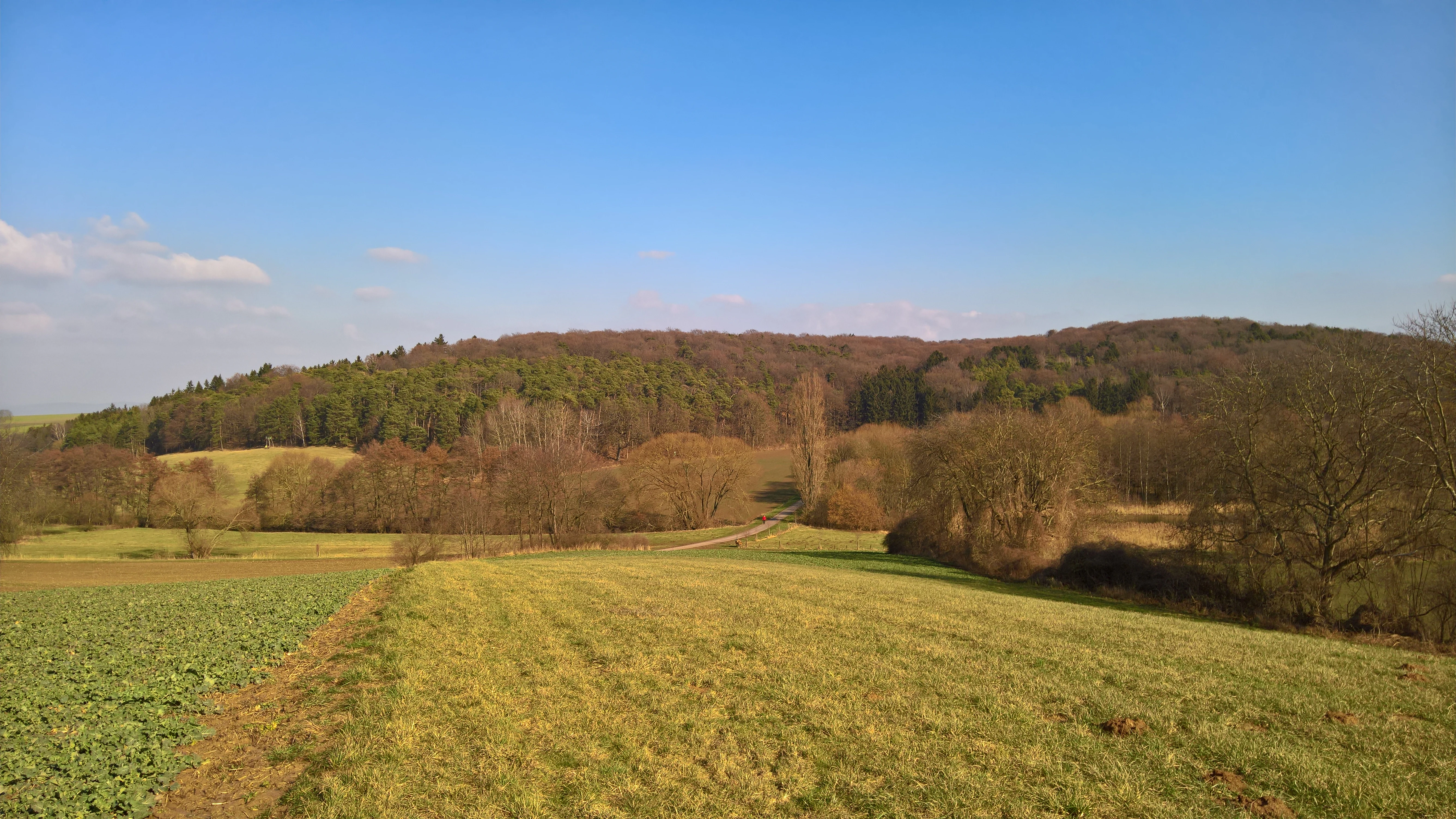
A rural landscape featuring a foreground of grassy meadows and agricultural fields, transitioning to dense, hilly deciduous forest under a clear blue sky.
A view of the Buchertsgräben bei Schlierbach nature reserve, showing the mix of meadows and deciduous forest typical of the Odenwald edge.

Buchertsgräben bei Schlierbach ecosystems, habitats, and plant life

Ecologically, Buchertsgräben bei Schlierbach is shaped by the unusual coexistence of mature woodland, dry grassland relicts, and loess-slope habitats within a single compact reserve. The dominant vegetation is a Luzulo-Fagetum, or Hainsimsen-Buchenwald, an association of beech forest typical of slightly acidic, moderately dry soils, which carpets most of the ridges and slopes. In small patches, planted spruce stands add an additional coniferous element, although these spruces have suffered significant dieback in response to the dry conditions of recent years.

On the sun-exposed loess slopes, the closed forest gives way to an open or semi-open vegetation that preserves fragments of the once more widespread Kalkmagerrasen, or calcareous dry grasslands. These patches harbor the botanical heart of the reserve. They support a suite of uncommon species typical of nutrient-poor, calcareous substrates, including the wild orchids for which the area is best known, along with plants such as Cross Gentian, Dwarf Elder, Adder's-tongue Fern, Wood Barley, and Round-leaved Bedstraw.

The combination of forest interior, open dry slopes, and steep loess walls creates the structural diversity that sustains the reserve's unusually rich invertebrate fauna, particularly butterflies, which benefit from the juxtaposition of sheltered woodland and warm, flowery open ground within a very short distance.

Buchertsgräben bei Schlierbach wildlife and species highlights

Although the reserve is small, its mosaic of habitats supports a strikingly rich fauna relative to its size. The combination of mature beech forest with sunny, herb-rich slopes and warm loess walls produces conditions that are favorable for invertebrates, and the reserve is particularly notable for its butterfly diversity. Visitors and surveyors have documented an unusually species-rich community of Lepidoptera, reflecting the favorable mix of larval food plants and microclimates.

The woodland itself provides habitat for typical central European forest fauna associated with old beech stands, including common forest birds, small mammals, and a range of insects tied to dead wood and herbaceous understory. The dry, exposed slopes also support specialized insects, including species that depend on the open, warm conditions that historically occurred across much larger areas of the Rhine-Main region.

The reserve's importance for wildlife is best understood in terms of habitat heterogeneity rather than charismatic large fauna. It functions as a refuge for many uncommon invertebrates and plants that have declined sharply across the broader agricultural landscape of southern Hesse, and it preserves a functional ecological network for species that move between forest and open ground.

Buchertsgräben bei Schlierbach conservation status and protection priorities

Conservation at Buchertsgräben bei Schlierbach is focused on maintaining the structural and biological complexity of a small but ecologically dense site. The legal designation of 21 January 1986 anchors the area within Germany's Naturschutzgebiet system, providing protection against land-use change, forestry intensification, and other direct threats. At the international level, the reserve is classified as IUCN Category IV, a Habitat/Species Management Area, reflecting its role in active conservation of specific habitats and species rather than purely passive protection.

The core conservation aim is to preserve the loess gullies and the associated woodland mosaic as a functional habitat complex. This includes safeguarding the dry-grassland relicts and orchids that depend on open, sun-exposed loess slopes, while also protecting the forest interior, the geological exposures, and the transitions between them. Because the site lies in a heavily agricultural setting, the reserve also serves as an important refugium for species that have largely disappeared from surrounding farmland.

A growing concern for the site is climate-driven forest change. The dry summer of 2018 triggered notable dieback in spruce stands within the reserve, pointing to a future in which forest composition will shift and management may need to respond. Ongoing conservation thus increasingly involves monitoring climate impacts, supporting the regeneration of more drought-tolerant native woodland, and ensuring that the open loess-slope habitats are not lost through either tree encroachment or erosion.

Buchertsgräben bei Schlierbach cultural meaning and human context

The reserve sits within a long-settled rural landscape on the southern fringe of the Odenwald, and its character reflects generations of interaction between people and terrain. The loess gullies themselves are partly cultural in origin, having been deepened and shaped by historical trackways, livestock paths, and the slow erosion of repeatedly walked slopes. Many of the dry grassland fragments that survive on the loess walls are remnants of a much more open landscape in which grazing, hay cutting, and low-intensity land use extended right up to the woodland edge.

Village and cadastral names in the surrounding area, including Schlierbach and Schaafheim itself, point to the agricultural communities whose traditional land use shaped both the surrounding fields and the forest edge. The reserve today represents the surviving wooded portion of that historical mosaic, preserving a landscape pattern that was once widespread across the Reinheimer Hügelland but has since been simplified by modern agriculture. The protected status of the area is in part a recognition of that historical and cultural dimension, not only of its biological value.

Top sights and standout views in Buchertsgräben bei Schlierbach

The reserve's most striking features are the deep loess gullies that cut through the beech forest, the unusual botanical richness of the dry-grassland relicts, and the geological significance of the exposures along the ravine walls. It is also notable for combining eight orchid species and an exceptionally rich butterfly fauna in a single compact site, functioning as a small but disproportionately valuable refugium for biodiversity in southern Hesse.

Best time to visit Buchertsgräben bei Schlierbach

Late spring and early summer are generally the most rewarding period to experience the reserve, when the orchid-rich dry slopes come into flower and the butterfly community is most active. The loess gullies are also easiest to appreciate visually when there is good light contrast between the pale loess walls and the surrounding green canopy, which tends to occur in late spring and early autumn. Winter visits can still reveal the topographic drama of the ravines, though the flora is largely dormant. The site should be approached in calm, dry weather, as the loess slopes can become slippery after rain and the deep gullies make for uneven walking at any time of year.

Monthly climate preview

Long term representative temperature and precipitation normals for Buchertsgräben bei Schlierbach

Buchertsgräben bei Schlierbach Climate Normals and Annual Weather Patterns

The recorded climatology tracks monthly temperature ranges and precipitation averages across the protected area coordinate. Reviewing complete monthly normals reveals long term seasonal rhythms without relying on live forecasts.
Annual mean10 °C
0 °C21 °C
Jan
Feb
Mar
Apr10°
May14°
Jun18°
Jul21°
Aug20°
Sep15°
Oct10°
Nov
Dec
Warmest month
July

20.6 °C

Coolest month
January

0.2 °C

Wettest month
July

2.2 mm/day

Driest month
April

1.4 mm/day

Park location guide

Geography guide, regional context, and park location map for Buchertsgräben bei Schlierbach

Buchertsgräben bei Schlierbach park geography, regions, and map view in Germany

Understand where Buchertsgräben bei Schlierbach sits in Germany through a broader geographic reading of the surrounding landscape, nearby location context, and its mapped position within the national park landscape.

How Buchertsgräben bei Schlierbach fits into Germany

Germany is a federal republic in Western and Central Europe with a population of over 83 million across sixteen constituent states. It is Europe's largest economy by nominal GDP and a major global exporter and importer. The capital is Berlin, and the country borders Denmark, Poland, Czech Republic, Austria, Switzerland, France, Luxembourg, Belgium, and the Netherlands.

Wider geography shaping Buchertsgräben bei Schlierbach in Germany

Germany is located in Western and Central Europe, spanning 357,022 km². It borders Denmark to the north, Poland and the Czech Republic to the east, Austria and Switzerland to the south, and France, Luxembourg, Belgium, and the Netherlands to the west. The country has coastlines on the Baltic Sea and North Sea to the north, with the Alps located in the southern region.

Map view of Buchertsgräben bei Schlierbach

Use this park location map to pinpoint Buchertsgräben bei Schlierbach in Germany, understand its exact geographic position, and read its mapped placement within the surrounding landscape more clearly.

Pigeon | © OpenStreetMap contributors

Location context for Buchertsgräben bei Schlierbach

Hessen

Visualizing deep loess gullies, beech woodlands, and protected habitats

Buchertsgräben bei Schlierbach Photos and Landscape Scenery

Visual records capture the distinctive topography of Buchertsgräben bei Schlierbach, revealing steep loess ravines and wooded ridge formations. Photographic documentation provides direct insight into the protected habitats, geological exposures, and varied microclimates of the Odenwald foothills.

A line of bare deciduous trees and pine trees stands at the edge of a meadow under a bright blue sky.

A wide, eye-level panoramic view of a deciduous forest in winter with bare trees, dry leaf-covered ground, and a small ridge in the midground under a bright blue sky.

A rural landscape featuring a foreground of grassy meadows and agricultural fields, transitioning to dense, hilly deciduous forest under a clear blue sky.

Park atlas

Compare surrounding Odenwald foothills and regional forest reserves

Parks near Buchertsgräben bei Schlierbach and Related Protected Landscapes

Browsing other protected areas near Buchertsgräben bei Schlierbach reveals shared geological features across the southern Hesse transition zone. Comparing adjacent forest reserves provides deeper geographic context for understanding regional loess ravines and woodland habitats.
A horizontal watercolor illustration of a soft, hazy landscape with rolling hills, meadows, and indistinct patches of vegetation against a light background.
Nature reserveHessen
About 6.4 km away#1 closest

Southeast

Bruchwiesen von Dorndiel Nature Reserve in Hessen: Protected Landscape and Geography

Wetland habitat and stream valley terrain in the Buntsandstein Odenwald

Bruchwiesen von Dorndiel represents a rare, compact concentration of wetland habitats, including open water, reedbeds, and moisture-gradient meadows. Located in the Amorbach stream corridor, this nature reserve is a key node for local biodiversity and regional landscape preservation within the broader Odenwald mountain range.

Area
0.087 km²
Established
1977
IUCN
IV
Relief
Upland
A horizontal watercolor painting depicting a soft-focus landscape with green fields, patches of wildflowers, and distant low hills.
Nature reserveHessen
About 7.7 km away#2 closest

Northwest

Auf dem Sand zwischen Hergershausen und Altheim Protected Nature Reserve in Hessen

Inland dune and floodplain landscape mapping

Explore the geography of Auf dem Sand zwischen Hergershausen und Altheim, a nature reserve in Hessen. The area serves as a critical habitat mosaic, featuring sandy inland dunes, expansive wet grasslands, and renaturalized floodplain terrain within the Gersprenz valley.

Area
0.233 km²
Established
1998
IUCN
IV
A soft watercolor illustration depicting a meadow landscape with a winding stream, distant hills, and foreground wildflowers.
Nature reserveHessen
About 8.3 km away#3 closest

Northwest

Die kleine Qualle von Hergershausen Nature Reserve and Protected Floodplain Landscapes

A preserved wetland fragment in the Hessen region

Die kleine Qualle von Hergershausen stands as a key protected area within the Gersprenz floodplain. This site offers a unique look at remnant wet meadow terrain, serving as an essential breeding and stopover ground for waterbirds in the Darmstadt-Dieburg district. Its geography provides a clear contrast to the surrounding agricultural fields, highlighting the impact of long-term conservation and habitat restoration efforts.

Area
0.27 km²
Established
1984
IUCN
IV
Watercolor painting of a wide, low-horizon landscape featuring a line of green trees against a pale pink sky over a pale, sandy foreground.
Nature reserveHessen
About 8.4 km away#4 closest

South

Sandsteinbrüche am Burzelberg bei Frau-Nauses Protected Nature Reserve and Quarry Atlas

Odenwald mountain range, Hessen protected area

Examine the geography of Sandsteinbrüche am Burzelberg bei Frau-Nauses, a protected nature reserve in Hessen. This site features striking Buntsandstein quarry walls and rewilded forest edges, providing a specialized environment for cliff-nesting raptors and documenting local industrial history through its geological formations.

Area
0.195 km²
Established
1994
Relief
Upland
Climate
Temperate
Watercolor painting of a soft landscape showing a light orange foreground, a band of green trees and bushes in the midground, and faint rolling hills against a pale yellow sky in the background.
Nature reserveLandkreis Darmstadt-Dieburg
About 8.6 km away#5 closest

Northwest

Brackenbruch bei Hergershausen: Nature Reserve and Floodplain Ecosystem in Darmstadt-Dieburg

Protected wetland landscapes and Lache stream geography

Located in the Darmstadt-Dieburg district, Brackenbruch bei Hergershausen preserves a characteristic lowland floodplain mosaic. The terrain includes wet meadows, reed beds, and developing oak-hornbeam forests that reflect the natural vegetation of the southern Hessian river valleys. This site maintains essential wetland habitats for regional biodiversity within its protected boundaries.

Area
0.523 km²
Established
1999
A soft watercolor painting showing a tranquil wetland landscape with calm water, grassy shores, and hazy mountains in the background.
Nature reserveHessen
About 10 km away#6 closest

Northwest

Kies- und Sandgrube von Dudenhofen: Regional Nature Reserve and Wetland Mapping

Protected post-extraction landscape in the Hessen region

Kies- und Sandgrube von Dudenhofen protects a distinct network of shallow-water habitats and open-ground terrain near Rodgau. Managed as a nature reserve, this area serves as an essential regional hub for wetland biodiversity, mapping the transition between industrial remnants and regenerated forest ecosystems within the Rhine-Main lowlands.

Area
0.173 km²
Established
1995
IUCN
IV
Nature reserveHessen
About 11 km away#7 closest

North

Mooskiefernwald von Dudenhofen: Mapped Nature Reserve and Protected Pine Woodland in Hessen

Regional landscape context and protected area boundaries

Study the geographic composition of Mooskiefernwald von Dudenhofen, a specialized nature reserve in Hessen. This 36-hectare site features a rare moss-pine woodland environment and sandy soil habitats, offering a distinct contrast to the industrial and suburban landscape of the Rodgau area.

Area
0.361 km²
Established
1999
IUCN
IV
A horizontal watercolor painting showing a calm lake with marshy shores, distant tree lines, and pine branches framing the top and bottom corners, rendered in soft pastel greens and pinks.
Nature reserveHessen
About 11 km away#8 closest

North

Ehemalige Tongrube von Mainhausen: Protected Nature Reserve and Wetland Habitat in Hessen

A vital sanctuary for waterbirds in the lower Main river valley

Explore the Ehemalige Tongrube von Mainhausen, an essential protected area in Hessen, Germany. Formed from a former clay pit, this site preserves a 15 hectare lake and diverse floodplain vegetation, functioning as a vital breeding and resting ground for numerous waterfowl species within the heavily modified lower Main valley.

Area
0.156 km²
Established
2005
IUCN
IV
Relief
Lowland

Common questions about visiting, size, designation, and location context for Buchertsgräben bei Schlierbach

Buchertsgräben bei Schlierbach FAQs for park facts, access, geography, and protected area context

Find quick answers about Buchertsgräben bei Schlierbach, including protected-area facts, park geography, trail and visitor context, and how the park fits into its surrounding country and regional landscape.
MoriAtlas Explorer

Continue Your Protected Areas Search Across the Global Atlas

Deepen your exploration by continuing the structured search for national parks and protected areas worldwide. Utilize the comprehensive filtering capabilities to compare different conservation landscapes and refine your understanding of global park geography. Discover more about the distribution and characteristics of protected natural areas.

Global natural geography