

Mori Atlas logo
National parkByeonsan-bando National Park

Discover the mapped boundaries and natural terrain of this national park in Jeollabuk-do.

Byeonsan-bando National Park: South Korea's Protected Landscape Identity and Regional Geography

(Byeonsan-bando National Park (변산반도국립공원))

Byeonsan-bando National Park represents a significant protected natural area within South Korea, situated in the Jeollabuk-do region. This page offers an atlas-focused exploration of its protected landscape, detailing its geographic setting and mapped boundaries. Understand the park's unique place within the regional geography and discover the core aspects of its protected natural terrain, vital for understanding Korea's conservation landscapes.

Coastal ParkPeninsula LandscapeMountain and SeaMarine Protected AreaKorean National ParkYellow Sea

Byeonsan-bando National Park

National park

Park overview

Structured park overview, official facts, and landscape profile for Byeonsan-bando National Park

Byeonsan-bando National Park park facts, protected area profile, and essential visitor context
Review the core facts for Byeonsan-bando National Park, including designation, size, terrain, visitor scale, habitats, and operating context in one park-focused overview.

About Byeonsan-bando National Park

Byeonsan-bando National Park occupies a prominent position along South Korea's southwestern coast, where the Korean Peninsula extends into the Yellow Sea through a distinctive peninsula formation. The park's geography is defined by this peninsula structure, which creates a landscape of considerable visual and ecological complexity. The mountain area, Naebyeonsan, features forested slopes and ridgelines that rise from the interior of the peninsula, while the coastal area, Oebyeonsan, encompasses the surrounding cliffs, coves, small islands, and the marine waters that lap against the peninsula's shores. This configuration makes Byeonsan-bando visually distinctive among South Korea's national parks, as visitors can experience both mountain hiking environments and coastal exploration within the same protected area. The park's establishment in 1988 reflected a recognition of the peninsula's combined scenic and ecological values, marking it as a priority for protection within South Korea's developing national park system. The park's location in Jeollabuk-do places it within a region known for its agricultural character and coastal communities, adding cultural context to the natural landscape.

Quick facts and research context for Byeonsan-bando National Park

Located in Jeollabuk-do Province, southwestern South Korea, Byeonsan-bando is the only national park in Korea designated around a peninsula formation. The park was established in 1988 and encompasses both mountain and marine environments, spanning roughly 155 square kilometers with about 9 square kilometers of sea area. The protected area supports remarkable biodiversity, with 996 animal species and 877 vascular plant species documented within its boundaries. The park is managed by the Korea National Park Service and represents an important example of South Korea's conservation system.

Park context

Deeper park guide and search-rich context for Byeonsan-bando National Park

Byeonsan-bando National Park history, landscape, wildlife, and travel context
Explore Byeonsan-bando National Park through its history, landscape character, ecosystems, wildlife, conservation priorities, cultural context, and seasonal travel timing in a structured park guide built for atlas discovery and search intent.

Why Byeonsan-bando National Park stands out

Byeonsan-bando National Park is most notably recognized as South Korea's unique peninsula-based protected area, where mountainous landscapes transition directly into coastal and marine environments. The park's defining characteristic is this seamless integration of mountain and sea, offering visitors the experience of traversing forested peaks while being within sight and sound of the ocean. The contrast between the rocky, forested slopes of Naebyeonsan and the coastal cliffs, beaches, and islands of Oebyeonsan creates a scenic diversity uncommon among Korean national parks. This peninsula formation also provides important ecological value, supporting both terrestrial and marine species in a transitional coastal zone.

Byeonsan-bando National Park history and protected-area timeline

Byeonsan-bando National Park was officially designated on June 11, 1988, becoming a protected area of national significance within South Korea's national park framework. The park's establishment reflected growing environmental awareness in South Korea during the 1980s and a governmental commitment to preserving representative examples of the nation's natural landscapes. What makes Byeonsan-bando particularly notable is its selection as the only national park in South Korea organized around a peninsula formation, recognizing the unique scenic and ecological values that emerge when mountain terrain meets the sea along a projecting landform. The decision to protect this peninsula area also acknowledged the biodiversity significance of transitional coastal environments, where terrestrial and marine ecosystems intersect. Management responsibility was assigned to the Korea National Park Service, which continues to oversee the park's protection and visitor services. The park's designation as a Category II protected area under the International Union for Conservation of Nature classification confirms its primary purpose of protecting natural ecosystems while allowing sustainable visitor access.

Byeonsan-bando National Park landscape and geographic character

The landscape of Byeonsan-bando National Park is defined by the interaction between elevated terrain and coastal exposure along a peninsula extending into the Yellow Sea. The park's mountain areas feature slopes covered with mixed forest vegetation, creating a green backdrop visible from the coast. Ridgelines and valleys create topographic variation within the inland portions, offering visitors opportunities for hiking and scenic observation. The coastal landscape is characterized by rocky cliffs, small beaches, and the numerous islands that scatter across the adjacent marine waters. The interface between land and sea produces distinctive features including sea cliffs, coastal bluffs, and sheltered coves along the peninsula's margins. The marine component of the park, encompassing approximately 9 square kilometers of sea area, extends protection to the waters surrounding the peninsula and its outlying islands. This combination of mountain, coastal, and marine landscapes within a single protected area creates a coherent ecological and visual unit that distinguishes Byeonsan-bando from other Korean national parks.

Byeonsan-bando National Park ecosystems, habitats, and plant life

The ecological character of Byeonsan-bando National Park reflects its position at the intersection of terrestrial and marine environments along South Korea's southwestern coast. The park supports significant biodiversity, with 877 vascular plant species documented within its boundaries, reflecting the variety of habitats from coastal zones to forest-covered slopes. The animal community encompasses 996 species, indicating the ecological productivity of this coastal protected area. The transitional nature of the peninsula environment creates conditions suitable for both terrestrial and marine species, with the park protecting habitats that might otherwise face development pressure along this populated coast. Forest ecosystems occupy the inland slopes, while coastal areas support vegetation adapted to salt exposure and marine influence. The marine portion of the park protects water quality and ecological processes in the surrounding seas, contributing to the broader coastal ecosystem health of the region.

Byeonsan-bando National Park wildlife and species highlights

Byeonsan-bando National Park supports a diverse animal community of 996 species, reflecting the ecological productivity of its coastal peninsula setting. The park's combination of forest, coastal, and marine habitats creates environments suitable for a variety of wildlife groups. Birdlife is particularly notable in coastal and island areas, where migratory species utilize the peninsula as a stopping point along East Asian flyways. The marine environment supports fish populations and other sea life that inhabit the protected waters surrounding the peninsula. Forest areas provide habitat for terrestrial species adapted to the deciduous and mixed forest environments of southwestern Korea. The protection afforded by national park status helps maintain wildlife populations in an area where coastal development pressures exist, preserving ecological connectivity between terrestrial and marine food webs.

Byeonsan-bando National Park conservation status and protection priorities

The designation of Byeonsan-bando as a national park reflects its conservation significance within South Korea's protected area network. As the only peninsula-based national park in the country, the park protects a rare landscape type where mountain and coastal environments exist in close integration. The protection of approximately 154.71 square kilometers of terrestrial and marine landscapes preserves important habitats for the park's documented 996 animal species and 877 vascular plant species. The marine component of the park contributes to coastal ecosystem protection, maintaining water quality and ecological processes in the surrounding Yellow Sea waters. The park's management under the Korea National Park Service ensures ongoing protection while providing visitor access in a sustainable manner. This conservation framework addresses the particular vulnerability of coastal environments to development pressures, preserving the peninsula's natural values for current and future generations.

Byeonsan-bando National Park cultural meaning and human context

Byeonsan-bando National Park is situated in Jeollabuk-do Province, a region of South Korea known for its agricultural productivity and coastal communities. The peninsula has historically supported fishing and farming activities that shaped local settlement patterns and cultural traditions. The landscape's natural beauty has been appreciated within Korean cultural traditions, with the peninsula's distinctive profile contributing to regional identity. While the park itself focuses on natural protection, the surrounding areas maintain connections to traditional land and sea use practices. The park's establishment in 1988 came during a period of expanded environmental protection in South Korea, reflecting broader societal recognition of natural landscape values. Visitors to the park today experience both the natural environments and the cultural context of this coastal region.

Top sights and standout views in Byeonsan-bando National Park

The defining highlight of Byeonsan-bando National Park is its unique status as South Korea's only peninsula-based national park, where the rare combination of mountain and marine environments creates a distinctive protected landscape. The park offers visitors the opportunity to experience both forested mountain trails and coastal exploration within a single visit, with the peninsula formation providing dramatic viewpoints where land meets sea. The biological richness of the park, supporting nearly 900 plant species and almost 1,000 animal species, underscores its ecological significance. The marine portion of the park protects the waters surrounding the peninsula and its islands, preserving underwater environments alongside the terrestrial landscape. This integration of multiple landscape types within one protected area makes Byeonsan-bando particularly valuable for both conservation and visitor experience.

Best time to visit Byeonsan-bando National Park

Byeonsan-bando National Park can be visited throughout the year, with each season offering different characteristics for exploration. Spring and autumn typically provide comfortable temperatures for hiking and outdoor activities, with the park's forests displaying seasonal color changes. Summer months bring warmer conditions and increased visitor activity, with the coastal areas offering opportunities to experience the marine environment. Winter visits offer a quieter experience with fewer visitors, though conditions may be cooler for outdoor exploration. The park's coastal location means that weather patterns can include sea breezes and the influence of maritime conditions, which visitors should consider when planning activities. The combination of mountain and coastal environments means that conditions can vary across the park's different areas, allowing for diverse experiences depending on location within the protected area.
Park location guide

Geography guide, regional context, and park location map for Byeonsan-bando National Park

Byeonsan-bando National Park park geography, regions, and map view in South Korea
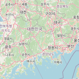
Understand where Byeonsan-bando National Park sits in South Korea through a broader geographic reading of the surrounding landscape, nearby location context, and its mapped position within the national park landscape.

How Byeonsan-bando National Park fits into South Korea

South Korea is a presidential republic on the Korean Peninsula in East Asia. It has a population of about 51 million and Seoul as its capital and largest city. The country is known for its rapid economic development, high technology industry, and cultural exports.

Wider geography shaping Byeonsan-bando National Park in South Korea

South Korea occupies the southern half of the Korean Peninsula in East Asia. It borders North Korea along the Demilitarized Zone to the north, the Yellow Sea to the west, and the Sea of Japan to the east. The terrain is predominantly mountainous with coastal plains along the southern and eastern shores.

Map view of Byeonsan-bando National Park

Use this park location map to pinpoint Byeonsan-bando National Park in South Korea, understand its exact geographic position, and read its mapped placement within the surrounding landscape more clearly.

Pigeon | © OpenStreetMap contributors

Location context for Byeonsan-bando National Park

Jeollabuk-do
Park atlas

Explore the regional park geography, compare unique protected areas, and trace coastal landscapes across the Korean Peninsula

Discover Other National Parks Near Byeonsan-bando National Park and Explore South Korea's Protected Coastal Landscapes
Expand your atlas of South Korean protected areas by comparing national parks and diverse regional landscapes adjacent to Byeonsan-bando National Park. Trace the geographic spread of distinct coastal, mountain, and peninsula-based conservation zones to understand the country's varied natural environments and park entities.
National parkSouth Korea

Naejangsan National Park: South Korea's Mapped Protected Landscape and Geography

Discover the park's protected boundaries and regional context.

Investigate Naejangsan National Park, a protected area within South Korea, through its mapped geography and landscape context. This detailed atlas entry provides insight into the park's specific geographic identity and its role as a national park, offering a structured understanding of its protected natural features for focused exploration and research.

Area
81.45 km²
Established
1971
IUCN
II
Relief
Mountain
National parkJeollanam-do

Mudeungsan National Park: Mapped Protected Landscape and Regional Geography Context

Explore Mudeungsan National Park's geographic setting in Jeollanam-do.

Mudeungsan National Park offers a distinct protected landscape within the Jeollanam-do region of South Korea. This atlas-focused page details its mapped geographic boundaries and the surrounding natural terrain, providing essential context for understanding its role as a national park. Explore the park's identity through its unique landscape and regional geography.

Area
75.45 km²
Established
2012
IUCN
II
Relief
Mountain
National parkChungcheongnam-do

Gyeryongsan National Park: Mapped Protected Landscape in Chungcheongnam-do

Explore its national park designation and regional geography.

Gyeryongsan National Park is a formally protected national park in Chungcheongnam-do, South Korea. This page offers critical atlas context for understanding the park's geographic scope, mapped protected boundaries, and its significance as a natural landscape within the region. Examine the terrain and explore its regional context for a deeper appreciation of its protected status.

Area
64.71 km²
Established
1968
IUCN
II
Relief
Mountain
National parkJeollanam-do

Wolchulsan National Park: Detailed Geographic and Protected Landscape Atlas Entry

Explore mapped boundaries and natural terrain context.

This MoriAtlas entry for Wolchulsan National Park provides a detailed look at its identity as a protected landscape within Jeollanam-do, South Korea. Focus is placed on its geographic context and mapped park boundaries, offering a foundation for understanding its place in the regional atlas. Discover the structured details of this national park's natural terrain and its significance as a preserved natural area.

Area
56.6 km²
Established
1988
IUCN
II
Relief
Mountain
National parkSouth Korea

Jirisan National Park: South Korea's Premier Protected Landscape and Map Resource

Explore the mapped terrain and protected area geography.

Jirisan National Park is a key protected area within South Korea, serving as a vital component of the nation's natural landscape. This atlas-focused content provides detailed geographic information, highlighting the park's mapped boundaries and its role within the regional context of the Korean Peninsula. Understand the distinct characteristics of this protected national park for comprehensive geographic discovery.

Area
471.75 km²
Established
1967
IUCN
II
Visitors
1.5M annual
National parkJeollabuk-do

Deogyusan National Park: National Park Identity and Geographic Mapping

Explore its protected land boundaries and regional landscape context.

Examine Deogyusan National Park, a designated national park situated in the Jeollabuk-do region of South Korea. This entry provides critical geographic context, focusing on the park's mapped boundaries and its role as a protected landscape. Users can gain a structured understanding of its natural terrain and regional significance, contributing to a broader atlas of protected areas.

Area
231.65 km²
Established
1975
IUCN
V
Visitors
1M annual
National parkSouth Korea

Taean Seaside National Park: National Park Geography and Mapped Landscape Discovery

South Korea's protected coastal terrain.

Explore the precise geographic identity of Taean Seaside National Park, a key protected area within South Korea. This page offers an atlas-style perspective on its landscape context, mapped boundaries, and regional distribution across the Korean Peninsula. Understand its role as a national park and its contribution to the mapped natural terrain of East Asia.

Area
840 km²
Established
1978
IUCN
II
Relief
Lowland
National parkSouth Gyeongsang Province

Gayasan National Park: National Park Identity and Mapped Geographic Context in South Korea

Discover Protected Landscape and Regional Terrain

Gayasan National Park presents a distinct protected-area entity within South Gyeongsang Province, serving as a crucial point for atlas-driven geographic exploration. As a designated national park in South Korea, it offers insights into its specific mapped boundaries and the surrounding natural terrain. Understanding this park's role within the regional geography provides a foundational element for comprehending broader landscape patterns and protected land distribution across the country.

Area
167.6 km²
Established
1972
IUCN
II
Relief
Mountain

Common questions about visiting, size, designation, and location context for Byeonsan-bando National Park

Byeonsan-bando National Park FAQs for park facts, access, geography, and protected area context
Find quick answers about Byeonsan-bando National Park, including protected-area facts, park geography, trail and visitor context, and how the park fits into its surrounding country and regional landscape.
MoriAtlas Explorer

Continue Your Protected Areas Search Across the Global Atlas

Deepen your exploration by continuing the structured search for national parks and protected areas worldwide. Utilize the comprehensive filtering capabilities to compare different conservation landscapes and refine your understanding of global park geography. Discover more about the distribution and characteristics of protected natural areas.

Global natural geography