

Mori Atlas logo
National parkDeogyusan National Park

Trace the mapped boundaries and natural terrain of this significant national park.

Deogyusan National Park: Protected Landscape and Geographic Context in Jeollabuk-do

(Deogyusan National Park (덕유산국립공원))

Deogyusan National Park stands as a protected landscape within South Korea's Jeollabuk-do region. This atlas-focused entry details the park's geographic setting, allowing for exploration of its natural terrain and mapped boundaries. Understand the distinct identity of Deogyusan National Park as a key protected area, offering essential geographic context for regional landscape discovery.

National ParkMountain LandscapeTemperate ForestBaekdu-daeganBiodiversity HotspotSouth Korea

Deogyusan National Park

National park

Park overview

Structured park overview, official facts, and landscape profile for Deogyusan National Park

Deogyusan National Park park facts, protected area profile, and essential visitor context
Review the core facts for Deogyusan National Park, including designation, size, terrain, visitor scale, habitats, and operating context in one park-focused overview.

About Deogyusan National Park

Deogyusan National Park represents one of South Korea's most ecologically significant mountain protected areas, preserving a substantial portion of the Baekdu-daegan ridge system in the country's southwestern region. The park's establishment in 1975 reflected growing recognition of the need to protect Korea's remaining wild mountain landscapes and the ecological corridors they provide. The reserve spans a transition zone between the more humid southern coastal climate patterns and the continental influences from the north, creating ecological conditions that support both northern and southern species. The Korea National Park Service maintains visitor facilities and hiking trails throughout the mountain, with the summit area and ridge trails drawing the majority of visitors seeking to experience the park's scenic landscapes and natural environments.

Quick facts and research context for Deogyusan National Park

Deogyusan National Park is located in southwestern South Korea, straddling Jeollabuk-do and Gyeongsangnam-do provinces with Muju County as the nearest major settlement. The park covers 231.65 square kilometers and was established in 1975 as the tenth of South Korea's national parks. It is managed by the Korea National Park Service and receives approximately one million visitors annually. The park contains over 1,000 plant species and supports significant populations of mammals, birds, and insects, with flying squirrel, marten, and otter listed as endangered species.

Park context

Deeper park guide and search-rich context for Deogyusan National Park

Deogyusan National Park history, landscape, wildlife, and travel context
Explore Deogyusan National Park through its history, landscape character, ecosystems, wildlife, conservation priorities, cultural context, and seasonal travel timing in a structured park guide built for atlas discovery and search intent.

Why Deogyusan National Park stands out

Deogyusan National Park is particularly known for its dramatic mountain scenery and its position along the Baekdu-daegan, the mountain ridge considered the spiritual backbone of the Korean Peninsula. The park's Hyangjeok Peak offers panoramic views of the surrounding landscape and is a signature viewpoint within the reserve. The mountain supports one of the most diverse collections of plant and animal species among South Korea's protected areas, with particularly notable concentrations of temperate forest flora and the presence of several protected mammal species including flying squirrels, martens, and otters. The park also stands out for its seasonal beauty, with spring alpine flowers, summer forest canopy, autumn color, and winter snow creating distinct visiting experiences throughout the year.

Deogyusan National Park history and protected-area timeline

Deogyusan National Park was designated as South Korea's tenth national park on February 1, 1975, representing a milestone in the country's emerging national park system. The selection of Deogyusan for protection reflected the mountain's status as a prominent peak along the Baekdu-daegan, the long mountain ridge running the length of the Korean Peninsula that holds cultural and ecological significance. Prior to national park designation, the area had been subject to traditional land uses including forestry and limited agriculture in the lower elevations. The establishment of the park brought formalized protection to the mountain's forests, wildlife habitats, and scenic values, with management authority transferred to the Korea National Park Service. The park has since become a destination for both recreation and environmental education, welcoming approximately one million visitors annually.

Deogyusan National Park landscape and geographic character

Deogyusan rises as a prominent mountain within the Baekdu-daegan system, with steep-sided valleys and rocky ridgelines defining the park's physical character. The terrain includes numerous small streams descending through forested slopes into broader valleys at lower elevations. The mountain's geology creates a landscape of exposed rock faces, boulder-strewn slopes, and forest-covered ridges that vary in character with elevation. From Hyangjeok Peak, the park's primary summit viewpoint, visitors can observe the extent of the forested landscape stretching toward the horizon in multiple directions. The combination of elevation change, varied topography, and the mix of deciduous and evergreen forest creates a visually diverse mountain landscape that changes substantially with the seasons.

Deogyusan National Park ecosystems, habitats, and plant life

The ecological diversity of Deogyusan National Park is one of its defining characteristics, with the protected area supporting over 1,067 plant species, representing the full range of Korean temperate forest vegetation. The forests transition from mixed deciduous forest in the lower elevations through conifer-dominated forests at higher altitudes, creating distinct ecological zones throughout the park. The park's location at a transition point between different climate influences supports species from both northern and southern biogeographic origins. Beyond the forests, the park contains aquatic habitats in its streams and wetlands that support additional biodiversity. The variety of habitats within the relatively compact mountain area creates conditions for a rich overall species community.

Deogyusan National Park wildlife and species highlights

Deogyusan National Park supports significant wildlife populations across multiple vertebrate groups, including 32 mammal species, 130 bird species, 9 amphibian species, 13 reptile species, and 28 fish species, along with over 1,300 insect species. Three mammal species found in the park are classified as endangered: the flying squirrel, marten, and otter. These species represent the park's conservation significance beyond simple species counts, as their presence indicates healthy ecosystem functioning and appropriate habitat conditions. The bird diversity includes both resident species and migratory visitors that use the mountain as a seasonal habitat. The combination of forest-dwelling mammals, stream-associated species, and the broader invertebrate community creates a wildlife profile that reflects the park's diverse habitats and relatively intact ecological conditions.

Deogyusan National Park conservation status and protection priorities

The designation of Deogyusan National Park as an IUCN Category V protected landscape reflects its role in preserving both natural values and the traditional landscape character of the mountain region. Category V status recognizes that the area maintains a harmonious relationship between human activities and the natural environment, rather than representing a strictly wilderness area. The park's conservation value is enhanced by its position along the Baekdu-daegan, which functions as an ecological corridor connecting protected areas across the Korean Peninsula. The presence of endangered species including flying squirrel, marten, and otter demonstrates the park's continued habitat quality and the effectiveness of protection measures implemented since 1975.

Deogyusan National Park cultural meaning and human context

While the primary focus of Deogyusan National Park is ecological preservation, the mountain and surrounding region have historical connections to Korean cultural traditions associated with the Baekdu-daegan ridge system. The Baekdu-daegan is traditionally understood as the spiritual spine of the Korean Peninsula, with various peaks along the ridge holding significance in historical and cultural contexts. The park exists within a landscape where traditional land uses shaped the environment prior to protected area establishment, and the surrounding rural communities maintain connections to the mountain that predate national park designation.

Top sights and standout views in Deogyusan National Park

Deogyusan National Park offers visitors a combination of scenic mountain landscapes, ecological diversity, and outdoor recreation opportunities within a protected setting. Hyangjeok Peak provides the park's most celebrated viewpoint, with hiking trails to the summit allowing visitors to experience the mountain's varied terrain and panoramic views. The seasonal changes in the park create distinctly different experiences across the year, from spring wildflower displays to autumn foliage colors to winter snow-covered ridgelines. The trail network accommodates various fitness levels while preserving access to the mountain's most scenic and ecologically significant areas. The park's biodiversity, with over 1,000 plant species and numerous animal species including three endangered mammals, demonstrates the ecological health of the protected area.

Best time to visit Deogyusan National Park

Deogyusan National Park offers rewarding experiences throughout the seasons, each bringing distinct character to the mountain landscape. Spring brings alpine flowers blooming on higher slopes as temperatures warm, with forest floors covered in seasonal wildflowers. Summer offers full forest canopy and the opportunity to enjoy shaded trails through the mountain's valleys and ridges. Autumn transforms the deciduous forests into vivid displays of red, orange, and gold foliage, making this season particularly popular among visitors. Winter creates a different landscape entirely, with snow-covered peaks and bare trees offering a starkly beautiful environment for those who enjoy cold-season hiking. The choice of when to visit depends on whether visitors prefer the vibrant colors of autumn, the flowers of spring, the greenery of summer, or the quiet beauty of winter.

Park location guide

Geography guide, regional context, and park location map for Deogyusan National Park

Deogyusan National Park park geography, regions, and map view in South Korea
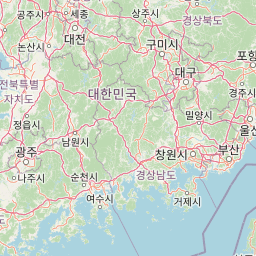
Understand where Deogyusan National Park sits in South Korea through a broader geographic reading of the surrounding landscape, nearby location context, and its mapped position within the national park landscape.

How Deogyusan National Park fits into South Korea

South Korea is a presidential republic on the Korean Peninsula in East Asia. It has a population of about 51 million and Seoul as its capital and largest city. The country is known for its rapid economic development, high technology industry, and cultural exports.

Wider geography shaping Deogyusan National Park in South Korea

South Korea occupies the southern half of the Korean Peninsula in East Asia. It borders North Korea along the Demilitarized Zone to the north, the Yellow Sea to the west, and the Sea of Japan to the east. The terrain is predominantly mountainous with coastal plains along the southern and eastern shores.

Map view of Deogyusan National Park

Use this park location map to pinpoint Deogyusan National Park in South Korea, understand its exact geographic position, and read its mapped placement within the surrounding landscape more clearly.

Pigeon | © OpenStreetMap contributors

Location context for Deogyusan National Park

Gyeongsangnam-doJeollabuk-do
Park atlas

Trace South Korea's Mountain Protected Landscapes, Comparing Regional Park Geography with Deogyusan

Discover Nearby National Parks and Protected Areas Beyond Deogyusan National Park
Delve into the wider network of national parks and protected areas surrounding Deogyusan National Park across South Korea's Baekdu-daegan mountain spine. Compare diverse mountain landscapes, temperate forests, and regional conservation efforts to understand their geographic spread and ecological connections.
National parkSouth Gyeongsang Province

Gayasan National Park: National Park Identity and Mapped Geographic Context in South Korea

Discover Protected Landscape and Regional Terrain

Gayasan National Park presents a distinct protected-area entity within South Gyeongsang Province, serving as a crucial point for atlas-driven geographic exploration. As a designated national park in South Korea, it offers insights into its specific mapped boundaries and the surrounding natural terrain. Understanding this park's role within the regional geography provides a foundational element for comprehending broader landscape patterns and protected land distribution across the country.

Area
167.6 km²
Established
1972
IUCN
II
Relief
Mountain
National parkSouth Korea

Jirisan National Park: South Korea's Premier Protected Landscape and Map Resource

Explore the mapped terrain and protected area geography.

Jirisan National Park is a key protected area within South Korea, serving as a vital component of the nation's natural landscape. This atlas-focused content provides detailed geographic information, highlighting the park's mapped boundaries and its role within the regional context of the Korean Peninsula. Understand the distinct characteristics of this protected national park for comprehensive geographic discovery.

Area
471.75 km²
Established
1967
IUCN
II
Visitors
1.5M annual
National parkChungcheongnam-do

Gyeryongsan National Park: Mapped Protected Landscape in Chungcheongnam-do

Explore its national park designation and regional geography.

Gyeryongsan National Park is a formally protected national park in Chungcheongnam-do, South Korea. This page offers critical atlas context for understanding the park's geographic scope, mapped protected boundaries, and its significance as a natural landscape within the region. Examine the terrain and explore its regional context for a deeper appreciation of its protected status.

Area
64.71 km²
Established
1968
IUCN
II
Relief
Mountain
National parkSouth Korea

Songnisan National Park: Mapped Protected Landscape and Geographic Context in South Korea

Discover South Korea's Songnisan National Park and its protected terrain.

Delve into the protected landscape of Songnisan National Park, a key national park entity in South Korea. This atlas-focused view highlights its mapped geographic boundaries and natural terrain, providing essential context for understanding conservation areas. Explore Songnisan National Park as a distinct protected region contributing to the country's diverse geography and mapped natural heritage.

Area
274.541 km²
Established
1970
IUCN
II
Relief
Mountain
National parkSouth Korea

Naejangsan National Park: South Korea's Mapped Protected Landscape and Geography

Discover the park's protected boundaries and regional context.

Investigate Naejangsan National Park, a protected area within South Korea, through its mapped geography and landscape context. This detailed atlas entry provides insight into the park's specific geographic identity and its role as a national park, offering a structured understanding of its protected natural features for focused exploration and research.

Area
81.45 km²
Established
1971
IUCN
II
Relief
Mountain
National parkJeollanam-do

Mudeungsan National Park: Mapped Protected Landscape and Regional Geography Context

Explore Mudeungsan National Park's geographic setting in Jeollanam-do.

Mudeungsan National Park offers a distinct protected landscape within the Jeollanam-do region of South Korea. This atlas-focused page details its mapped geographic boundaries and the surrounding natural terrain, providing essential context for understanding its role as a national park. Explore the park's identity through its unique landscape and regional geography.

Area
75.45 km²
Established
2012
IUCN
II
Relief
Mountain
National parkJeollabuk-do

Byeonsan-bando National Park: Protected Landscape and Geographic Context in Jeollabuk-do

Explore mapped terrain and regional park geography.

This detail page provides an in-depth look at Byeonsan-bando National Park, a protected area located in South Korea's Jeollabuk-do region. Users can discover the park's specific geographic identity, understand its mapped boundaries, and explore its role within the broader regional landscape. The content is structured for atlas exploration, offering detailed insights into the park's natural terrain and its significance as a national park.

Area
154.71 km²
Established
1988
IUCN
II
Relief
Mixed relief
Watercolor illustration of green hills, a body of water, and mountain peaks under a soft sky
National parkGyeongsangbuk-do

Woraksan National Park: A Key National Park in Gyeongsangbuk-do's Regional Geography

Discover its mapped mountain terrain and protected landscape identity.

Woraksan National Park offers a detailed view of protected mountain landscapes within South Korea's Gyeongsangbuk-do region. The park is characterized by its prominent Mount Worak, steep ridgelines, and dense forested terrain, contributing significantly to the nation's network of protected areas. Users can explore the geographic context, mapped boundaries, and ecological significance of this vital national park, understanding its place in the broader regional atlas and natural landscape context.

Area
287.78 km²
Established
1984
IUCN
II
Relief
Mountain

Common questions about visiting, size, designation, and location context for Deogyusan National Park

Deogyusan National Park FAQs for park facts, access, geography, and protected area context
Find quick answers about Deogyusan National Park, including protected-area facts, park geography, trail and visitor context, and how the park fits into its surrounding country and regional landscape.
MoriAtlas Explorer

Continue Your Protected Areas Search Across the Global Atlas

Deepen your exploration by continuing the structured search for national parks and protected areas worldwide. Utilize the comprehensive filtering capabilities to compare different conservation landscapes and refine your understanding of global park geography. Discover more about the distribution and characteristics of protected natural areas.

Global natural geography