

Mori Atlas logo
National parkMudeungsan National Park

Discover the geographic identity and atlas context of this South Korean national park.

Mudeungsan National Park: Mapped Protected Landscape and Regional Geography

Mudeungsan National Park represents a key protected landscape in South Korea's Jeollanam-do region. This detailed entry serves as an atlas-driven guide to understanding the park's mapped boundaries and its place within the broader natural geography. Explore its unique terrain and protected area status to gain a comprehensive geographic perspective.

mountain parkforest ecosystemSouth Korea national parksEast Asian protected areasGwangju regionhiking destinations

Mudeungsan National Park

National park

Park overview

Structured park overview, official facts, and landscape profile for Mudeungsan National Park

Mudeungsan National Park park facts, protected area profile, and essential visitor context
Review the core facts for Mudeungsan National Park, including designation, size, terrain, visitor scale, habitats, and operating context in one park-focused overview.

About Mudeungsan National Park

Mudeungsan National Park represents an important protected area in South Korea's national park system, established in 2012 as the 21st national park to conserve a mountain landscape of significant ecological and scenic value. The park is centered on Mudeungsan, a prominent mountain that dominates the skyline near Gwangju, South Korea's sixth-largest city. The elevation of 1,187 meters makes it one of the higher peaks in the southwestern region of the Korean Peninsula, and the mountain's relative isolation creates a distinctive silhouette visible across considerable distances. The transition from provincial park to national park status in 2012 reflected growing recognition of the need for enhanced conservation measures and more robust management frameworks for this mountain environment. The Korea National Park Service assumed direct management responsibility, bringing additional resources and expertise to the protection of the area's natural resources. Visitors to the park can explore network of trails that ascend through forested slopes to viewpoints on the mountain, with the landscape offering panoramic vistas over Gwangju and the surrounding countryside.

Quick facts and research context for Mudeungsan National Park

Mudeungsan National Park is located in Gwangju city and Jeollanam-do province in southwestern South Korea. The park covers 75.45 square kilometers around Mudeungsan, a mountain reaching 1,187 meters in elevation. Originally established as a provincial park in 1972, it became South Korea's 21st national park in 2012. The Korea National Park Service manages the protected area, which falls under IUCN Category II (national park) designation. The mountain is a prominent geographic feature visible from the Gwangju metropolitan region.

Park context

Deeper park guide and search-rich context for Mudeungsan National Park

Mudeungsan National Park history, landscape, wildlife, and travel context
Explore Mudeungsan National Park through its history, landscape character, ecosystems, wildlife, conservation priorities, cultural context, and seasonal travel timing in a structured park guide built for atlas discovery and search intent.

Why Mudeungsan National Park stands out

Mudeungsan National Park is best known for its prominent mountain peak, which rises sharply from the surrounding landscape and serves as a defining geographic feature of the Gwangju region. The park protects diverse forest ecosystems that cover the mountain's slopes, with vegetation ranging from deciduous broadleaf forests at lower elevations to mixed forest communities as altitude increases. The mountain's name, meaning 'Unequal Mountain' in Korean, reflects its distinctive profile as a peaks that stands apart from the surrounding terrain.

Mudeungsan National Park history and protected-area timeline

The protection of Mudeungsan's natural environment began in 1972 when the area was designated as Mudeungsan Provincial Park on 22 May. This provincial park status provided initial conservation recognition and regulated certain activities within the area to prevent significant environmental degradation. Over the following four decades, the park attracted consistent visitation from residents of the Gwangju metropolitan area seeking accessible outdoor recreation opportunities in a natural setting. The provincial park designation, while valuable, offered limited resources for comprehensive management and enforcement compared to national park status. In 2012, the Korean government elevated Mudeungsan Provincial Park to national park status, making it the 21st national park in South Korea. This upgrade reflected both the ecological importance of the mountain landscape and the growing demand for enhanced conservation of natural areas near major population centers.

Mudeungsan National Park landscape and geographic character

The landscape of Mudeungsan National Park centers on a steep-sided mountain that rises abruptly from the surrounding terrain. The peak of Mudeungsan reaches 1,187 meters, creating significant topographic relief within the protected area. The mountain's slopes are covered in dense forest vegetation, with valleys and ridges creating varied micro-topography throughout the park. The landscape character reflects the broader geological patterns of southwestern Korea, where ancient crystalline bedrock creates rugged mountain terrain. Streams descend the mountain slopes through narrow valleys, carrying water runoff from higher elevations toward the surrounding lowlands. The contrast between the forested mountain slopes and the developed urban and agricultural land at lower elevations creates a clear boundary that highlights the park's natural character.

Mudeungsan National Park ecosystems, habitats, and plant life

The forest ecosystems of Mudeungsan National Park represent the natural vegetation of the Korean Peninsula's southwestern region. Deciduous broadleaf forests dominate the lower elevations, with species typical of this climate zone providing seasonal color changes throughout the year. As elevation increases, the forest composition transitions to include more coniferous species and mixed forest communities. These forests support diverse plant communities and provide important ecological functions including soil stabilization, water cycle regulation, and carbon storage. The protected area creates a connected habitat corridor that allows wildlife to move through the mountain landscape, supporting biodiversity in an area that otherwise experiences significant human development pressure from the nearby Gwangju metropolitan region.

Mudeungsan National Park wildlife and species highlights

The forests of Mudeungsan National Park provide habitat for various wildlife species adapted to the mountain environment of southwestern Korea. The protected status of the area creates a refuge for forest-dwelling animals in a region where natural habitats have been reduced by agricultural and urban development. Bird species обитающие in the forest canopy and understory utilize the park for nesting and foraging, while small mammals occupy the diverse microhabitats created by the forest structure. The mountain's relative isolation and continued forest cover support ecological communities that might otherwise be fragmented or lost in the surrounding landscape.

Mudeungsan National Park conservation status and protection priorities

Mudeungsan National Park contributes to South Korea's network of protected areas, adding a mountain conservation site to the national park system in a region where protected areas had been limited. The elevation from provincial park to national park status in 2012 strengthened regulatory frameworks and increased management resources available for the area. The park's proximity to Gwangju, a major metropolitan area of approximately 1.5 million people, creates both conservation challenges and opportunities. The protected area provides ecosystem services including watershed protection, air quality maintenance, and urban cooling effects for the surrounding region. Conservation of the mountain forest also protects soil resources and prevents erosion that could otherwise impact downstream areas.

Mudeungsan National Park cultural meaning and human context

The mountain Mudeungsan has historically been a significant feature in the local landscape and regional identity. Its prominence in the Gwangju region has made it a reference point in local culture and geography. The mountain's Korean name translates literally as 'Unequal Mountain' or 'Mountain Without Equal,' reflecting its distinctive appearance as a peak that stands out from surrounding ridges and hills. The area has likely been a site of local interest and visitation for generations, with traditional trails ascending to the summit providing access for recreation and appreciation of the mountain scenery.

Top sights and standout views in Mudeungsan National Park

Mudeungsan National Park offers visitors the opportunity to experience a mountain landscape within easy reach of a major metropolitan area. The summit of Mudeungsan provides panoramic views over Gwangju and the surrounding countryside, making it a popular destination for hikers and outdoor enthusiasts. The forest-covered slopes create a natural environment that changes with the seasons, from spring flowers through summer greenery to autumn color and winter snow. The park's trail network accommodates visitors of varying fitness levels, with routes ascending from the lower elevations to higher viewpoints. The combination of accessibility, natural beauty, and ecological significance makes the park a valuable green space for the Gwangju region.

Best time to visit Mudeungsan National Park

Mudeungsan National Park can be visited throughout the year, with each season offering distinct experiences. Spring brings new foliage and flowering plants to the forest, while summer provides full canopy cover and the opportunity to experience the mountain's cooling effect relative to the urban environment below. Autumn offers particularly striking scenery as the deciduous forests display seasonal color, making this a popular time for visitors seeking to appreciate the fall foliage. Winter snow can coat the mountain peaks, creating a different character for those who enjoy cold-weather hiking. The moderate climate of southwestern Korea makes the park accessible for much of the year, though visitors should be aware that summer months can be warm and humid while winter conditions may include ice on higher trails.
Park location guide

Geography guide, regional context, and park location map for Mudeungsan National Park

Mudeungsan National Park park geography, regions, and map view in South Korea
Understand where Mudeungsan National Park sits in South Korea through a broader geographic reading of the surrounding landscape, nearby location context, and its mapped position within the national park landscape.

How Mudeungsan National Park fits into South Korea

South Korea is a presidential republic on the Korean Peninsula in East Asia. It has a population of about 51 million and Seoul as its capital and largest city. The country is known for its rapid economic development, high technology industry, and cultural exports.

Wider geography shaping Mudeungsan National Park in South Korea

South Korea occupies the southern half of the Korean Peninsula in East Asia. It borders North Korea along the Demilitarized Zone to the north, the Yellow Sea to the west, and the Sea of Japan to the east. The terrain is predominantly mountainous with coastal plains along the southern and eastern shores.

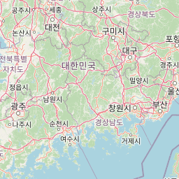
Map view of Mudeungsan National Park

Use this park location map to pinpoint Mudeungsan National Park in South Korea, understand its exact geographic position, and read its mapped placement within the surrounding landscape more clearly.

Pigeon | © OpenStreetMap contributors

Location context for Mudeungsan National Park

Jeollanam-do
Park atlas

Compare mountain parks and forest ecosystems across the Gwangju region and broader South Korea

Discover More National Parks Near Mudeungsan National Park: Explore Related Protected Landscapes
Browse additional national parks and protected areas geographically connected to Mudeungsan National Park, tracing a wider network of mountain landscapes and forest ecosystems across South Korea. Compare diverse conservation landscapes, understand regional protected-area distribution, and identify further exploration opportunities.
National parkSouth Korea

Naejangsan National Park: South Korea's Mapped Protected Landscape and Geography

Discover the park's protected boundaries and regional context.

Investigate Naejangsan National Park, a protected area within South Korea, through its mapped geography and landscape context. This detailed atlas entry provides insight into the park's specific geographic identity and its role as a national park, offering a structured understanding of its protected natural features for focused exploration and research.

Area
81.45 km²
Established
1971
IUCN
II
Relief
Mountain
National parkJeollanam-do

Wolchulsan National Park: Detailed Geographic and Protected Landscape Atlas Entry

Explore mapped boundaries and natural terrain context.

This MoriAtlas entry for Wolchulsan National Park provides a detailed look at its identity as a protected landscape within Jeollanam-do, South Korea. Focus is placed on its geographic context and mapped park boundaries, offering a foundation for understanding its place in the regional atlas. Discover the structured details of this national park's natural terrain and its significance as a preserved natural area.

Area
56.6 km²
Established
1988
IUCN
II
Relief
Mountain
National parkSouth Korea

Jirisan National Park: South Korea's Premier Protected Landscape and Map Resource

Explore the mapped terrain and protected area geography.

Jirisan National Park is a key protected area within South Korea, serving as a vital component of the nation's natural landscape. This atlas-focused content provides detailed geographic information, highlighting the park's mapped boundaries and its role within the regional context of the Korean Peninsula. Understand the distinct characteristics of this protected national park for comprehensive geographic discovery.

Area
471.75 km²
Established
1967
IUCN
II
Visitors
1.5M annual
National parkJeollabuk-do

Byeonsan-bando National Park: Protected Landscape and Geographic Context in Jeollabuk-do

Explore mapped terrain and regional park geography.

This detail page provides an in-depth look at Byeonsan-bando National Park, a protected area located in South Korea's Jeollabuk-do region. Users can discover the park's specific geographic identity, understand its mapped boundaries, and explore its role within the broader regional landscape. The content is structured for atlas exploration, offering detailed insights into the park's natural terrain and its significance as a national park.

Area
154.71 km²
Established
1988
IUCN
II
Relief
Mixed relief
National parkSouth Korea

Hallyeohaesang National Park: South Korea National Park Geographic Atlas Entry

Explore mapped protected area boundaries and natural terrain.

As a designated national park in South Korea, Hallyeohaesang National Park offers a distinct geographic profile crucial for atlas exploration. This entry focuses on its protected landscape features, mapped territorial extent, and regional context within the Republic of Korea. Understand the park's specific geographical markers and its significance as a mapped protected area.

Area
545.63 km²
Established
1968
IUCN
II
Access
Access unknown
National parkJeollabuk-do

Deogyusan National Park: National Park Identity and Geographic Mapping

Explore its protected land boundaries and regional landscape context.

Examine Deogyusan National Park, a designated national park situated in the Jeollabuk-do region of South Korea. This entry provides critical geographic context, focusing on the park's mapped boundaries and its role as a protected landscape. Users can gain a structured understanding of its natural terrain and regional significance, contributing to a broader atlas of protected areas.

Area
231.65 km²
Established
1975
IUCN
V
Visitors
1M annual
National parkSouth Korea

Dadohaehaesang National Park: Exploring South Korea's Coastal Protected Area Boundaries

Mapped landscape context and regional geography.

Delve into the protected landscape of Dadohaehaesang National Park, a significant national park located in South Korea. This entry provides critical geographic information, detailing the park's mapped boundaries and its place within the broader regional terrain. It serves as an essential resource for understanding the park's protected status and its unique natural features for those exploring national parks and protected areas within an atlas framework.

Area
2,321.5 km²
Established
1981
IUCN
II
Visitors
560K annual
National parkSouth Gyeongsang Province

Gayasan National Park: National Park Identity and Mapped Geographic Context in South Korea

Discover Protected Landscape and Regional Terrain

Gayasan National Park presents a distinct protected-area entity within South Gyeongsang Province, serving as a crucial point for atlas-driven geographic exploration. As a designated national park in South Korea, it offers insights into its specific mapped boundaries and the surrounding natural terrain. Understanding this park's role within the regional geography provides a foundational element for comprehending broader landscape patterns and protected land distribution across the country.

Area
167.6 km²
Established
1972
IUCN
II
Relief
Mountain

Common questions about visiting, size, designation, and location context for Mudeungsan National Park

Mudeungsan National Park FAQs for park facts, access, geography, and protected area context
Find quick answers about Mudeungsan National Park, including protected-area facts, park geography, trail and visitor context, and how the park fits into its surrounding country and regional landscape.
MoriAtlas Explorer

Continue Your Protected Areas Search Across the Global Atlas

Deepen your exploration by continuing the structured search for national parks and protected areas worldwide. Utilize the comprehensive filtering capabilities to compare different conservation landscapes and refine your understanding of global park geography. Discover more about the distribution and characteristics of protected natural areas.

Global natural geography