
Lakes
Park geography
A comprehensive analysis of recorded park boundaries, regional distribution, and natural elevation features.
Cerro Castillo National Park: Geographic Boundaries, Mountain Terrain, and Landscape Profile
This geographic profile examines the structured data of Cerro Castillo National Park, located within the Aysén del General Carlos Ibáñez del Campo Region of Chile. It covers the expanse of the protected landscape including mapped boundaries spanning over 1795 square kilometers, rugged mountain terrain, and specific natural features such as Cerro Castillo and Cascada de Seda.
Related tags
PatagoniaMountain ParksNational ParksHuemul ConservationSouthern Chile
Patagonian mountain reserve protecting the iconic Cerro Castillo peak and critical huemul habitat
Cerro Castillo National Park
Cerro Castillo National Park is a dramatic protected area in Chile's Aysén Region, encompassing 1,795.5 square kilometers of rugged Patagonian landscape. The park takes its name from Cerro Castillo, a striking granite mountain that serves as the park's central landmark and primary visual attraction. Located south of Coyhaique along the famous Carretera Austral, this park represents a vital corridor for wildlife movement through one of the world's most remote and ecologically significant regions. Originally established as a national reserve in 1970, the area was elevated to national park status in 2018 through a collaborative conservation agreement between the Chilean government and Tompkins Conservation, reflecting its growing importance in regional conservation strategies.
- Location
- Chile
- Park type
- National park
- Established
- 1970
- Area
- 1,795.5 km²
Location overview
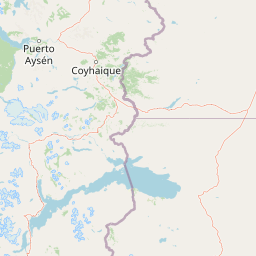
Map placement within the Aysén Region of continental Chile
Cerro Castillo National Park: Geographic Location and Regional Profile
Cerro Castillo National Park is situated within the Aysén del General Carlos Ibáñez del Campo Region of Chile. The continental land reserve includes no marine, island, coastal, or transboundary territories.
- Countries
- Chile
- Regions
- Aysén del General Carlos Ibáñez del Campo Region
- Primary location
- Aysén del General Carlos Ibáñez del Campo Region
- Geographic setting
- Inland
Boundary and coordinates
Mapping the 1795.5 square kilometer spatial footprint and regional limits
Boundary Map and Geographic Extent of Cerro Castillo National Park
Interactive boundary geometry outlines the spatial footprint of the park within its regional southern Andes setting. Accompanying geographic records detail the total area, perimeter estimations, center coordinates, and latitudinal span.
- Boundary area
- 1,432.1 km²
- Boundary perimeter
- 540 km
- Northernmost point
- 45.7706° S
- Southernmost point
- 46.2741° S
- Easternmost point
- 71.7294° W
- Westernmost point
- 72.544° W
- Geographic centre
- 46.0068° S, 72.1514° W
- North–south span
- 56 km
- East–west span
- 63.1 km
Terrain and natural features
Explore mountain terrain classifications and recorded landscape features
Cerro Castillo National Park Terrain and Named Natural Features
This protected area features a recorded mountain relief classification alongside multiple named peaks, lakes, and rivers located within the boundaries. Linked feature cards supply specific names, types, and spatial relationships for each mapped natural element.
Selected named natural features
Peaks
Cerro Castillo
2,675 m
Viewpoints
Mirador laguna Duff
Peaks
Cerro Ap Iwan
2,305 m
Peaks
Cerro Puntudo
2,216 m
Streams
Zanjón Feo
Environmental setting
Interpreting mountain relief, forest cover, and temperate habitats
Cerro Castillo National Park Environmental Classifications and Physical Setting
Recorded mountain relief, dominant forest cover, and temperate broadleaf habitats form complementary categories for reading the physical setting of Cerro Castillo National Park. Stored environmental properties connect specific classifications to related atlas destinations across regional terrain.
- Relief
- Mountain
- Water
- Minor water
- Forest cover
- Mostly forested
Landscape features
Mountains · Forest · Rivers
Habitat types
Temperate broadleaf forest
Park atlas
Browse the protected landscapes of Patagonian Chile, comparing geographic features and regional park connections.
Discover Other National Parks and Protected Areas Near Cerro Castillo, Southern Chile
Continue your exploration from Cerro Castillo National Park into adjacent protected areas across Chile's Aysén Region, revealing diverse Patagonian mountain and forest landscapes. Compare mapped park geography and conservation territories to understand the broader network of protected lands connected through this remote, ecologically significant region.
National parkAysén Region
34 km away#1 closest
South

Patagonia National Park, Chile: Exploring Protected Landscape and Regional Geography
Mapped boundaries and natural terrain in Aysén Region.
Patagonia National Park, situated within the Aysén Region of Chile, serves as a significant protected area offering rich opportunities for atlas-based geographic exploration. This national park's specific landscape identity and mapped boundaries provide a clear focal point for understanding regional conservation and natural terrain. Discover the geographic context of this protected land and its place within the broader landscape of southern Chile through structured data and map exploration.
- Area
- 3,045.28 km²
- Established
- 2018
- IUCN
- II
- Relief
- Mountain
National parkAysén del General Carlos Ibáñez del Campo Region
62 km away#2 closest
Southwest
Laguna San Rafael National Park: Explore its Mapped Boundaries and Patagonian Landscape
A National Park within Aysén del General Carlos Ibáñez del Campo Region.
Laguna San Rafael National Park stands as a key protected area within the vast geography of the Aysén del General Carlos Ibáñez del Campo Region. This entry provides an atlas-focused perspective, detailing the park's geographic significance, mapped natural landscapes, and its role as a vital conservation territory. Understand how this national park fits into the broader context of Patagonia's unique terrain and protected areas.
- Area
- 17,420 km²
- Established
- 1959
- IUCN
- II
- Relief
- Mountain
National parkArgentina
About 104 km away#3 closest
Southeast

Patagonia National Park: A National Park Protecting the Argentine Patagonian Steppe Landscape
Explore the mapped boundaries of this semi-arid grassland ecosystem.
Patagonia National Park is a protected national park in Argentina established to preserve the representative Patagonian steppe ecosystem. Covering 528.11 square kilometers, it offers a deep dive into the unique semi-arid grassland environment, known for its rolling plains and wind-shaped terrain. This park provides crucial context for understanding the broader geography of southern Argentina and the conservation of its distinctive natural landscapes.
- Area
- 528.11 km²
- Established
- 2015
- IUCN
- II
- Climate
- Arid
National parkAysén del General Carlos Ibáñez del Campo Region
111 km away#4 closest
Northwest
Isla Magdalena National Park: Protected Area and Regional Geography Context
Discover the mapped landscape of this national park.
Delve into the protected landscape of Isla Magdalena National Park, a key national park situated in the Aysén del General Carlos Ibáñez del Campo Region of Chile. This entry provides essential geographic context, focusing on the park's mapped boundaries and its role within the Patagonian environment. Understand its distinct identity as a protected area for structured atlas exploration.
- Area
- 1,576 km²
- Established
- 1983
- IUCN
- II
- Relief
- Mountain
National parkAysén del General Carlos Ibáñez del Campo Region
117 km away#5 closest
North
Queulat National Park: Patagonian Andes Glacier and Rainforest Discovery
Mapped protected area in Aysén del General Carlos Ibáñez del Campo Region.
Queulat National Park is a vast protected wilderness in southern Chile, renowned for its dramatic glacial alpine terrain and lush temperate rainforests. The park's geography is defined by steep glacial valleys, ice fields, and the iconic Queulat Hanging Glacier cascading from sheer cliffs. Discover the mapped boundaries of this significant Patagonian national park, offering unparalleled insight into its unique ecosystems and dramatic landscapes shaped by ice and forest.
- Area
- 1,541 km²
- Established
- 1983
- IUCN
- II
- Relief
- Mountain
Protected areaSanta Cruz Province
About 128 km away#6 closest
Southeast
Cueva de las Manos: Protected Area and Geological Landscapes in Santa Cruz Province
Archaeological mapping in the Pinturas River Canyon
Situated in the deep ravines of the Pinturas River Canyon, Cueva de las Manos is a primary protected area illustrating the intersection of prehistoric human activity and Patagonian geology. This site serves as a vital anchor for regional archaeology, featuring rock art layered across volcanic cliff walls that define the unique topography of northwestern Santa Cruz Province.
- Area
- 6 km²
- Established
- 1999
- Visitors
- 8K annual
- Relief
- Upland
National parkAysén Region
163 km away#7 closest
North
Melimoyu National Park: A Key Protected National Park within Chile's Aysén Region
Explore Melimoyu National Park's mapped boundaries and regional geography.
Melimoyu National Park stands as a distinct protected natural area, offering a focused lens for geographic discovery. As a national park situated in the Aysén Region, its mapped boundaries and regional landscape context are crucial for understanding its atlas significance. This entry provides specific details about the park's protected status and its contribution to the mapped terrain of southern Chile, enabling detailed exploration for atlas enthusiasts.
- Area
- 1,055 km²
- Established
- 2018
- IUCN
- II
- Relief
- Mixed relief
National parkArgentina
164 km away#8 closest
South
Perito Moreno National Park: Argentina's Expansive Patagonian Protected Landscape
Explore its mapped terrain and significant protected area geography.
Perito Moreno National Park stands as a cornerstone of Argentinian conservation, safeguarding over 126,000 hectares of striking Patagonian mountain wilderness. This national park protects a rare ecological transition zone, blending wet Andean forests with dry steppe environments across its dramatic amphitheater-like terrain and dual-watershed hydrography. Its mapped boundaries encompass significant natural geography, offering a clear atlas view of protected Patagonian landscapes.
- Area
- 1,268.3 km²
- Established
- 1937
- IUCN
- II
- Relief
- Mountain
MoriAtlas Explorer
Continue Exploring Cerro Castillo National Park's Geographic and Landscape Context
Dive deeper into the structured geographic data and mapped landscape details of Cerro Castillo National Park. Understand its role as a protected area, its dramatic terrain, and its place within the broader atlas of Chilean Patagonia. This exploration offers a factual, map-centric view of one of the region's most striking natural landmarks and its ecological significance.
Browse next
Global natural geography
Explore related park routes
Explore MoriAtlas Global ParksBrowse All MoriAtlas ParksGlobal Park Map DiscoveryMoriAtlas: Browse All CountriesBrowse All MoriAtlas ContinentsNational Park Environment AtlasGrand Canyon National Park AtlasYellowstone National Park AtlasYosemite National Park Atlas and GeographySerengeti National Park AtlasGalápagos National Park Protected LandscapeBanff National Park Geography and AtlasKruger National Park Atlas EntryUluṟu-Kata Tjuṯa National Park AtlasExplore Uluru-Kata Tjuta National Park GeographyPlitvice Lakes National Park AtlasFiordland National Park Protected LandscapeGreat Smoky Mountains National Park AtlasAfghanistan National Parks and Protected AreasAlbania National Parks and Protected AreasAlgeria National Parks and Protected AreasAmerican Samoa National Parks and Protected AreasAndorra National Parks and Protected AreasAngola National Parks and Protected AreasAntarctica National Parks and Protected AreasAntigua and Barbuda Park List