Mori Atlas logo
National parkPatagonia National Park

Discover the distinct semi-arid grassland ecosystems and wind-shaped terrain of this Argentine protected area.

Patagonia National Park National Park: Mapped Boundaries of the Patagonian Steppe

Patagonia National Park, located in Argentina's Santa Cruz Province, represents a critical protected national park dedicated to preserving the vast and unique Patagonian steppe ecosystem. Spanning 528.11 square kilometers, this park offers a profound insight into one of the world's most distinctive semi-arid grassland environments, characterized by rolling plains and wind-sculpted terrain. It serves as a vital component of regional conservation efforts, safeguarding the ecological and visual identity of Patagonia for atlas exploration and geographic understanding.

national parkPatagonian steppegrassland ecosystemSanta Cruz ProvinceArgentinaprotected area

Patagonia National Park

National park

Park overview

Structured park overview, official facts, and landscape profile for Patagonia National Park

Patagonia National Park park facts, protected area profile, and essential visitor context
Review the core facts for Patagonia National Park, including designation, size, terrain, visitor scale, habitats, and operating context in one park-focused overview.

About Patagonia National Park

Patagonia National Park represents Argentina's effort to protect a meaningful portion of the Patagonian steppe, a vast grassland ecosystem that defines much of southern Patagonia's ecological character. The park was established in 2015, making it one of Argentina's more recently designated national parks, and it occupies a strategic position within the Santa Cruz Province. The protection of this area reflects growing recognition of the Patagonian steppe's ecological significance, as the ecosystem has been subject to various pressures from agricultural expansion, ranching activities, and infrastructure development across its range. The park's establishment also represents a continuation of Argentina's national park system, which began with the creation of Nahuel Huapi National Park in 1934 and has grown to encompass diverse ecosystems from the subtropical forests of the northeast to the glacial landscapes of the far south. The park's contiguous relationship with the Patagonia Wilderness Nature Reserve, added in 2018, creates a larger conservation complex that enhances habitat connectivity and ecological resilience for the region's native species.

Quick facts and research context for Patagonia National Park

Patagonia National Park is located in the Santa Cruz Province of southern Argentina, at coordinates approximately 47°16′S 71°32′W. The park was established in 2015 and covers 528.11 square kilometers of Patagonian steppe terrain. It holds IUCN Category II designation as a national park and is managed by Argentina's National Parks Administration. The adjacent Patagonia Wilderness Nature Reserve adds 387.87 square kilometers of additional protected area to the north and east, creating a consolidated conservation landscape within the Patagonian region.

Park context

Deeper park guide and search-rich context for Patagonia National Park

Patagonia National Park history, landscape, wildlife, and travel context
Explore Patagonia National Park through its history, landscape character, ecosystems, wildlife, conservation priorities, cultural context, and seasonal travel timing in a structured park guide built for atlas discovery and search intent.

Why Patagonia National Park stands out

Patagonia National Park is best known for its protection of the Patagonian steppe, one of South America's most distinctive and ecologically significant grassland ecosystems. The park preserves the characteristic landscapes of this semi-arid region, featuring rolling plains, scrubland vegetation, and the dramatic, wind-shaped terrain that defines much of Patagonia's visual identity. The steppe ecosystem supports a unique assemblage of adapted species and represents a increasingly rare habitat type that faces pressure from grazing, development, and climate change across its range.

Patagonia National Park history and protected-area timeline

Patagonia National Park was designated in 2015 by the government of Argentina as part of efforts to expand protected area coverage in the Patagonian region. The creation of the park reflected growing recognition of the need to preserve the Patagonian steppe ecosystem, which had historically received less protection than other Argentine environments such as the Andes and the Iguazu region. The subsequent designation of the Patagonia Wilderness Nature Reserve in 2018 further expanded the protected area complex to the north and east, creating a more comprehensive conservation unit within the Patagonian landscape. The park is administered by Argentina's National Parks Administration, the federal agency responsible for managing the nation's protected areas and implementing conservation policy.

Patagonia National Park landscape and geographic character

The landscape of Patagonia National Park is defined by the Patagonian steppe, a vast semi-arid grassland ecosystem characterized by gently rolling plains, open plains, and exposed terrain shaped by centuries of wind and weather. The terrain features the distinctive wind-caressed appearance that is synonymous with Patagonia, where vegetation grows low and sparse in response to the harsh, dry conditions. The landscape lacks the dramatic mountain peaks found in other Patagonian protected areas, instead offering the more subtle but equally compelling beauty of the open steppe, where the horizon stretches endlessly across the terrain. The vegetation is dominated by grasses, shrubs, and cushion plants adapted to the region's arid climate, creating a tapestry of textures and tones across the landscape.

Patagonia National Park ecosystems, habitats, and plant life

The Patagonian steppe is a distinctive ecological formation that represents one of the world's major grassland biomes. This semi-arid environment supports a specialized community of plants and animals adapted to drought, strong winds, and temperature extremes. The vegetation is characterized by bunch grasses, thorny shrubs, and steppe herbs that have evolved to survive in conditions where water is scarce and the growing season is short. The ecosystem represents a globally significant habitat type that is largely endemic to southern South America and is found almost exclusively within Argentina and Chile. The steppe supports a limited but distinctive group of species that have evolved to exploit the resources available in this challenging environment.

Patagonia National Park wildlife and species highlights

The Patagonian steppe supports a specialized fauna adapted to the harsh conditions of this semi-arid grassland. Mammals typical of the region include guanacos, the wild ancestor of the domestic llama, which roam the steppe in small herds, as well as smaller mammals such as viscachas, armadillos, and various rodent species. The birdlife of the steppe includes species such as the greater rhea, South America's largest bird, as well as various birds of prey, parrots, and songbirds that have adapted to the open grassland environment. The region's relative ecological simplicity means that wildlife viewing opportunities, while more subtle than in tropical environments, offer a genuine connection to one of the world's least-modified grassland ecosystems.

Patagonia National Park conservation status and protection priorities

Patagonia National Park plays an important role in protecting one of South America's most distinctive and threatened grassland ecosystems. The Patagonian steppe has faced significant pressure from overgrazing by sheep and cattle, agricultural expansion, and infrastructure development, leading to habitat degradation across much of its historical range. The establishment of the park and the adjacent wilderness reserve creates protected areas where the steppe ecosystem can function with minimal human interference, allowing natural processes to continue and providing refuge for native species. The park's IUCN Category II designation reflects its primary objective of protecting natural ecosystems while also providing opportunities for scientific research, environmental education, and sustainable recreation.

Patagonia National Park cultural meaning and human context

The Patagonian steppe has been inhabited by human communities for thousands of years, with indigenous peoples such as the Tehuelche having historically occupied these lands before European colonization. The region later became associated with the legendary gaucho culture of the Argentine plains, and the area's ranching tradition continues to shape the landscape and cultural identity of the Santa Cruz Province. While the park itself does not contain major archaeological sites or extensive cultural heritage features, the broader Patagonian region carries significant cultural meaning related to the history of indigenous peoples, the cowboy traditions of the Argentine plains, and the later waves of European immigration that contributed to the region's development.

Top sights and standout views in Patagonia National Park

The primary highlight of Patagonia National Park is its protection of the Patagonian steppe, a globally significant grassland ecosystem that is increasingly rare and threatened across its range. Visitors to the park can experience the distinctive character of the Patagonian landscape, with its expansive views, wind-sculpted vegetation, and the sense of remoteness that defines much of this region. The park offers opportunities to observe native wildlife including guanacos, greater rheas, and various bird species in a relatively undisturbed setting. The proximity to the Patagonia Wilderness Nature Reserve creates the possibility for extended exploration of a larger protected landscape. The park's relative newness and the ongoing development of visitor infrastructure also mean that the area retains a sense of discovery and wildness that is increasingly valued in an era of heavy tourism pressure on more established protected areas.

Best time to visit Patagonia National Park

The Patagonian steppe can be visited throughout the year, though the region's climate is characterized by strong winds, cold temperatures, and significant variation between seasons. The summer months of December through February bring warmer conditions and longer daylight hours, making this the most popular time for visitors. Winter months offer a different experience, with the landscape potentially covered in snow and fewer visitors, though access and conditions may be more challenging. The shoulder seasons of spring and autumn provide intermediate conditions and may offer a balance between favorable weather and fewer crowds. Visitors should be prepared for the unpredictable nature of Patagonian weather, where conditions can change rapidly and the wind can be a significant factor regardless of the season.

Park location guide

Geography guide, regional context, and park location map for Patagonia National Park

Patagonia National Park park geography, regions, and map view in Argentina
Understand where Patagonia National Park sits in Argentina through a broader geographic reading of the surrounding landscape, nearby location context, and its mapped position within the national park landscape.

How Patagonia National Park fits into Argentina

Argentina is a federal republic located in the southern cone of South America, bordering Chile, Bolivia, Paraguay, Brazil, Uruguay, and the Atlantic Ocean. With an area of 2,780,085 km², it is the second-largest country in South America and the eighth-largest globally. The capital and largest city is Buenos Aires, and the official language is Spanish. The country claims sovereignty over the Falkland Islands, South Georgia and the South Sandwich Islands, and a portion of Antarctica.

Wider geography shaping Patagonia National Park in Argentina

Argentina occupies the southern portion of South America, sharing the Southern Cone region with Chile to the west. The country borders Bolivia and Paraguay to the north, Brazil to the northeast, Uruguay and the South Atlantic Ocean to the east, and the Drake Passage to the south. The Andes mountain range runs along the western border, while the Pampas plains dominate the central region. Argentina also claims territories in Antarctica.

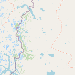
Map view of Patagonia National Park

Use this park location map to pinpoint Patagonia National Park in Argentina, understand its exact geographic position, and read its mapped placement within the surrounding landscape more clearly.

Pigeon | © OpenStreetMap contributors
Park atlas

Compare the diverse protected landscapes and vital conservation areas in the broader Patagonian region

Explore Related National Parks and Protected Landscapes Near Patagonia National Park
Browse other national parks and protected areas across Argentina's Santa Cruz Province and the surrounding Patagonian region. Compare their unique protected landscapes, distinct steppe ecosystems, and geographic context to expand your understanding of regional conservation efforts.
National parkAysén Region

Patagonia National Park, Chile: Exploring Protected Landscape and Regional Geography

Mapped boundaries and natural terrain in Aysén Region.

Patagonia National Park, situated within the Aysén Region of Chile, serves as a significant protected area offering rich opportunities for atlas-based geographic exploration. This national park's specific landscape identity and mapped boundaries provide a clear focal point for understanding regional conservation and natural terrain. Discover the geographic context of this protected land and its place within the broader landscape of southern Chile through structured data and map exploration.

Area
3,045.28 km²
Established
2018
IUCN
II
Relief
Mountain
National park

Perito Moreno National Park: Argentina's Expansive Patagonian Protected Landscape

Explore its mapped terrain and significant protected area geography.

Perito Moreno National Park stands as a cornerstone of Argentinian conservation, safeguarding over 126,000 hectares of striking Patagonian mountain wilderness. This national park protects a rare ecological transition zone, blending wet Andean forests with dry steppe environments across its dramatic amphitheater-like terrain and dual-watershed hydrography. Its mapped boundaries encompass significant natural geography, offering a clear atlas view of protected Patagonian landscapes.

Area
1,268.3 km²
Established
1937
IUCN
II
Relief
Mountain
National parkAysén del General Carlos Ibáñez del Campo Region

Cerro Castillo National Park: Dramatic Granite Peaks and Patagonian Protected Landscape

Mapped geography and huemul conservation in Chile's Aysén Region.

Cerro Castillo National Park is a premier protected area in southern Chile, celebrated for its iconic Cerro Castillo granite mountain that dominates the landscape. This national park, spanning over 1,700 square kilometers in the Aysén del General Carlos Ibáñez del Campo Region, showcases a dynamic Patagonian terrain shaped by glaciers and rivers. Its significance extends to being a vital corridor for endangered huemul, offering critical habitat within a broader regional conservation strategy and the famous Route of Parks.

Area
1,795.5 km²
Established
1970
IUCN
II
Relief
Mountain
National parkAysén del General Carlos Ibáñez del Campo Region

Laguna San Rafael National Park: Explore its Mapped Boundaries and Patagonian Landscape

A National Park within Aysén del General Carlos Ibáñez del Campo Region.

Laguna San Rafael National Park stands as a key protected area within the vast geography of the Aysén del General Carlos Ibáñez del Campo Region. This entry provides an atlas-focused perspective, detailing the park's geographic significance, mapped natural landscapes, and its role as a vital conservation territory. Understand how this national park fits into the broader context of Patagonia's unique terrain and protected areas.

Area
17,420 km²
Established
1959
IUCN
II
Relief
Mountain
National park

Bosques Petrificados de Jaramillo National Park: Argentina's Jurassic Petrified Forest Landscape

Explore mapped fossil trees across the Patagonian steppe.

Bosques Petrificados de Jaramillo National Park is a protected national park in Argentina's Santa Cruz Province, celebrated for its extensive collection of Jurassic period fossilized trees. Spanning nearly 80,000 hectares of Patagonian steppe, the park's unique landscape is defined by exposed petrified trunks, some of remarkable size, providing crucial evidence of the region's ancient ecosystems and paleoclimatic history. Discover this extraordinary site through its mapped geography and protected landscape identity.

Area
785.43 km²
Established
2012
IUCN
II
Relief
Mixed relief
National parkAysén del General Carlos Ibáñez del Campo Region

Isla Magdalena National Park: Protected Area and Regional Geography Context

Discover the mapped landscape of this national park.

Delve into the protected landscape of Isla Magdalena National Park, a key national park situated in the Aysén del General Carlos Ibáñez del Campo Region of Chile. This entry provides essential geographic context, focusing on the park's mapped boundaries and its role within the Patagonian environment. Understand its distinct identity as a protected area for structured atlas exploration.

Area
1,576 km²
Established
1983
IUCN
II
Relief
Mountain
Watercolor illustration of rolling hills, a river flowing through a valley, and forested areas
National parkAysén del General Carlos Ibáñez del Campo Region

Queulat National Park: Patagonian Andes Glacier and Rainforest Discovery

Mapped protected area in Aysén del General Carlos Ibáñez del Campo Region.

Queulat National Park is a vast protected wilderness in southern Chile, renowned for its dramatic glacial alpine terrain and lush temperate rainforests. The park's geography is defined by steep glacial valleys, ice fields, and the iconic Queulat Hanging Glacier cascading from sheer cliffs. Discover the mapped boundaries of this significant Patagonian national park, offering unparalleled insight into its unique ecosystems and dramatic landscapes shaped by ice and forest.

Area
1,541 km²
Established
1983
IUCN
II
Relief
Mountain
National park

Los Glaciares National Park: Argentinian National Park with Patagonian Ice Fields

Explore glacial terrain and iconic Andes peaks.

Los Glaciares National Park is a vast protected area in Argentina, dominated by a massive Patagonian ice cap and numerous descending glaciers, including the renowned Perito Moreno Glacier. Its dramatic landscape of ice fields, glacial lakes, and towering granite spires like Mount Fitz Roy provides critical context for understanding regional geography and the formation of glacial terrain. This park exemplifies the unique protected ecosystems of the southern Andes, offering rich detail for atlas-based discovery.

Area
7,269.27 km²
Established
1937
IUCN
II
Visitors
688.8K annual

Common questions about visiting, size, designation, and location context for Patagonia National Park

Patagonia National Park FAQs for park facts, access, geography, and protected area context
Find quick answers about Patagonia National Park, including protected-area facts, park geography, trail and visitor context, and how the park fits into its surrounding country and regional landscape.
MoriAtlas Explorer

Continue Your Protected Areas Search Across the Global Atlas

Deepen your exploration by continuing the structured search for national parks and protected areas worldwide. Utilize the comprehensive filtering capabilities to compare different conservation landscapes and refine your understanding of global park geography. Discover more about the distribution and characteristics of protected natural areas.

Global natural geography