

Mori Atlas logo
Wildlife reserveChumbi Surla Wildlife Sanctuary

Understanding the mapped terrain, scrub forest habitats, and regional conservation status

Chumbi Surla Wildlife Sanctuary: A Core Protected Wildlife Reserve in the Punjab Foothills

Chumbi Surla Wildlife Sanctuary serves as a significant protected block of dry subtropical forest and hill terrain within the Punjab region of Pakistan. Spanning across the Khushab and Chakwal Districts, the sanctuary preserves rugged foothill landscapes and essential habitat for the Punjab urial. This area functions as a contiguous refuge, protecting broken ridges and ravine systems that remain vital for regional biodiversity and wildlife conservation.

wildlife sanctuaryPunjab Pakistandry subtropical forestscrub biomefoothill habitaturial conservation

Chumbi Surla Wildlife Sanctuary

Wildlife reserve

Park overview

Structured park overview, official facts, and landscape profile for Chumbi Surla Wildlife Sanctuary

Chumbi Surla Wildlife Sanctuary park facts, protected area profile, and essential visitor context

Review the core facts for Chumbi Surla Wildlife Sanctuary, including designation, size, terrain, visitor scale, habitats, and operating context in one park-focused overview.

About Chumbi Surla Wildlife Sanctuary

Chumbi Surla Wildlife Sanctuary occupies a substantial block of foothill terrain in the Punjab province of Pakistan, stretching across the districts of Khushab and Chakwal. The sanctuary was designated in 1978 under the management of the Wildlife and Parks Department, Government of Punjab, and is classified internationally as an IUCN Category IV protected area, a designation typically used for habitats managed specifically for the conservation of particular species or habitat communities rather than for broad ecosystem protection.

The landscape is shaped by the kind of broken, scrub-covered hills and reserve forest typical of the Salt Range and its southern extensions. Elevations across the sanctuary rise from roughly 460 metres to about 1,050 metres above sea level, creating a mosaic of valleys, ridges, and stony outcrops. Climate conditions across the area are strongly seasonal, with air temperatures ranging from about 10°C in cooler months to around 40°C at the height of summer, and rainfall patterns that support dry subtropical vegetation rather than moist forest.

Vegetation across the sanctuary is dominated by dry subtropical evergreen scrub and forest, characteristic of the lower-middle elevations of Punjab's hill country. This habitat is closely tied to the survival of the urial, which depends on steep, broken, lightly disturbed terrain with reliable forage and escape cover. By encompassing a continuous tract of such habitat across two districts, Chumbi Surla provides one of the larger blocks of available urial range in the region.

For visitors and researchers, Chumbi Surla represents an example of species-focused conservation in a heavily populated agricultural landscape. Where many of Punjab's original foothill forests have been converted to cultivation or grazing, the sanctuary still retains connected reserve forest, making it functionally important not only for the urial but for the broader scrubland wildlife community that shares its habitat.

Quick facts and research context for Chumbi Surla Wildlife Sanctuary

Chumbi Surla Wildlife Sanctuary lies in the foothills of Punjab, Pakistan, straddling both Khushab District and Chakwal District. Designated an IUCN Category IV habitat and species management area, it covers roughly 56,000 acres of reserve forest and hill country.

Established in 1978, the sanctuary exists principally to protect the threatened Punjab urial alongside other regional wildlife. Its dry subtropical evergreen vegetation, scrub biome, and elevations up to about 1,050 metres define its ecological character. The sanctuary is administered by the Wildlife and Parks Department of the Government of Punjab.

Protection and recognition

Examining documented terrestrial conservation parameters and formal recognition records

Chumbi Surla Wildlife Sanctuary Protection Status and Administrative Scope

Chumbi Surla Wildlife Sanctuary maintains a defined terrestrial protection profile within global conservation databases. Verified administrative records outline the official status and baseline designation metrics associated with the protected landscape.

Protection details

Protection scope
Terrestrial
WDPA ID
6690
Park context

Deeper park guide and search-rich context for Chumbi Surla Wildlife Sanctuary

Chumbi Surla Wildlife Sanctuary history, landscape, wildlife, and travel context

Explore Chumbi Surla Wildlife Sanctuary through its history, landscape character, ecosystems, wildlife, conservation priorities, cultural context, and seasonal travel timing in a structured park guide built for atlas discovery and search intent.

Why Chumbi Surla Wildlife Sanctuary stands out

Chumbi Surla is best known as a dedicated refuge for the threatened Punjab urial, a wild sheep native to the foothill ranges of northern Punjab. The sanctuary was created in 1978 specifically around the conservation needs of this species, which has suffered considerable range contraction across much of its former habitat. Beyond the urial, the reserve is recognised for safeguarding an unusually large block of dry subtropical scrub forest and hill habitat within otherwise heavily used agricultural and grazing landscapes. The combination of contiguous reserve forest, broken hill terrain, and elevation variation gives the sanctuary value both as a wildlife refuge and as a representative example of Punjab's foothill ecosystems.

Chumbi Surla Wildlife Sanctuary history and protected-area timeline

Chumbi Surla Wildlife Sanctuary was formally established in 1978 by the Government of Punjab under what is now the Wildlife and Parks Department. Its creation reflects a period in which Pakistan was formalising protected-area networks around key wildlife habitats, particularly for species that had come under pressure from hunting, habitat loss, and competition with livestock.

The sanctuary's founding purpose was the conservation of the threatened Punjab urial, alongside several other wildlife species native to the region's foothill hills and scrub forests. By placing a large block of reserve forest and hill terrain under legal protection, the government sought to create a stable refuge where urial populations and associated scrubland species could persist in the face of agricultural expansion in surrounding districts. Over the decades since its designation, the sanctuary has continued to function as a species-focussed protected area under IUCN Category IV classification, with management oriented toward habitat and species management rather than strict wilderness preservation.

Chumbi Surla Wildlife Sanctuary landscape and geographic character

The sanctuary's terrain consists of low to mid-elevation hills intersected by valleys, ravines, and stony slopes, forming a classic foothill landscape of the kind found across the Salt Range and its outliers. Elevations range from roughly 460 metres near the lower valleys up to about 1,050 metres on the higher ridges, producing a varied topography within the protected boundary.

Reserve forest covers much of the area, with continuous tracts of woodland and scrub extending across both Khushab and Chakwal Districts. The combination of bedrock ridges, thin soils, and patchy tree cover creates the kind of mosaic that supports both browsing wildlife and ground-dwelling species. Outside the sanctuary, similar terrain has often been converted to farmland or heavily grazed, making Chumbi Surla's unbroken hill cover especially significant at the regional scale.

Chumbi Surla Wildlife Sanctuary ecosystems, habitats, and plant life

Ecologically, Chumbi Surla belongs to the dry subtropical evergreen vegetation zone that characterises much of central and northern Punjab's hill country. The principal biome is scrub, comprising thorny and drought-tolerant shrub species along with hardy evergreen trees able to cope with the area's strong seasonal climate.

Because the sanctuary encompasses a continuous block of reserve forest rather than a patchwork of fragmented patches, the vegetation retains ecological coherence. Dry subtropical evergreen plant communities here typically include a mix of acacia, olive, and other broad-leaved evergreen species adapted to shallow soils and prolonged dry periods. Annual rainfall, while variable, is sufficient to maintain closed-canopy scrub forest in sheltered valleys, while exposed ridges carry a more open, shrub-dominated cover.

The interaction between elevation, soil depth, and exposure produces distinct habitat layers within the sanctuary. Lower slopes tend to support denser, taller scrub and small tree patches, while upper ridges carry thinner, more open vegetation suited to species adapted to wind and sun exposure. This layering creates a variety of ecological niches within a relatively compact protected area.

Chumbi Surla Wildlife Sanctuary wildlife and species highlights

The signature species of Chumbi Surla Wildlife Sanctuary is the Punjab urial, a wild sheep native to the foothill ranges of northern Punjab and surrounding regions. The sanctuary was established specifically to safeguard urial populations that had declined elsewhere due to habitat loss, hunting pressure, and competition with livestock. The rough, broken hills and scrub cover of Chumbi Surla provide the kind of escape terrain and seasonal forage that urials need to persist.

Beyond the urial, the sanctuary's dry subtropical scrub and reserve forest are known to support a broader community of native wildlife characteristic of Punjab's lower hill ranges. Mammalian fauna documented in surveys of the area includes species adapted to scrub, rocky slopes, and seasonal browse. The combination of continuous forest cover, water availability along drainage lines, and varied topography helps sustain both resident species and those that move through the wider landscape between protected and non-protected areas.

Birdlife in Chumbi Surla reflects the broader avifauna of dry subtropical and semiarid habitats, with scrub specialists and raptor species drawn to the mix of open ridges and sheltered wooded valleys. For researchers and conservation groups, the sanctuary therefore represents a coherent block of habitat supporting both an iconic ungulate and the wider scrubland fauna typical of the region.

Chumbi Surla Wildlife Sanctuary conservation status and protection priorities

From a conservation standpoint, Chumbi Surla's significance lies in combining a relatively large protected footprint with a clear species-focussed mandate. Classified internationally as an IUCN Category IV habitat and species management area, the sanctuary is managed primarily to maintain conditions favourable for the urial and other native wildlife rather than to preserve a wilderness character in the strictest sense.

The surrounding region of Punjab has experienced extensive conversion of natural vegetation to cropland, orchards, and grazing land, leaving only scattered patches of original foothill habitat. By encompassing a continuous area of reserve forest and hill terrain across two districts, Chumbi Surla preserves habitat connectivity and ecological function at a landscape scale that smaller, fragmented reserves cannot match.

The sanctuary is administered by the Wildlife and Parks Department, Government of Punjab, which oversees habitat management, anti-poaching efforts, and broader wildlife policy in the province. Continued protection of Chumbi Surla is considered important not only for the survival of the urial in central Punjab but also for maintaining a representative example of dry subtropical scrub habitat under formal protection, against a backdrop of ongoing pressure on wild lands across the province.

Chumbi Surla Wildlife Sanctuary cultural meaning and human context

Chumbi Surla lies in a region where rural communities have long interacted with the foothill landscape through subsistence agriculture, livestock grazing, and traditional use of forest products. The hills and scrub forests around the present sanctuary have historically supported local livelihoods, including grazing by goats and sheep whose pressure on wild vegetation has shaped habitat conditions over centuries.

The urial itself has a long-standing place in the regional natural and cultural landscape of Punjab's hill country. Local communities have historically encountered these wild sheep in the surrounding ranges, and the species features in regional ecological and cultural narratives tied to the Salt Range and surrounding districts. The sanctuary's establishment in 1978 marked a shift toward formal wildlife protection in an area where land use had otherwise been primarily oriented toward agriculture and pastoral activity.

Top sights and standout views in Chumbi Surla Wildlife Sanctuary

Chumbi Surla Wildlife Sanctuary stands out for its sheer scale among Punjab's foothill reserves, covering roughly 55,945 acres of continuous reserve forest and hill habitat across both Khushab and Chakwal Districts. This contiguous footprint is itself a conservation highlight, given how fragmented similar habitats have become elsewhere in the province.

The sanctuary's defining feature is its role as a stronghold for the Punjab urial, supported by the dry subtropical evergreen vegetation and broken hill terrain that the reserve was created to protect. Together with its IUCN Category IV designation and administration by the Wildlife and Parks Department of Punjab, these qualities place Chumbi Surla among the more important species-focussed protected areas in northern Punjab.

Best time to visit Chumbi Surla Wildlife Sanctuary

The climate of Chumbi Surla is strongly seasonal, with cool winters and hot summers, and the character of a visit changes accordingly. Cooler months, generally running from late autumn through early spring, tend to bring milder temperatures and more comfortable conditions for moving through the scrub and hill terrain, and are often associated with wildlife being more active in lower valleys.

Hotter months push temperatures towards the upper end of the recorded range, with conditions that can be harsh for both visitors and wildlife on exposed ridges. Rainfall events influence vegetation condition and the visibility of animal tracks and movement within the sanctuary. In general, periods with moderate temperatures and clear visibility tend to provide the most favourable conditions for exploring the sanctuary's hill scenery and observing its wildlife.
Monthly climate preview

Long-term temperature ranges and monthly precipitation distributions for Chumbi Surla Wildlife Sanctuary

Chumbi Surla Wildlife Sanctuary Climate Normals and Annual Weather Patterns

Representative coordinates record annual temperature progression alongside monthly precipitation variation across the protected landscape. Detailed twelve-month climate normals provide a complete statistical record for comparative geographical analysis.
Annual mean24 °C
11 °C36 °C
Jan11°
Feb14°
Mar20°
Apr26°
May32°
Jun36°
Jul34°
Aug32°
Sep30°
Oct25°
Nov19°
Dec14°
Warmest month
June

35.6 °C

Coolest month
January

11.2 °C

Wettest month
July

3.8 mm/day

Driest month
November

0.3 mm/day

Park location guide

Geography guide, regional context, and park location map for Chumbi Surla Wildlife Sanctuary

Chumbi Surla Wildlife Sanctuary park geography, regions, and map view in Pakistan

Understand where Chumbi Surla Wildlife Sanctuary sits in Pakistan through a broader geographic reading of the surrounding landscape, nearby location context, and its mapped position within the national park landscape.

How Chumbi Surla Wildlife Sanctuary fits into Pakistan

Pakistan, officially the Islamic Republic of Pakistan, is a federal parliamentary Islamic republic in South Asia. It is the fifth-most populous country and the 33rd-largest by area. The country gained independence from British India in 1947 and has a diverse history spanning ancient civilizations including Mehrgarh and the Indus Valley Civilisation. Pakistan shares maritime borders with Oman and is bounded by the Arabian Sea, Gulf of Oman, and several neighboring countries.

Wider geography shaping Chumbi Surla Wildlife Sanctuary in Pakistan

Pakistan is located in South Asia, bordered by the Arabian Sea to the south, the Gulf of Oman to the southwest, and shares land borders with India to the east, Afghanistan to the west, Iran to the southwest, and China to the northeast. The country also shares a maritime border with Oman in the Gulf of Oman. The Wakhan Corridor in Afghanistan separates Pakistan from Tajikistan in the northwest.

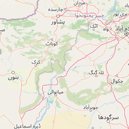
Map view of Chumbi Surla Wildlife Sanctuary

Use this park location map to pinpoint Chumbi Surla Wildlife Sanctuary in Pakistan, understand its exact geographic position, and read its mapped placement within the surrounding landscape more clearly.

Pigeon | © OpenStreetMap contributors

Location context for Chumbi Surla Wildlife Sanctuary

Punjab
Park atlas

Compare regional protected areas and connected dry subtropical forest landscapes.

Parks Near Chumbi Surla Wildlife Sanctuary and Surrounding Foothill Reserves

Browse other protected areas and foothill reserves situated near Chumbi Surla Wildlife Sanctuary across the northern Punjab region. Comparing adjacent natural habitats provides broader geographic context for regional conservation landscapes and wildlife corridors.
A wide watercolor illustration showing a calm body of water in the foreground, green trees and reeds along the shoreline, and soft rolling hills in the background under a pale sky
Protected areaKhushab District
About 32 km away#1 closest

West

Uchhali Complex Protected Area: Geography, Salt Range Lakes, and Wetland Mapping

Key protected wetland landscape in the Soon Valley of Punjab

The Uchhali Complex serves as a critical wetland system characterized by the brackish and saline waters of Khabikki, Uchhali, and Jahlar lakes. Situated in the Soon Valley, this protected area offers a unique geographic perspective on the interplay between the mineralized geology of the Salt Range and the surrounding semi-arid terrain. This detail overview examines the site as a landmark habitat for migratory waterbirds and a defining feature of the Khushab District landscape.

Area
12.43 km²
Established
1996
Access
Access unknown
Scope
Terrestrial
National parkPunjab
About 41 km away#2 closest

North

Chinji National Park: National Park Atlas, Salt Range Geography, and Protected Landscape

Discover the unique eroded terrain and semi-arid ecosystems of Punjab, Pakistan.

Chinji National Park is a protected national park located in the Punjab province of Pakistan, specifically within the historic Salt Range. This park is characterized by its deeply eroded terrain, composed of sandstone and igneous rock formations, shaped by seasonal streams that lead towards the Soan River. As a key example of a semi-arid mountain ecosystem within the Baluchistan xeric woodlands ecoregion, Chinji National Park offers significant insights into the geological heritage and unique biodiversity of central Pakistan.

Area
60.95 km²
Established
1987
IUCN
II
Relief
Upland
National parkPakistan
About 43 km away#3 closest

East

Salt Range National Park: Pakistan's Protected Landscape for Geographic Atlas Exploration

Mapped boundaries and regional terrain context for a Pakistani national park.

Gain insight into Salt Range National Park, a significant national park established within Pakistan. This entry focuses on its role as a protected landscape, providing a mapped view of its geographic scope and environmental context. Understand how this park contributes to Pakistan's broader geography and offers opportunities for atlas-based discovery of its natural terrain.

Relief
Mountain
Scope
Terrestrial
National parkJhelum District
About 78 km away#4 closest

East

Tilla Reserve National Park: Mapped Protected Landscape and Dry Forest Ecosystem

Explore the geography and ancient heritage of this Salt Range national park.

Tilla Reserve National Park is a protected area recognized for its significant dry subtropical forest ecosystems and rich cultural history within Pakistan's Salt Range. Situated in Jhelum District, the park's landscape is characterized by steep, rocky ridges and ancient geological formations. Discover its unique mapped terrain, the distribution of its remnant forest habitats, and its importance as a protected natural and spiritual site.

Area
40.6 km²
Established
2021
IUCN
II
Relief
Mountain
National parkPunjab
About 99 km away#5 closest

Northeast

Kheri Murat National Park: Protected Scrub Forest and Wildlife Conservation in Punjab

Explore the mapped terrain and protected landscape context.

Discover Kheri Murat National Park, a recent national park designation located in Punjab, Pakistan, situated on the rolling hills of the Kala Chitta Range. This protected area features a distinct subtropical thorn scrub forest ecosystem, providing essential habitat for wildlife, including the Punjab urial, and serving as a critical site for bird conservation. Its unique landscape offers valuable insights into regional geography and the preservation of natural wilderness within a predominantly agricultural province, making it a noteworthy entity for atlas exploration.

Area
35.37 km²
Established
2020
IUCN
II
Relief
Mountain
National parkAttock District
About 110 km away#6 closest

North

Kala Chitta National Park: Protected Dry Temperate Forest in Attock District, Pakistan

Discover unique hill landscapes and a rare ecosystem on the Pothohar Plateau.

Kala Chitta National Park represents a crucial protected area in Punjab, Pakistan, safeguarding a distinct dry temperate forest ecosystem that is uncommon in the Pothohar Plateau's heavily agricultural landscape. The park's terrain comprises rolling hills and intervening plains, contributing to its ecological richness and providing valuable mapped landscape context. Explore the geographic importance of this national park and its role in preserving a vital natural habitat.

Area
363.77 km²
Established
1983
IUCN
II
Relief
Mixed relief
National parkIslamabad Capital Territory
About 129 km away#7 closest

Northeast

Margalla Hills National Park: Pakistan's Gateway to Himalayan Foothills Geography

Mapped protected landscape with rich Sino-Himalayan biodiversity.

Margalla Hills National Park, situated in the Islamabad Capital Territory, serves as Pakistan's most accessible national park and a vital entry point to the Himalayan foothills. This protected landscape is defined by its rugged mountain terrain, ranging from lower scrublands to higher pine and oak woodlands, with elevations up to 1,604 meters. The park's geological significance, with ancient marine fossil formations, adds a unique dimension to its natural identity. Discover the mapped boundaries and ecological richness that characterize this important protected area, offering insights into regional geography and diverse habitats.

Area
173.86 km²
Established
1980
IUCN
V
Relief
Mountain
Protected areaKhyber Pakhtunkhwa
About 132 km away#8 closest

Northwest

Tanda Dam Protected Area: Geographic Context and Wetland Map Features in Khyber Pakhtunkhwa

Ramsar-listed reservoir and regional irrigation landscape

Tanda Dam is a critical irrigation reservoir and Ramsar-listed wetland located in the Kohat District. This protected area supports agricultural networks for surrounding villages while serving as a winter refuge for migratory waterbirds traveling from the Caspian region and Siberia. The site offers a unique perspective on managed water landscapes within the broader terrain of Khyber Pakhtunkhwa.

Area
4.05 km²
Established
1967
Relief
Lowland
Scope
Terrestrial

Common questions about visiting, size, designation, and location context for Chumbi Surla Wildlife Sanctuary

Chumbi Surla Wildlife Sanctuary FAQs for park facts, access, geography, and protected area context

Find quick answers about Chumbi Surla Wildlife Sanctuary, including protected-area facts, park geography, trail and visitor context, and how the park fits into its surrounding country and regional landscape.
MoriAtlas Explorer

Continue Your Protected Areas Search Across the Global Atlas

Deepen your exploration by continuing the structured search for national parks and protected areas worldwide. Utilize the comprehensive filtering capabilities to compare different conservation landscapes and refine your understanding of global park geography. Discover more about the distribution and characteristics of protected natural areas.

Global natural geography