
Mori Atlas logo
National parkParc national historique - Citadelle, Sans Souci, Ramiers

A historic massif in northern Haiti encompassing mountaintop fortresses and karst cave systems

Parc national historique - Citadelle, Sans Souci, Ramiers: Protected Landscape and Geography

(Parc national historique Citadelle Sans-Souci Ramiers)

Spanning roughly 25,000 hectares across the northern Haitian foothills, this national park preserves an integrated historic and natural landscape. The territory climbs from the gentle plains of Milot toward the imposing Citadelle La Ferrière at 900 meters elevation, anchoring a complex environment of limestone karst, deep river corridors, and historic military ruins. This protected area offers insight into both the post-independence heritage of Haiti and the rugged mountain geography of the Nord region.

UNESCO World Heritage Sitehistoric national parkCaribbean fortresspost-independence heritageIUCN Category Vmountaintop fortress
A colorful flat-design illustration showing a mountain canyon with a two-tiered waterfall, a river flowing through the foreground, and pine forests under a pale sun.

Parc national historique - Citadelle, Sans Souci, Ramiers

National park

Park overview

Structured park overview, official facts, and landscape profile for Parc national historique - Citadelle, Sans Souci, Ramiers

Parc national historique - Citadelle, Sans Souci, Ramiers park facts, protected area profile, and essential visitor context

Review the core facts for Parc national historique - Citadelle, Sans Souci, Ramiers, including designation, size, terrain, visitor scale, habitats, and operating context in one park-focused overview.

About Parc national historique - Citadelle, Sans Souci, Ramiers

The Parc national historique - Citadelle, Sans Souci, Ramiers brings together two of Haiti's most recognizable monuments inside a single protected landscape in the north of the country. Although it functions as a national park under the IUCN system, its identity is fundamentally cultural and historical: it is centered on architectural and infrastructural works associated with Henri Christophe, one of the principal leaders of the Haitian Revolution and later self-proclaimed king.

The lower elevation around Milot holds the ruins of Sans-Souci Palace, a grand royal residence intended to rival European palaces of its time, together with related structures such as the Royal Chapel of Milot, administrative buildings, barracks, and an arsenal. Above it, rising along the northern massif near Dondon, sits the Citadelle La Ferrière, a colossal stone fortress constructed at roughly 900 meters above sea level.

The park's protected area is far larger than the monument cluster itself, extending across rivers such as the Rivière La Passe, Rivière Vaseux, Rivière Madan Elmon, and Ravine Saut d'Eau, encompassing numerous secondary ruins, watchpoints, caves, and natural springs. This broader scale is what distinguishes the site from a simple monument listing and places it firmly within the framework of an integrated historic landscape, where defense, governance, daily life, and natural resources were historically intertwined.

Quick facts and research context for Parc national historique - Citadelle, Sans Souci, Ramiers

Located in Haiti's Nord department, the park was established in 1968 and inscribed as a UNESCO World Heritage Site in 1982 under cultural criteria (iv) and (vi). It covers approximately 25,286 hectares, with limits defined by a 2010 decree, and is classified as IUCN Category V (protected landscape). Its main components are the ruins of Sans-Souci Palace in the foothills and the Citadelle La Ferrière higher in the mountains, both built under the rule of Henri Christophe in the early 19th century.

Protection and recognition

Explore documented terrestrial protection history and conservation designation records

Parc national historique - Citadelle, Sans Souci, Ramiers Protection Status

Terrestrial protection status records for Parc national historique - Citadelle, Sans Souci, Ramiers outline the established designation history dating from 1982. Official conservation metrics and database identifiers provide verified administrative context for this protected area.

Protection details

Protection scope
Terrestrial
Designated year
1982
Transboundary protection
No
WDPA ID
199
Park context

Deeper park guide and search-rich context for Parc national historique - Citadelle, Sans Souci, Ramiers

Parc national historique - Citadelle, Sans Souci, Ramiers history, landscape, wildlife, and travel context

Explore Parc national historique - Citadelle, Sans Souci, Ramiers through its history, landscape character, ecosystems, wildlife, conservation priorities, cultural context, and seasonal travel timing in a structured park guide built for atlas discovery and search intent.

Why Parc national historique - Citadelle, Sans Souci, Ramiers stands out

The park is best known for the Citadelle La Ferrière, often regarded as the largest fortress in the Caribbean, and for the Sans-Souci Palace ruins that sit below it on the plain near Milot. Together, these structures stand as the most prominent architectural legacy of Haiti's early independent era and the reign of Henri Christophe. Beyond its monumental core, the park is distinguished by its broader setting: an entire historic landscape of military outposts, royal chapels, reservoirs, lime kilns, signals stations, caves, and natural springs set against the forested foothills of Haiti's northern mountain range.
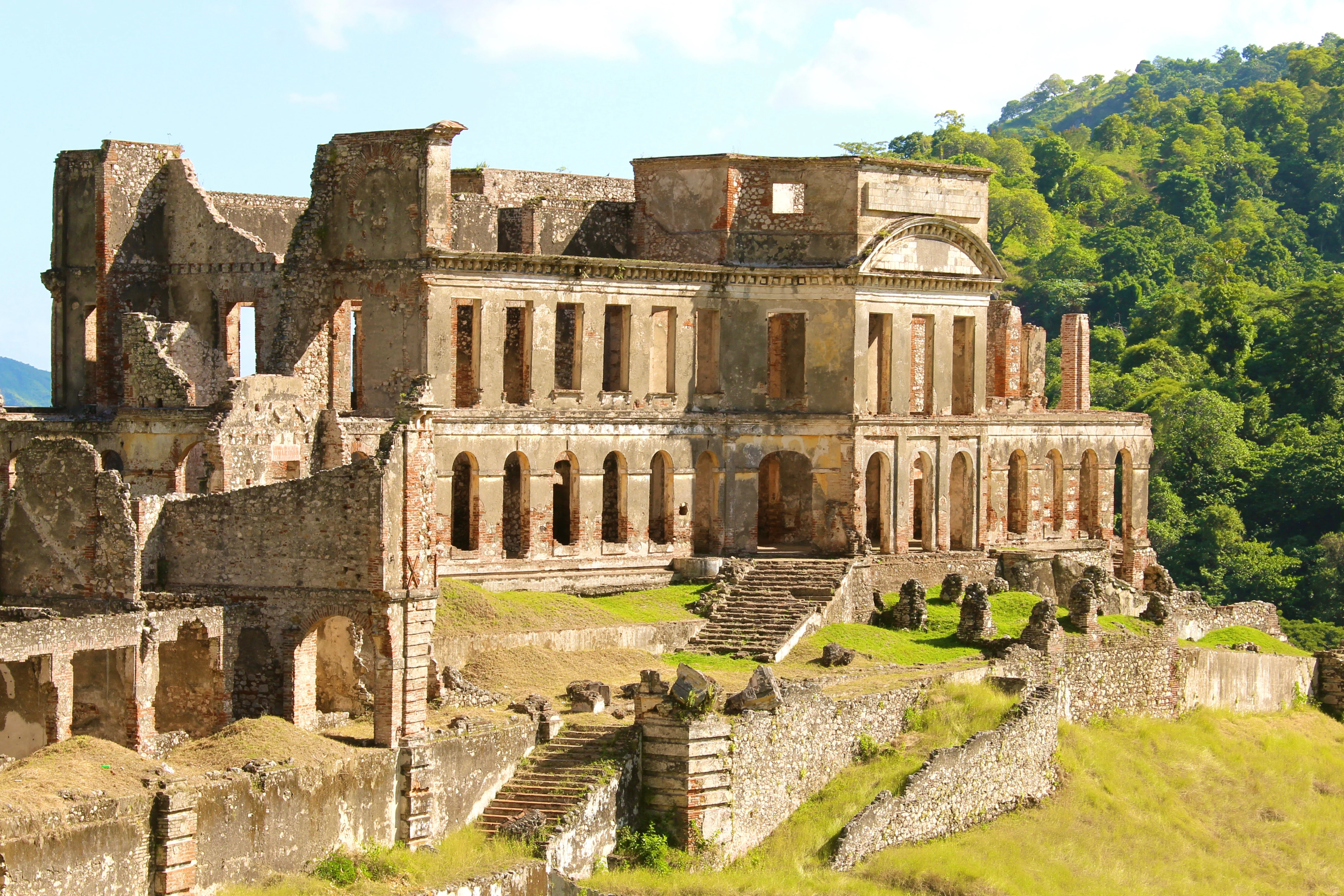
A wide angle view of the historic brick and stone ruins of Sans Souci Palace, showing multiple levels of arches and a grand central staircase, set against a backdrop of lush green forested hills.
The ruins of Sans Souci Palace, an 18th-century architectural landmark in northern Haiti.

Parc national historique - Citadelle, Sans Souci, Ramiers history and protected-area timeline

The park's cultural foundations are rooted in the decades immediately following Haiti's declaration of independence in 1804. The Citadelle La Ferrière was built to defend the northern part of the newly independent island against a possible French return and was constructed at roughly 900 meters elevation over an extended period of around fourteen years, drawing reportedly on approximately 20,000 workers. Lower in the foothills, the Sans-Souci Palace was created as a royal residence intended to rival European architectural models such as Versailles, supported by barracks, administrative buildings, and even an onsite hospital.

The ensemble functioned as a royal seat and the center of governance in northern Haiti under Henri Christophe, and the connected military sites formed a defensive system along the mountains. In 1842, a major earthquake severely damaged much of the complex, and the structures were never fully reconstructed after that event.

The historic structures were later brought under formal protection through the creation of a national historic park in 1968. The site was inscribed on the UNESCO World Heritage List in 1982 under cultural criteria (iv) and (vi). A 2010 decree confirmed the current boundaries of the park, around 25,286 hectares, and government plans envisaged the placement of 127 boundary markers beginning at the Milot bridge.

Parc national historique - Citadelle, Sans Souci, Ramiers landscape and geographic character

The park occupies a transition zone between Haiti's northern coastal plain and the steep forested massif of the interior. Near Milot, the terrain is relatively gentle, holding palace ruins, gardens, and the historical core of the royal ensemble. Rising above this plain, the land climbs sharply toward the Citadelle, whose massive stone walls sit at around 900 meters elevation, commanding long views over surrounding valleys and the coast.

Hydrological features shape much of the territory: named waterways such as the Rivière La Passe, Rivière Vaseux, Rivière Madan Elmon, and Ravine Saut d'Eau cross the park, and numerous springs (including Derrière La Source, Man Durand, Pierre, Bégot, and Source à Roi) have been recorded, reflecting both natural drainage and historical water management. The park also contains marked karst and cave features such as Voûte Adam (also known as Voûte Kadelia), Grand Gouffre, Ca Yenbe, and sites near Ramiers, indicating significant limestone geology below the surface.

These physical conditions produced, in part, why the Citadelle location was chosen in the first place: defensible heights, access to water, and visibility across routes approaching the north. The post-earthquake ruin topography of palace walls, arches, and staircases blends with this broader natural terrain, heightening the visual drama of the site.
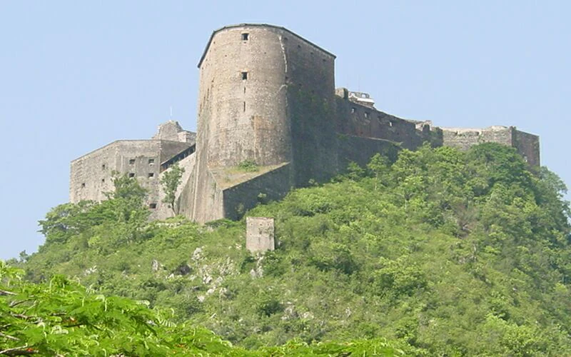
A large stone fortress with curved walls and ramparts, positioned on a steep, forested mountain peak under a clear sky.
The historic Citadelle Laferrière fortress set atop a lush mountain ridge in Haiti.

Parc national historique - Citadelle, Sans Souci, Ramiers ecosystems, habitats, and plant life

Although the park is officially classified as a cultural UNESCO site, it is also a Category V protected landscape under IUCN, recognizing its combination of natural, semi-natural, and built features. Its territory includes wooded slopes, river corridors, rocky ridges, and cave systems, supporting a mix of aquatic, forest, and karst habitat types.

The presence of multiple perennial rivers and recorded springs gives the park notable hydrological value, both for downstream communities and for the ecosystems that depend on these waters. The cave systems and limestone formations add a subterranean dimension to the park's ecology, while the forested foothills around Dondon contribute to watershed stability in northern Haiti.

The original French-language Wikipedia source notes that a dedicated biodiversity section for the park is currently empty or incomplete, suggesting that formal ecological inventories remain limited. With that gap in mind, the park should be understood principally as a historic landscape with significant but currently underdocumented natural values, especially around water resources, slopes, and karst systems.

Parc national historique - Citadelle, Sans Souci, Ramiers wildlife and species highlights

The source page does not provide a developed account of fauna or birdlife for the park, and a dedicated biodiversity section is flagged as empty on the French Wikipedia entry. There is therefore not enough directly supported material to build a substantive wildlife-specific narrative beyond noting that the park's mosaic of forested slopes, rivers, springs, and caves provides habitat conditions typical of northern Haitian uplands. Returning a detailed wildlife profile would risk invention, so this field is left empty based on the source.

Parc national historique - Citadelle, Sans Souci, Ramiers conservation status and protection priorities

Conservationally, the park is significant because it binds monumental cultural assets to a broader protected territory rather than treating them as isolated structures. Created nationally in 1968 and recognized internationally through UNESCO World Heritage inscription in 1982 under criteria (iv) and (vi), the park aims to preserve both the palace and fortress ensemble and the surrounding landscape that gave them strategic and economic meaning.

The IUCN Category V designation reflects an emphasis on landscape-scale protection, recognizing interactions between cultural features, forests, rivers, and karst terrain. A 2010 governmental decree formalized the present boundaries at roughly 25,286 hectares, and boundary-demarkation plans involving 127 markers underscore the intent to manage the park as a continuous, delimited territory rather than as scattered monuments.

The site also embodies an important conservation challenge: the ruins suffered major damage in the 1842 earthquake and have since been exposed to natural weathering, vegetation overgrowth, and deferred maintenance, making sustained protection, monitoring, and stabilization central to long-term preservation.

Parc national historique - Citadelle, Sans Souci, Ramiers cultural meaning and human context

Culturally, the park stands as the most prominent built legacy of Haiti's early independence era and the reign of Henri Christophe. The Sans-Souci Palace served not only as a royal residence but also as the administrative center of a kingdom, accompanied by royal chapels, barracks, arsenals, hospitals, and the Royal Chapel of Milot. The Citadelle, built in the years after independence in 1804, is emblematic of Haiti's determination to defend its freedom against a feared recolonialization attempt.

For Haitian national identity, this park represents an architectural and symbolic counterpoint to European colonial models: Sans-Souci was explicitly designed to rival palaces like Versailles, while the Citadelle projected military and political autonomy on a Caribbean scale. The 1842 earthquake and the abandonment of reconstruction gave the site its dramatic ruin character, a condition increasingly tied to its emotional and historical resonance in Haitian culture today.

Top sights and standout views in Parc national historique - Citadelle, Sans Souci, Ramiers

Among the standout features of the park is the 900-meter-high Citadelle La Ferrière, frequently described as the largest fortress in the Caribbean and a monumental expression of Haiti's post-1804 defensive strategy. Below it, the Sans-Souci Palace ruins form an enthralling royal residence ensemble, with associated structures such as the Royal Chapel of Milot, the Arsenal, the Briquis, lime kilns, and reservoirs completing a dense historic landscape rather than a single building.

Other notable points include the Ramiers signal and pyramid points, the watchpoint sites along the approaches to the Citadelle, and a network of secondary ruins at sites such as Dubreuil, Saut d'Eau, Presbytère, Ginette, Junca, and Hériveau. Natural assets such as Voûte Adam cave, Grand Gouffre, and the named river and spring network further enrich the park's profile, making it one of the rare places in the Caribbean where military, royal, religious, and natural heritage coexist within a single protected perimeter.

Best time to visit Parc national historique - Citadelle, Sans Souci, Ramiers

Like much of Haiti's north, the Milot and Dondon region experiences a tropical climate with a drier season and a wetter, hurricane-prone season. Visiting the park in the drier months tends to make traverses to the 900-meter Citadelle more comfortable and reduces the risk of trail disruptions from heavy rain.

Because the site combines lowland palace ruins with a high-elevation fortress climb, the cooler, drier season is generally better suited for experiencing both halves of the park in a single visit. Visitors considering the upper Citadelle should remain mindful that cloud cover and afternoon mists are common at higher elevations; clear-season mornings, when present, offer the strongest views.

Monthly climate preview

Long-term monthly temperature and precipitation rhythm recorded at representative coordinates

Parc national historique - Citadelle, Sans Souci, Ramiers Climate Normals and Temperature Patterns

Representative coordinates record measured annual temperature swings from cooler winter months to warmer midyear periods alongside varying monthly precipitation averages. Detailed monthly climate profiles provide deeper analytical context for long-term temperature and rainfall rhythms across the protected terrain.
Annual mean26 °C
23 °C28 °C
Jan23°
Feb24°
Mar24°
Apr25°
May26°
Jun27°
Jul28°
Aug28°
Sep27°
Oct26°
Nov25°
Dec24°
Warmest month
July

27.6 °C

Coolest month
January

23.1 °C

Wettest month
October

2.2 mm/day

Driest month
February

0.7 mm/day

Park location guide

Geography guide, regional context, and park location map for Parc national historique - Citadelle, Sans Souci, Ramiers

Parc national historique - Citadelle, Sans Souci, Ramiers park geography, regions, and map view in Haiti

Understand where Parc national historique - Citadelle, Sans Souci, Ramiers sits in Haiti through a broader geographic reading of the surrounding landscape, nearby location context, and its mapped position within the national park landscape.

How Parc national historique - Citadelle, Sans Souci, Ramiers fits into Haiti

Haiti is a Caribbean country occupying the western third of Hispaniola Island in the Caribbean Sea. It gained independence from France in 1804 following the Haitian Revolution, becoming the first sovereign state established by a slave revolt and the second independent nation in the Americas. The country is known for its complex political history, economic challenges, and cultural significance in the Caribbean.

Wider geography shaping Parc national historique - Citadelle, Sans Souci, Ramiers in Haiti

Haiti occupies the western third of Hispaniola Island in the Caribbean, sharing the island with the Dominican Republic. The country is positioned in the Caribbean Sea, east of Cuba and south of the Bahamas. Haiti's terrain is predominantly mountainous, with valleys and coastal plains. The country borders the Caribbean Sea on its western, southern, and southwestern coasts.

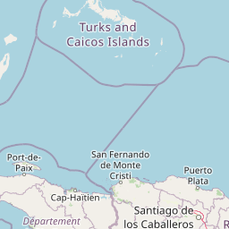
Map view of Parc national historique - Citadelle, Sans Souci, Ramiers

Use this park location map to pinpoint Parc national historique - Citadelle, Sans Souci, Ramiers in Haiti, understand its exact geographic position, and read its mapped placement within the surrounding landscape more clearly.

Pigeon | © OpenStreetMap contributors

Location context for Parc national historique - Citadelle, Sans Souci, Ramiers

Nord

Explore the mountain terrain, fortress ruins, and protected landscapes of northern Haiti

Visualizing Parc national historique - Citadelle, Sans Souci, Ramiers: Photos and Landscapes

Photographic collections reveal the steep mountain terrain, defensive walls, and forested valleys defining Parc national historique - Citadelle, Sans Souci, Ramiers. Visual records help researchers examine the unique protected landscape and architectural scale across the Haitian interior.

A wide angle view of the historic brick and stone ruins of Sans Souci Palace, showing multiple levels of arches and a grand central staircase, set against a backdrop of lush green forested hills.

Front view of the historic Sans Souci Palace ruins in Haiti, showing the main staircase and multi-level facade against a clear blue sky.

A large stone fortress with curved walls and ramparts, positioned on a steep, forested mountain peak under a clear sky.

Park atlas

Compare regional protected areas and connected historic landscapes

Other Parks Like Parc national historique - Citadelle, Sans Souci, Ramiers

Browsing other protected areas near Parc national historique - Citadelle, Sans Souci, Ramiers provides essential geographic context for regional terrain comparison. Extending the mapped exploration helps evaluate related conservation landscapes and surrounding mountain environments across the Caribbean.
National parkHaiti
About 0 km away#1 closest

West

National History Park National Park: Haiti's Protected Landscape and Geographic Atlas

Discover the park's mapped terrain and protected land geography.

The National History Park serves as a critical protected area within Haiti, offering detailed insights into its unique landscape and geographic setting. As a designated national park, it provides valuable data for atlas-based exploration of protected territories. Users can investigate the park's mapped boundaries, its regional context within Haiti, and the characteristics of its natural terrain, enriching their understanding of conservation landscapes.

Area
25.28 km²
Established
1968
IUCN
IV
Relief
Mountain
National parkHaiti
About 36 km away#2 closest

Northeast

Three Bays Protected Area National Park: Haiti's Extensive Marine and Coastal Protected Landscape

Mapped coral reefs, mangrove forests, and unique regional geography.

The Three Bays Protected Area in Haiti is a key national park established to conserve its vital marine and coastal environments. Covering over 75,000 hectares, it is the country's largest protected marine complex, encompassing extensive and healthy coral reefs, critical seagrass beds, and sprawling mangrove forests. This protected landscape provides essential ecosystem services and coastal protection, showcasing a significant portion of Haiti's natural heritage and regional geographic context along its northeastern shoreline.

Area
754.06 km²
Established
2014
IUCN
IV
Relief
Lowland
National parkMonte Cristi Province
About 68 km away#3 closest

East

Monte Cristi National Park: Dominican Republic National Park Geography and Atlas

Explore mapped boundaries and regional landscape context.

Monte Cristi National Park serves as a vital component of the Dominican Republic's protected lands, located within the Monte Cristi Province. This entry provides essential geographic context and visualizes the park's mapped boundaries, contributing to a comprehensive understanding of its landscape. Delve into the atlas perspective of this national park, examining its terrain and regional significance for structured geographic exploration.

Area
550 km²
Established
1983
IUCN
II
Relief
Upland
National parkDominican Republic
About 91 km away#4 closest

East

José Armando Bermúdez National Park: Dominican Republic National Park Atlas and Landscape Context

Discover the mapped protected area and geographic setting of this Dominican Republic national park.

Gain an understanding of José Armando Bermúdez National Park as a distinct protected landscape within the Dominican Republic. This entry focuses on its role as a national park, providing geographic context and highlighting its mapped boundaries for atlas exploration. Explore the park's specific terrain and its place within the nation's conservation network.

Area
766 km²
Established
1956
IUCN
II
Relief
Mountain
Watercolor painting of hilly, terraced green mountains and ridges in soft pastel tones.
National parkHaiti
About 136 km away#5 closest

South

Parc national La Visite: Atlas and Geographic Overview of Haiti Protected Highlands

Highland pine forest refuges and karst limestone landscapes.

Located in the Chaîne de la Selle, Parc national La Visite serves as a key conservation anchor for the unique upland ecosystems of Haiti. This detailed atlas entry maps the park's steep limestone plateaus, deep gorges, and expansive pine forests, providing essential context on one of the Caribbean's most significant transboundary protected mountain landscapes.

Established
1983
National parkHaiti
About 138 km away#6 closest

South

La Visite National Park: Protected Highland Terrain and Endemic Pine Forest Landscape

Explore the geography and mapped park boundaries of Haiti's significant national park.

La Visite National Park is a vital protected area located in Haiti's mountainous Massif de la Selle region. It is distinguished by its rare montane ecosystems, including extensive Hispaniolan pine forests and high-altitude grasslands, creating a unique landscape within the Caribbean. This atlas entry focuses on the park's geographic setting, its mapped protected boundaries, and its ecological significance as a key component of Haiti's natural heritage, offering a detailed look at its distinctive terrain.

Area
30 km²
Established
1983
IUCN
II
Relief
Mountain
A soft watercolor painting depicting a panoramic view of rolling green hills, a forest canopy, and distant mountains under a pale, warm-toned sky.
National parkHaiti
About 138 km away#7 closest

South

Parc national La Visite: Protected Highland Plateau and Pine Forest Geography in Haiti

Mapping the Massif de la Selle mountain ecosystems.

Parc national La Visite occupies a critical position in southeastern Haiti, protecting a rugged highland plateau defined by dense ravines and Haiti's largest surviving pine forest. This protected area offers a distinct geographic window into the cool, montane terrain of the Massif de la Selle, serving as an essential core zone for regional conservation and mountain landscape study.

Area
30 km²
Established
1983
IUCN
II
National parkSud Department
About 140 km away#8 closest

South

Forêt des Pins National Park: Geographic Overview of Haiti's Highland Protected Landscapes

Mapping the pine-forested terrain and high-altitude mountain ecosystems of the southern massif.

Explore the expansive geography of Forêt des Pins National Park, which protects the remnants of Haiti's highland Caribbean pine forests. This protected area spans critical high-elevation slopes and mountain watersheds, offering a detailed look at the rugged natural terrain of the southern massif surrounding Pic la Selle.

Area
187.8 km²
Established
1937

Common questions about visiting, size, designation, and location context for Parc national historique - Citadelle, Sans Souci, Ramiers

Parc national historique - Citadelle, Sans Souci, Ramiers FAQs for park facts, access, geography, and protected area context

Find quick answers about Parc national historique - Citadelle, Sans Souci, Ramiers, including protected-area facts, park geography, trail and visitor context, and how the park fits into its surrounding country and regional landscape.
MoriAtlas Explorer

Continue Your Protected Areas Search Across the Global Atlas

Deepen your exploration by continuing the structured search for national parks and protected areas worldwide. Utilize the comprehensive filtering capabilities to compare different conservation landscapes and refine your understanding of global park geography. Discover more about the distribution and characteristics of protected natural areas.

Global natural geography