
Mori Atlas logo
National parkDe Maasduinen National Park

Discover the Protected Areas and Unique Terrain of Limburg's Iconic Dune System

De Maasduinen National Park: Mapping the Longest River Dune Landscape in the Netherlands

(Nationaal Park De Maasduinen)

De Maasduinen National Park in the province of Limburg presents an exceptional protected landscape, characterized by the longest river dune chain in the Netherlands. This national park showcases a unique geography shaped by wind and water over millennia, offering a rich tapestry of heathlands, forests, and wetlands. Explore its mapped boundaries and distinct terrain, understanding its role as a significant natural corridor within regional Dutch and German conservation efforts.

National ParkHeathlandRiver DunesWetlandsPine ForestLimburg
Stylized illustration of a lake with reflective water, grassy shoreline, sandy path, and colorful cliffs under a clear sky

De Maasduinen National Park

National park

Park overview

Structured park overview, official facts, and landscape profile for De Maasduinen National Park

De Maasduinen National Park park facts, protected area profile, and essential visitor context

Review the core facts for De Maasduinen National Park, including designation, size, terrain, visitor scale, habitats, and operating context in one park-focused overview.

About De Maasduinen National Park

De Maasduinen National Park occupies a distinctive position in the Dutch protected area network as the longest linear nature reserve in the Netherlands. The park stretches over twenty kilometers along a sandy ridge between the Meuse River and the German border, with an average width of just two to three kilometers. This elongated form reflects the geological origins of the landscape, which was shaped by the ancient course of the Rhine and subsequent wind erosion during the late glacial period. The parabolic dunes, some of the most distinctive in northwestern Europe, give the park its name and define its visual character. The interior contains a mosaic of dry heathlands on the dune crests, damp fens in the interdunal valleys, and mature pine and deciduous forests that have developed since extensive planting in the nineteenth century. The estate known as De Hamert forms the historical and geographic core of the park, and until 1998 the protected area carried this name before being renamed to emphasize the broader dune landscape. Several former sand and gravel extraction sites within the park have been restored and now contribute to the habitat diversity.

Quick facts and research context for De Maasduinen National Park

De Maasduinen National Park is located in North Limburg, Netherlands, straddling the municipalities of Bergen and Gennep. The park covers roughly 45 square kilometers along a sandy plateau adjacent to the Meuse River, within sight of the German border. It was established in 1996 under IUCN category II and is managed collaboratively by Staatsbosbeheer, Stichting het Limburgs Landschap, the municipality of Bergen, and private landowners. The park contains the longest river dune chain in the Netherlands, with parabolic dunes dating back to the last ice age. Prior to the 20th century, active drifting sand was common across the area, but forestry programs largely stabilized these formations.

Protection and recognition

Documenting the official terrestrial boundaries and conservation framework of the Dutch landscape

De Maasduinen National Park Protection Status and Official Terrestrial Designation

De Maasduinen National Park is categorized under a terrestrial protection scope to preserve its unique inland dune systems and regional geography. Verifying the documented designation history and management status provides clear context regarding the official international standing of the protected lands.

Protection details

Protection scope
Terrestrial
Transboundary protection
No
Park context

Deeper park guide and search-rich context for De Maasduinen National Park

De Maasduinen National Park history, landscape, wildlife, and travel context

Explore De Maasduinen National Park through its history, landscape character, ecosystems, wildlife, conservation priorities, cultural context, and seasonal travel timing in a structured park guide built for atlas discovery and search intent.

Why De Maasduinen National Park stands out

De Maasduinen is best known for its exceptional parabolic dune landscape, the longest river dune system in the Netherlands, which was formed by wind action during the last glaciation. The park is also recognized for its extensive heathlands and the presence of large grazing animals including Galloway cattle and Kempische heideschapen that help maintain the open character of the heath. The area serves as an important corridor for migrating cranes, which stop in the park's wetland complexes during spring and autumn migrations. The rare European nightjar nests in the Bergerbos section, and the park supports populations of smooth snakes, sand lizards, and several bat species.
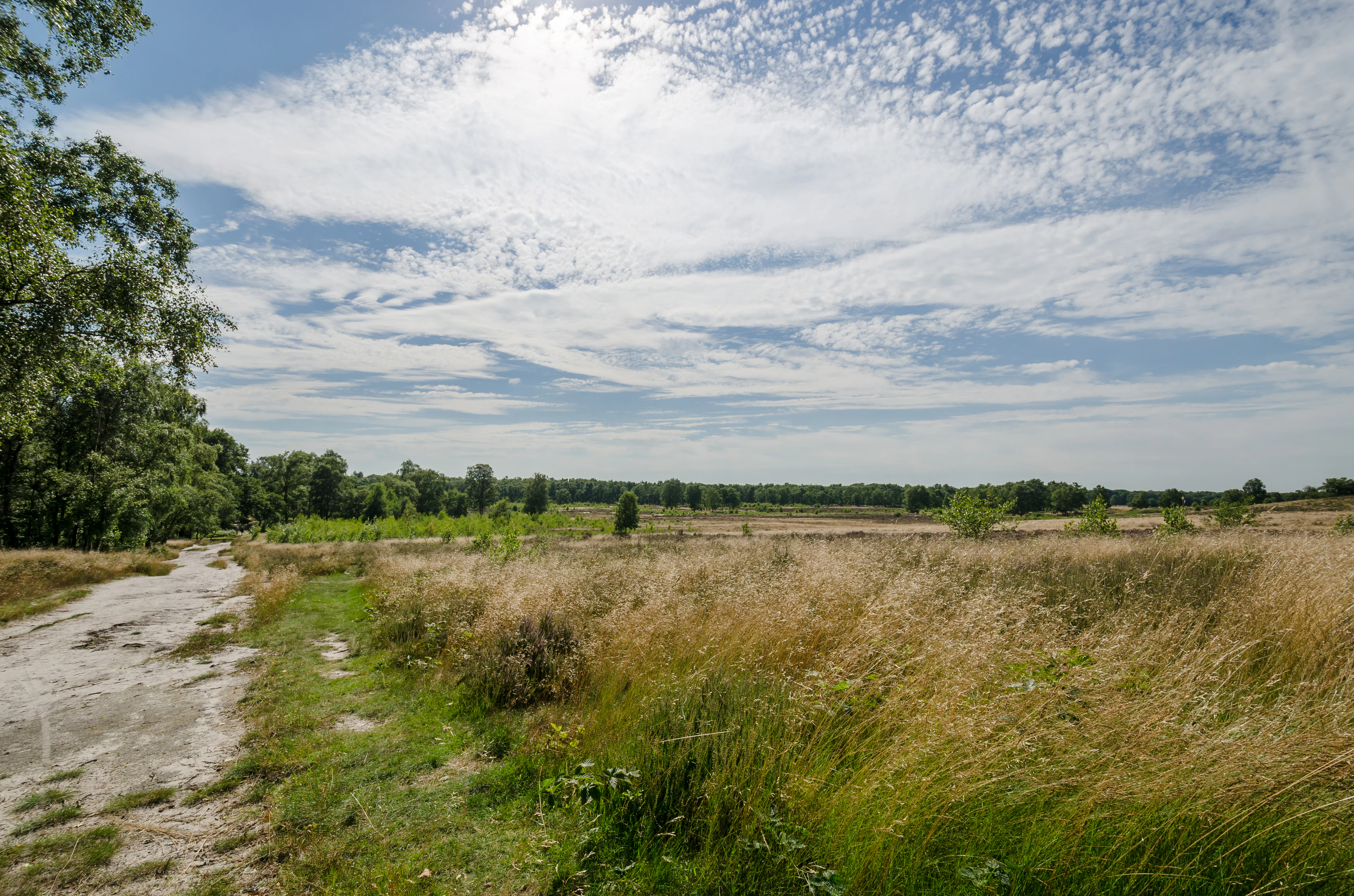
Sandy path with grassy field, trees in background, and blue sky with scattered clouds
Grassy field and sandy path in De Maasduinen National Park, Netherlands

De Maasduinen National Park history and protected-area timeline

The geological history of De Maasduinen spans roughly 21,000 years to the last ice age, when the landscape was exposed to extreme cold and dryness. During this period, powerful westerly winds lifted sand from the broad, unvegetated plain and deposited it on the eastern banks of the Meuse, creating the characteristic parabolic dune forms. The park contains the longest river dune belt in the Netherlands, a geological feature of considerable scientific and landscape value. Human activity has shaped the area since prehistoric times, with deforestation during the Roman period and intensified agriculture from the sixth century onward progressively altering the natural vegetation. The establishment of the potstal system for sheep farming led to overgrazing and the formation of active drifting sands across large areas. In the nineteenth century, extensive pine plantations were established to stabilize these shifting sands. The modern protected area emerged from a series of nature reserves established through the twentieth century, which were consolidated into De Maasduinen National Park in 1996. The park was originally named De Hamert after the principal estate at its center, but was renamed in 1998 to reflect the broader geographic and geological identity of the area.

De Maasduinen National Park landscape and geographic character

The physical landscape of De Maasduinen is defined by a sequence of parabolic dunes oriented roughly parallel to the Meuse River, forming a distinctive undulating terrain across the sandy plateau. These dunes, which date from the final phase of the last glaciation, represent the most extensive river dune system in the Netherlands. The dune crests are typically stabilized by heath vegetation and pine forest, while the interdunal depressions contain fens and wet heath communities. The area lies on a long, narrow sand ridge that rises slightly above the surrounding agricultural landscape, creating a natural corridor running from north to south along the Dutch-German border. Former sand and gravel extraction in the 1980s created additional water bodies within the park, adding to the diversity of wetland habitats. The forest cover is a combination of planted coniferous stands and more natural deciduous woodlands of oak, birch, and beech.

De Maasduinen National Park ecosystems, habitats, and plant life

The ecological character of De Maasduinen reflects the combination of dry heathland, damp fen, and woodland habitats that occur across the dune landscape. The heathlands, maintained by grazing and historical land use, support specialized plant communities adapted to acidic, nutrient-poor soils. The fens in the dune valleys provide contrasting wetland conditions with distinctive flora including the rare marsh gentian and bog myrtle. The forest habitats range from coniferous plantations to more mature deciduous woodlands, with oak, birch, pine, alder, and beech as the principal tree species. The mosaic of open heath, woodland, and wetland creates a diversity of ecological niches that supports the notable biodiversity recorded in the park, including at least 26 dragonfly species and 33 butterfly species.

De Maasduinen National Park wildlife and species highlights

De Maasduinen supports a noteworthy assemblage of reptile and amphibian species, including the smooth snake, natterjack toad, sand lizard, slow worm, and viviparous lizard. The wetland areas and heathlands provide habitat for a range of bird species characteristic of open and marshy terrain, with the common crane being particularly notable as a migrating species that stops to rest in the park's fen complexes during spring and autumn. Other characteristic birds include the European nightjar, Eurasian hobby, western marsh harrier, black woodpecker, and common kingfisher. Several marten species occur in the park, along with Eurasian beavers that have expanded into the wetter areas from reintroduction programs elsewhere in Limburg. Bat species present include the common pipistrelle and brown long-eared bat, utilizing the woodland and built structures for roosting.

De Maasduinen National Park conservation status and protection priorities

The park is designated under IUCN category II as a national park and is part of the broader Natura 2000 network of European protected areas. The management strategy focuses on maintaining the open heathland character through controlled grazing by sheep and large herbivores including Galloway cattle and land goats, which prevent the natural succession of woodland onto former heath areas. A key objective is the ecological connection of De Maasduinen with adjacent nature reserves, creating a larger functional landscape that facilitates species movement between the Netherlands and Germany. The park forms part of a chain of protected areas along the eastern bank of the Meuse, connecting through National Park De Meinweg toward the German border. The maintenance of the parabolic dune system and the associated heath and fen habitats represents a conservation priority, as these are declining habitat types in the Dutch context.

De Maasduinen National Park cultural meaning and human context

The De Maasduinen area has been inhabited and used by humans since prehistoric times, with archaeological evidence of continuous occupation from the Roman period onward. The traditional agricultural practice of keeping sheep on the heathlands using the potstal system contributed both to the historical economy of the region and to the formation of the characteristic open landscape. The name De Maasduinen, which translates to The Dunes of the Meuse, reflects both the geographical position along the river and the dominant landform. The region encompasses the municipalities of Bergen and Gennep and is sometimes used as a broader regional name for this part of North Limburg, distinguishing it from the adjacent Land of Cuijk on the Brabant side of the river and the German Kleve district across the border.

Top sights and standout views in De Maasduinen National Park

The longest river dune chain in the Netherlands, with well-preserved parabolic dunes from the last glaciation, forms the park's most distinctive feature. The heathlands, maintained by traditional grazing, provide one of the most extensive semi-natural landscapes in the Dutch lowlands. The crane migration corridor passes through the park, with these impressive birds stopping to rest in the wetland complexes during seasonal movements. The Bergerbos section holds the rare European nightjar, a species of conservation concern in northwestern Europe. The combination of dry heath, damp fen, and woodland creates a habitat mosaic that supports exceptional invertebrate diversity, with more than 30 butterfly species and 26 dragonfly species recorded.

Best time to visit De Maasduinen National Park

The park can be visited throughout the year, with each season offering a different character. Spring and early summer bring the heathland into flower and are optimal for observing heathland-specialist butterflies and breeding birds. Autumn is particularly notable for the crane migration, when groups of these large birds can be observed resting in the park's wetland areas. The deciduous forests display strong seasonal color in autumn. Winter, while quieter, offers the opportunity to observe the park's structure and geology without foliage cover and to see the large grazing animals moving through the open heathland.


Monthly climate preview

Long term representative averages tracking temperature cycles and daily precipitation

De Maasduinen National Park Climate Normals and Monthly Weather Patterns

Representative measurements from Limburg show average temperatures peaking near 18.6 degrees Celsius in July and dropping to around 1.8 degrees Celsius in January, with relatively steady precipitation throughout the year. Exploring the complete monthly climate profile reveals deeper historical normals for average minimums and maximums across thirty years of climatology data.
Annual mean10 °C
2 °C19 °C
Jan
Feb
Mar
Apr10°
May14°
Jun17°
Jul19°
Aug18°
Sep15°
Oct10°
Nov
Dec
Warmest month
July

18.7 °C

Coolest month
January

1.9 °C

Wettest month
December

2.6 mm/day

Driest month
April

1.5 mm/day

Park location guide

Geography guide, regional context, and park location map for De Maasduinen National Park

De Maasduinen National Park park geography, regions, and map view in Netherlands

Understand where De Maasduinen National Park sits in Netherlands through a broader geographic reading of the surrounding landscape, nearby location context, and its mapped position within the national park landscape.

How De Maasduinen National Park fits into Netherlands

The Netherlands is a low-lying coastal country in Northwestern Europe, famous for its extensive dike and canal systems that reclaim land from the sea. It consists of twelve provinces and is known for tulips, windmills, and cycling culture. The country is a founding member of the European Union with Amsterdam as its capital and The Hague as the seat of government.

Wider geography shaping De Maasduinen National Park in Netherlands

The Netherlands is located in Northwestern Europe along the North Sea coastline to the north and west. It borders Germany to the east and Belgium to the south. The country is notably flat, with a significant portion of its territory lying below sea level, protected by dikes and dune systems. It consists of twelve provinces and also includes overseas municipalities in the Caribbean.

Map view of De Maasduinen National Park

Use this park location map to pinpoint De Maasduinen National Park in Netherlands, understand its exact geographic position, and read its mapped placement within the surrounding landscape more clearly.

Pigeon | © OpenStreetMap contributors

Location context for De Maasduinen National Park

Limburg
Recorded earthquake history

Explore the Seismic History and Recorded Earthquake Catalogue for De Maasduinen National Park

Review historical earthquake data associated by proximity with De Maasduinen National Park. MoriAtlas provides a clear, searchable catalogue of recorded seismic events, allowing users to analyze ground movement history across the park and its surrounding landscapes in Limburg.

De Maasduinen National Park Earthquake History

Catalogued events

79 events

Strongest magnitude

Magnitude 5.4

Most recent event

Sep 8, 2011

This history includes earthquakes recorded inside the park or within 50 km of its borders

Explore the defining river dune formations, expansive heathlands, and diverse wetland habitats of this protected area.

De Maasduinen National Park Photos: Visual Guide to Its Unique Dutch Landscapes

Browse an extensive collection of images showcasing De Maasduinen National Park, the Netherlands' longest river dune system and a unique protected landscape. These photographs provide essential visual context for understanding the park's distinctive parabolic dune terrain, varied heathlands, and vital wetland environments, revealing the interplay of ancient glacial formations and ecological corridors.

Sandy path with grassy field, trees in background, and blue sky with scattered clouds

Calm lake with a single tree on the shore, forested background, and clear blue sky

Park atlas

Compare other national parks, nature reserves, and protected landscapes across the Dutch province of Limburg and its cross-border regions.

Explore More National Parks and Protected Areas Near De Maasduinen in Limburg

Explore national parks and protected areas near De Maasduinen National Park, mapping similar conservation landscapes and regional park geography within Dutch Limburg. Continue your park discovery by comparing their distinct geographic characteristics and conservation efforts, gaining valuable context within the broader protected-area network of this border region.
Nature reserveNorth Rhine-Westphalia
12 km away#1 closest

Northeast

Unterer Niederrhein Nature Reserve: Geographic Atlas and Floodplain Landscape Mapping

Riverine wetland ecosystems in North Rhine-Westphalia

Uncover the protected landscape of Unterer Niederrhein, an expansive bird protection area along the German Lower Rhine. The region features a mosaic of sand banks, oxbow lakes, and seasonally flooded grasslands, creating a highly interconnected riverine ecosystem that spans across the districts of Kleve and Wesel.

Area
258.094 km²
Established
1983
Relief
Lowland
Climate
Temperate
A soft, light-toned watercolor painting depicting a marshy wetland with patches of grass and distant low trees against a pale, washed-out sky.
Nature reserveNorth Rhine-Westphalia
About 13 km away#2 closest

North

Kranenburger Bruch Nature Reserve: Geography and Protected Wetland Landscapes in North Rhine-Westphalia

A preserved Niedermoor relic in the Düffel floodplain

Kranenburger Bruch stands as a prominent nature reserve in North Rhine-Westphalia, protecting a distinct lowland peat bog and alder carr forest. The area is defined by a low-lying basin topography, seasonal shallow pools, and hedgerow-lined pastures that characterize the traditional Düffel region. This reserve is recognized for its ecological density, hosting diverse birdlife and rare wetland flora across a network of brooks and open water bodies.

Area
1.18 km²
Established
1981
Relief
Lowland
Climate
Temperate
A soft watercolor painting of a winding river surrounded by grassy plains and distant hills, rendered in pale greens and neutral tones.
Protected areaNorth Rhine-Westphalia
About 17 km away#3 closest

South

Schwalm-Nette-Platte mit Grenzwald und Meinweg Protected Area Map and Landscape Analysis

Regional bird sanctuary and habitat mosaic in North Rhine-Westphalia

Schwalm-Nette-Platte mit Grenzwald und Meinweg encompasses roughly 77 square kilometers of varied lowland terrain, featuring pine and oak forests, dry heaths, and wetlands. This geographic overview highlights the unique arrangement of habitats that sustain significant migratory and breeding bird species across the Lower Rhine plain, providing a clear perspective on its role as a cross-border ecological site.

Area
77.22 km²
Established
1983
Watercolor illustration of a peaceful lakeside landscape with soft green trees, rolling hills, and a calm body of water.
Protected landscapeGermany
About 21 km away#4 closest

South

Naturpark Maas-Schwalm-Nette: Geography, Protected Landscapes, and Regional Map Context

A cross-border protected area spanning Germany and the Netherlands

Naturpark Maas-Schwalm-Nette encompasses a wide cross-border expanse defined by the interaction of three distinct river systems. This protected landscape contains notable natural formations including the Krickenbecker Seen peat lakes and the juniper heath of the Lower Rhine. With terrain ranging from quiet border forests to extensive wetlands, the park serves as a primary geographic link between regional conservation zones in Germany and the Netherlands.

Area
870 km²
Established
2002
Relief
Lowland
Climate
Temperate
Watercolor painting of a soft, hazy forest landscape with a pond in the foreground.
Nature reserveNorth Rhine-Westphalia
About 22 km away#5 closest

South

Kaldenkirchener Grenzwald Nature Reserve in North Rhine-Westphalia

Regional border forest with heath moors and rare arboretum stands

Explore the geographic character of the Kaldenkirchener Grenzwald, a significant nature reserve located in the Nettetal region. This area showcases the interplay between native sandy pine forests and protected heath moor remnants, while incorporating the unique Sequoiafarm arboretum. Gain insights into the border landscape of the Lower Rhine and the historical ecological restoration that defines this protected area within Germany.

Established
1949
Relief
Lowland
Climate
Temperate
Access
Easy access
Watercolor painting of a peat bog ecosystem featuring green trees, pink and yellow vegetation, a body of water, and distant mountains
National parkNetherlands
27 km away#6 closest

Southwest

De Groote Peel National Park: Mapped Boundaries of a Unique Raised Bog & Wetland

Protected area with exceptional birdlife and peat landscape.

De Groote Peel National Park represents a crucial protected landscape in the Netherlands, renowned as one of the last substantial raised bogs in Western Europe. Its terrain is characterized by a distinct blend of open lakes formed by historical peat extraction, heathland expanses, and sensitive peat swamps. This Ramsar-designated wetland is a vital habitat for numerous bird species, offering unique opportunities for landscape context and atlas exploration of its ecological significance and mapped geographic features.

Area
13.4 km²
Established
1993
IUCN
II
Relief
Lowland
Nature reserveKrefeld
27 km away#7 closest

Southeast

Hülser Bruch Nature Reserve: Geographic Atlas and Protected Landscape Mapping for Krefeld

A historic glacial plain and protected wetland habitat in the Lower Rhine region.

Hülser Bruch represents a vital protected area in Krefeld, characterized by clay rich soils, high groundwater levels, and ancient brook channels. The reserve preserves a distinct mosaic of coppice woodland and earthen embankments that reveal the geomorphological influence of Pleistocene ice sheets on this lowland territory.

Area
4.3 km²
Established
2002
Relief
Lowland
Climate
Temperate
A watercolor painting showing soft, light green and pink rolling hills with stylized trees against a white background.
Nature reserveNorth Rhine-Westphalia
27 km away#8 closest

Northeast

Hetter-Millinger Bruch Nature Reserve: An Atlas of North Rhine-Westphalia Floodplain Landscapes

Protected wet grasslands and drainage networks near the Rhine

Hetter-Millinger Bruch constitutes an expansive nature reserve in the Lower Rhine region, noted for its four-part structural design and commitment to habitat management. Spanning a landscape of open meadows, grazing pastures, and antique land drainage systems, the reserve acts as a vital ecological corridor along the border of Germany and the Netherlands. Its flat, low-lying terrain provides a classic representation of regional riverine geography.

Area
6.6 km²
Established
1989
IUCN
IV

Common questions about visiting, size, designation, and location context for De Maasduinen National Park

De Maasduinen National Park FAQs for park facts, access, geography, and protected area context

Find quick answers about De Maasduinen National Park, including protected-area facts, park geography, trail and visitor context, and how the park fits into its surrounding country and regional landscape.
MoriAtlas Explorer

Continue Your Protected Areas Search Across the Global Atlas

Deepen your exploration by continuing the structured search for national parks and protected areas worldwide. Utilize the comprehensive filtering capabilities to compare different conservation landscapes and refine your understanding of global park geography. Discover more about the distribution and characteristics of protected natural areas.

Global natural geography