
Mori Atlas logo
Nature reserveKranenburger Bruch

A rare lowland peat bog and alder carr relic within the Düffel floodplain region

Kranenburger Bruch Nature Reserve: Mapping the Protected Wetland Landscapes of North Rhine-Westphalia

(Naturschutzgebiet Kranenburger Bruch)

Kranenburger Bruch serves as a critical protected lowland peat bog, or Niedermoor, situated in the low-lying basin of the North Rhine-Westphalia region. This nature reserve provides essential wetland habitat, featuring a complex of reedbeds, wet meadows, and spring-fed streams that originate from the adjacent Klever Reichswald heights. The mapped terrain reflects a historically significant Düffel floodplain landscape, preserved through ongoing conservation efforts and traditional land management techniques.

wetlandNiedermoorlowland peat bogalder carr forestreedbedswet meadows
A digital illustration of a scenic valley featuring a winding river, a central waterfall flowing from steep mountains, and dark green pine trees in the foreground, all rendered in a flat, pastel-toned graphic art style.

Kranenburger Bruch

Nature reserve

Park overview

Structured park overview, official facts, and landscape profile for Kranenburger Bruch

Kranenburger Bruch park facts, protected area profile, and essential visitor context

Review the core facts for Kranenburger Bruch, including designation, size, terrain, visitor scale, habitats, and operating context in one park-focused overview.

About Kranenburger Bruch

Kranenburger Bruch is a compact but ecologically distinctive nature reserve set in the lowest part of North Rhine-Westphalia, within the Düffel floodplain of the Lower Rhine. Sit nature just east of the historic town of Kranenburg, near the Dutch border, it occupies a shallow basin at the foot of the Niederrheinischer Höhenzug, where push moraine ridges accumulated at the edge of the former ice sheets. This setting gives the reserve its defining hydrology: rainwater and abundant springs discharge from the wooded heights of the Reichswald down into the basin, maintaining the high water table on which the wetland depends.

The reserve is not a single uniform habitat. Instead it combines relict lowland peat bog (Niedermoor), fragments of original alder carr forest (Erlenbruchwald), wet meadows, reedbeds, hedges, shallow open-water pools, and a sizeable gravel extraction lake. These different elements sit close together, which is a key reason for the area's biodiversity. The hedges in particular are noted as a defining feature of the Düffel and help to slow wind erosion while providing nesting and feeding habitat for many species.

Standing at the meeting point of the former Roman road from Xanten to Nijmegen and an old route into the Düffel, the broader landscape around Kranenburger Bruch has a long history of human use. Drainage and colonisation began in the Middle Ages, with significant agricultural transformation in the 19th and 20th centuries, but a partial reversal has occurred since the 1950s through land abandonment, rewetting of ditches, and the adoption of extensive grazing and mowing practices. Today the protected area is valued both as a surviving peat relic and as a working example of low-intensity wetland management in an intensively used agricultural region.

Quick facts and research context for Kranenburger Bruch

Kranenburger Bruch is located east of the town of Kranenburg in the district of Kleve, North Rhine-Westphalia, and is part of the Düffel floodplain of the Lower Rhine near the Dutch border. It covers roughly 115 to 118 hectares and reaches the lowest point in North Rhine-Westphalia at about 10.7 metres above sea level. The area has been protected since 1985 and is embedded within the larger Unterer Niederrhein wetland system, recognised as a Ramsar site since 1983 and as an EU FFH site since 2004. Management combines extensive grazing with hardy cattle breeds, seasonal reed cutting, and the maintenance of shallow open water features for wetland species.

Protection and recognition

Terrestrial protected area records established in 1985

Kranenburger Bruch Protection Status and Designation History

Kranenburger Bruch holds documented terrestrial protection status established in 1985 across official database records. Review the registered designation history, management scope, and international recognition details compiled for this protected area.

Protection details

Protection scope
Terrestrial
Designated year
1985
Transboundary protection
No
WDPA ID
164232
Park context

Deeper park guide and search-rich context for Kranenburger Bruch

Kranenburger Bruch history, landscape, wildlife, and travel context

Explore Kranenburger Bruch through its history, landscape character, ecosystems, wildlife, conservation priorities, cultural context, and seasonal travel timing in a structured park guide built for atlas discovery and search intent.

Why Kranenburger Bruch stands out

Kranenburger Bruch is best known as one of the last intact Niedermoor, or lowland peat bog, relics along the lower German Rhine, a wetland type that has largely disappeared elsewhere in the region under centuries of drainage. The reserve is also strongly associated with the transition from lowland peat to alder carr forest, with tall hedges characteristic of the Düffel, with shallow seasonal pools (Blänken) that support rare aquatic plants, and with a network of spring-fed brooks descending from the Reichswald above. It is equally recognised as a regionally important bird area, hosting breeding populations of reed bunting, marsh and pond warblers, whinchat, bluethroat, kingfisher, lapwing, snipe, and water rail, alongside grazing geese in winter. The combination of bog relic, wet meadows, reedbeds, hedgerows, and the Abgrabungssee gravel lake gives the reserve a remarkable ecological density within a relatively compact area.
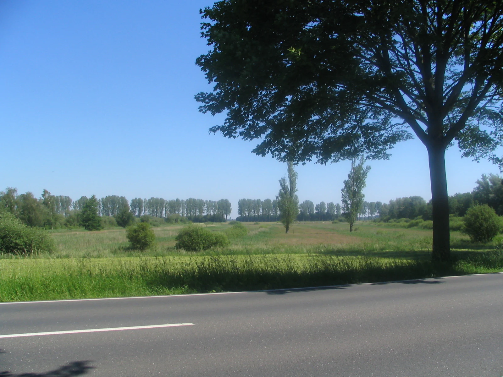
A paved road with a white line in the foreground, leading past a large tree on the right towards a green wetland field with scattered trees and a distant tree line under a clear blue sky.
View of the wetland landscape near Nütterden as seen from the B9 federal road

Kranenburger Bruch history and protected-area timeline

Kranenburger Bruch took shape at the end of the last ice age, when regular flooding of the Rhine eroded and redeposited sediments across the lower terrace landscape, gradually transforming it into a floodplain of gravel banks, levees, and runoff channels. Where the push moraine wall of the Niederrheinischer Höhenzug created a shallow depression, permanently high groundwater encouraged the development of a lowland peat bog (Niedermoor), which in turn supported alder carr forest, with alternating layers of clay and peat accumulating over time.

Human intervention began in the medieval period. In the 13th century, the Counts of Cleves brought in Dutch drainage specialists known as Broekers to drain the marsh and reclaim land for settlement. They cleared the alder forest and laid out a network of ditches (Weteringen), creating the strip-field pattern of the Lange Hufen and Kurze Hufen named in old Frankish Hufe units. A motte-and-bailey fortress was also established by the Groesbeek inflow, recorded as a Festes Haus in 1270 and giving the town of Kranenburg its name. In 1343, Dietrich von Horn issued a Deichordnung, or dike statute, for Kranenburger Bruch that is considered among the oldest dike ordinances on German territory.

Intensified drainage in the early 20th century converted much of the remaining wetland into arable land, but from the 1950s onward agricultural use in the southern part declined, allowing reedbeds and species-rich wet meadows to develop once more. In 1983 the area became part of the Ramsar-recognised Unterer Niederrhein wetland, and in 1985 it was formally designated as the Naturschutzgebiet Kranenburger Bruch, followed by designation as an EU FFH site in 2004. Conservation efforts have since focused on rewetting, extensive grazing, reed cutting, and the maintenance of shallow pools for rare wetland species.

Kranenburger Bruch landscape and geographic character

The landscape of Kranenburger Bruch is defined by its position at the lowest elevation in North Rhine-Westphalia, around 10.7 metres above sea level, set within a shallow depression at the foot of the Klever Reichswald and the Niederrheinischer Höhenzug. The basin floor consists of layered deposits of clay and peat, shaped historically by Rhine flooding and by sediment trapped between ice-pushed ridges. The terrain is therefore extremely flat, dotted with shallow pools, drainage ditches, and the larger Abgrabungssee gravel lake.

The surrounding Düffel landscape is characterised by long, low-lying meadows and pastures crossed by a network of spring-fed brooks descending from the wooded heights. Old course names such as Rodebeeke, Klarebeeke, Schwarte Water, and Groesbeek reflect the colour and chemistry of the spring water, related to bog iron, acidity, and humic content. A striking visual signature of the Düffel, including Kranenburger Bruch, is its dense pattern of hedges and tree lines, including avenues of hybrid poplars whose origins reach back to the Napoleonic period. Together these features produce a quiet, low-key wetland scenery that contrasts sharply with the bordering hill forests.

Kranenburger Bruch ecosystems, habitats, and plant life

The vegetation of Kranenburger Bruch is built around the surviving Niedermoor and its derivatives: fragments of alder carr forest, tall sedge and reed communities, wet meadows, and seasonally flooded grasslands. Layers of clay and peat in the subsoil indicate the long-term accumulation of organic material in a permanently waterlogged basin. The reserve also contains well-developed reedbeds used for traditional Dutch-style thatching, hedgerow margins rich in hawthorn and elder, and small orchid-rich meadows, including an "Orchideenwiese" where marsh helleborine and early-purple orchids grow.

The aquatic and semi-aquatic flora is particularly noteworthy. The rare Krebsschere, a floating aquatic plant, occurs in three small Blänken, while wet ditches provide habitat for water violet, marsh snails, and other moisture-loving invertebrates. On drier ground, stands of hybrid popular line the Bruchscher Straße, and Kopfbäume, or pollarded willows, form distinctive landscape elements that support a wide range of insects, bats, and hole-nesting birds. Some invasive presence of Herkulesstaude (giant hogweed) in the southeastern part of the reserve adds a modern conservation challenge.

Kranenburger Bruch wildlife and species highlights

Kranenburger Bruch is primarily a bird reserve, reflecting its combination of reedbeds, wet grassland, open water, and hedgerow habitats. Common breeding species include marsh warbler, reed warbler, reed bunting, willow warbler, and common whitethroat, while scarcer and ecologically important species recorded here include whinchat, bluethroat, kingfisher, lapwing, snipe, and water rail. The reserve is significant for the marsh harrier and the little owl, both of which depend on the mosaic of reeds, wet meadows, and veteran pollarded willows.

Grazing geese are present throughout much of the year at the northern pools, with greylag goose, Canada goose, Egyptian goose, and occasional shelduck making use of the open water and wet grassland. The mammal fauna is supported by bat species using old pollard willows and hedgerow trees, and by grazing livestock that themselves shape habitat structure. Reptiles, amphibians, and a rich invertebrate community associated with wet meadows, reed margins, and ditches round out the area's biodiversity, making the reserve a small but unusually dense refuge within the broader agricultural landscape.

Kranenburger Bruch conservation status and protection priorities

Kranenburger Bruch was designated as a Naturschutzgebiet in 1985 specifically to preserve and restore one of the last Niedermoor relics of the Lower Rhine and the associated habitat mosaic. Its conservation value is recognised at multiple levels: it has been part of the Ramsar-recognised Unterer Niederrhein wetland since 1983, and it has been formally adopted as an EU FFH site since 2004. Within the wider Düffel floodplain, it serves as a refuge for the wetland characteristics that have been widely lost through drainage elsewhere in the region.

Active conservation management combines extensive grazing, mowing, and reed cutting with rewetting of drainage ditches and the maintenance of shallow Blänken. Hardy cattle breeds such as Skudden, Black-and-White dairy cattle, and planned use of Heck cattle or Charolais help control scrub encroachment while preserving open wet grassland for ground-nesting birds. Reedbeds continue to be harvested by a Dutch thatcher, maintaining a traditional land use that also benefits reed-nesting birds. A nature trail established in 2002 supports interpretation and public engagement with the reserve's ecological and cultural history.

Kranenburger Bruch cultural meaning and human context

The cultural context of Kranenburger Bruch is closely tied to medieval reclamation of the Rhine floodplain. The drainage and colonisation of the marsh by Dutch Broekers under the Counts of Cleves in the 13th century is still visible in the surviving field names such as Lange Hufen, Kurze Hufen, Honderveen, and Hesselken, which derive from the old Frankish Hufe measurement. The motte-and-bailey fortress (Mottenburg) built at the inflow of the Groesbeek is recorded from 1270 and gave Kranenburg its name: a castle in the Kranichbruch, the marsh of the crane.

The 1343 Deichordnung issued by Dietrich von Horn is one of the earliest dike statutes in German territory and reflects a deeply rooted tradition of communal flood defence, administered through elected Heimräte under a Deichgraf. Remnants of early settlement include the St. Sebastian im Bruch chapel site, attested from 1447 and still mapped in 1605 before being lost to the Thirty Years' War. In the 18th and 19th centuries, the area known as the Armenveen was exploited for peat cutting and grazing on behalf of the local poor relief administration, while today the reed harvest continues a living link between the wetland and traditional Dutch thatching culture.

Top sights and standout views in Kranenburger Bruch

Kranenburger Bruch stands out for the survival, within a heavily altered agricultural region, of true lowland peat bog alongside fragments of original alder carr forest and species-rich wet meadows. Its hedges, avenues, and pollarded willows are among the strongest surviving examples of the traditional Düffel cultural landscape, and the Abgrabungssee gravel lake has even yielded Pleistocene mammoth bones during quarrying operations.

Equally distinctive is the reserve's layered conservation status, combining national Naturschutzgebiet protection with Ramsar, EU Birds Directive, and EU FFH designations. The integration of active conservation, extensive grazing, reed harvesting, and a public nature trail makes it a model of how small wetland remnants can be managed for both biodiversity and cultural heritage.

Best time to visit Kranenburger Bruch

Spring and early summer are particularly rewarding for visiting Kranenburger Bruch, when breeding reed warblers, marsh warblers, whinchats, and bluethroats are present in the reedbeds and hedgerows, and the orchid-rich meadows reach their flowering peak. Late summer brings active reed harvesting and late wildflower displays in the wet meadows, while autumn and winter offer the best chance to observe grazing geese and other waterfowl on the reserve's shallow pools and the Abgrabungssee.

In all seasons, weather conditions markedly shape the experience: dry periods expose more of the meadow and pool network, while wet periods emphasise the area's characteristic marshland character. The relatively flat terrain and the established nature trail make the reserve suitable for quiet walks at any time of year, though visitors should expect very muddy ground after rainfall.


Monthly climate preview

Long-term representative averages for monthly temperature and precipitation.

Kranenburger Bruch Climate Normals and Annual Temperature Rhythm

Representative coordinate measurements reveal the multi-year temperature progression and daily precipitation rates across twelve distinct intervals. Detailed monthly records provide deeper insight into long-term climate normals for this protected area.
Annual mean10 °C
2 °C18 °C
Jan
Feb
Mar
Apr
May13°
Jun16°
Jul18°
Aug18°
Sep15°
Oct10°
Nov
Dec
Warmest month
July

18.3 °C

Coolest month
January

1.9 °C

Wettest month
December

2.5 mm/day

Driest month
April

1.4 mm/day

Park location guide

Geography guide, regional context, and park location map for Kranenburger Bruch

Kranenburger Bruch park geography, regions, and map view in Germany

Understand where Kranenburger Bruch sits in Germany through a broader geographic reading of the surrounding landscape, nearby location context, and its mapped position within the national park landscape.

How Kranenburger Bruch fits into Germany

Germany is a federal republic in Western and Central Europe with a population of over 83 million across sixteen constituent states. It is Europe's largest economy by nominal GDP and a major global exporter and importer. The capital is Berlin, and the country borders Denmark, Poland, Czech Republic, Austria, Switzerland, France, Luxembourg, Belgium, and the Netherlands.

Wider geography shaping Kranenburger Bruch in Germany

Germany is located in Western and Central Europe, spanning 357,022 km². It borders Denmark to the north, Poland and the Czech Republic to the east, Austria and Switzerland to the south, and France, Luxembourg, Belgium, and the Netherlands to the west. The country has coastlines on the Baltic Sea and North Sea to the north, with the Alps located in the southern region.

Map view of Kranenburger Bruch

Use this park location map to pinpoint Kranenburger Bruch in Germany, understand its exact geographic position, and read its mapped placement within the surrounding landscape more clearly.

Pigeon | © OpenStreetMap contributors

Location context for Kranenburger Bruch

North Rhine-Westphalia

Visualizing lowland peat bogs, alder carr forests, and wetland habitats along the Lower Rhine

Kranenburger Bruch Photos and Landscape Scenery Exploration

Visual documentation of Kranenburger Bruch reveals the protected wetland terrain, floodplain meadows, and dense hedgerow networks defining the lower Rhine basin. Examining these protected area photographs clarifies the rare lowland peat ecology and regional habitat character preserved across the reserve.

A paved road with a white line in the foreground, leading past a large tree on the right towards a green wetland field with scattered trees and a distant tree line under a clear blue sky.

Park atlas

Compare adjacent wetland reserves, floodplain habitats, and regional conservation areas.

Exploring Parks Near Kranenburger Bruch and Surrounding Protected Landscapes

Discover other protected areas situated near Kranenburger Bruch within the broader Lower Rhine floodplain geography. Comparing these neighboring wetland reserves and lowland habitats reveals wider regional ecological patterns.
Nature reserveNorth Rhine-Westphalia
Mapped location lies within the park boundary#1 closest

East

Unterer Niederrhein Nature Reserve: Geographic Atlas and Floodplain Landscape Mapping

Riverine wetland ecosystems in North Rhine-Westphalia

Uncover the protected landscape of Unterer Niederrhein, an expansive bird protection area along the German Lower Rhine. The region features a mosaic of sand banks, oxbow lakes, and seasonally flooded grasslands, creating a highly interconnected riverine ecosystem that spans across the districts of Kleve and Wesel.

Area
258.094 km²
Established
1983
Relief
Lowland
Climate
Temperate
Watercolor painting of a lake, grassy shoreline, distant hills, and trees
National parkLimburg
About 13 km away#2 closest

South

De Maasduinen National Park: Mapping the Longest River Dune System in the Netherlands

Protected Landscape and Dune Terrain in Limburg

Delve into the geographic identity of De Maasduinen National Park, a vital protected area in Limburg. This page offers detailed insights into its remarkable dune landscape, heathlands, and forests, emphasizing its role within the Dutch natural atlas and its connections to surrounding conservation areas.

Area
45 km²
Established
1996
IUCN
II
Relief
Lowland
A watercolor painting showing soft, light green and pink rolling hills with stylized trees against a white background.
Nature reserveNorth Rhine-Westphalia
About 19 km away#3 closest

East

Hetter-Millinger Bruch Nature Reserve: An Atlas of North Rhine-Westphalia Floodplain Landscapes

Protected wet grasslands and drainage networks near the Rhine

Hetter-Millinger Bruch constitutes an expansive nature reserve in the Lower Rhine region, noted for its four-part structural design and commitment to habitat management. Spanning a landscape of open meadows, grazing pastures, and antique land drainage systems, the reserve acts as a vital ecological corridor along the border of Germany and the Netherlands. Its flat, low-lying terrain provides a classic representation of regional riverine geography.

Area
6.6 km²
Established
1989
IUCN
IV
Watercolor illustration of a park landscape with a winding stream, grassy fields, and distant hills
National parkGelderland
About 24 km away#4 closest

North

Veluwezoom National Park: Protected Landscape Atlas and Gelderland Geography

Explore oldest Dutch national park, heathlands, and glacial terrain.

Veluwezoom National Park is the Netherlands' inaugural national park, located in Gelderland. This page provides an atlas-driven exploration of its protected landscape, characterized by rolling heathlands, ancient forests, and dramatic glacial push moraines. Users can discover the park's geographical features, mapped boundaries, and its significance as a conserved natural area within the Veluwe region.

Area
50 km²
Established
1930
IUCN
II
Relief
Upland
Protected areaNetherlands
About 24 km away#5 closest

North

Veluwe: A Comprehensive Geographic Atlas of the Central Netherlands Protected Area

Glacial moraines, heathlands, and inland sand systems

Investigate the Veluwe, a premier protected area in the Gelderland province characterized by its historic push moraines and extensive ecological zones. The region encompasses significant sand drift complexes, dense woodlands, and vital spring-fed streams, offering a clear view of the diverse natural terrain found throughout the central Netherlands.

Area
1,000 km²
Relief
Upland
Climate
Temperate
Access
Easy access
Watercolor painting of rolling hills, green trees, and a winding path
National parkGelderland
About 30 km away#6 closest

Northwest

De Hoge Veluwe National Park: Mapped Protected Landscape & Geographic Atlas Context

Explore Gelderland's unique heathland, sand dune, and woodland terrain.

De Hoge Veluwe National Park represents a distinctive protected area within the Gelderland region of the Netherlands. Its landscape is characterized by a unique mosaic of heathlands, sand dunes, and woodlands, shaped by ice age processes and historical land use. This page offers an atlas-focused exploration of its geographic setting, mapped boundaries, and the specific terrain that defines this significant natural and cultural heritage site.

Area
55 km²
Established
1935
IUCN
II
Visitors
629.4K annual
Nature reserveNorth Rhine-Westphalia
About 30 km away#7 closest

East

Sonsfeldsches Bruch, Hagener Meer und Düne: Geography and Protected Area Overview

Nature reserve featuring Rhine oxbows and inland dune landscapes.

Sonsfeldsches Bruch, Hagener Meer und Düne represents a compact but ecologically significant nature reserve in the Lower Rhine region. The area integrates a historic Rhine branch, extensive wetland corridors, and a distinctive inland dune, creating a multifaceted habitat mosaic that contrasts sharply with the surrounding agricultural plains of North Rhine-Westphalia.

Area
0.48 km²
Established
1986
IUCN
IV
Relief
Lowland
Nature reserveNorth Rhine-Westphalia
About 32 km away#8 closest

East

Lange Renne Nature Reserve: Mapping the Geography of a Lower Rhine Floodplain Oxbow

Protected riparian habitat in the North Rhine-Westphalia district of Kleve

Lange Renne functions as a focused conservation zone along a historic Rhine channel. The area features a 1.5-kilometre-long oxbow lake with a marshy shoreline, riparian woodland, and wet meadows. By protecting the southern half of this waterbody, the reserve provides a critical, undisturbed habitat for rare plant communities and aquatic species that define the ecological character of the Lower Rhine landscape.

Area
0.13 km²
Established
2010
Relief
Lowland
Climate
Temperate

Common questions about visiting, size, designation, and location context for Kranenburger Bruch

Kranenburger Bruch FAQs for park facts, access, geography, and protected area context

Find quick answers about Kranenburger Bruch, including protected-area facts, park geography, trail and visitor context, and how the park fits into its surrounding country and regional landscape.
MoriAtlas Explorer

Continue Your Protected Areas Search Across the Global Atlas

Deepen your exploration by continuing the structured search for national parks and protected areas worldwide. Utilize the comprehensive filtering capabilities to compare different conservation landscapes and refine your understanding of global park geography. Discover more about the distribution and characteristics of protected natural areas.

Global natural geography