Mori Atlas logo
Protected landscapeDefileul Mureșului Superior Natural Park

Discover the geographic context and park boundaries of this Romanian protected area.

Defileul Mureșului Superior Natural Park: A Mapped Protected Landscape in Mureș County

Defileul Mureșului Superior Natural Park stands as a significant protected landscape within Mureș County, Romania. This page offers a detailed view of its mapped boundaries and geographic setting, providing essential context for atlas-based exploration. Understand the park's place within the regional geography and discover its natural terrain through structured data and clear mapping.

River gorgeCarpathian forestEastern CarpathiansNature parkProtected landscapeNatura 2000

Defileul Mureșului Superior Natural Park

Protected landscape

Park overview

Structured park overview, official facts, and landscape profile for Defileul Mureșului Superior Natural Park

Defileul Mureșului Superior Natural Park park facts, protected area profile, and essential visitor context
Review the core facts for Defileul Mureșului Superior Natural Park, including designation, size, terrain, visitor scale, habitats, and operating context in one park-focused overview.

About Defileul Mureșului Superior Natural Park

Defileul Mureșului Superior Natural Park represents a protected landscape of significant ecological and scenic value in the Carpathian region of Romania. The park occupies the upper course of the Mureș River where it flows through a relatively narrow valley between steep, rocky slopes that rise dramatically from the river corridor. The underlying volcanic geology contributes to the terrain's rugged character, with blocks of volcanic rock visible along the slopes and the river valley floor. The protective status, designated under IUCN Category V for protected landscapes, acknowledges both the natural values and the harmonious interaction between the landscape and human activities that have shaped the area over time. The park lies within the administrative boundaries of four communes in northeastern Mureș County, making it accessible via the DN15 national road that runs through the valley connecting Toplița to Reghin. The park's ecological significance is reinforced by its designation as a Natura 2000 site, specifically as a Special Avifauna Protection Area, recognizing its importance for breeding and resident bird species. The combination of forest habitats, riverine corridors, and the varied topography creates a landscape of considerable biodiversity that merits conservation attention.

Quick facts and research context for Defileul Mureșului Superior Natural Park

Located in eastern Transylvania along the upper Mureș River in Mureș County, this nature park was established in 2007 and covers 9,156 hectares. The landscape is defined by a tight river gorge with volcanic rock formations and steep, heavily forested slopes rising on either side. The park protects a transition zone between Carpathian montane ecosystems and valley habitats, supporting mixed forests of beech, ash, hornbeam, birch, elm, spruce, and fir, along with willow and alner alluvial woodlands. It serves as a Natura 2000 site for protected bird species and includes the smaller Defileul Deda-Toplița nature reserve within its boundaries.

Park context

Deeper park guide and search-rich context for Defileul Mureșului Superior Natural Park

Defileul Mureșului Superior Natural Park history, landscape, wildlife, and travel context
Explore Defileul Mureșului Superior Natural Park through its history, landscape character, ecosystems, wildlife, conservation priorities, cultural context, and seasonal travel timing in a structured park guide built for atlas discovery and search intent.

Why Defileul Mureșului Superior Natural Park stands out

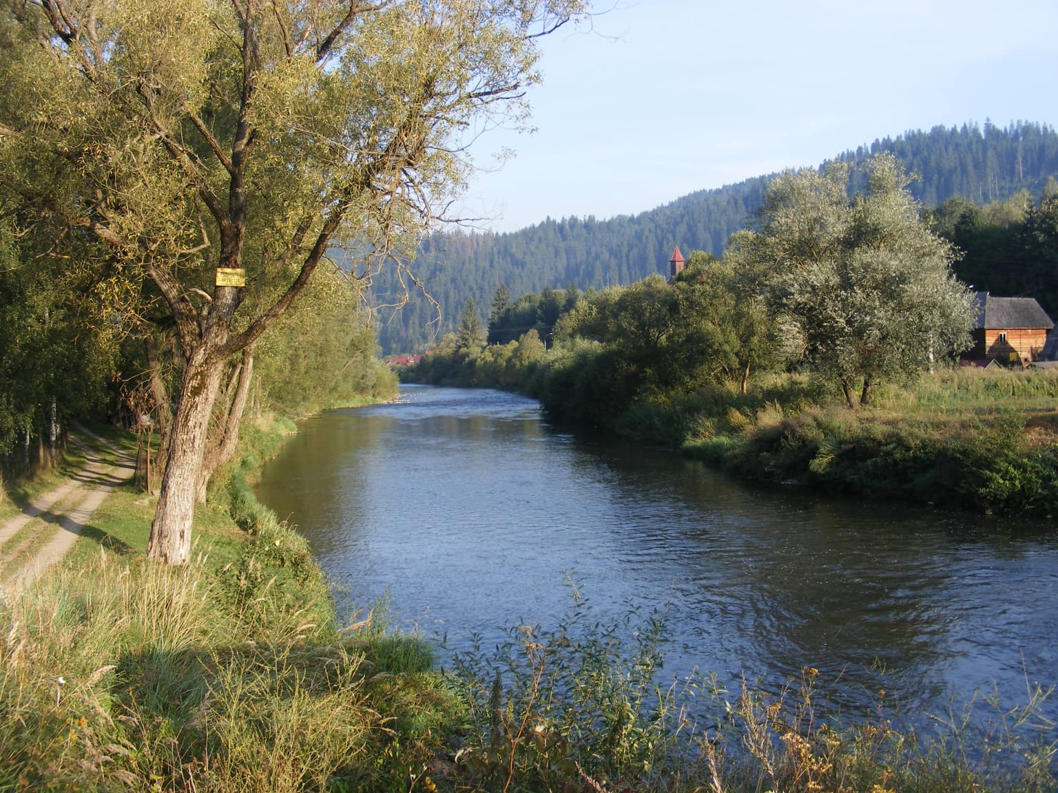
The park is best known for its dramatic river gorge landscape where the Mureș River cuts through a narrow valley flanked by steep volcanic slopes and dense Carpathian forests. It protects a significant corridor of Eastern Carpathian biodiversity, with particularly important avifauna populations including lesser spotted eagles, pygmy owls, Ural owls, capercaillie, and black storks. The combination of riverine habitat, montane forest, and the gorge's microclimate creates favorable conditions for species ranging from European otters in the river to capercaillie in the coniferous stands.

Purple flower with yellow stamens on green stem, blurred background
Close-up of a purple Polemonium coeruleum flower with yellow stamens

Defileul Mureșului Superior Natural Park history and protected-area timeline

The Defileul Mureșului Superior Natural Park was formally established through Romanian Government Decision Number 1143 on September 18, 2007, with the decision published in the Romanian Official Paper Number 691 on October 11, 2007. This designation created a new protected area at the national level, building upon earlier conservation recognition that had identified the area's ecological importance. The park was created to protect the natural values of the upper Mureș River corridor while allowing for sustainable use and management of the landscape. Within the park's boundaries lies the smaller Defileul Deda-Toplița nature reserve, which represents a core zone of heightened protection. The 2007 establishment reflected Romania's broader efforts to expand its network of protected areas and to meet European conservation commitments through the Natura 2000 network, with the park designated as a special avifauna protection area under European Union directives.

Defileul Mureșului Superior Natural Park landscape and geographic character

The landscape of Defileul Mureșului Superior Natural Park is defined by the Mureș River as it flows through a relatively tight gorge in its upper course. The river has carved a valley between steep, often rocky slopes that feature prominent volcanic blocks and outcrops. The terrain rises sharply from the river corridor, creating a landscape of considerable topographic variation within a relatively compact area. The valley floor contains the river channel and associated riparian zones, while the slopes support dense forest cover that transitions from riverine woodlands through deciduous forests to coniferous stands at higher elevations. The combination of the water course, the rocky gorge sections, and the heavily forested slopes creates a landscape of scenic quality that characterizes this portion of the Mureș River valley. The DN15 road follows the river through the park, providing views of the valley and surrounding mountains.

A river flows through a valley bordered by trees, with a dirt path on the left and a small building on the right under a clear sky.
Mureș River flowing through a forested valley near Neagra.

Defileul Mureșului Superior Natural Park ecosystems, habitats, and plant life

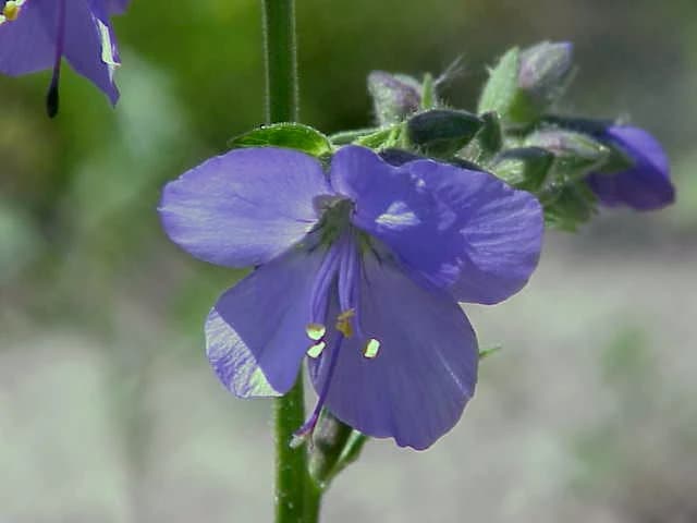
The park encompasses a diverse range of habitat types that reflect its position within the Eastern Carpathians. The forests include mixed mountain forests with species such as beech, ash, hornbeam, birch, and elm, as well as coniferous forests dominated by spruce and fir. Alluvial forests along the river feature willow and alder, while meadows and grasslands occur in appropriate locations. This mosaic of forest types supports a corresponding variety of plant species, including some rare and endemic forms specific to the Carpathian region. The park is designated as a Natura 2000 site, specifically for avifauna protection, acknowledging the importance of these habitats for bird species. The habitat diversity also supports populations of mammals, fish, amphibians, and reptiles that rely on the forest ecosystem, the river corridor, and the transitional zones between different habitat types.

Defileul Mureșului Superior Natural Park wildlife and species highlights

The wildlife of Defileul Mureșului Superior Natural Park reflects the Carpathian character of the protected area. Mammals present include wolf, wild boar, red fox, roe deer, red deer, European pine marten, European badger, and Eurasian otter, the latter indicating good riverine habitat quality. The bird fauna is particularly notable, with the park designated as a special avifauna protection area under European directives. Protected bird species include lesser spotted eagle, booted eagle, Tengmalm's owl, Eurasian eagle-owl, Ural owl, hazel grouse, capercaillie, European nightjar, short-toed snake eagle, white stork, western marsh harrier, montagu's harrier, corncrake, white-backed woodpecker, black woodpecker, three-toed woodpecker, merlin, red-breasted flycatcher, collared flycatcher, pygmy owl, and red-backed shrike. Fish species in the Mureș River include nase, Danube barbel, grayling, chub, gudgeon, and Burbot, supporting both ecological and fisheries value.

Defileul Mureșului Superior Natural Park conservation status and protection priorities

The park's conservation significance derives from its role in protecting a representative portion of Carpathian river gorge ecosystems and the biodiversity they contain. The IUCN Category V designation reflects the park's value as a protected landscape where natural processes continue within a landscape shaped by long-term human presence. The Natura 2000 designation as a Special Avifauna Protection Area specifically recognizes the importance of the area for bird species of European conservation concern, many of which breed in the park's forests. The protection framework aims to maintain the ecological integrity of the forest ecosystems, the river corridor, and the overall landscape while allowing for compatible human uses. The presence of the Defileul Deda-Toplița reserve within the park provides a core protection zone for the most sensitive natural values.

Defileul Mureșului Superior Natural Park cultural meaning and human context

The park lies within the traditional region of Transylvania, in an area with a rich cultural heritage. The surrounding communes contain several historic wooden churches, including the 18th-century wooden church of Saint Nicholas in Răstolița, which is listed as a historical monument. The Toplița Monastery, established in 1924 by Miron Cristea, houses a museum with collections of old church books, icons, and religious objects. These cultural sites, while not within the park itself, are located in the vicinity and contribute to the region's identity. The valley has historically served as a transportation corridor, with the DN15 road following the Mureș River through the park area, connecting communities in this part of Mureș County.

Top sights and standout views in Defileul Mureșului Superior Natural Park

The park's defining feature is its dramatic river gorge landscape where the Mureș River flows between steep volcanic slopes covered in Carpathian forest. The combination of the river corridor, mixed forests, and rocky terrain creates habitat for diverse wildlife including otters in the river, capercaillie in the coniferous forests, and numerous raptor and owl species. The Natura 2000 designation underscores the park's importance for bird conservation in the Eastern Carpathians. The area provides a relatively accessible natural environment along the DN15 road, allowing visitors to experience Carpathian landscape character while passing through the valley.

Best time to visit Defileul Mureșului Superior Natural Park

The park can be visited throughout the year, with each season offering different qualities. The summer months bring full forest cover and warm conditions ideal for exploring the valley and trails. Autumn offers colorful forest foliage and typically quieter conditions. Winter provides a different character with snow-covered slopes, though conditions may be more challenging. Spring brings fresh vegetation and活跃 bird activity. The best time for wildlife observation varies by species, with bird activity highest during the breeding season in spring and early summer.

Park location guide

Geography guide, regional context, and park location map for Defileul Mureșului Superior Natural Park

Defileul Mureșului Superior Natural Park park geography, regions, and map view in Romania
Understand where Defileul Mureșului Superior Natural Park sits in Romania through a broader geographic reading of the surrounding landscape, nearby location context, and its mapped position within the national park landscape.

How Defileul Mureșului Superior Natural Park fits into Romania

Romania is a unitary semi-presidential republic located in Southeast and Central Europe. It borders Ukraine, Hungary, Serbia, Bulgaria, Moldova, and the Black Sea. The country has a population of approximately 19 million and covers an area of 238,397 km². Bucharest is the capital and largest city. Romania joined the European Union in 2007.

Wider geography shaping Defileul Mureșului Superior Natural Park in Romania

Romania lies on the lower course of the Danube River, north of the Balkan Peninsula, and on the northwestern shore of the Black Sea. The terrain is varied, featuring the Carpathian Mountains in the center, the Transylvanian Plateau, the Moldavian Plateau, and plains along the Danube and in the south. The country has a diverse landscape that includes forests, meadows, and wetland areas.

Map view of Defileul Mureșului Superior Natural Park

Use this park location map to pinpoint Defileul Mureșului Superior Natural Park in Romania, understand its exact geographic position, and read its mapped placement within the surrounding landscape more clearly.

Pigeon | © OpenStreetMap contributors

Location context for Defileul Mureșului Superior Natural Park

Mureș County

Visual Guide to Romania's Dramatic River Gorge Terrain, Diverse Habitats, and Eastern Carpathian Protected Landscapes

Defileul Mureșului Superior Natural Park Photos: Explore River Gorge Landscapes and Carpathian Forest Scenery
Immerse yourself in the visual environment of Defileul Mureșului Superior Natural Park through this curated gallery, showcasing the dramatic river gorge, steep volcanic slopes, and dense Carpathian forests. These images provide essential context for understanding the park's unique protected-area character, diverse habitats, and scenic quality in the Eastern Carpathians.

Purple flower with yellow stamens on green stem, blurred background

Black-crowned night-heron bird standing on a branch with green leaves against a clear blue sky

A river flows through a valley bordered by trees, with a dirt path on the left and a small building on the right under a clear sky.

Park atlas

Compare the diverse Carpathian protected landscapes and river gorge geography across Mureș County, Romania.

Discover More Protected Areas and National Parks Near Defileul Mureșului Superior Natural Park
Browse other national parks and protected areas geographically adjacent to Defileul Mureșului Superior Natural Park, tracing the broader Eastern Carpathian range and Mureș County's diverse terrain. Compare their distinct protected landscapes, forest types, and riverine environments to deepen your understanding of regional conservation and mapped park geography.
National park

Călimani National Park: Romania's Premier National Park Protected Landscape

Explore mapped boundaries and regional geographic context.

Uncover the geographic identity of Călimani National Park, a designated national park in Romania. This resource offers detailed insights into its protected landscape, mapped terrain, and surrounding natural context. Navigate through its specific park boundaries and understand how it fits into the wider regional geography, providing a clear atlas-style overview for dedicated discovery.

Area
240.41 km²
Established
2000
IUCN
II
Relief
Mountain
National park

Cheile Bicazului-Hășmaș National Park: Protected Area Geography and Mapped Landscape Identity

Discover Romania's National Park mapped boundaries and regional context.

Cheile Bicazului-Hășmaș National Park represents a vital component of Romania's protected natural areas, offering rich geographic detail for atlas enthusiasts. This national park's mapped landscape and defined protected boundaries provide essential context for understanding regional geography and conservation efforts. Explore the specific identity of this protected terrain and its significance within the broader Romanian atlas.

Area
65.75 km²
Relief
Mountain
Scope
Mixed
Water
Minor water
National park

Rodna Mountains National Park: Explore Protected Landscape and Geographic Atlas

Discover the mapped terrain and protected area context.

Rodna Mountains National Park represents a key protected landscape within Romania, offering rich opportunities for geographic discovery. This page provides detailed insight into its mapped boundaries and how it integrates into the regional terrain. Delve into the structured atlas data to understand the park's protected area status and its significance within the natural geography.

Relief
Mountain
Scope
Terrestrial
Protected landscapeNeamț County

Vânători-Neamț Natural Park: Protected Landscape within Neamț County, Romania

Mapped protected area and regional landscape context.

Vânători-Neamț Natural Park is a designated protected landscape located in Romania's Neamț County. This MoriAtlas entry provides detailed geographic information, focusing on the park's mapped boundaries and its role within the regional atlas of protected natural areas. Understand the park's specific landscape context and its place within the wider geography of Western Moldavia, essential for any structured exploration of Romanian protected lands.

Area
306.31 km²
Established
2003
IUCN
V
Scope
Terrestrial
Watercolor illustration of a mountainous landscape with rolling hills, a river, and green vegetation
Protected landscapeMaramureș County

Maramureș Mountains Natural Park: Protected Landscape and Carpathian Geography

Explore the mapped boundaries and dramatic terrain of Romania's largest nature park.

Delve into the Maramureș Mountains Natural Park, a protected landscape covering extensive tracts of the northern Carpathian Mountains. This page provides detailed geographic context, showcasing the park's mapped boundaries, diverse alpine terrain, and its role within the broader regional geography of Maramureș County. Understand the natural features and protected area significance of this expansive Carpathian wilderness for structured atlas exploration.

Area
1,488.5 km²
Established
2004
IUCN
V
Relief
Mountain
Watercolor illustration of a mountainous landscape with forests, a lake, and distant peaks.
National parkChernivtsi Oblast

Cheremosh National Nature Park: Protected Landscape and Geographic Context in UA

Explore mapped boundaries within Chernivtsi Oblast

Cheremosh National Nature Park represents a vital protected area within Ukraine's Chernivtsi Oblast. This entry offers a structured exploration of the park's geographic identity, focusing on its mapped boundaries and its significance as part of the regional natural landscape. Delve into the terrain and understand how Cheremosh National Nature Park contributes to the mapped geography of western Ukraine, providing a foundation for atlas-based discovery.

Area
71 km²
Established
2009
IUCN
II
Relief
Mountain
National parkVerkhovyna Raion

Verkhovyna National Nature Park: Explore Protected Landscape Geography in Verkhovyna Raion

Discover Ukraine's Verkhovyna National Nature Park mapped terrain.

Verkhovyna National Nature Park represents a vital protected area within the Verkhovyna Raion of Ukraine. This detailed atlas entry focuses on the park's geographic significance, providing insights into its mapped boundaries and its role within the regional landscape context of the Carpathian Mountains. It serves as a focused point for understanding the park's protected status and its place in a structured geographic discovery framework.

Area
120 km²
Established
2010
IUCN
II
Relief
Mountain
National parkChernivtsi Oblast

Vyzhnytsia National Nature Park: Protected National Park Landscape Exploration

Mapped boundaries and regional terrain in Chernivtsi Oblast.

Delve into the specific protected landscape of Vyzhnytsia National Nature Park, a designated national park in Ukraine's Chernivtsi Oblast. This detailed entry provides context on its geographic positioning, mapped natural features, and the surrounding regional terrain, aiding in structured atlas exploration and understanding its significance within the protected areas network.

Area
7,928.4 km²
Established
1995
IUCN
II
Relief
Mountain

Common questions about visiting, size, designation, and location context for Defileul Mureșului Superior Natural Park

Defileul Mureșului Superior Natural Park FAQs for park facts, access, geography, and protected area context
Find quick answers about Defileul Mureșului Superior Natural Park, including protected-area facts, park geography, trail and visitor context, and how the park fits into its surrounding country and regional landscape.
MoriAtlas Explorer

Continue Your Protected Areas Search Across the Global Atlas

Deepen your exploration by continuing the structured search for national parks and protected areas worldwide. Utilize the comprehensive filtering capabilities to compare different conservation landscapes and refine your understanding of global park geography. Discover more about the distribution and characteristics of protected natural areas.

Global natural geography