

Mori Atlas logo
National parkDryandra Woodland National Park

Discover the mapped boundaries and natural terrain of this key Australian national park.

Dryandra Woodland National Park: Australia's Protected Landscape and National Park Geography

Delve into the geography of Dryandra Woodland National Park, an officially designated national park situated within Australia. This page serves as your gateway to understanding the protected landscape, its mapped context, and its significance within the national atlas. Explore the unique natural terrain and boundaries that define this protected area, offering a focused view of its place in Australia's conservation network.

Eucalypt WoodlandThreatened Species RecoveryNoongar HeritageWestern Australian WheatbeltMarsupial ConservationBiodiversity Hotspot

Dryandra Woodland National Park

National park

Park overview

Structured park overview, official facts, and landscape profile for Dryandra Woodland National Park

Dryandra Woodland National Park park facts, protected area profile, and essential visitor context
Review the core facts for Dryandra Woodland National Park, including designation, size, terrain, visitor scale, habitats, and operating context in one park-focused overview.

About Dryandra Woodland National Park

Dryandra Woodland National Park represents a vital conservation enclave within Western Australia's heavily cleared Wheatbelt agricultural region. The park's 17 discrete blocks are interspersed with farmland, creating a archipelago of native vegetation that serves as refuge for wildlife in an otherwise heavily modified landscape. The woodland's position at the biogeographic transition between the Mallee and Avon Wheatbelt regions creates ecological conditions found nowhere else, supporting flora species from both the wetter southwest and the drier interior. The dominant tree species include wandoo, which forms extensive open woodlands across the heavier soils, supplemented by powderbark wandoo and salmon white gum. Jarrah and marri provide additional canopy cover in certain areas, while the understorey features the distinctive rock sheoak and extensive stands of Dryandra species that gave the area its name. The surrounding landscape has been severely affected by salinity issues from historical clearing, making Dryandra's intact woodlands increasingly important as reference ecosystems and genetic reservoirs. The park is managed by the Western Australian Department of Biodiversity, Conservation and Attractions, with visitor facilities including campgrounds at Congelin and Gnaala Mia, the Lions Dryandra Village accommodation, and self-drive touring routes with radio commentaries.

Quick facts and research context for Dryandra Woodland National Park

Dryandra Woodland National Park covers approximately 28,066 hectares across 17 separate blocks in the Western Australian Wheatbelt. Established as a nature reserve in 1976 and elevated to national park status in 2022, the area protects remnant eucalypt woodlands dominated by wandoo, powderbark wandoo, and salmon white gum. The woodland contains over 800 native plant species, including 15 declared priority flora taxa. The park supports significant populations of threatened fauna including the numbat, woylie, red-tailed phascogale, and Carnaby's black cockatoo. The area holds anthropological significance as the traditional country of the Noongar Wiilman people, who know the land as Wilgadjny.

Park context

Deeper park guide and search-rich context for Dryandra Woodland National Park

Dryandra Woodland National Park history, landscape, wildlife, and travel context
Explore Dryandra Woodland National Park through its history, landscape character, ecosystems, wildlife, conservation priorities, cultural context, and seasonal travel timing in a structured park guide built for atlas discovery and search intent.

Why Dryandra Woodland National Park stands out

Dryandra Woodland is best known as a crucial stronghold for Australia's most endangered marsupials, particularly the numbat which has seen its population increase from just 5 individuals recorded in 2018 to 35 by 2020 following feral cat control programs. The woodland protects one of the largest remaining fragments of the original Wheatbelt eucalypt woodlands, with its distinctive wandoo stands and the namesake Banksia ser. Dryandra shrubs. The Barna Mia animal sanctuary provides visitor access to see endangered species including the woylie, bilby, mala, and boodie through nocturnal tours. The park also preserves the cultural heritage of the Noongar people, with documented archaeological sites including an ochre pit used for body decoration and rock art.

Dryandra Woodland National Park history and protected-area timeline

The history of Dryandra reflects the broader patterns of Western Australian land use and conservation evolution. The entire area was classified as state forest in 1903 for the protection of water catchments and the cultivation of wandoo and mallet timber. A significant industry developed in the early 1900s harvesting bark from brown mallet trees, which contained over 40% high-quality tannins suitable for leather production. By the mid-1920s, concerns about over-harvesting emerged, and between 1925 and 1962, plantations were established under the Forests Department, with the Great Depression providing employment for sustenance workers who planted approximately 4,000 hectares of mallet. The industry collapsed by the early 1960s due to world market conditions and competition from synthetic tannins. In 1962, the Australian Academy of Science began reviewing the area's conservation value, leading to recommendations in 1976 that the woodland be managed as a fauna and flora reserve. These recommendations were endorsed by state cabinet, and since then the area has been managed primarily for conservation while maintaining limited commercial timber operations. A comprehensive management plan in 1995 formally adopted the name Dryandra Woodland. The area was declared a national park on 17 January 2022, recognizing its elevated conservation significance.

Dryandra Woodland National Park landscape and geographic character

The Dryandra Woodland sits within the southwestern province of the Yilgarn craton, an ancient geological plateau composed mainly of granite with dolerite intrusions and laterite caps. Past weathering has produced the gently undulating countryside characteristic of the area. The landscape comprises open eucalypt woodlands on laterite soils, with the characteristic wandoo trees creating a park-like appearance across much of the reserve. The terrain is generally flat to subtly undulating, with variation created by low ridges and seasonal watercourses. The individual blocks that make up the woodland range dramatically in size from 87 hectares to over 12,000 hectares, connected by varying degrees of vegetation corridors through the surrounding agricultural matrix. Some road reserves and remnant vegetation strips provide movement corridors for wildlife between the woodland islands. The landscape contrasts sharply with the cleared farmland that surrounds the reserve, making the woodland patches appear as green oases in an otherwise modified terrain.

Dryandra Woodland National Park ecosystems, habitats, and plant life

The ecological character of Dryandra Woodland is defined by its position at the interface between two major biogeographic regions, creating a transitional flora that includes elements from both the wetter jarrah forests and the drier wheatbelt. The woodland supports over 800 native plant species, with 15 declared priority species under Western Australia's conservation legislation. The tree layer is dominated by several eucalypt species, with wandoo forming the most extensive stands across the laterite soils. Powderbark wandoo and salmon white gum provide diversity in certain areas, while jarrah and marri appear in locations with deeper soils. The understorey features the distinctive rock sheoak and the genus formerly known as Dryandra, now reclassified as Banksia ser. Dryandra, which includes species such as golden dryandra and prickly dryandra. This botanical diversity supports a corresponding richness of fauna, particularly mammals that have evolved tolerance to the toxic compounds found in some native plants, particularly the Gastrolobium species that produce sodium fluoroacetate.

Dryandra Woodland National Park wildlife and species highlights

Dryandra Woodland supports exceptional concentrations of threatened Australian fauna, making it one of the most important conservation areas in Western Australia. The park holds major populations of three nationally endangered marsupials: the woylie, the red-tailed phascogale, and more than 50% of the total known numbat population. The numbat, an insectivorous marsupial formerly widespread across southern Australia, has shown remarkable recovery in Dryandra following intensive feral cat control, with numbers rising from 5 individuals in 2018 to 35 by 2020. Other threatened species include the bilby, mala, boodie, and western barred bandicoot, which are protected within the Barna Mia sanctuary and viewable on nocturnal tours. The avifauna includes at least 98 species, notably the vulnerable malleefowl and the endangered Carnaby's black cockatoo. Amphibian populations reflect the woodland's transition-zone position, with several species at the eastern or western limits of their range. The western marsh frog is particularly associated with the western Darling Range fringe of the park.

Dryandra Woodland National Park conservation status and protection priorities

Dryandra Woodland represents one of Western Australia's most significant conservation achievements, demonstrating successful recovery of critically endangered species through targeted management. The Western Shield predator control program has been instrumental in enabling threatened marsupial populations to rebuild, with particularly dramatic results for the numbat. The park's conservation value is reinforced by its listing on the Register of the National Estate, recognizing its outstanding natural heritage significance. The woodland serves as a genetic reservoir and reference ecosystem in a landscape severely impacted by salinity and vegetation clearing. Conservation challenges include managing the fragmented nature of the 17 separate blocks, maintaining wildlife corridors through agricultural land, and balancing visitor access with sensitive species protection. The park's management plan Vision extends 100 years, acknowledging the long-term commitment required to restore and maintain biodiversity in this modified landscape.

Dryandra Woodland National Park cultural meaning and human context

The Dryandra area holds deep significance for the Noongar people, specifically the Wiilman subgroup, who have inhabited the region for thousands of years. The woodland is known to the Noongar as Wilgadjny, and five important archaeological sites have been documented within the complex, including an ochre pit used for body decoration and rock art sites. One Noongar elder born in 1910 described the ochre pit as a sacred place to be avoided at night. Other known cultural sites include artefact scatters, stone arrangements, and scarred trees where bark was removed for canoes or shelters. The area remains important for cultural transmission, and in 1995 the Department of Environment and Conservation explored permitting traditional hunting and camping activities to pass cultural knowledge to younger community members, subject to sustainable management. Full archaeological survey of the woodland has not yet been completed, suggesting additional sites may remain undocumented.

Top sights and standout views in Dryandra Woodland National Park

The defining highlights of Dryandra Woodland include the successful recovery of numbat populations through intensive feral predator management, the Barna Mia sanctuary offering rare opportunities to observe endangered marsupials including the woylie and bilby, the distinctive wandoo woodlands representing the largest remaining fragments of pre-clearing Wheatbelt vegetation, and the park's transition-zone ecology supporting both southwest and semi-arid species. The self-drive touring experience with FM radio commentaries provides an engaging way to understand the woodland's ecology and history, while the various bushwalking trails allow deeper exploration. The Noongar cultural heritage adds another dimension of significance, with documented ochre pits and rock art demonstrating continuous human connection to the landscape. The elevation to national park status in 2022 reflects the recognition of this area as a premier conservation site in the Australian landscape.

Best time to visit Dryandra Woodland National Park

The optimal time to visit Dryandra Woodland aligns with the cooler months from late autumn through early spring, typically May through October, when daytime temperatures are mild and the woodland remains accessible. The Mediterranean climate brings seven to eight dry months each year, with summer conditions potentially hot and dry. Winter and early spring bring welcome rainfall that supports wildlife viewing as animals become more active around water sources. The numbats and other nocturnal mammals are most readily observed during the Barna Mia nocturnal tours, which operate on alternate evenings by appointment. Birdwatching is particularly rewarding during the spring breeding season when species activity peaks. The summer months should be approached with caution due to fire risk and higher temperatures, though the park remains open. The self-drive touring experience is enjoyable year-round, though the radio commentaries are most informative during the cooler periods when visitors can comfortably spend time at each stop.
Park location guide

Geography guide, regional context, and park location map for Dryandra Woodland National Park

Dryandra Woodland National Park park geography, regions, and map view in Australia
Understand where Dryandra Woodland National Park sits in Australia through a broader geographic reading of the surrounding landscape, nearby location context, and its mapped position within the national park landscape.

How Dryandra Woodland National Park fits into Australia

Australia is a constitutional monarchy and federal parliamentary democracy comprising six states and ten territories. With a population of nearly 28 million, it is one of the world's most urbanised countries, with most people concentrated on the eastern seaboard. The country has a high Human Development Index and is known for its cultural diversity, ancient Aboriginal heritage, and unique wildlife.

Wider geography shaping Dryandra Woodland National Park in Australia

Australia occupies the entire Australian continent, the island of Tasmania, and numerous smaller islands. It is the world's flattest and driest inhabited continent, featuring vast deserts in the interior (the Outback), tropical rainforests along the eastern coast, and a coastline bordering the Indian and Pacific Oceans.

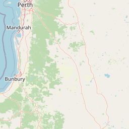
Map view of Dryandra Woodland National Park

Use this park location map to pinpoint Dryandra Woodland National Park in Australia, understand its exact geographic position, and read its mapped placement within the surrounding landscape more clearly.

Pigeon | © OpenStreetMap contributors

Location context for Dryandra Woodland National Park

Western AustraliaWheatbelt
Park atlas

Explore similar eucalypt woodlands and unique conservation landscapes across Western Australia's Wheatbelt region.

Discover Other National Parks and Protected Areas Near Dryandra Woodland National Park
Continue your exploration beyond Dryandra Woodland National Park to browse other protected areas within Western Australia's distinctive Wheatbelt region, including additional eucalypt woodlands and semi-arid environments. Compare park geography and conservation landscapes to trace the spread of crucial ecological remnants and understand regional biodiversity patterns.
National parkWheatbelt

Wandoo National Park National Park: Explore Protected Landscape and Geographic Boundaries

Discover Wheatbelt's mapped protected area.

Wandoo National Park is a designated national park situated in Australia's Wheatbelt region, offering a focal point for understanding protected landscapes. This page provides detailed geographic context for the park, highlighting its mapped boundaries and its significance within the broader regional geography. Users can explore the park's protected area status and its contribution to the mapped natural landscape of Western Australia, serving as a key entry point for atlas-based discovery.

Area
463.68 km²
Established
2004
IUCN
II
Climate
Temperate
National parkWestern Australia

Serpentine National Park: Waterfall & Wildflower Protected Landscape in Western Australia

Mapped geography, waterfall terrain, and spring bloom discovery.

Serpentine National Park is a protected national park located in Western Australia, approximately 55 kilometers southeast of Perth. It is celebrated for its prominent Serpentine Falls, a multi-tiered cascade that forms a popular natural pool, and its stunning spring wildflower season. The park showcases the undulating terrain of the Darling Scarp, featuring jarrah and marri woodlands. This park offers a distinct opportunity for atlas-based exploration of protected landscapes, with a focus on its unique waterfall features and vibrant botanical displays.

Area
43.87 km²
Established
1957
IUCN
II
Relief
Upland
National parkWestern Australia

Helena National Park: National Park with Regional Geographic Context in Western Australia

Mapping protected area boundaries and natural landscapes.

Helena National Park represents a significant protected area within the expansive geography of Western Australia. This page facilitates detailed exploration of its national park status, offering insights into its mapped boundaries and the regional landscape context. Discover how Helena National Park contributes to the protected land atlas of Western Australia, providing a specific focus for geographic understanding and park exploration.

Area
122.55 km²
Established
2004
Relief
Upland
Climate
Mediterranean
National parkPerth metropolitan region

Midgegooroo National Park: Jarrah Forest Protected Landscape and Regional Geography

Explore its mapped boundaries and terrain near Perth.

Midgegooroo National Park offers a distinct protected landscape characterized by its expansive jarrah forest terrain within the Perth metropolitan region. This national park provides valuable context for understanding regional geography, mapped natural features, and the distribution of protected lands. Explore the park's unique topography and conservation boundaries, vital for comprehensive atlas-based geographic discovery.

Area
24.92 km²
Established
2004
IUCN
II
Relief
Upland
National parkWestern Australia

Wellington National Park: Protected Jarrah Forest & Collie River Landscape

Explore the mapped boundaries and regional geography.

Wellington National Park offers a deep dive into Western Australia's protected landscapes, characterized by extensive old-growth jarrah forests and the scenic Collie River valley. This national park provides a vital study of the region's unique geography, mapped terrain, and ecological significance within the Yilgarn craton. Understand the park's protected area identity and its place in the wider natural context of Western Australia through its detailed landscape features.

Area
170 km²
Established
2000
IUCN
II
Visitors
212K annual
National parkWestern Australia

Korung National Park: Protected Landscape and Map Context in Western Australia

Discover its unique dual bioregion geography.

Korung National Park is a protected national park in Western Australia, noted for its position along the Darling Scarp overlooking the Swan Coastal Plain. This reserve provides accessible natural experiences and showcases the ecological transition between two major southwest Australian bioregions. Its mapped landscapes offer a clear example of regional protected area planning and its importance for biodiversity conservation in the Perth metropolitan area.

Area
63.54 km²
Established
2004
IUCN
II
Relief
Mixed relief
National parkWestern Australia

Beelu National Park: Exploring Western Australia's Protected Jarrah-Marri Forest Landscape

Mapped Geographic Context & Natural Terrain Discovery

Beelu National Park, situated in Western Australia's Darling Range, offers an immersive experience within old-growth jarrah-marri forests. This protected area provides a vital glimpse into the region's natural landscapes, characterized by rolling hills and the Helena River valley. Users can explore the park's geographic setting, its mapped boundaries, and the unique ecological context it preserves. It stands as a significant natural reserve contributing to the understanding of Western Australia's conservation efforts and diverse terrain.

Area
46.17 km²
Established
1995
IUCN
II
Relief
Highland
National parkWestern Australia

Yalgorup National Park: National Park Protected Landscape and Geographic Atlas Entry

Explore the mapped terrain and regional natural context of this Western Australian park.

Yalgorup National Park is a key protected area in Western Australia, designated as a national park to preserve its natural landscape and geographic features. This MoriAtlas entry provides structured insight into its mapped boundaries and regional context, contributing to a broader understanding of Western Australia's diverse geography. It serves as a vital component for exploring the natural landscapes and protected areas that define this significant Australian region, offering a foundation for detailed atlas-based discovery.

Area
131.41 km²
Established
1966
IUCN
II
Relief
Lowland

Common questions about visiting, size, designation, and location context for Dryandra Woodland National Park

Dryandra Woodland National Park FAQs for park facts, access, geography, and protected area context
Find quick answers about Dryandra Woodland National Park, including protected-area facts, park geography, trail and visitor context, and how the park fits into its surrounding country and regional landscape.
MoriAtlas Explorer

Continue Your Protected Areas Search Across the Global Atlas

Deepen your exploration by continuing the structured search for national parks and protected areas worldwide. Utilize the comprehensive filtering capabilities to compare different conservation landscapes and refine your understanding of global park geography. Discover more about the distribution and characteristics of protected natural areas.

Global natural geography