Mori Atlas logo
Nature reserveEemmeer & Gooimeer Zuidoever

Mapping the shallow freshwater margins and ecological corridors of this Dutch lake region

Eemmeer & Gooimeer Zuidoever: A Protected Wetland Landscape and Natura 2000 Nature Reserve

Eemmeer & Gooimeer Zuidoever functions as a critical nature reserve along the southern shores of two adjoining lakes in the central Netherlands. Spanning the interface between the reclaimed Flevoland polders and the older mainland, this Natura 2000 site protects 1,584 hectares of shallow littoral zones, marshes, and reed beds. It serves as a significant avian habitat within the larger Zuiderzee wetland network, bridging the provinces of Flevoland, North Holland, and Utrecht through its diverse freshwater geography.

Natura 2000lakelake-fringeBirds Directivemarshfreshwater

Eemmeer & Gooimeer Zuidoever

Nature reserve

Park overview

Structured park overview, official facts, and landscape profile for Eemmeer & Gooimeer Zuidoever

Eemmeer & Gooimeer Zuidoever park facts, protected area profile, and essential visitor context

Review the core facts for Eemmeer & Gooimeer Zuidoever, including designation, size, terrain, visitor scale, habitats, and operating context in one park-focused overview.

About Eemmeer & Gooimeer Zuidoever

Eemmeer & Gooimeer Zuidoever is a designated Natura 2000 protected landscape located along the southern shores of the Eemmeer and Gooimeer, two large freshwater lakes in the central Netherlands. The area consists of two separate components, the eastern part lying within the Eemmeer and the western part within the Gooimeer, collectively forming a narrow but ecologically important band of protected shoreline and shallow water.

Geographically, the site stretches across three provinces: Flevoland to the north and east, North Holland along the western shore, and Utrecht where the lakes meet the older mainland. Towns bordering or near the reserve include Almere, Blaricum, Bunschoten, Eemnes, Huizen, and Zeewolde. This multi-province distribution reflects the transitional position of the lakes, sitting at the seam between the engineered Flevoland polders and the pre-existing cultural landscape of the Gooi region and the Eem valley.

The lakes themselves are relatively young in their present form. They originated as remnants of the Zuiderzee, the inland sea that once dominated this part of the Netherlands, and became freshwater bodies after the construction of the Afsluitdijk and the reclamation of southern Flevoland in 1968. Eemmeer & Gooimeer Zuidoever therefore represents a specific example of how newly enclosed waters can be integrated into formal nature conservation frameworks once surrounding land use stabilizes.

Protected under the European Birds Directive and designated as a Natura 2000 area in late 2009, the reserve is classified in the lakes and marshes category. It is part of a broader constellation of lake-fringe sites in the southern Flevoland region, linking ecologically with neighboring reserves such as the Oostvaardersplassen, the Veluwerandmeren, and the Arkemheen polder. Within that network, Eemmeer & Gooimeer Zuidoever contributes one of the more open-water-defined stretches of protected shoreline.

Quick facts and research context for Eemmeer & Gooimeer Zuidoever

Eemmeer & Gooimeer Zuidoever is a Dutch Natura 2000 site with the official area number 77 and the European site code NL9802035. It is classified as a lake and marsh habitat type and is protected under the European Birds Directive (Vogelrichtlijn).

The area covers approximately 15.84 km² and sits across three provinces: Flevoland, North Holland, and Utrecht. It consists of two components, the eastern Eemmeer portion and the western Gooimeer Zuidoever portion, both located in the southern fringes of their respective lakes. The site was formally designated on 23 December 2009.

Protection and recognition

Review documented terrestrial protection scope and conservation management context

Eemmeer & Gooimeer Zuidoever Protection Status and Recognition Data

Eemmeer & Gooimeer Zuidoever maintains a documented terrestrial protection scope within regional conservation records. Protected area data compiles official management details and international recognition parameters for structured geographic analysis.

Protection details

Protection scope
Terrestrial
Transboundary protection
No
Park context

Deeper park guide and search-rich context for Eemmeer & Gooimeer Zuidoever

Eemmeer & Gooimeer Zuidoever history, landscape, wildlife, and travel context

Explore Eemmeer & Gooimeer Zuidoever through its history, landscape character, ecosystems, wildlife, conservation priorities, cultural context, and seasonal travel timing in a structured park guide built for atlas discovery and search intent.

Why Eemmeer & Gooimeer Zuidoever stands out

Eemmeer & Gooimeer Zuidoever is best known for its bird-rich southern lake shores, which form part of the larger wetland tapestry surrounding the Flevoland polders. The combination of open freshwater, shallow littoral zones, and marshy margins makes it a significant site under the European Birds Directive. The two-lake structure of the reserve is a defining feature: the Eemmeer component to the east and the Gooimeer Zuidoever component to the west together create a continuous protected shoreline along the boundary between reclaimed land and the older mainland. This makes the area a key element in the ecological network of central Netherlands lake districts.

Eemmeer & Gooimeer Zuidoever history and protected-area timeline

The lake system that contains Eemmeer & Gooimeer Zuidoever was shaped by twentieth-century hydraulic engineering. The Eemmeer and Gooimeer originated as southern arms of the Zuiderzee, the brackish inland sea that historically reached deep into the Dutch interior.

The decisive change came with the closure of the Zuiderzee by the Afsluitdijk in 1932 and the subsequent reclamation of southern Flevoland in 1968. As the southern polder was drained, the remaining water bodies were cut off from the open sea and gradually became freshwater lakes. The southern shores of these lakes, which now form the protected area, were thus defined both by natural lake formation and by the final contours of the Flevoland reclamation works.

Recognition of the ecological importance of these lake margins came later. Eemmeer & Gooimeer Zuidoever was formally designated as a Natura 2000 site on 23 December 2009, receiving European site code NL9802035 and Natura 2000 area number 77. Its designation under the Birds Directive reflected a growing understanding that newly created Dutch lake districts had significant value for breeding, staging, and wintering waterbirds. Since then, the site has functioned as a fixed reference point within the Dutch Natura 2000 network.

Eemmeer & Gooimeer Zuidoever landscape and geographic character

The landscape of Eemmeer & Gooimeer Zuidoever is dominated by open water and the gentle transition from lake to land. The protected area consists of shallow water zones, littoral fringes, and the immediate shoreline of the Eemmeer in the east and the Gooimeer in the west.

The two lake basins are broad and shallow rather than dramatic, typical of polder-bounded Dutch lakes. Their southern edges, where the site lies, are framed by the straight engineered shoreline of southern Flevoland to the north and the somewhat more varied older shoreline of the Gooi region and the Eem valley to the south. The result is a landscape defined by horizon, water, reed, and the subtle distinction between reclaimed land and natural lake margin.

Because the lakes formed after the enclosure of the Zuiderzee, the scenery carries visible traces of large-scale land management: long straight dikes, polder boundaries, and the engineered profile of the Flevoland coast. Within that geometric framework, the reserve protects the narrower, more ecologically dynamic zone where the open lake meets fringe marshes and adjoining farmland.

Eemmeer & Gooimeer Zuidoever ecosystems, habitats, and plant life

Ecologically, Eemmeer & Gooimeer Zuidoever belongs to the lake and marsh habitat category of the European Natura 2000 system. Its character is defined by freshwater open water, shallow littoral zones, and fringing marshy vegetation along the southern shorelines.

The site complements the broader ecological pattern of the southern Flevoland lake district, where newly enclosed waters have gradually developed freshwater habitats of value to waterbirds. Reed belts, soft shorelines, and shallow bays create transitional zones between open lake and adjacent polder or older cultural land, supporting species that depend on these interface habitats.

Its habitat profile makes the area especially relevant in the Dutch context of bird protection, where lake margins often carry higher conservation interest than the open water itself. The protected area thus acts as an ecological link between the open waters managed by Rijkswaterstaat and the marshland reserves that lie further inland.

Eemmeer & Gooimeer Zuidoever wildlife and species highlights

Eemmeer & Gooimeer Zuidoever is protected under the European Birds Directive, which makes waterbirds the central focus of its wildlife significance. The combination of open freshwater, shallow margins, and adjacent marsh belts provides habitat for breeding, resting, and wintering bird populations in one of the more intensively used sections of the Dutch lake district.

The reserve sits within the southern Flevoland lake corridor, where neighboring protected sites support large populations of ducks, geese, and other water-associated species. While the specific fauna inventory is shaped by ongoing monitoring rather than by a single static species list, the site's role within the European bird protection network indicates its importance for migratory and resident waterfowl using the central Netherlands.

Its ecological value for birds is strongly linked to its position as a southern lake-fringe reserve, providing both shoreline habitat and a stepping stone between the open IJsselmeer system and the inland lakes and polders.

Eemmeer & Gooimeer Zuidoever conservation status and protection priorities

Eemmeer & Gooimeer Zuidoever was designated as a Dutch Natura 2000 area on 23 December 2009 and is protected specifically under the European Birds Directive. This legal framework obliges the Netherlands to maintain the area in a condition favorable for qualifying bird species, and places the site within the formal European ecological network.

The reserve contributes to the conservation of freshwater lake and marsh habitats in the southern Flevoland region. By protecting the southern shorelines of the Eemmeer and the western shorelines of the Gooimeer, it helps ensure that the interface between open water and adjacent land remains ecologically functional, even in a heavily engineered landscape.

Its conservation importance is best understood in network terms. The site does not stand alone; it forms part of a cluster of lake-fringe and marsh reserves in central Netherlands, including sites such as the Oostvaardersplassen, the Veluwerandmeren, and the Arkemheen polder. Together these reserves distribute protection across the water-land transitions of the Flevoland polder belt.

Top sights and standout views in Eemmeer & Gooimeer Zuidoever

The defining highlight of Eemmeer & Gooimeer Zuidoever is its dual-lake structure, with one protected component in the Eemmeer and another in the Gooimeer Zuidoever, linked through their shared role as southern lake-fringe habitat. This structure reflects both geography and history, given that both lakes originated as arms of the former Zuiderzee.

Another highlight is the site's multi-province distribution, spanning Flevoland, North Holland, and Utrecht, and connecting communities such as Almere, Blaricum, Bunschoten, Eemnes, Huizen, and Zeewolde. This makes it a notable example of cross-regional ecological cooperation in Dutch nature conservation.

Finally, the late 2009 designation of the area as Natura 2000 site 77 under the Birds Directive gives the reserve a clear modern conservation role, anchored in European habitat and species protection frameworks rather than purely national policy.

Best time to visit Eemmeer & Gooimeer Zuidoever

Eemmeer & Gooimeer Zuidoever is a lake-fringe reserve whose character shifts with the seasons in ways typical of Dutch freshwater lakes. Spring and early summer bring activity in the reed belts and shallow bays, with breeding waterbirds using the milder conditions along the southern shores.

Autumn and winter often increase the area's significance for waterbirds, as migrating and wintering species concentrate on the relatively open, unfrozen margins of the Eemmeer and Gooimeer. The wide horizons and low light over the flat lake landscape are particularly atmospheric during the cooler months, when the openness of the water dominates the view.
Monthly climate preview

Long-term representative point measurements for annual temperature and precipitation patterns

Eemmeer & Gooimeer Zuidoever Climate Normals and Temperature Rhythms

Representative coordinate records trace monthly temperature ranges from subzero winter minimums to warm summer maximums alongside consistent daily precipitation rates. Analyzing complete monthly climate statistics reveals full baseline normals across the protected area.
Annual mean10 °C
2 °C18 °C
Jan
Feb
Mar
Apr
May13°
Jun16°
Jul18°
Aug18°
Sep15°
Oct11°
Nov
Dec
Warmest month
July

17.9 °C

Coolest month
January

2.5 °C

Wettest month
December

2.6 mm/day

Driest month
April

1.4 mm/day

Park location guide

Geography guide, regional context, and park location map for Eemmeer & Gooimeer Zuidoever

Eemmeer & Gooimeer Zuidoever park geography, regions, and map view in Netherlands

Understand where Eemmeer & Gooimeer Zuidoever sits in Netherlands through a broader geographic reading of the surrounding landscape, nearby location context, and its mapped position within the national park landscape.

How Eemmeer & Gooimeer Zuidoever fits into Netherlands

The Netherlands is a low-lying coastal country in Northwestern Europe, famous for its extensive dike and canal systems that reclaim land from the sea. It consists of twelve provinces and is known for tulips, windmills, and cycling culture. The country is a founding member of the European Union with Amsterdam as its capital and The Hague as the seat of government.

Wider geography shaping Eemmeer & Gooimeer Zuidoever in Netherlands

The Netherlands is located in Northwestern Europe along the North Sea coastline to the north and west. It borders Germany to the east and Belgium to the south. The country is notably flat, with a significant portion of its territory lying below sea level, protected by dikes and dune systems. It consists of twelve provinces and also includes overseas municipalities in the Caribbean.

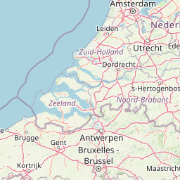
Map view of Eemmeer & Gooimeer Zuidoever

Use this park location map to pinpoint Eemmeer & Gooimeer Zuidoever in Netherlands, understand its exact geographic position, and read its mapped placement within the surrounding landscape more clearly.

Pigeon | © OpenStreetMap contributors

Location context for Eemmeer & Gooimeer Zuidoever

Flevoland
Park atlas

Compare surrounding wetland reserves and regional lake-fringe habitats across the central Netherlands.

Parks Near Eemmeer and Gooimeer Zuidoever and Related Protected Landscapes

Browsing other parks near Eemmeer and Gooimeer Zuidoever reveals a connected network of wetland reserves and shallow lake habitats across the central Netherlands. Expanding the geographic comparison highlights regional conservation patterns along adjacent polder borders and freshwater shorelines.
Nature reserveNetherlands
About 7.7 km away#1 closest

Southeast

Arkemheen Nature Reserve: Geography and Protected Landscape Context in the Netherlands

Mapping medieval polder patterns and wetland bird habitats.

Arkemheen is a significant nature reserve in the Netherlands characterized by a flat, open polder landscape and historic fourteenth-century agricultural patterns. The area offers a distinct ecological profile, integrating freshwater border lakes with saline-influenced grasslands that support an internationally recognized population of meadow and wetland birds.

Area
14.3 km²
Established
1356
Relief
Lowland
Climate
Temperate
National parkFlevoland
About 13 km away#2 closest

North

Nieuw Land National Park: Mapped Wetland Landscape on Flevoland's Reclaimed Land

Protected area geography and ecological discovery in the Netherlands

Nieuw Land National Park offers a distinctive protected landscape forged on land recently reclaimed from the sea in the Dutch province of Flevoland. This national park is characterized by its vast expanse of wetlands, artificial islands like the Marker Wadden, and critical importance for migratory bird populations. Delve into the park's geographic context and mapped features to understand its unique conservation value and role within the wider European atlas of protected areas.

Area
289 km²
Established
2018
IUCN
II
Relief
Lowland
Nature reserveFlevoland
About 13 km away#3 closest

North

Markermeer & IJmeer Nature Reserve: Mapping Dutch Freshwater and Polder Landscapes

A vast protected lake system shaped by historic water engineering

Spanning the distance between Flevoland and North Holland, Markermeer & IJmeer represents a significant freshwater protected area. The landscape features large lake basins framed by dike systems and recent island developments, offering a prime example of Dutch wetland geography and managed water ecosystems.

Area
79.553 km²
Established
2009
Relief
Lowland
Climate
Temperate
A horizontal watercolor painting depicting a wetland landscape with grassy foreground, bare skeletal trees, and rolling green hills under a soft, pale sky.
Nature reserveFlevoland
About 14 km away#4 closest

North

Oostvaardersplassen Nature Reserve: Mapped Geography and Protected Area Context

Explore the marshland and polder terrain in Flevoland, Netherlands

Oostvaardersplassen represents a landmark in modern Dutch conservation, covering a 5,600-hectare mosaic of mudflats, reed beds, and willow thickets. This nature reserve, located between Almere and Lelystad, demonstrates the evolution of a young reclaimed landscape. It provides an essential habitat for marsh birds and large herbivores within the Nationaal Park Nieuw Land region, offering a distinct study in polder-based ecological management and wetland geography.

Area
56 km²
Established
1974
Relief
Lowland
Climate
Temperate
Nature reserveFlevoland
About 14 km away#5 closest

Northwest

Lepelaarplassen Nature Reserve: Protected Polder Wetlands and Marshland Geography

Ecologically significant wetland habitats in Flevoland

Lepelaarplassen is a protected wetland reserve situated on the edge of the young Flevoland polder. Featuring a blend of excavated lakes, willow marshes, and expansive reed fringes, the area provides essential habitat for colonial breeding birds and migratory species. This detailed look covers the landscape structure and regional geography of one of the most vital wetland zones along the Oostvaardersdijk.

Area
5 km²
Established
1971
Relief
Lowland
Access
Moderate access
Protected areaNetherlands
About 19 km away#6 closest

East

Veluwe: A Comprehensive Geographic Atlas of the Central Netherlands Protected Area

Glacial moraines, heathlands, and inland sand systems

Investigate the Veluwe, a premier protected area in the Gelderland province characterized by its historic push moraines and extensive ecological zones. The region encompasses significant sand drift complexes, dense woodlands, and vital spring-fed streams, offering a clear view of the diverse natural terrain found throughout the central Netherlands.

Area
1,000 km²
Relief
Upland
Climate
Temperate
Access
Easy access
A watercolor landscape painting of a calm, shallow body of water surrounded by grassy, low-lying shores and soft, distant hills under a pale, white sky.
Protected areaNetherlands
About 29 km away#7 closest

North

IJsselmeer: Geography and Protected Wetland Mapping of the Netherlands

Engineered freshwater landscapes and polder geography

The IJsselmeer acts as the central freshwater reservoir for the Netherlands, providing a expansive, horizon-dominated landscape shaped by the Afsluitdijk. As an internationally recognized wetland, it supports diverse waterbird populations within its intricate system of dikes, former tidal channels, and emerging nature islands. This protected area stands as a definitive example of large-scale, adaptive hydraulic management in a low-lying coastal nation.

Area
1,133 km²
Established
1932
Relief
Lowland
Climate
Temperate
Watercolor landscape showing green hills, forests, and a small stream with grassy patches
National parkUtrecht Province
About 30 km away#8 closest

South

Utrechtse Heuvelrug National Park: Mapped Protected Landscape and Geographic Atlas

Discover Utrecht Province's glacial ridge and diverse natural terrain.

Utrechtse Heuvelrug National Park is a significant protected natural area located in Utrecht Province, renowned for its unique glacial ridge topography. This entry provides detailed information about its mapped boundaries, diverse landscapes including heathlands and forests, and its importance as an ecological corridor within the Netherlands. Explore the park's distinct geography and its role in regional conservation through our structured atlas view.

Area
100 km²
Established
2003
IUCN
II
Visitors
1M annual

Common questions about visiting, size, designation, and location context for Eemmeer & Gooimeer Zuidoever

Eemmeer & Gooimeer Zuidoever FAQs for park facts, access, geography, and protected area context

Find quick answers about Eemmeer & Gooimeer Zuidoever, including protected-area facts, park geography, trail and visitor context, and how the park fits into its surrounding country and regional landscape.
MoriAtlas Explorer

Continue Your Protected Areas Search Across the Global Atlas

Deepen your exploration by continuing the structured search for national parks and protected areas worldwide. Utilize the comprehensive filtering capabilities to compare different conservation landscapes and refine your understanding of global park geography. Discover more about the distribution and characteristics of protected natural areas.

Global natural geography