Mori Atlas logo
Nature reserveArkemheen

A rare, historically intact polder landscape featuring saline-influenced meadows and crucial bird protection areas.

Arkemheen Nature Reserve: Mapping the Medieval Polder Landscapes and Protected Wetlands of the Netherlands

(Natura 2000-gebied Arkemheen)

Arkemheen represents an exceptional protected landscape in the Netherlands, defined by its flat, open polder terrain and exceptionally preserved medieval parceling patterns. This nature reserve serves as an vital sanctuary for meadow birds and waterfowl, showcasing a mosaic of peat meadows, reed marshes, and historic dike-break kolks along the border lakes of the former Zuiderzee.

polder landscapepeat meadowsNatura 2000birds directiveImportant Bird Areamedieval reclamation

Arkemheen

Nature reserve

Park overview

Structured park overview, official facts, and landscape profile for Arkemheen

Arkemheen park facts, protected area profile, and essential visitor context

Review the core facts for Arkemheen, including designation, size, terrain, visitor scale, habitats, and operating context in one park-focused overview.

About Arkemheen

Arkemheen occupies a flat wedge of reclaimed land along the former southern shore of the Zuiderzee, where lowland streams descending from the Veluwe and the Gelderse Vallei once met the sea. After reclamation, these former delta fringes became part of a remarkably open agricultural landscape that has never been subject to land consolidation. As a result, the long, narrow medieval parcels and characteristic drainage pattern of the fourteenth-century polders remain visible in the modern countryside, giving Arkemheen a rare continuity between its early reclamation history and its present agricultural use.

The landscape is shaped by water in multiple ways. The outer edge of the area is defined by the Zeedijk, the old sea dike, while inside it the land falls away into broad, low-lying meadows that contrast with the more wooded surroundings of the Veluwe just to the east. Along the dike, old dike-break lakes (kolken) and fragments of reed marsh survive as reminders of repeated breaches of the seawall, the last of which occurred during a severe storm and high water event in 1916. The freshwater border lakes on the western side underpin the saline character of some of the innermost grasslands, lending the polder a unique combination of freshwater, brackish and dry meadow habitats within a small area.

Conservation management in Arkemheen is structured around its status as a Natura 2000 site under the Birds Directive. The combination of state-owned land managed by Natuurmonumenten and Staatsbosbeheer, together with private farmland managed under agri-environmental agreements, has turned the polder into a working agricultural landscape that simultaneously functions as a major bird protection area. Nest protection measures for breeding waders and shallow water management for wintering waterfowl are typical of the practical conservation approach here, and a public visitor center at the steam pumping station Hertog Reijnout provides a focal point for visitors interested in both the engineering heritage and the natural values of the area.

Quick facts and research context for Arkemheen

Arkemheen is a Natura 2000 site (area number 56) classified under the heading of lakes and marshes. It lies in the province of Gelderland, between the municipalities of Nijkerk and Putten, and is centered on a low-lying, very open peat polder landscape that borders the Veluwerandmeren, the chain of freshwater lakes created when the Zuiderzee was closed off.

The site is protected under the European Birds Directive and is also recognized by BirdLife International as an Important Bird Area. Management responsibility is shared between Natuurmonumenten, the State Forest Service (Staatsbosbeheer) and private farmers, while a visitor center at the historic steam pumping station Hertog Reijnout provides public access and information about the area's natural values.

Protection and recognition

Documented terrestrial protection scope, management framework, and Natura 2000 listings.

Arkemheen Protection Status and Official International Recognition Data

Arkemheen maintains a documented terrestrial protection scope backed by official Natura 2000 recognition sources. Review the structured conservation status, designation history, and international administrative records associated with the landscape.

International recognition

Protection details

Protection scope
Terrestrial
Transboundary protection
No
Park context

Deeper park guide and search-rich context for Arkemheen

Arkemheen history, landscape, wildlife, and travel context

Explore Arkemheen through its history, landscape character, ecosystems, wildlife, conservation priorities, cultural context, and seasonal travel timing in a structured park guide built for atlas discovery and search intent.

Why Arkemheen stands out

Arkemheen is best known for its exceptionally well-preserved medieval polder pattern, an open agricultural landscape supporting a rich community of breeding meadow birds and wintering waterfowl. Its combination of low peat meadows, dikes, dike-break kolks and reed marshes, together with its position along the freshwater border lakes, makes it a distinctive cultural-ecological landscape within the Netherlands.

Arkemheen history and protected-area timeline

The human history of Arkemheen reaches back to the mid-fourteenth century, when Duke Reinoud III of Gelre granted rights to dike and reclaim land along the Zuiderzee in 1356. The polders that resulted from this early reclamation are among the oldest surviving in the Netherlands, and they have retained their fourteenth-century layout into the present day because no ruilverkaveling, or land consolidation, has ever been undertaken. The original subdivision of fields, ditches and access roads is therefore still legible on the ground.

The area originated as a delta environment, where lowland streams from the Veluwe and the Gelderse Vallei discharged into the Zuiderzee, and this watery past remains written into the landscape. On the inland side of the former sea dike, a chain of kolken, the roughly circular lakes formed when a dike breach scours out the land behind it, and adjoining reed marshes mark the places where floods once broke through. The Zuiderzee dike itself remained vulnerable for centuries, with the last recorded breach occurring in 1916 during a heavy storm combined with extreme high water. The presence of the historic steam pumping station Hertog Reijnout, now functioning as a visitor center, marks a later stage in the long struggle to keep the low-lying polder dry.

In the modern era, the historical pattern has been deliberately preserved as part of the landscape's identity. Arkemheen was designated as part of the Nationaal Landschap Arkemheen-Eemland on the strength of its open peat meadow character and centuries-old parcel pattern. The site has also been registered under Natura 2000 as area number 56, with protection primarily under the European Birds Directive, and was separately recognized by BirdLife International as an Important Bird Area.

Arkemheen landscape and geographic character

The physical landscape of Arkemheen is defined by its extreme flatness and openness. From its western edge along the Veluwerandmeren, the freshwater border lakes formed after the IJsselmeer works cut off the former Zuiderzee, the land rises only imperceptibly eastward into a broad, low-lying polder. The horizon is unusually wide here, broken only by lines of trees along the occasional farm track, ditches and the long, straight profile of the Zeedijk itself.

Three landscape elements give Arkemheen its distinctive character. First, the medieval polder pattern of long, narrow parcels separated by ditches, preserved without modern consolidation, creates a finely textured grid of fields across the entire area. Second, along the inland side of the old sea dike, a series of kolken and reed marshes has survived as evidence of past dike breaches, with the most recent major breach occurring in 1916. Third, the partial salinity of the inland grasslands, a legacy of the polder's former position at the edge of the brackish Zuiderzee, contrasts with the freshwater character of the bordering lakes, producing an unusual mosaic of meadow habitats within a relatively small area.

Arkemheen ecosystems, habitats, and plant life

Ecologically, Arkemheen is a lowland landscape dominated by open peat meadows, freshwater shoreline and patches of reed marsh. The combination of flat open terrain, shallow ditches, undisturbed dike-side lakes and brackish-influenced grasslands creates a habitat mosaic that is favourable for both breeding and migrating waterbirds, while the absence of intensive restructuring has preserved the long, undisturbed sightlines that many meadow birds prefer.

Vegetation is shaped by water levels and salinity. The brackish-influenced grasslands near the old Zuiderzee fringe carry a plant community distinct from the more typical freshwater peat meadows that dominate the polder interior, and the kolken and reed marshes along the dike support their own wetland flora. Together, these habitats form a compact ecological unit that is shaped by, and reflects, the area's delta and coastal history.

Arkemheen wildlife and species highlights

Arkemheen's wildlife profile is dominated by birds, particularly meadow-breeding waders and wintering waterfowl. The open polder supports breeding lapwings, oystercatchers, black-tailed godwits, ruffs and common redshanks, along with species such as garganey, shoveler, mallard, bluethroat, great reed warbler, skylark, meadow pipit and yellow wagtail. Local farmers contribute to conservation by, for example, fitting nest protectors to keep machinery and trampling from destroying ground nests.

In winter, the same fields serve as a major refuge and foraging area, and the polder fills with Bewick's and whooper swans, tundra and white-fronted geese, wigeons, curlews and many other waterbirds. Further afield, the lake and its surroundings have been recognized by BirdLife International as an Important Bird Area because of their significance for substantial populations of European golden plovers and lapwings, reinforcing Arkemheen's standing as one of the more important open-country bird sites in the central Netherlands.

Arkemheen conservation status and protection priorities

Arkemheen's conservation significance rests on its combination of legislative and international designations. As site NL9802062 within the Dutch Natura 2000 network, area number 56, the polder is protected under the European Birds Directive, which obliges member states to maintain the habitats of listed bird species. Its inclusion in the Important Bird Area network by BirdLife International adds an international layer of recognition, underlining the area's role in supporting significant numbers of meadow birds and wintering waterfowl.

At national level, the polder is part of the Nationaal Landschap Arkemheen-Eemland, a designation that highlights not only the natural values of the open peat meadow landscape but also the surviving medieval parcel pattern. Practical management blends direct stewardship by Natuurmonumenten and Staatsbosbeheer with agri-environmental cooperation from private farmers, who adjust mowing dates, water levels and grazing to accommodate breeding and wintering birds. Together, these measures aim to keep the area as a working agricultural landscape that retains its ecological function.

Arkemheen cultural meaning and human context

The cultural identity of Arkemheen is inseparable from its long history of water management. The original right to dike and reclaim land granted by Duke Reinoud III of Gelre in 1356 is still visible in the modern landscape through the medieval polder layout, an inheritance that sets the area apart from most other Dutch farmland. The presence of the historic Stoomgemaal Hertog Reijnout, a steam pumping station that once kept the polder dry and now houses a visitor center, anchors the engineering culture of Dutch water management within the area, linking tourism and education to the natural values of the site.

Top sights and standout views in Arkemheen

Arkemheen stands out for the rare combination of a still-intact medieval polder pattern, a low-lying open landscape, and an internationally recognized bird protection area along the former Zuiderzee coast. Few Dutch sites combine ecological, agricultural and historical value so directly within one continuous landscape. The polder also illustrates the transition from saline Zuiderzee shore to managed freshwater border lakes, with surviving kolken and reed marshes providing a tangible record of that history.

Best time to visit Arkemheen

The character of a visit to Arkemheen shifts noticeably with the seasons. Spring and early summer are the most rewarding period for those interested in breeding meadow birds, when lapwings, black-tailed godwits and redshanks can be observed across the open fields and traditional hay-making is underway. Winter transforms the polder into a stop-over and refuge for large numbers of swans, geese and other waterfowl, often visible at close range against the open skyline. Mid-summer visits, when many meadows have been cut, tend to be quieter in terms of bird activity, though the open landscape and heritage sites along the Zeedijk remain accessible year-round through the visitor network around the steam pumping station.

Monthly climate preview

Measured monthly weather variations and representative coordinate climatology for Arkemheen

Arkemheen Climate Normals and Long Term Temperature and Precipitation Patterns

Representative coordinate records show measured long term temperature swings and steady precipitation rates across twelve distinct intervals. Detailed monthly breakdowns provide complete annual climate normals and deeper comparative statistics for the protected area.
Annual mean10 °C
2 °C18 °C
Jan
Feb
Mar
Apr
May13°
Jun16°
Jul18°
Aug18°
Sep15°
Oct10°
Nov
Dec
Warmest month
July

18.1 °C

Coolest month
January

2.1 °C

Wettest month
December

2.6 mm/day

Driest month
April

1.4 mm/day

Park location guide

Geography guide, regional context, and park location map for Arkemheen

Arkemheen park geography, regions, and map view in Netherlands

Understand where Arkemheen sits in Netherlands through a broader geographic reading of the surrounding landscape, nearby location context, and its mapped position within the national park landscape.

How Arkemheen fits into Netherlands

The Netherlands is a low-lying coastal country in Northwestern Europe, famous for its extensive dike and canal systems that reclaim land from the sea. It consists of twelve provinces and is known for tulips, windmills, and cycling culture. The country is a founding member of the European Union with Amsterdam as its capital and The Hague as the seat of government.

Wider geography shaping Arkemheen in Netherlands

The Netherlands is located in Northwestern Europe along the North Sea coastline to the north and west. It borders Germany to the east and Belgium to the south. The country is notably flat, with a significant portion of its territory lying below sea level, protected by dikes and dune systems. It consists of twelve provinces and also includes overseas municipalities in the Caribbean.

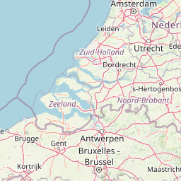
Map view of Arkemheen

Use this park location map to pinpoint Arkemheen in Netherlands, understand its exact geographic position, and read its mapped placement within the surrounding landscape more clearly.

Pigeon | © OpenStreetMap contributors
Recorded earthquake history

Explore the Arkemheen Earthquake History and Historical Seismic Records

Review documented seismic events near the Arkemheen landscape through this structured historical catalogue. MoriAtlas provides a clear, data-focused look at recorded epicenters, depths, and proximity metrics for this protected Dutch area.

Arkemheen Earthquake History

Catalogued events

1 event

Strongest magnitude

Magnitude 3.1

Most recent event

Dec 1, 1989

This history includes earthquakes recorded inside the park or within 50 km of its borders

Park atlas

Compare regional protected areas and connected lowland marsh geography

Explore Other Parks Near Arkemheen and Surrounding Protected Landscapes

Browsing other parks near Arkemheen reveals broader ecological patterns across adjacent lowland polder landscapes and wetland reserves. Comparing these connected protected areas provides deeper insight into regional conservation geography and wetland habitats.
Protected areaNetherlands
5 km away#1 closest

East

Veluwe: A Comprehensive Geographic Atlas of the Central Netherlands Protected Area

Glacial moraines, heathlands, and inland sand systems

Investigate the Veluwe, a premier protected area in the Gelderland province characterized by its historic push moraines and extensive ecological zones. The region encompasses significant sand drift complexes, dense woodlands, and vital spring-fed streams, offering a clear view of the diverse natural terrain found throughout the central Netherlands.

Area
1,000 km²
Relief
Upland
Climate
Temperate
Access
Easy access
Nature reserveFlevoland
About 7.7 km away#2 closest

Northwest

Eemmeer & Gooimeer Zuidoever: Mapped Geography and Protected Lake-Fringe Landscape

A Natura 2000 wetland reserve within the Flevoland region

The Eemmeer & Gooimeer Zuidoever nature reserve consists of two distinct yet interconnected lake basins that represent the evolving landscape of the central Netherlands. The area is defined by its shallow water fringes and marshy shorelines, which provide essential sanctuary for waterbirds. By tracing the boundary between engineered polders and older mainland provinces, this reserve provides a unique look at the ecological significance of the former Zuiderzee remnants.

Area
15.84 km²
Established
2009
Relief
Lowland
Climate
Temperate
National parkFlevoland
18 km away#3 closest

North

Nieuw Land National Park: Mapped Wetland Landscape on Flevoland's Reclaimed Land

Protected area geography and ecological discovery in the Netherlands

Nieuw Land National Park offers a distinctive protected landscape forged on land recently reclaimed from the sea in the Dutch province of Flevoland. This national park is characterized by its vast expanse of wetlands, artificial islands like the Marker Wadden, and critical importance for migratory bird populations. Delve into the park's geographic context and mapped features to understand its unique conservation value and role within the wider European atlas of protected areas.

Area
289 km²
Established
2018
IUCN
II
Relief
Lowland
A horizontal watercolor painting depicting a wetland landscape with grassy foreground, bare skeletal trees, and rolling green hills under a soft, pale sky.
Nature reserveFlevoland
19 km away#4 closest

North

Oostvaardersplassen Nature Reserve: Mapped Geography and Protected Area Context

Explore the marshland and polder terrain in Flevoland, Netherlands

Oostvaardersplassen represents a landmark in modern Dutch conservation, covering a 5,600-hectare mosaic of mudflats, reed beds, and willow thickets. This nature reserve, located between Almere and Lelystad, demonstrates the evolution of a young reclaimed landscape. It provides an essential habitat for marsh birds and large herbivores within the Nationaal Park Nieuw Land region, offering a distinct study in polder-based ecological management and wetland geography.

Area
56 km²
Established
1974
Relief
Lowland
Climate
Temperate
Nature reserveFlevoland
21 km away#5 closest

Northwest

Markermeer & IJmeer Nature Reserve: Mapping Dutch Freshwater and Polder Landscapes

A vast protected lake system shaped by historic water engineering

Spanning the distance between Flevoland and North Holland, Markermeer & IJmeer represents a significant freshwater protected area. The landscape features large lake basins framed by dike systems and recent island developments, offering a prime example of Dutch wetland geography and managed water ecosystems.

Area
79.553 km²
Established
2009
Relief
Lowland
Climate
Temperate
Nature reserveFlevoland
21 km away#6 closest

Northwest

Lepelaarplassen Nature Reserve: Protected Polder Wetlands and Marshland Geography

Ecologically significant wetland habitats in Flevoland

Lepelaarplassen is a protected wetland reserve situated on the edge of the young Flevoland polder. Featuring a blend of excavated lakes, willow marshes, and expansive reed fringes, the area provides essential habitat for colonial breeding birds and migratory species. This detailed look covers the landscape structure and regional geography of one of the most vital wetland zones along the Oostvaardersdijk.

Area
5 km²
Established
1971
Relief
Lowland
Access
Moderate access
Watercolor landscape showing green hills, forests, and a small stream with grassy patches
National parkUtrecht Province
About 23 km away#7 closest

South

Utrechtse Heuvelrug National Park: Mapped Protected Landscape and Geographic Atlas

Discover Utrecht Province's glacial ridge and diverse natural terrain.

Utrechtse Heuvelrug National Park is a significant protected natural area located in Utrecht Province, renowned for its unique glacial ridge topography. This entry provides detailed information about its mapped boundaries, diverse landscapes including heathlands and forests, and its importance as an ecological corridor within the Netherlands. Explore the park's distinct geography and its role in regional conservation through our structured atlas view.

Area
100 km²
Established
2003
IUCN
II
Visitors
1M annual
Watercolor painting of rolling hills, green trees, and a winding path
National parkGelderland
24 km away#8 closest

Southeast

De Hoge Veluwe National Park: Mapped Protected Landscape & Geographic Atlas Context

Explore Gelderland's unique heathland, sand dune, and woodland terrain.

De Hoge Veluwe National Park represents a distinctive protected area within the Gelderland region of the Netherlands. Its landscape is characterized by a unique mosaic of heathlands, sand dunes, and woodlands, shaped by ice age processes and historical land use. This page offers an atlas-focused exploration of its geographic setting, mapped boundaries, and the specific terrain that defines this significant natural and cultural heritage site.

Area
55 km²
Established
1935
IUCN
II
Visitors
629.4K annual

Common questions about visiting, size, designation, and location context for Arkemheen

Arkemheen FAQs for park facts, access, geography, and protected area context

Find quick answers about Arkemheen, including protected-area facts, park geography, trail and visitor context, and how the park fits into its surrounding country and regional landscape.
MoriAtlas Explorer

Continue Your Protected Areas Search Across the Global Atlas

Deepen your exploration by continuing the structured search for national parks and protected areas worldwide. Utilize the comprehensive filtering capabilities to compare different conservation landscapes and refine your understanding of global park geography. Discover more about the distribution and characteristics of protected natural areas.

Global natural geography