Islands
North Plover Key
0 m

Technical overview of recorded area, coastal island features, and tropical wetland terrain.
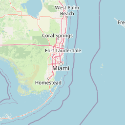
Examine the detailed geographic footprint of Everglades National Park located in Florida. This profile details the park boundary span across its 6,106 square kilometer area, including elevation ranges from sea level to 6 meters and various marine and forest habitat classifications.
Related tags
Tropical wetland wilderness protecting the unique River of Grass ecosystem
Everglades National Park is a vast protected area in southern Florida that preserves the remaining portion of the original Everglades, a network of wetlands and forests fed by the slow-moving flow of water from Lake Okeechobee into Florida Bay. The park covers nearly 1.5 million acres across Miami-Dade, Monroe, and Collier counties at the southern tip of the Florida peninsula. Established in 1947, it was the first national park created specifically to protect a fragile ecosystem rather than geological features, representing a revolutionary approach to conservation in America. The Everglades stands as the largest tropical wilderness in the United States and the largest wilderness of any kind east of the Mississippi River, encompassing one of the most distinctive and ecologically significant wetland systems on the planet.
Regional placement, coastal geography, and marine characteristics
Mapping the spatial span and calculated area of over 6,100 square kilometers
Recorded lowland relief and spatial natural features within the park
Islands
0 m
Islands
0 m
Islands
0 m
Islands
0 m
Islands
0 m
Islands
0 m
Wetland, tropical forest, and dominant water classifications across lowland terrain
Wetland · Forest · Rivers · Coast · Beach · Islands · Reefs · Woodland · Karst
Wetland · Tropical forest · Coastal habitat · Marine habitat · Peatland · Riverine habitat · Karst habitat
Compare Diverse Protected Landscapes Across Southern Florida and the Broader Southeastern United States
Southwest

Submerged reef structures and archipelago geography
Focusing on the marine geography of the Florida Keys, this detailed record outlines the sanctuary's boundaries, ranging from Atlantic coral reefs to Gulf of Mexico seagrass flats. Understand the physical scale of this protected system, its role in coastal conservation, and the unique underwater terrain that defines the southern tip of the United States.
East
Explore its protected status and geographic setting in Miami-Dade County.
Biscayne National Park represents a significant protected area managed as a U.S. National Park, safeguarding extensive coastal and marine environments. This page offers detailed insight into the park's geographic placement within Miami-Dade County, Florida, focusing on its mapped boundaries and the unique landscape it encompasses. Understand its ecological importance and its distinct contribution to the atlas of protected lands.
Northwest
Subtropical mangrove landscapes within the Florida Gulf Coast region.
This marine protected area encompasses a vast sweep of sheltered coastal waters and tidal forests at the northern edge of the Ten Thousand Islands. The reserve stands as a prime example of an undisturbed subtropical estuary, characterized by continuous mangrove shorelines and intricate hydrologic networks that provide critical habitat for numerous estuarine dependent species.
West
Explore the protected landscape and regional geography.
Uncover the protected landscape of Dry Tortugas National Park, a significant U.S. National Park located in Monroe County. This atlas entry details its mapped boundaries and unique geographic features, providing essential context for understanding its place in regional geography. Discover the distinct natural terrain and protected area identity that define Dry Tortugas National Park, supporting deeper geographic exploration.
Northeast

Discover protected area boundaries on Grand Bahama.
Lucayan National Park stands as a distinct national park entity within the geography of Grand Bahama. This page provides a focused atlas-style exploration of the park's protected landscape, detailing its mapped area and contributing to a structured understanding of its regional context. Delve into the geographic specifics that define Lucayan National Park as a key element of the Bahamas' protected lands, suitable for detailed map-based discovery and analysis.
East
Explore mapped boundaries and regional terrain context.
Delve into the specifics of Blue Holes National Park, a designated national park offering rich opportunities for geographic discovery. This entry provides structured information focused on its protected landscape identity, mapped outlines, and its contribution to the regional geography of Andros, Bahamas. Understand the park's unique setting through detailed map context and atlas-driven insights.
East
Mapping Bahamian protected marine geography and its national park boundaries.
Delve into the atlas-view of North and South Marine Parks, a key national park in the Bahamas. This page details the park's specific geographic features and its protected landscape identity within the island nation. Understand its placement and significance as a protected marine area contributing to the regional geography.
East
Mapped marine and mangrove ecosystems, plus pine forest terrain
Delve into the geographical identity of West Side National Park, a protected national park in the Bahamas renowned for its vast scale and diverse ecosystems. This landscape features significant Caribbean pine forests transitioning into extensive, intact mangrove systems along its coastlines, integrating directly with vital marine habitats. As one of the largest protected areas in the Caribbean, its ecological representation from land to sea offers a unique atlas perspective on Bahamian natural heritage and conservation.
Deepen your understanding of Everglades National Park by investigating its specific landscape character and geographic placement within Florida. This atlas view supports structured discovery of its protected-area boundaries and natural terrain, offering a factual foundation for understanding its role in the region's geography. Continue to map its context and explore the elements that define this significant national park.