
Mori Atlas logo
Nature reserveGamkaberg Nature Reserve

Mapping the convergence of four distinct Cape biomes across rugged mountain ranges and plateaus.

Gamkaberg Nature Reserve: Exploring the Mountain Geography and Protected Landscape of the Little Karoo

Located in the heart of South Africa's Little Karoo, Gamkaberg Nature Reserve protects a complex mountain range marked by steep gorges and expansive plateaus. This vital conservation landscape serves as a unique transition zone where four distinct Cape biomes converge, supporting significant biodiversity and historical rock art sites. The terrain offers a rugged look into regional geological history and the recovery of the rare Cape mountain zebra.

Little KarooWestern CapeSouth AfricaCape mountain zebraFynbosSucculent Karoo
A flat-style digital illustration depicting a desert canyon with tall rock formations, a waterfall feeding into a winding river, saguaro cacti in the foreground, and a warm sunset sky.

Gamkaberg Nature Reserve

Nature reserve

Park overview

Structured park overview, official facts, and landscape profile for Gamkaberg Nature Reserve

Gamkaberg Nature Reserve park facts, protected area profile, and essential visitor context

Review the core facts for Gamkaberg Nature Reserve, including designation, size, terrain, visitor scale, habitats, and operating context in one park-focused overview.

About Gamkaberg Nature Reserve

Gamkaberg Nature Reserve lies in the interior of the Western Cape, in South Africa's semi-arid Little Karoo between Oudtshoorn, Calitzdorp, and Vanwyksdorp. The protected area takes its name from the central Gamkaberg mountain, a name that fuses a Khoi-khoi word for lion with the Afrikaans word for mountain, evoking the region's deep indigenous and colonial cultural roots.

Founded in 1974 and now a declared World Heritage Site, the reserve was created with a very specific conservation brief: to safeguard one of the last remaining herds of Cape mountain zebra in the Little Karoo and to reintroduce game species that had disappeared from the landscape. From those beginnings, Gamkaberg has expanded into a broader conservation area that includes neighboring ranges such as Rooiberg Nature Reserve and Groenefontein Nature Reserve, all managed jointly under CapeNature. The core reserve covers about 10,430 hectares, while the wider conservation area spans roughly 80,000 hectares.

The landscape is built around mountain peaks, plateaus, and steep gorges, with the Gamka River flowing southward past the reserve on a long course from the arid Great Karoo toward the coast. Within this varied topography, four Cape biomes (Fynbos, Succulent Karoo, Subtropical Thicket, and Evergreen Forest) overlap, producing exceptional plant diversity within a relatively compact protected footprint. Fossils and Stone Age rock art embedded in the terrain add an archaeological layer that complements the reserve's ecological mission.

Today the reserve combines conservation, cultural heritage, and low-impact tourism, with hiking trails, 4x4 routes, an information center, eco-lodges, a campsite, and remote mountain stone shelters that recall the pastoral history of the Little Karoo. Gamkaberg's enduring identity is tied to its role as a refuge for Cape mountain zebra and as a meeting point of biomes in one of South Africa's most scenically and biologically distinctive semi-arid regions.

Quick facts and research context for Gamkaberg Nature Reserve

Gamkaberg Nature Reserve is located in the Little Karoo of the Western Cape, South Africa, and is managed by the conservation authority CapeNature. The reserve was established in 1974, originally to safeguard one of the region's last surviving Cape mountain zebra herds, which had dwindled to only five animals by 1976. It has since been declared a World Heritage Site, reflecting both its ecological and broader conservation significance.

The protected area comprises a core reserve of roughly 10,430 hectares, set within a larger Gamkaberg Conservation Area that extends across approximately 80,000 hectares. The terrain includes peaks, plateaus, gorges, fossils, and Stone Age rock art sites, and the reserve sits where four Cape biomes converge: Fynbos, Succulent Karoo, Subtropical Thicket, and Evergreen Forest.

Protection and recognition

Documented terrestrial protection scope and international recognition context

Gamkaberg Nature Reserve Protection Status and Recognition Data

Gamkaberg Nature Reserve maintains a documented terrestrial protection scope within the regional conservation network. Official records compile standard administrative details and baseline designation metrics for verified environmental research.

Protection details

Protection scope
Terrestrial
Transboundary protection
No
Park context

Deeper park guide and search-rich context for Gamkaberg Nature Reserve

Gamkaberg Nature Reserve history, landscape, wildlife, and travel context

Explore Gamkaberg Nature Reserve through its history, landscape character, ecosystems, wildlife, conservation priorities, cultural context, and seasonal travel timing in a structured park guide built for atlas discovery and search intent.

Why Gamkaberg Nature Reserve stands out

Gamkaberg Nature Reserve is best known for its role in the recovery of the Cape mountain zebra, a subspecies once on the brink of extinction in the Little Karoo. The reserve was established specifically around one of the last surviving herds and has become a key site for their conservation and the reintroduction of historical game species to the region. Equally distinctive is the reserve's ecological convergence, where four Cape biomes (Fynbos, Succulent Karoo, Subtropical Thicket, and Evergreen Forest) meet within a single mountain landscape. This unusual biome overlap, combined with rugged Little Karoo scenery, abundant reptile and bird life, and archaeological sites including Stone Age rock art, gives Gamkaberg a layered natural and cultural identity.
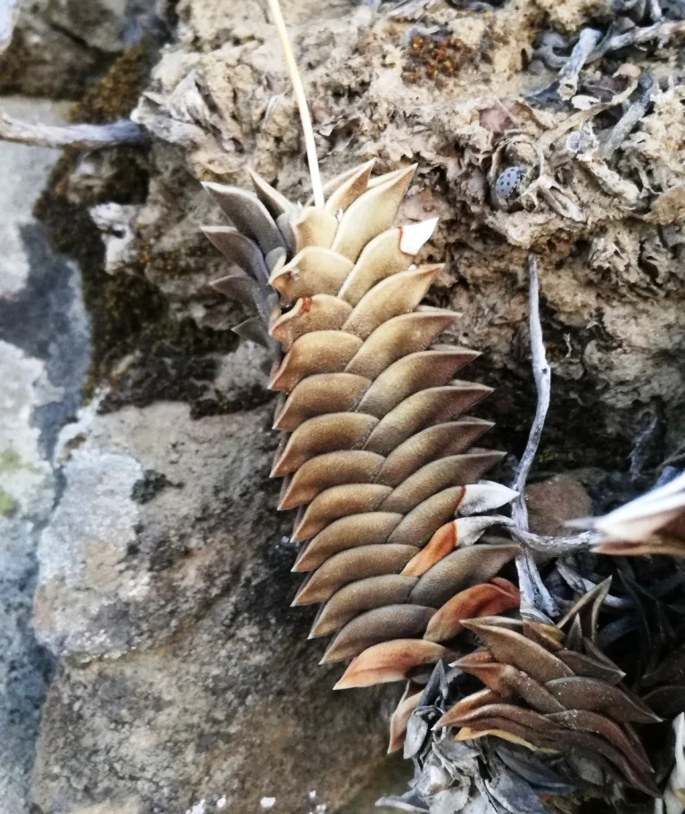
A close-up view of a Haworthia viscosa plant with triangular, stacked leaves growing out of a rocky crevice.
A Haworthia viscosa succulent growing among rocks in the Gamkaberg Nature Reserve.

Gamkaberg Nature Reserve history and protected-area timeline

Gamkaberg Nature Reserve was established in 1974 with a focused conservation mission: to protect one of the last remaining herds of Cape mountain zebra in the Little Karoo and to reintroduce game species that had been lost from the region. By 1976, the founding Cape mountain zebra herd had dwindled to only five individuals, underscoring the urgency of the reserve's creation.

Over the following decades, Gamkaberg's protected footprint expanded beyond the original core area. The reserve was later declared a World Heritage Site, signaling recognition of its broader ecological and conservation value. It now sits within the larger Gamkaberg Conservation Area, which links Gamkaberg with adjacent protected ranges such as Rooiberg Nature Reserve and Groenefontein Nature Reserve under joint CapeNature management.

Archaeological traces, including Stone Age rock art and fossils, give the landscape a much older human story that predates colonial-era names such as Gamkaberg, which itself blends a Khoi-khoi lion reference with the Afrikaans word for mountain. Remains of herders' huts, repurposed today as remote stone shelters for visitors, reflect later pastoral use of these mountains before the area was formally protected.

Gamkaberg Nature Reserve landscape and geographic character

The landscape of Gamkaberg Nature Reserve is shaped by a discrete mountain range within the Little Karoo, with peaks, plateaus, and deeply cut gorges defining the interior terrain. These mountains form a distinct subrange of the broader Little Karoo, flanked by neighboring ranges that are themselves part of the same conservation complex, including Rooiberg and Groenefontein.

The Gamka River traces a long arc through the region, beginning far to the north in the arid Great Karoo and flowing southward toward the ocean. Within the reserve, the interplay of elevation, gorges, and river valleys creates sheltered microclimates that contrast with the open, drier lowlands typical of the surrounding Karoo.

Visible across the mountains are scattered fossils and Stone Age rock art panels, embedded directly in the rocky terrain. Together with the pastoral-era stone shelters (former herders' huts now restored for visitor use), these features give the landscape a strong sense of layered geological and human history alongside its scenic mountain character.
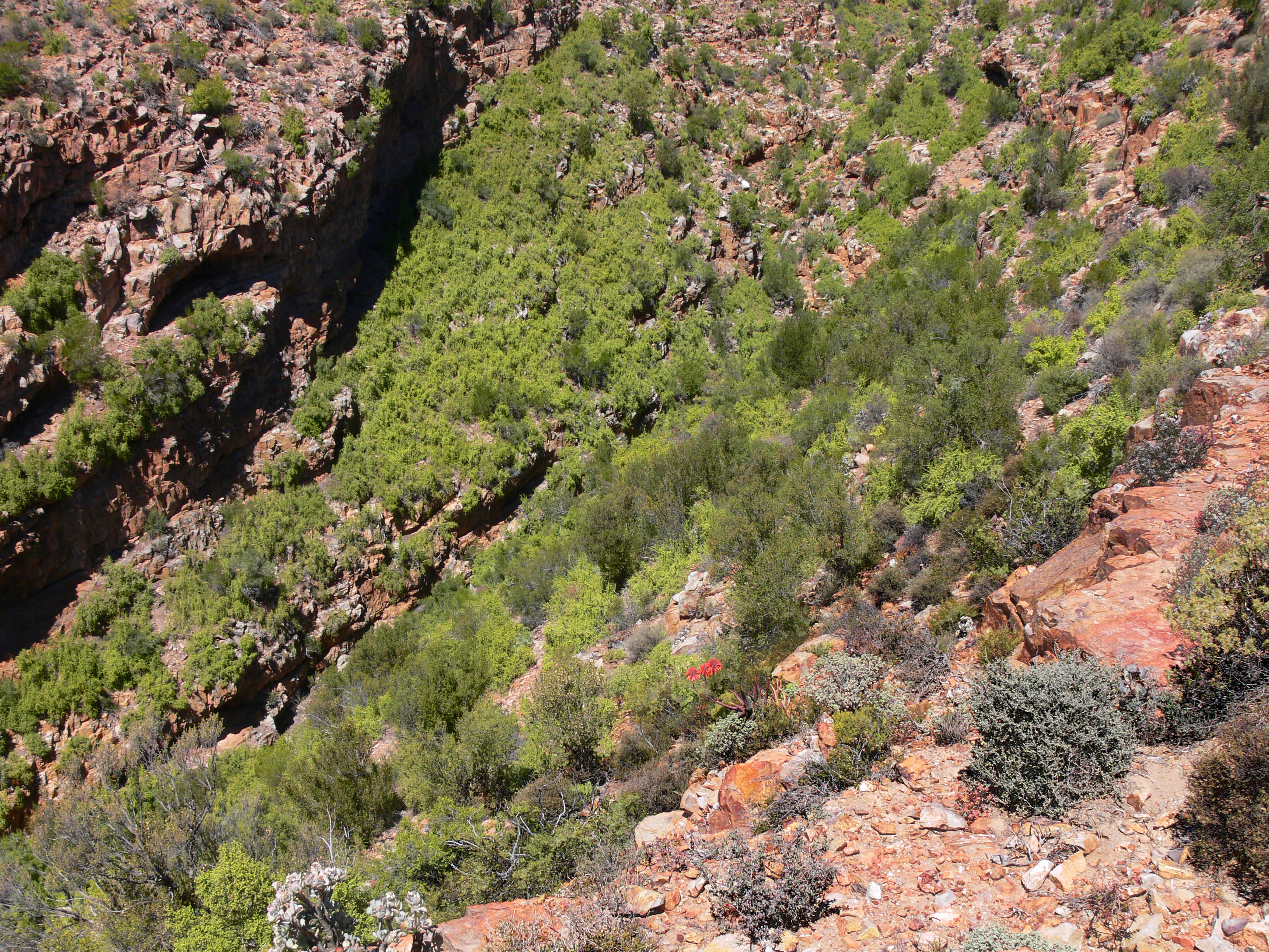
A high-angle view looking down into a rocky, steep-sided canyon filled with dense green shrubbery and trees, with exposed red rock faces along the side.
Rugged terrain and scrubby vegetation characteristic of the Gamkaberg Nature Reserve in the Little Karoo.

Gamkaberg Nature Reserve ecosystems, habitats, and plant life

Gamkaberg sits at a rare ecological crossroads where four of the Cape's distinct biomes meet within a single landscape: Fynbos, Succulent Karoo, Subtropical Thicket, and Evergreen Forest. The meeting of these vegetation systems is the reserve's defining ecological feature, supporting the unusually high plant diversity for which the greater Cape region is globally famous.

Fynbos contributes fine-leaved shrubland typical of nutrient-poor Cape soils, while Succulent Karoo brings drought-tolerant succulent species adapted to the arid Little Karoo climate. Subtropical Thicket adds denser, broader-leaved vegetation in sheltered valleys and lower slopes, and patches of Evergreen Forest occupy the most sheltered, moister microhabitats within the mountains.

This biome overlap extends beyond plants, supporting an unusually wide range of reptile and bird species alongside the reserve's better-known large mammals. The combination of arid Karoo exposures, rocky gorges, and more mesic thicket and forest patches produces a striking diversity of habitat types within a relatively compact protected area.
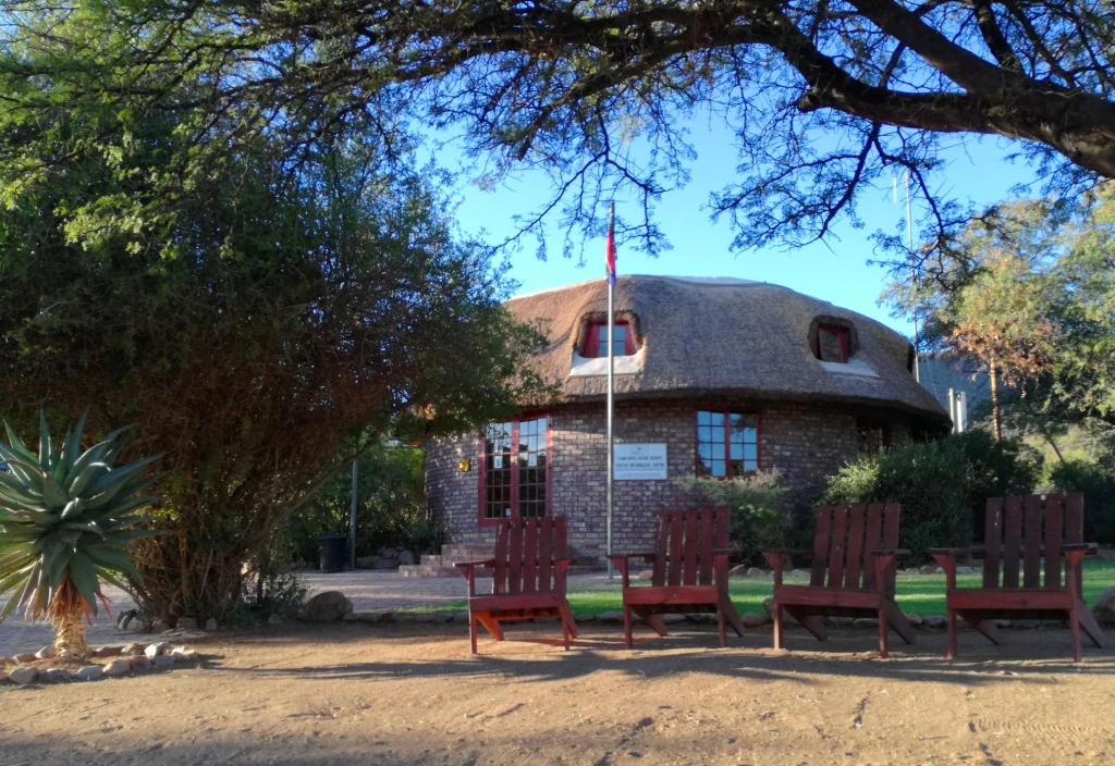
A round stone visitor center building with a thatched roof, fronted by a line of four wooden chairs under the shade of trees.
The visitors centre at Gamkaberg Nature Reserve, featuring traditional thatched roofing and outdoor seating.

Gamkaberg Nature Reserve wildlife and species highlights

The Cape mountain zebra is the species most closely associated with Gamkaberg and remains central to the reserve's conservation identity. The reserve was founded to protect one of the last herds in the Little Karoo, and this subspecies, once reduced to near-extinction, continues to be a flagship species for the property.

Alongside the zebra, Gamkaberg supports a broad community of medium and large mammals adapted to the Little Karoo, including hartebeest, Cape grysbok, and a wide range of other antelope species. Predators and scavengers such as leopard, caracal, aardwolf, and black-backed jackal round out the mammal community, reflecting the reintroduced-game vision behind the reserve's creation.

The reserve is also noted for an unusually rich reptile fauna and a wide variety of bird species, both linked to its position at the meeting point of multiple vegetation biomes. Together, these mammal, reptile, and bird communities make Gamkaberg a significant conservation area for species ranging from charismatic megafauna to smaller, often-overlooked elements of Karoo biodiversity.
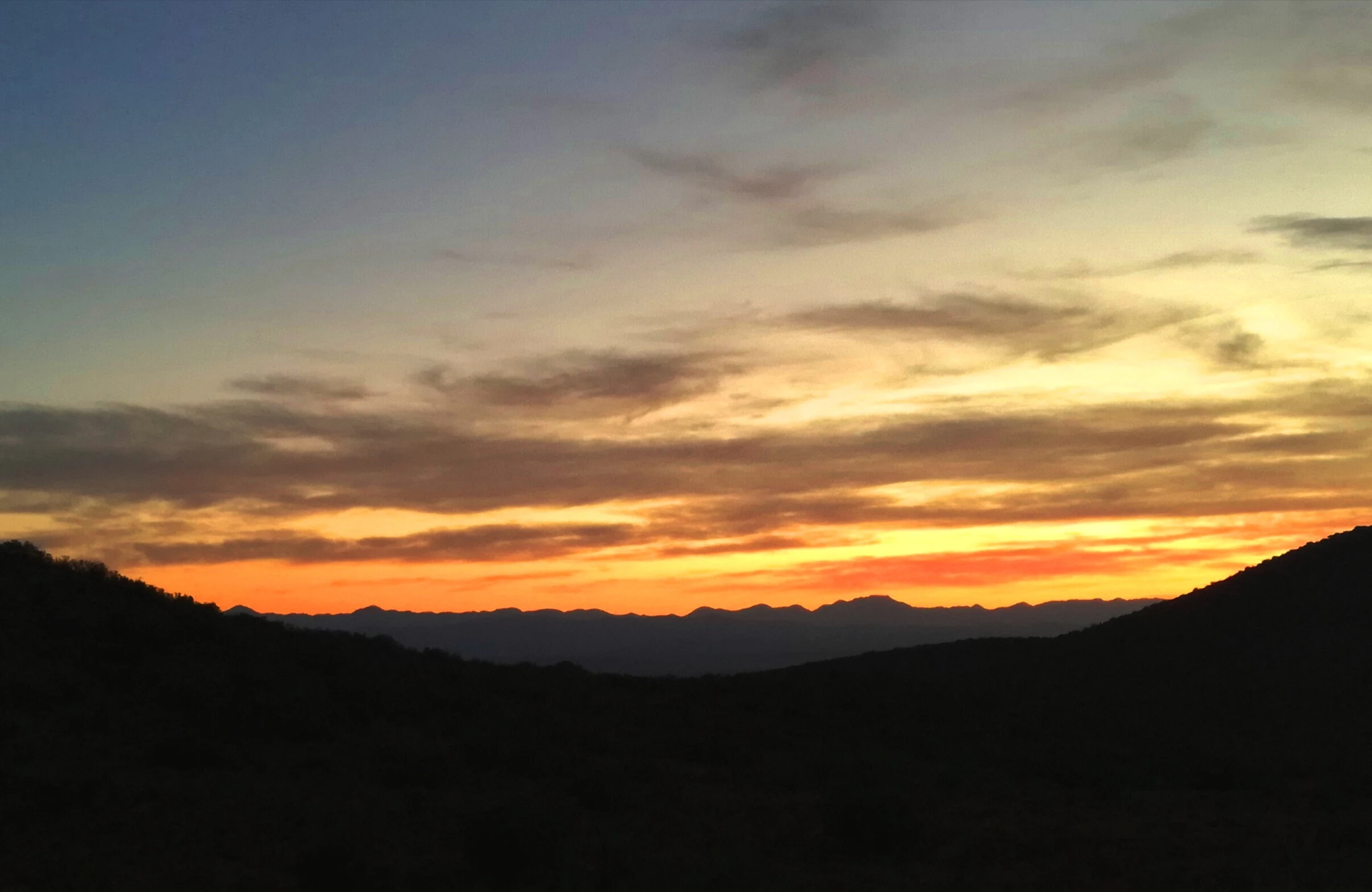
A vibrant sunrise with orange and yellow hues illuminating the sky above the dark silhouette of rolling mountain ridges.
Sunrise over the mountainous landscape of Gamkaberg Nature Reserve.

Gamkaberg Nature Reserve conservation status and protection priorities

Gamkaberg Nature Reserve was established as a direct conservation intervention: a protected area created around a tiny, isolated herd of Cape mountain zebra and designed to re-establish the broader game community of the Little Karoo. Its conservation significance is therefore rooted not only in habitat protection but also in active species recovery and translocation history.

The reserve's status as a World Heritage Site, together with CapeNature's management of a much larger linked conservation landscape of roughly 80,000 hectares, reflects recognition of its ecological value at multiple scales. The inclusion of neighboring ranges such as Rooiberg and Groenefontein within the same management framework creates connectivity across a substantial portion of the Little Karoo, supporting long-term viability of populations that require extensive range.

The reserve's location at the convergence of four Cape biomes (Fynbos, Succulent Karoo, Subtropical Thicket, and Evergreen Forest) further strengthens its conservation importance, preserving representative samples of multiple vegetation types within a single protected unit. The deliberate, low-impact design of its tourism infrastructure, from rustic eco-lodges to remote stone shelters, is aligned with this conservation mission.

Gamkaberg Nature Reserve cultural meaning and human context

The name Gamkaberg itself reflects the layered cultural history of the region, combining an indigenous Khoi-khoi word for lion with the Afrikaans suffix "berg" (mountain). This linguistic blend mirrors the broader South African heritage of indigenous and European-European colonial languages coexisting in place names across the Karoo.

Within the reserve, Stone Age rock art and fossil sites provide evidence of very long human presence in these mountains, long before formal protection or pastoral land use. The presence of old herders' huts, now restored as remote stone shelters for visitors, points to a more recent pastoral era in which the Little Karoo mountains were actively used by livestock herders.

The reserve's accommodation philosophy, emphasizing rusticity and minimum environmental impact, reflects a contemporary cultural ethic that values the landscape's natural and historical character over high-volume tourism development. This ethos links present-day visitors to both the indigenous and pastoral heritage embedded in the terrain.

Top sights and standout views in Gamkaberg Nature Reserve

The standout feature of Gamkaberg Nature Reserve is its role in saving the Cape mountain zebra in the Little Karoo, a conservation story that began with only five surviving animals and continues to define the reserve's identity today.

Equally compelling for visitors is the unusual overlap of four Cape biomes within a single mountain landscape, supporting exceptional plant diversity, abundant reptile life, varied birdlife, and a full community of reintroduced antelope and predators. Stone Age rock art, fossils, and renovated herder shelters add a tangible archaeological and pastoral dimension, while hiking, 4x4 routes, eco-lodges, and a campsite provide low-impact ways to experience the reserve's rugged scenery.

Best time to visit Gamkaberg Nature Reserve

The Little Karoo experiences a semi-arid climate with hot, dry summers and cooler, wetter winters, and seasonality matters for how Gamkaberg is experienced. Spring, roughly from August to October, is often especially rewarding because winter rains typically green the landscape and wildflower displays intensify, while cooler temperatures make hiking and 4x4 routes more comfortable.

Autumn and winter bring cooler conditions and the possibility of mountain rain and mist in the gorges, which can make trails more challenging but also highlights the reserve's succulent Karoo and thicket vegetation. Summer heat can be intense, particularly in exposed lowland and plateau areas, and the mountains' sheltered valleys may concentrate warmth.

Seasonal contrasts also affect wildlife viewing, with cooler months often bringing more active animal movement in cooler parts of the day, while spring supports peak floral diversity across the Fynbos and Succulent Karoo components of the reserve.
Monthly climate preview

Long-term temperature ranges and monthly precipitation averages for Western Cape conservation terrain

Gamkaberg Nature Reserve Climate Normals and Annual Weather Patterns

Representative coordinate records show measured monthly temperature variations and precipitation averages spanning a thirty-year climatology period. Examining the complete twelve-month dataset provides deeper insight into long-term environmental rhythms across the protected area.
Annual mean16 °C
10 °C22 °C
Jan22°
Feb22°
Mar20°
Apr17°
May14°
Jun10°
Jul10°
Aug11°
Sep14°
Oct17°
Nov19°
Dec21°
Warmest month
February

22.4 °C

Coolest month
July

10.1 °C

Wettest month
November

1.6 mm/day

Driest month
September

0.9 mm/day

Park location guide

Geography guide, regional context, and park location map for Gamkaberg Nature Reserve

Gamkaberg Nature Reserve park geography, regions, and map view in South Africa

Understand where Gamkaberg Nature Reserve sits in South Africa through a broader geographic reading of the surrounding landscape, nearby location context, and its mapped position within the national park landscape.

How Gamkaberg Nature Reserve fits into South Africa

South Africa is the southernmost country in Africa, spanning 1.22 million km² with a population of over 63 million. The country operates with three capital cities, Pretoria (executive), Cape Town (legislative), and Bloemfontein (judicial), and is renowned for its biodiversity, national parks, and multicultural society.

Wider geography shaping Gamkaberg Nature Reserve in South Africa

South Africa occupies the southernmost region of Africa, with coastline along both the Atlantic Ocean to the west and the Indian Ocean to the east. The interior features elevated plateaus including the Highveld, with the Drakensberg escarpment marking the eastern highlands. The country shares borders with Namibia, Botswana, Zimbabwe, Mozambique, Eswatini, and Lesotho.

Map view of Gamkaberg Nature Reserve

Use this park location map to pinpoint Gamkaberg Nature Reserve in South Africa, understand its exact geographic position, and read its mapped placement within the surrounding landscape more clearly.

Pigeon | © OpenStreetMap contributors

Location context for Gamkaberg Nature Reserve

Western Cape

Visualizing mountain terrain, converging biomes, and protected wildlife habitats

Gamkaberg Nature Reserve Photos and Landscape Scenery

Gamkaberg Nature Reserve photos reveal rugged mountain peaks, deep river gorges, and the converging vegetation zones of the Little Karoo. Protected-area imagery offers a clear visual reference for understanding regional biomes, rocky terrain, and native wildlife habitats.

A close-up view of a Haworthia viscosa plant with triangular, stacked leaves growing out of a rocky crevice.

Four wooden chairs arranged in a row on a gravel ground under the shade of a large tree, facing an expansive view of arid scrubland and distant mountains.

A high-angle view looking down into a rocky, steep-sided canyon filled with dense green shrubbery and trees, with exposed red rock faces along the side.

A round stone visitor center building with a thatched roof, fronted by a line of four wooden chairs under the shade of trees.

A vibrant sunrise with orange and yellow hues illuminating the sky above the dark silhouette of rolling mountain ridges.

Park atlas

Compare surrounding regional conservation landscapes and neighboring mountain reserves

Explore Protected Areas and Parks Near Gamkaberg Nature Reserve in South Africa

Visitors exploring Gamkaberg Nature Reserve can continue their geographic discovery by browsing other protected areas across the Little Karoo. Comparing adjacent mountain ranges and regional conservation zones reveals broader patterns of biodiversity and terrain across the Western Cape.
Biosphere reserveWestern Cape
About 27 km away#1 closest

Southwest

Gouritz Cluster Biosphere Reserve: Geographic Overview and Protected Area Boundaries

A diverse protected landscape spanning the Western Cape coastline to high mountain ridges.

Spanning from the southern African coast into the interior mountain ranges, this biosphere reserve captures an unmatched variety of landforms including estuaries, rocky headlands, and arid Karoo basins. It serves as a vital protected system for threatened species and endemic flora, representing one of the most ecologically significant landscapes within the Cape Floristic Region.

Area
31,878.9 km²
Established
2015
Relief
Mixed relief
Climate
Mediterranean
Wildlife reserveWestern Cape
About 40 km away#2 closest

South

Gondwana Game Reserve: Geographic Overview of a Southern Cape Rewilding Landscape

Protected mountain and coastal savanna terrain in the Western Cape

Gondwana Game Reserve represents a deliberate conservation effort to restore large mammal populations to the southern coast of South Africa. Situated near the Garden Route, the reserve encompasses a complex mosaic of open plains, rolling hills, and mountain vistas, providing essential habitat connectivity for diverse wildlife species within a protected and managed ecosystem.

Area
110 km²
Relief
Mountain
Climate
Mediterranean
Access
Access unknown
National parkSouth Africa
About 61 km away#3 closest

East

Garden Route National Park: South Africa's Protected Landscape and Forest Atlas

Explore indigenous forests, coastal cliffs, and lake systems.

Garden Route National Park is a key national park in South Africa, celebrated for its rich indigenous forests and dramatic coastline. As a protected landscape, it offers a unique geographic profile, blending ancient woodlands with rugged coastal terrain and interconnected lake systems. This page serves as an atlas entry, detailing the park's spatial extent and its significance as a conservation area within the broader geography of South Africa.

Area
1,210 km²
Established
2009
IUCN
II
Relief
Mixed relief
A soft watercolor illustration showing a hazy mountain range behind undulating, brush-filled plains in pastel tones.
Protected areaWestern Cape Province
About 99 km away#4 closest

West

Boosmansbos Wilderness Area: Geographic Atlas and Protected Landscape Overview

Rugged Langeberg mountain terrain and endemic floral corridors

Boosmansbos Wilderness Area stands as a major protected block in the eastern Langeberg range. This profile maps the diverse topography, ranging from rocky mountain ridges to moist valley forests. Learn about the geographic significance of this wilderness, which encompasses rare botanical species and serves as a vital transition zone between fynbos and indigenous forest habitats within the Western Cape.

Area
142 km²
Relief
Mountain
Climate
Mediterranean
Access
Moderate access
A horizontal watercolor painting showing rolling green hills and distant mountain ridgelines with clusters of trees in the foreground.
Nature reserveWestern Cape
About 105 km away#5 closest

West

Grootvadersbosch Nature Reserve: Protected Forest Landscapes and Langeberg Geography

Indigenous forest terrain in the Western Cape foothills.

Grootvadersbosch Nature Reserve offers a deep look into the largest surviving indigenous forest patch within the Langeberg range. This protected area integrates diverse valley geography with historic colonial farm infrastructure, providing a unique site for studying the natural terrain and river catchments of the South African Overberg region.

Area
2.5 km²
Relief
Mountain
Climate
Mediterranean
Access
Access unknown
A minimalist watercolor painting depicting rolling hills and gentle valleys in muted green, yellow, and soft red tones on a white background.
Nature reserveWestern Cape
About 122 km away#6 closest

West

Anysberg Nature Reserve: Geographic Overview and Protected Landscape Mapping

A diverse mountain sanctuary in the Western Cape Karoo.

Anysberg Nature Reserve offers a deep look into the semi-arid mountain geography of South Africa's Western Cape. Spanning a rugged stretch of the Cape Fold Belt, the reserve highlights transitions between fynbos mountain slopes and succulent valley floors. This protected area serves as an essential case study for understanding how topography, ancient river courses, and varied soil conditions influence the distribution of endemic plant life and animal habitats across the Little Karoo region.

Area
796.29 km²
Established
1984
Relief
Mountain
Climate
Mediterranean
National parkSouth Africa
About 128 km away#7 closest

East

Knysna National Lake Area National Park: A Protected Landscape in South Africa

Explore its mapped boundaries and regional natural geography.

Knysna National Lake Area National Park is a key protected area in South Africa, offering a focused lens for understanding national park geography and protected landscapes. This entry provides an atlas-centric perspective on its landscape context, mapped terrain, and its significance as a distinct natural area within the broader South African geography. Explore the structured details of this park's protected boundaries and its contribution to the country's conservation map.

Access
Easy access
Scope
Mixed
Water
Water-dominated
National parkWestern Cape
About 128 km away#8 closest

East

Wilderness National Park: National Park in Western Cape Province, South Africa

Explore mapped protected areas and regional geography.

Wilderness National Park stands as a significant protected area within the Western Cape province of South Africa. This page provides a detailed view of its role as a national park, emphasizing its geographic placement and mapped boundaries. Understand the park's contribution to the region's natural landscape and its significance within the broader atlas of protected lands.

Area
1,210 km²
Established
2009
Relief
Lowland
Access
Easy access

Common questions about visiting, size, designation, and location context for Gamkaberg Nature Reserve

Gamkaberg Nature Reserve FAQs for park facts, access, geography, and protected area context

Find quick answers about Gamkaberg Nature Reserve, including protected-area facts, park geography, trail and visitor context, and how the park fits into its surrounding country and regional landscape.
MoriAtlas Explorer

Continue Your Protected Areas Search Across the Global Atlas

Deepen your exploration by continuing the structured search for national parks and protected areas worldwide. Utilize the comprehensive filtering capabilities to compare different conservation landscapes and refine your understanding of global park geography. Discover more about the distribution and characteristics of protected natural areas.

Global natural geography