
Mori Atlas logo
National parkGoz Beïda National Park

Discover the mapped boundaries and regional geographic context of this protected national park.

Goz Beïda National Park: National Park Protected Landscape Atlas and Geographic Explorer

Goz Beïda National Park represents a significant protected area within the Sila Province of Chad. This page offers an atlas-driven exploration of its mapped boundaries and geographic identity. Delve into the landscape context that defines this national park, providing a foundation for understanding its place within the broader region's protected lands.

national parkprotected areaeastern ChadSila Provincesavanna ecosystemIUCN Category II

Goz Beïda National Park

National park

Park overview

Structured park overview, official facts, and landscape profile for Goz Beïda National Park

Goz Beïda National Park park facts, protected area profile, and essential visitor context
Review the core facts for Goz Beïda National Park, including designation, size, terrain, visitor scale, habitats, and operating context in one park-focused overview.

About Goz Beïda National Park

Goz Beïda National Park represents a significant conservation initiative in eastern Chad, a region characterized by vast savanna landscapes and semi-arid ecological conditions. The park's establishment near the town of Goz Beïda in Sila Province demonstrates Chad's effort to protect its natural ecosystems despite facing considerable development pressures and security challenges. At approximately 3,000 square kilometers, the protected area encompasses a meaningful extent of eastern Chad's terrain, providing space for ecological processes to continue and for wildlife populations to maintain viable habitats. The park exists within a broader context of conservation challenges in Chad, where protected areas must balance ecological preservation with the needs of local communities and the realities of regional instability. Goz Beïda's designation as a national park signals institutional recognition of its ecological value and provides a framework for ongoing protection and management.

Quick facts and research context for Goz Beïda National Park

Goz Beïda National Park is located in eastern Chad, specifically in Sila Province near the town of Goz Beïda. The protected area covers roughly 3,000 square kilometers of terrain. As an IUCN Category II protected area, it is managed as a national park with standard conservation protection status. The park lies in a region that has experienced internal conflicts, yet it has maintained its role as a habitat for endangered plant and animal species. Chad, a landlocked Central African nation, maintains this protected area as part of its network of national parks spanning diverse ecological zones.

Park context

Deeper park guide and search-rich context for Goz Beïda National Park

Goz Beïda National Park history, landscape, wildlife, and travel context
Explore Goz Beïda National Park through its history, landscape character, ecosystems, wildlife, conservation priorities, cultural context, and seasonal travel timing in a structured park guide built for atlas discovery and search intent.

Goz Beïda National Park history and protected-area timeline

Goz Beïda National Park was established as part of Chad's national park system, representing the country's efforts to create a network of protected areas spanning its diverse ecological regions. While the specific year of establishment is not detailed in available sources, the park's creation reflects a broader movement in Chad to designate meaningful territorial protections for natural areas. The park's location in eastern Chad places it within a region that has experienced internal conflicts and security concerns, making its continued existence as a protected area a notable achievement. Despite these challenges, the park has maintained its conservation status and continued to function as a refuge for endangered species. The establishment of Goz Beïda as a national park represents a policy commitment to biodiversity preservation in an area that might otherwise face pressures from human activity and development.

Goz Beïda National Park ecosystems, habitats, and plant life

Goz Beïda National Park occupies a portion of eastern Chad's savanna ecosystem, a landscape characterized by seasonal grasslands, scattered woodland vegetation, and the distinctive semi-arid conditions of the Sahel transition zone. The protected area lies in a region where rainfall patterns create distinct wet and dry seasons, influencing vegetation patterns and wildlife distribution throughout the year. The park's terrain supports habitats that are representative of eastern Chad's broader ecological character, featuring species adapted to surviving in environments with limited water availability and high seasonal temperature variations. While detailed ecological surveys are not readily available, the park's designation as a refuge for endangered species indicates the presence of ecologically significant habitats capable of supporting sensitive wildlife populations.

Goz Beïda National Park conservation status and protection priorities

Goz Beïda National Park serves as an important conservation asset within Chad's protected area network. The park's IUCN Category II designation establishes it as a national park with the primary mandate of protecting natural ecosystems and enabling wildlife conservation. Despite facing challenges from regional conflicts that have affected eastern Chad, the park has retained its function as a haven for endangered plant and animal species. This persistence is significant given the broader pressures facing Chad's natural environments, including habitat loss, poaching, and the impacts of climate change on semi-arid ecosystems. The park's continued existence demonstrates both the resilience of natural systems when given protected status and the commitment of conservation authorities to maintain protective measures even in difficult circumstances.

Park location guide

Geography guide, regional context, and park location map for Goz Beïda National Park

Goz Beïda National Park park geography, regions, and map view in Chad
Understand where Goz Beïda National Park sits in Chad through a broader geographic reading of the surrounding landscape, nearby location context, and its mapped position within the national park landscape.

How Goz Beïda National Park fits into Chad

Chad is a landlocked Central African nation spanning approximately 1.28 million km². It borders six countries and contains three distinct regions: the Sahara desert in the north, the Sahel in the center, and the Sudanian Savanna in the south. Lake Chad, after which the country is named, is the second-largest wetland in Africa. Chad gained independence from France in 1960 and has a population of about 19 million.

Wider geography shaping Goz Beïda National Park in Chad

Chad is located in Central Africa and is landlocked, bordered by six countries. The terrain varies from the Sahara desert in the north through the Sahel arid zone in the center to the more fertile Sudanian Savanna in the south. Lake Chad, a major shallow wetland, lies in the southwestern part of the country near the Nigeria border.

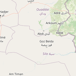
Map view of Goz Beïda National Park

Use this park location map to pinpoint Goz Beïda National Park in Chad, understand its exact geographic position, and read its mapped placement within the surrounding landscape more clearly.

Pigeon | © OpenStreetMap contributors

Location context for Goz Beïda National Park

Sila Province
Park atlas

Explore surrounding protected landscapes and compare regional park geography across eastern Chad and beyond.

Discover Other National Parks and Protected Areas Near Goz Beïda National Park
After exploring Goz Beïda National Park, browse additional national parks and protected areas to understand the broader savanna ecosystems and conservation efforts across eastern Chad. This geographic overview allows for direct comparison of park characteristics, tracing regional landscape patterns and the distribution of protected territories.
National parkGuéra Region

Zakouma National Park: Chad's Premier National Park and Protected Landscape

Explore the mapped savanna, acacia forests, and wildlife geography.

Zakouma National Park is Chad's oldest and most ecologically vital protected area, spanning 3,000 square kilometers of Sudano-Sahelian landscape. Situated within the Guéra Region, it is globally recognized for its exceptional Kordofan giraffe population, significant elephant recovery, and ongoing conservation successes, offering a unique view into African wildlife and protected area management.

Area
3,000 km²
Established
1963
IUCN
II
Relief
Lowland
National parkChad

Aouk National Park National Park: Mapped Protected Landscape and Regional Geography

Explore Chad's Aouk National Park boundaries and terrain.

Investigate Aouk National Park, a significant national park in Chad, through its detailed mapping and protected landscape attributes. This entry provides insight into the park's geographic placement within Central Africa, emphasizing its role as a conservation area. Users can explore the mapped boundaries and regional geographic context, facilitating a structured understanding of this protected territory for atlas-based research and discovery.

Area
7,400 km²
IUCN
II
Access
Moderate access
Scope
Terrestrial
National parkSudan

Radom National Park: A National Park in Sudan Offering Protected Landscape and Geographic Context

Explore mapped boundaries and regional terrain within Sudan.

Radom National Park is an important protected area designated as a national park in Sudan. This entry focuses on its specific geographic features and landscape characteristics, providing users with a detailed view of its mapped boundaries and regional context. Understanding Radom National Park's place within the atlas of African protected lands helps illuminate its natural terrain and conservation significance.

Area
12,509.7 km²
Established
1980
IUCN
II
Relief
Lowland
National parkMoyen-Chari Region

Manda National Park: National Park Protected Landscape and Geographic Identity in Moyen-Chari

Discover mapped terrain and regional context for this Chad national park.

Manda National Park, a protected natural area within Chad's Moyen-Chari Region, offers valuable insights into regional geography and mapped protected landscapes. This detail page provides focused information on the park's identity as a national park, emphasizing its geographic setting and the importance of its mapped boundaries for structured atlas exploration. Understand how this protected area contributes to the diverse natural terrain of the Moyen-Chari Region.

Area
1,140 km²
Established
1969
IUCN
II
Climate
Tropical
National parkFar North Region

Waza National Park: A Designated Protected Landscape in the Far North Region

Mapped Boundaries and Regional Geographic Context

Waza National Park stands as a vital protected natural landscape in Cameroon's Far North Region. This entry provides a deep dive into its mapped protected-area boundaries and its significance within the broader regional geography. Explore the specific landscape identity of this national park through an atlas-focused lens, understanding its terrain and context without travel logistics or visitor advice.

Area
1,700 km²
Established
1934
IUCN
II
Relief
Lowland
National parkNigeria

Chad Basin National Park: Exploring Nigeria's Protected Natural Landscape

Mapped protected area and regional geography context.

Chad Basin National Park is a key protected landscape within Nigeria, designated as a national park. This page serves as a gateway to understanding its specific geographic identity, mapped boundaries, and its role within the country's natural terrain. Users can explore detailed information, focusing on the park's atlas-relevant features and its contribution to Nigeria's protected areas, offering a distinct view of the nation's geography.

Area
2,258 km²
Established
1991
IUCN
II
Relief
Lowland
National parkCameroon

Bouba Njida National Park: A Protected Landscape within Cameroon's National Park Atlas

Discover its mapped geography and regional context.

Bouba Njida National Park represents a key component of Cameroon's protected lands, contributing essential context to any atlas of Central African geography. As a designated national park, it offers a distinct focus for understanding mapped landscape features and the distribution of protected areas within the country. This park serves as a vital point of reference for exploring the nation's natural terrain and its significance within the broader context of regional conservation efforts.

Area
2,200 km²
Established
1980
IUCN
II
Relief
Upland
Watercolor illustration of a landscape with rolling hills, a winding river, and varied terrain in soft colors
National parkBénoué Department

Bénoué National Park: Protected Landscape Atlas in Bénoué Department, Cameroon

Explore savanna woodland, riparian ecosystems, and geographic context.

Bénoué National Park is a vast protected landscape in Cameroon, defined by its Sudanian savanna woodland and significant frontage along the Bénoué River. Recognized as a UNESCO Biosphere Reserve, it offers critical insights into regional geography, habitat diversity, and the broader atlas of conservation lands in West Africa. Users can explore its varied terrain, from riverine zones to higher massifs, gaining a detailed understanding of this important protected area.

Area
1,800 km²
Established
1968
IUCN
II
Relief
Mixed relief

Common questions about visiting, size, designation, and location context for Goz Beïda National Park

Goz Beïda National Park FAQs for park facts, access, geography, and protected area context
Find quick answers about Goz Beïda National Park, including protected-area facts, park geography, trail and visitor context, and how the park fits into its surrounding country and regional landscape.
MoriAtlas Explorer

Continue Your Protected Areas Search Across the Global Atlas

Deepen your exploration by continuing the structured search for national parks and protected areas worldwide. Utilize the comprehensive filtering capabilities to compare different conservation landscapes and refine your understanding of global park geography. Discover more about the distribution and characteristics of protected natural areas.

Global natural geography
