

Mori Atlas logo
National parkGreater Kingston National Park

Mapping the geographic identity and park boundaries of this Western Australian national park.

Greater Kingston National Park: Protected Landscape in Western Australia

Greater Kingston National Park is a significant protected area situated within the diverse geography of Western Australia. As a designated national park, it offers a unique lens through which to explore the region's natural landscapes and mapped terrain. This entry serves as a gateway to understanding the park's protected status, its contribution to the regional geography, and its role within a structured atlas of Australia's natural heritage.

National ParkWestern AustraliaJarrah ForestNumbat ConservationOld-Growth ForestEndangered Species

Greater Kingston National Park

National park

Park overview

Structured park overview, official facts, and landscape profile for Greater Kingston National Park

Greater Kingston National Park park facts, protected area profile, and essential visitor context

Review the core facts for Greater Kingston National Park, including designation, size, terrain, visitor scale, habitats, and operating context in one park-focused overview.

About Greater Kingston National Park

Greater Kingston National Park represents a significant conservation achievement in Western Australia's South West, protecting a substantial area of intact old-growth forest within one of the state's most biologically diverse bioregions. The park occupies land within the Jarrah Forest bioregion, an area characterized by rolling terrain, lateritic soils and woodlands dominated by two key eucalyptus species: jarrah (Eucalyptus marginata) and wandoo (Eucalyptus wandoo). These woodlands form the structural and ecological foundation of the park, supporting a range of dependent species and representing relatively unmodified forest compared to areas that have been heavily logged or cleared for agriculture. The park's creation in 2004 reflected a growing recognition of the conservation value of Western Australia's remaining old-growth forests and the need to formalize protection for areas harboring significant biodiversity. As a Class A reserve, the park receives the highest level of statutory protection available under Western Australian law, providing durable security against future land-use changes or resource extraction. The park's location across three local government shires reflects the extent of the protected forest tract, which connects with other conservation areas and state forest to form a broader network of protected lands in the South West region.

Quick facts and research context for Greater Kingston National Park

Greater Kingston National Park covers 21,092 hectares (52,120 acres) of forested terrain in Western Australia's South West region. The park is located within the Shires of Bridgetown-Greenbushes, Boyup Brook and Manjimup, approximately 308 kilometres south of Perth. It lies within the Jarrah Forest bioregion, characterized by old-growth jarrah and wandoo woodland ecosystems. The park was formally established on 8 December 2004 as Class A reserve No. 47762 through an act of the Western Australian Parliament. It is administered by the Department of Biodiversity, Conservation and Attractions. The park serves as a crucial refuge for the numbat, one of Australia's most endangered marsupials, hosting a remnant wild population.

Protection and recognition

Documenting the terrestrial boundary, conservation framework, and national protection status

Greater Kingston National Park Protection Status and Conservation Designation

Explorers can verify the documented terrestrial protection status and established conservation scope for Greater Kingston National Park. Reviewing official registry details provides essential geographic context regarding the formal environmental oversight of the mapped landscape.

Protection details

Protection scope
Terrestrial
Transboundary protection
No
Park context

Deeper park guide and search-rich context for Greater Kingston National Park

Greater Kingston National Park history, landscape, wildlife, and travel context

Explore Greater Kingston National Park through its history, landscape character, ecosystems, wildlife, conservation priorities, cultural context, and seasonal travel timing in a structured park guide built for atlas discovery and search intent.

Why Greater Kingston National Park stands out

Greater Kingston National Park is best known as one of just two remaining locations in Australia where original numbat sub-populations survive in the wild. The numbat, a small marsupial that feeds almost exclusively on termites, was driven to the brink of extinction across most of its former range by introduced predators and habitat loss. The Upper Warren area, which includes Greater Kingston National Park along with the Tone-Perup Nature Reserve and adjacent State Forest, represents one of the last strongholds for this endangered species. The park's old-growth jarrah and wandoo woodlands provide the intact forest habitat essential for numbat survival, making the area irreplaceable for conservation efforts targeting species recovery.

Greater Kingston National Park history and protected-area timeline

Greater Kingston National Park was formally established on 8 December 2004 when the Parliament of Western Australia passed legislation creating the reserve. The park was declared as Class A reserve No. 47762, encompassing an area of 21,092 hectares (52,120 acres). This establishment was part of a significant expansion of Western Australia's national park system, with 19 new national parks declared across the state on the same day. This wave of park declarations represented the culmination of extended conservation planning and community advocacy for protecting remaining old-growth forests in the South West region. The creation of Greater Kingston built upon earlier conservation efforts in the area, recognizing that the jarrah forests of the Upper Warren region contained exceptional natural values warranting formal protection. Prior to national park status, the land had been managed as state forest, and the transition to full national park designation reflected evolving understanding of the area's ecological significance, particularly its importance for endangered species conservation.

Greater Kingston National Park landscape and geographic character

The landscape of Greater Kingston National Park is characteristic of the Jarrah Forest bioregion, featuring gently undulating terrain with elevations varying across the park's extensive area. The underlying geology consists largely of laterite-derived soils, which support the distinctive jarrah and wandoo woodland that defines the park's visual character. Jarrah trees dominate the canopy, creating a relatively open forest structure with a sparse understory of shrubs and grasses adapted to the nutrient-poor soils. Wandoo occurs in more localized stands, often in lower-lying or moister areas. The forest structure varies across the park, with some areas showing the more open character of mature woodland while other sections contain denser regrowth following past disturbance. The park's extensive area allows for subtle variations in topography, aspect and soil moisture to create a heterogeneous landscape that supports diverse ecological communities.

Greater Kingston National Park ecosystems, habitats, and plant life

Greater Kingston National Park protects an example of old-growth jarrah forest ecosystem that has become increasingly rare across the South West of Western Australia. The jarrah-wandoo woodlands represent a distinctive Australian forest type, adapted to the Mediterranean climate of the region with its hot dry summers and cool wet winters. These forests support a complex community of native plants and animals that have evolved to depend on the structural features of old-growth woodland, including hollow-bearing trees, fallen logs and diverse understory vegetation. The park's ecological significance is magnified by its role in protecting habitat for species of conservation concern, particularly the numbat. The jarrah forest provides the structural complexity necessary for numbats to find shelter and forage for their termite prey. The Upper Warren area, encompassing Greater Kingston and adjacent conservation reserves, represents one of the most intact forest landscapes remaining in the South West bioregion.

Greater Kingston National Park wildlife and species highlights

The wildlife of Greater Kingston National Park is defined to a significant degree by the presence of the numbat, an endangered marsupial that represents one of Australia's most notable conservation stories. Numbats are uniquely specialized predators, feeding almost exclusively on termites and using their long sticky tongues to extract prey from within timber and soil. Once found across much of southern Australia, numbats now survive in the wild at only two locations, with the Upper Warren population including Greater Kingston National Park representing one of these critical refuges. The park's old-growth jarrah and wandoo woodlands provide the intact forest structure that numbats require, with hollow logs and dead trees offering denning sites and the litter layer supporting termite populations. Beyond numbats, the jarrah forest supports a range of other native species including various marsupials, birds and reptiles, though the Wikipedia source focuses particularly on the numbat significance as the park's defining wildlife value.

Greater Kingston National Park conservation status and protection priorities

Greater Kingston National Park holds exceptional conservation significance as one of only two locations maintaining original numbat sub-populations in Australia. The numbat was formerly distributed across much of southern Australia but underwent catastrophic decline due to predation by introduced foxes and cats, competition from introduced rabbits, and habitat loss through land clearing. By the 1990s, the species was reduced to a handful of remnant populations, with the Upper Warren region representing one of the most significant survivors. The creation of Greater Kingston National Park formalized protection for this critical numbat habitat, working alongside the Tone-Perup Nature Reserve and adjoining State Forest to form a network of conservation lands. The park's Class A reserve status provides strong legal protection, while its inclusion within the broader jarrah forest bioregion connects it to regional conservation planning. The park demonstrates how protected area establishment can serve as a foundation for species recovery, though the numbat remains dependent on ongoing active management including predator control.

Greater Kingston National Park cultural meaning and human context

The cultural context of Greater Kingston National Park is not extensively documented in the available source material. The park lies within the traditional lands of Aboriginal people of the South West region, though specific information about indigenous connections to the area is not provided in the Wikipedia entry. The park's recent establishment in 2004 means it does not have the extended historical relationship with European settlement that characterizes some older protected areas in Western Australia. The broader South West region contains significant Aboriginal heritage values, and the jarrah forests have been important to Indigenous communities for thousands of years. The park sits within an area that has been subject to timber harvesting and pastoral use prior to protection, though the focus of available information is on the park's conservation values rather than cultural history.

Top sights and standout views in Greater Kingston National Park

Greater Kingston National Park's standout feature is its role as a refuge for Australia's endangered numbat, representing one of just two remaining wild populations of this distinctive marsupial. The park protects extensive old-growth jarrah and wandoo woodland within the Jarrah Forest bioregion, representing some of the most intact forest remaining in South West Western Australia. As a Class A reserve established in 2004, the park represents a significant conservation achievement, providing durable protection for forest ecosystems and the species they support. The park's location in the Upper Warren area links it with adjacent conservation reserves, forming an important network for biodiversity protection in a region where old-growth forest has been extensively cleared or degraded.

Best time to visit Greater Kingston National Park

The optimal time to visit Greater Kingston National Park would align with the dry summer months typical of Western Australia's Mediterranean climate. The period from late spring through early autumn (approximately October to April) generally offers more comfortable conditions for exploring the forest, with warmer temperatures and lower rainfall. However, the park's primary significance lies in its conservation values rather than as a visitor destination, and detailed information about visitor facilities, access arrangements or seasonal conditions is not provided in the available source material. The numbat is most active during warmer months, potentially offering better wildlife viewing opportunities in summer, though visitors should note that seeing these secretive animals in their forest habitat requires patience and appropriate timing.
Monthly climate preview

Long-term monthly temperature and precipitation rhythm in Western Australia

Greater Kingston National Park Climate Normals and Average Temperature Patterns

Representative coordinates record measured monthly averages from 1991 to 2020, charting shifts between high summer maxima and winter precipitation peaks across Greater Kingston National Park. Exploring the complete twelve-month climate profile reveals granular shifts in temperature ranges and rainfall distributions across the terrain.
Annual mean15 °C
10 °C22 °C
Jan21°
Feb22°
Mar20°
Apr17°
May13°
Jun11°
Jul10°
Aug10°
Sep11°
Oct13°
Nov16°
Dec19°
Warmest month
February

21.5 °C

Coolest month
July

10 °C

Wettest month
July

4.3 mm/day

Driest month
February

0.5 mm/day

Park location guide

Geography guide, regional context, and park location map for Greater Kingston National Park

Greater Kingston National Park park geography, regions, and map view in Australia

Understand where Greater Kingston National Park sits in Australia through a broader geographic reading of the surrounding landscape, nearby location context, and its mapped position within the national park landscape.

How Greater Kingston National Park fits into Australia

Australia is a constitutional monarchy and federal parliamentary democracy comprising six states and ten territories. With a population of nearly 28 million, it is one of the world's most urbanised countries, with most people concentrated on the eastern seaboard. The country has a high Human Development Index and is known for its cultural diversity, ancient Aboriginal heritage, and unique wildlife.

Wider geography shaping Greater Kingston National Park in Australia

Australia occupies the entire Australian continent, the island of Tasmania, and numerous smaller islands. It is the world's flattest and driest inhabited continent, featuring vast deserts in the interior (the Outback), tropical rainforests along the eastern coast, and a coastline bordering the Indian and Pacific Oceans.

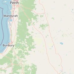
Map view of Greater Kingston National Park

Use this park location map to pinpoint Greater Kingston National Park in Australia, understand its exact geographic position, and read its mapped placement within the surrounding landscape more clearly.

Pigeon | © OpenStreetMap contributors

Location context for Greater Kingston National Park

Western Australia
Recorded earthquake history

Browse the Historical Record of Earthquakes Near Greater Kingston National Park

Explore the MoriAtlas catalogue of documented seismic activity and earthquake events associated with Greater Kingston National Park. Review historical data points to better understand the seismic landscape of this region in Western Australia through a clear and structured perspective.

Greater Kingston National Park Earthquake Records

Catalogued events

5 events

Strongest magnitude

Magnitude 5.3

Most recent event

Nov 8, 2018

This history includes earthquakes recorded inside the park or within 50 km of its borders

Park atlas

Compare the geographic spread of protected landscapes within Western Australia's Jarrah Forest bioregion.

Explore National Parks and Protected Areas Near Greater Kingston National Park

Browse national parks and protected areas situated near Greater Kingston National Park, mapping the diverse conservation landscapes across Western Australia's South West region. Compare their diverse ecosystems and protected statuses to understand the regional spread of conservation efforts across the Jarrah Forest bioregion and adjacent areas.
National parkAustralia
25 km away#1 closest

Northwest

Dalgarup National Park: Protected Forest Landscape and Regional Geographic Context in Western Australia

Mapped boundaries of protected areas within the Jarrah Forest bioregion.

Dalgarup National Park serves as a crucial protected area, safeguarding the characteristic jarrah-marri forest ecosystems of southwestern Australia. Located within the Jarrah Forest and Warren bioregions, its terrain reflects the undulating topography and Mediterranean climate prevalent in the South West land division. This national park offers a unique opportunity to explore mapped natural landscapes and understand the conservation efforts within a region historically shaped by forest ecology and development.

Area
23.77 km²
Established
2004
Scope
Terrestrial
Water
Minor water
National parkAustralia
26 km away#2 closest

South

Greater Dordagup National Park: National Park Landscape and Geographic Context in Australia

Explore mapped boundaries and protected land identity.

Greater Dordagup National Park is presented as a distinct protected landscape within the Australian national park system. This entry focuses on its geographic setting and the structured information available for atlas exploration. Users can examine the park's mapped features and understand its contribution to Australia's collection of natural reserves and protected terrains.

Area
64.08 km²
Established
2004
Climate
Temperate
Access
Easy access
National parkWestern Australia
26 km away#3 closest

Southwest

Sir James Mitchell National Park: National Park, Western Australia - Geographic Atlas View

Mapped protected area with regional landscape context.

Gain a structured understanding of Sir James Mitchell National Park as a key protected landscape within Western Australia. This atlas entry focuses on the park's geographic extent, its status as a national park, and its position within the diverse regional geography of Western Australia, offering clear insights for map-based exploration and conservation landscape analysis.

Area
2.47 km²
Established
1969
IUCN
II
Access
Access unknown
National parkWestern Australia
30 km away#4 closest

South

Shannon National Park: A Protected Landscape in Western Australia's Geography

Discover the mapped boundaries and regional park context.

Shannon National Park represents a key protected area within the vast geographic expanse of Western Australia. This entry focuses on understanding its identity as a national park, highlighting its specific landscape character and its contribution to the regional atlas. Through detailed mapping and geographic context, users can explore the protected boundaries and natural setting of Shannon National Park.

Area
525.98 km²
Established
1988
IUCN
II
Relief
Mixed relief
National parkShire of Manjimup
32 km away#5 closest

Southeast

Boyndaminup National Park: Explore Protected Area Boundaries and Geographic Setting

An Australian national park with distinct mapped landscapes.

Boyndaminup National Park is a key protected area providing rich opportunities for geographic discovery. This atlas-focused entry details its mapped boundaries and situates it within the broader landscape context of the Shire of Manjimup. Understand the park's identity as a national park and its role in Australia's conservation network, offering specific insights for map-based exploration and regional geography.

Area
54.43 km²
Established
2004
IUCN
II
Scope
Terrestrial
National parkWestern Australia
36 km away#6 closest

Southwest

Gloucester National Park: National Park in Western Australia's Geographic Landscape

Explore mapped boundaries and protected land context.

Gloucester National Park stands as a significant protected area within the vast geographic expanse of Western Australia. This entry focuses on its identity as a national park, detailing its mapped landscape features and regional context. Understanding Gloucester National Park involves appreciating its specific geographic setting and its contribution to the atlas of protected natural areas in Australia, providing foundational data for landscape exploration.

Area
8.78 km²
Established
1993
IUCN
II
Access
Moderate access
National parkWestern Australia
37 km away#7 closest

Southwest

Greater Beedelup National Park: Western Australia's National Park Landscape

Discover Protected Areas and Regional Geography

Explore Greater Beedelup National Park, a key protected landscape within Western Australia. This national park offers a focus for understanding mapped natural features and the regional distribution of conservation areas. It serves as a vital point for atlas-based discovery, providing structured insights into the park's geographic setting and its identity as a protected natural area.

Area
17.83 km²
Established
1915
IUCN
II
Relief
Upland
National parkAustralia
41 km away#8 closest

South

Jane National Park: Western Australia's Protected Old-Growth Forest Landscape

Mapped forest ecosystems in the South West bioregion.

Jane National Park represents a key protected landscape in the South West of Western Australia, recognized for its significant old-growth forest ecosystems. This Class A reserve preserves mature stands of karri and jarrah trees, offering a glimpse into the region's undisturbed natural heritage. Its landscape is characterized by dense, ancient forests dominating gentle terrain, making it an important site for understanding the conservation value of this bioregion and exploring its mapped natural context.

Area
68.63 km²
Established
2004
IUCN
II
Scope
Terrestrial

Common questions about visiting, size, designation, and location context for Greater Kingston National Park

Greater Kingston National Park FAQs for park facts, access, geography, and protected area context

Find quick answers about Greater Kingston National Park, including protected-area facts, park geography, trail and visitor context, and how the park fits into its surrounding country and regional landscape.
MoriAtlas Explorer

Continue Your Protected Areas Search Across the Global Atlas

Deepen your exploration by continuing the structured search for national parks and protected areas worldwide. Utilize the comprehensive filtering capabilities to compare different conservation landscapes and refine your understanding of global park geography. Discover more about the distribution and characteristics of protected natural areas.

Global natural geography