Mori Atlas logo
Natural monumentGrotte Marie-Jeanne

A three-level limestone labyrinth revealing complex geological formations and historical petroglyphs

Grotte Marie-Jeanne Natural Monument: Mapping the Subterranean Karst Landscapes of Haiti

Grotte Marie-Jeanne stands as a significant natural monument and the longest known cave system in Haiti. This expansive karst labyrinth spans over five kilometers of subterranean galleries across three vertical levels, carved into iron oxide and calcium carbonate rich limestone within the hills near Port-à-Piment. The site integrates geological complexity with cultural heritage, preserving ancient Taíno petroglyphs alongside a series of named chambers that trace biblical and historical narratives through the rock.

karst cavelimestone cavesubterranean labyrinthHaitian natural heritagepre-Columbian archaeologypetroglyphs

Grotte Marie-Jeanne

Natural monument

Park overview

Structured park overview, official facts, and landscape profile for Grotte Marie-Jeanne

Grotte Marie-Jeanne park facts, protected area profile, and essential visitor context

Review the core facts for Grotte Marie-Jeanne, including designation, size, terrain, visitor scale, habitats, and operating context in one park-focused overview.

About Grotte Marie-Jeanne

Grotte Marie-Jeanne is one of the most significant natural subterranean sites in Haiti, located in the southern commune of Port-à-Piment and reaching into the limestone hills behind the town. The site sits on a hill known locally as La Voûte at an elevation of around 120 meters, and from this position a long, branching cave system extends underground in multiple directions.

Geologically, the cave belongs to a classic karst landscape, developed in limestone that researchers have linked to formations roughly 60 million years old. The walls and surrounding rock are particularly rich in iron oxide and calcium carbonate, minerals that help shape both the dissolving processes that formed the cave and the secondary deposits that decorate its interior. Over time, mineral-rich water has produced a wide variety of speleothems, the natural formations whose silhouettes inside the cave have inspired local names such as the elephant, the pelican, the pélican, and other distinctive shapes.

In human terms, the cave is layered with several distinct histories. Pre-Columbian Taíno people appear to have known and used parts of the cave system, leaving petroglyphs and other markings carved into the limestone walls. The cave's modern name honors Marie-Jeanne Lamartinière, a heroine associated with the Haitian struggle for independence, tying the geological site to a broader narrative of national memory. Today, the local population continues to interact with the cave, and the traditions of naming its rooms and formations have effectively turned the grotto into a cultural landscape as much as a natural one.

With nine separate entrances, 56 named chambers, and galleries distributed across three levels, the system is geomorphologically complex and offers a striking cross-section of Haiti's subterranean environment, blending tangible geology with living local heritage.

Quick facts and research context for Grotte Marie-Jeanne

Grotte Marie-Jeanne lies east of the town of Port-à-Piment in Haiti's southern peninsula, on a small hill named La Voûte. The system extends roughly 5.3 kilometers in total length, making it the longest known natural cave in Haiti, and contains about 56 chambers distributed across three underground levels.

Access to the network is possible through nine separate entrances. The cave's limestone walls are chemically notable for their high content of iron oxide and calcium carbonate, two minerals widely associated with karst weathering and the formation of decorative cave formations.

The cave also carries an older human history: archaeological traces and petroglyphs on the limestone walls connect the site to the Taíno people who inhabited Hispaniola before European contact, and its name commemorates Marie-Jeanne Lamartinière, a heroine of Haitian independence history.

Protection and recognition

Review documented conservation management metrics and territorial designation records

Grotte Marie-Jeanne Protection Status and Designated Terrestrial Scope

Grotte Marie-Jeanne maintains a documented terrestrial protection scope without imported international recognition sources or transboundary status. Structured conservation records compile official designation metrics and management boundaries for complete atlas verification.

Protection details

Protection scope
Terrestrial
Transboundary protection
No
Park context

Deeper park guide and search-rich context for Grotte Marie-Jeanne

Grotte Marie-Jeanne history, landscape, wildlife, and travel context

Explore Grotte Marie-Jeanne through its history, landscape character, ecosystems, wildlife, conservation priorities, cultural context, and seasonal travel timing in a structured park guide built for atlas discovery and search intent.

Why Grotte Marie-Jeanne stands out

Grotte Marie-Jeanne is best known for being Haiti's longest natural cave, a multi-level limestone labyrinth of about 5.3 kilometers extending through 56 chambers. Its combination of geological scale, mineral-rich limestone substrate, and pre-Columbian Taíno petroglyphs makes it a rare intersection of natural and archaeological heritage in the southern Haitian landscape. The cave is also distinctive for the way the local community has shaped its identity, giving individual chambers and speleothem formations poetic, biblical, mythological, and historically Haitian names that turn the underground space into a richly named cultural as well as natural site.

Grotte Marie-Jeanne history and protected-area timeline

The remote antiquity of Grotte Marie-Jeanne is rooted in the geological formation of its limestone, which researchers have associated with rock sequences around 60 million years old. While the cave itself is the product of much more recent dissolution and weathering, the host rock places the site in a deep geological timeframe that predates virtually all human presence in the Caribbean.

On the human side, the cave's documented history begins long before the modern Haitian state. Archaeological evidence and symbolic carvings on the cave walls point to use of the site during the pre-Columbian period by the Taíno, the earliest known inhabitants of Hispaniola. Petroglyphs and other markings on the limestone suggest the cave functioned as a place of significance to these communities, whether for shelter, ritual, or symbolic marking of the underground landscape.

The cave's present identity is tied to a more recent Haitian historical figure. It is named after Marie-Jeanne Lamartinière, remembered as a heroine of Haitian independence, embedding the site in the national memory of the revolutionary period and the country's struggle for sovereignty.

In the modern era, the continued involvement of Port-à-Piment's residents in naming and maintaining the cave has added a further layer of living heritage. The chambers carry names drawn from the Bible, classical mythology, and Haitian historical events, reinforcing the cave's role as a place where natural geology and cultural memory continue to intersect.

Grotte Marie-Jeanne landscape and geographic character

The physical setting of Grotte Marie-Jeanne is defined by the karst hills of southern Haiti, specifically a single hill locally known as La Voûte, where the cave entrances open at about 120 meters of elevation. From the surface, the hill appears as a modest but distinct limestone landform rising above the surroundings near the coastal town of Port-à-Piment.

Underground, the landscape shifts dramatically. The cave system opens into a labyrinth of galleries and chambers spanning roughly 5.3 kilometers, organized across three vertical levels. This multi-tiered structure produces a varied interior topography, with some chambers opening into wide, plain-like spaces, others restricted by narrow passages or steep descents. One of the better-known chambers, named Cul-de-Sac, is described as resembling a plain ringed by miniature mountains of rock.

The cave's limestone foundation is rich in iron oxide and calcium carbonate, a chemical signature that influences both the character of the host rock and the forms of secondary deposits within the cave. Mineral-laden water has produced numerous speleothems, with individual formations sometimes resembling animals, figures, or objects. The combination of surface karst relief and a deeply ornamented underground network gives the site a strongly layered physical character, where the visible hill and the hidden maze are part of a single continuous landscape.

Grotte Marie-Jeanne ecosystems, habitats, and plant life

As a subterranean site, Grotte Marie-Jeanne's ecological character is shaped primarily by its enclosed karst environment. The cave's interior hosts the typical conditions of a limestone cave system in the Caribbean: stable temperatures, permanent darkness in its deeper sections, and a substrate rich in calcium carbonate and iron oxide that supports ongoing mineral deposition.

The most visible ecological signature of the cave is its wealth of speleothems: the slowly built mineral formations such as stalactites, stalagmites, flowstone, and similar features that develop as calcium carbonate precipitates from dripping and flowing water. These formations are the principal biological-mineral heritage of the site and a core part of its identity, with their shapes giving rise to a catalog of locally recognized figures.

Beyond the mineral realm, the cave's ecological importance lies in its preservation of a relatively undisturbed underground habitat. With multiple entrances and a long, multi-level layout, the system provides diverse microclimates and sheltered conditions that are unusual in Haiti's largely deforested, agriculturally pressured surface environment. This makes the cave, in ecological terms, a refuge of unmodified karst substrate and an important reservoir of intact subterranean geology in a region where such landscapes are otherwise vulnerable.

Grotte Marie-Jeanne conservation status and protection priorities

Grotte Marie-Jeanne's principal conservation significance lies in the protection of a substantial section of Haiti's karst geology. Its roughly 5.3 kilometers of limestone galleries, distributed across three levels, represent one of the longest intact cave systems documented in the country and a major reservoir of relatively unmodified subterranean landscape in a region where surface ecosystems face heavy pressure from deforestation and land use.

The cave's mineral composition, with limestone rich in iron oxide and calcium carbonate, makes it a particularly expressive site for the chemical processes that shape karst environments, and its diverse speleothems illustrate ongoing geological activity that depends on relatively undisturbed conditions. As such, the cave holds intrinsic value as a record of Haiti's broader geological history, including limestone sequences that have been linked to rocks around 60 million years in age.

The site's conservation profile is also strengthened by its archaeological layer. Pre-Columbian petroglyphs and other traces of Taíno presence add a cultural-conservation dimension, tying the cave's preservation to the safeguarding of indigenous Caribbean heritage rather than purely natural values.

Grotte Marie-Jeanne cultural meaning and human context

Grotte Marie-Jeanne carries several intersecting strands of cultural meaning. Its name honors Marie-Jeune Lamartinière, embedding the cave in the memory of Haitian independence and placing a national heroine's name on a striking natural landmark in the south of the country. This naming choice gives the cave a place in the symbolic geography of Haiti, not only as a natural curiosity but as a site layered with national storytelling.

A much older cultural layer belongs to the Taíno people, the island's earliest known inhabitants, who left petroglyphs and other markings on the limestone walls during the pre-Columbian period. These carvings give the cave a direct connection to the pre-European history of Hispaniola, making it one of the few Haitian sites where Taíno presence remains visible in its original geological setting.

In modern times, the local community of Port-à-Piment has added a further cultural dimension through the names given to individual chambers and speleothems. Many of these names draw on biblical references, classical mythology, and Haitian revolutionary history, transforming the underground labyrinth into a kind of narrative space. The result is a cultural landscape in which geology, indigenous memory, revolutionary heritage, and contemporary community identity meet inside a single site.

Top sights and standout views in Grotte Marie-Jeanne

Haiti's longest known natural cave, with about 5.3 kilometers of galleries and 56 chambers spread across three levels.

A multi-entrance karst labyrinth cut into iron-oxide and calcium-carbonate-rich limestone on the hill of La Voûte near Port-à-Piment.

A rare site where pre-Columbian Taíno petroglyphs survive on the same limestone walls that host active speleothem formation.

A cave whose chambers bear names drawn from the Bible, Greek mythology, and Haitian revolutionary history, shaping a distinctive cultural landscape underground.

Monthly climate preview

Long-term representative point measurements tracking monthly thermal ranges and rainfall patterns

Grotte Marie-Jeanne Climate Normals, Annual Temperature and Precipitation Rhythm

Historical data records sustained mean temperatures between 25.63 and 28.52 degrees Celsius alongside monthly precipitation ranging from 0.84 to 3.51 millimeters per day across the coordinate sample. Accessing the complete monthly profile reveals detailed baseline variations across all twelve climatological periods.
Annual mean27 °C
26 °C29 °C
Jan26°
Feb26°
Mar26°
Apr27°
May28°
Jun28°
Jul28°
Aug29°
Sep28°
Oct28°
Nov27°
Dec26°
Warmest month
August

28.5 °C

Coolest month
January

25.6 °C

Wettest month
October

3.5 mm/day

Driest month
March

0.8 mm/day

Park location guide

Geography guide, regional context, and park location map for Grotte Marie-Jeanne

Grotte Marie-Jeanne park geography, regions, and map view in Finland

Understand where Grotte Marie-Jeanne sits in Finland through a broader geographic reading of the surrounding landscape, nearby location context, and its mapped position within the national park landscape.

How Grotte Marie-Jeanne fits into Finland

Finland, officially the Republic of Finland, is a Nordic country in Northern Europe with a population of 5.6 million. It borders Sweden, Norway, and Russia, with the Gulf of Bothnia to the west and the Gulf of Finland to the south. The country gained independence from Russia in 1917 and is a unitary parliamentary republic. Its landscape is characterized by extensive boreal forests and over 180,000 lakes.

Wider geography shaping Grotte Marie-Jeanne in Finland

Finland is located in Northern Europe, occupying a peninsula bordered by the Gulf of Bothnia to the west and the Gulf of Finland to the south. It shares land borders with Sweden to the northwest, Norway to the north, and Russia to the east. The terrain is predominantly flat with extensive forest coverage and numerous lakes.

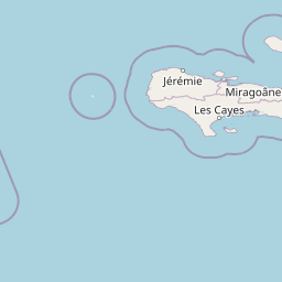
Map view of Grotte Marie-Jeanne

Use this park location map to pinpoint Grotte Marie-Jeanne in Finland, understand its exact geographic position, and read its mapped placement within the surrounding landscape more clearly.

Pigeon | © OpenStreetMap contributors
Park atlas

Compare adjacent subterranean formations and surrounding regional karst terrain

Exploring Parks Near Grotte Marie-Jeanne and Regional Protected Landscapes

Visitors concluding a tour of Grotte Marie-Jeanne can browse other regional protected areas and geological reserves. Comparing nearby parks expands geographic context across surrounding limestone landscapes and protected natural habitats.
National parkSud
About 11 km away#1 closest

Northeast

Parc national de Macaya: Mountain Geography and Protected Area Map of Southern Haiti

Cloud forest summits and hydrological landscapes in Sud

This protected area represents one of the most significant biodiversity reserves in the Caribbean. By safeguarding high-elevation cloud forests and steep mountain terrain within the Sud region, the park sustains rare endemic flora and vital watersheds that define the southern Haitian landscape.

Area
20 km²
Established
1983
IUCN
II
National parkHaiti
About 15 km away#2 closest

Northeast

Pic Macaya National Park: Haiti's Protected Cloud Forest and Mountain Geography

Explore critical endemic species within Haiti's mountainous protected areas.

Pic Macaya National Park stands as a significant natural sanctuary in Haiti, preserving the island's final remnants of virgin cloud forest within the challenging terrain of the Massif de la Hotte. This protected area is defined by its high-altitude volcanic and karstic landscape, including Pic Macaya, the second-highest peak in Haiti. The park is a crucial stronghold for biodiversity, harboring numerous species endemic to Hispaniola, making it an essential site for conservation and a focal point for understanding regional natural landscapes.

Area
80 km²
Established
1984
IUCN
II
Relief
Mountain
Protected areaHaiti
About 16 km away#3 closest

Northeast

Massif de la Hotte Protected Area: Geography, Mapped Ridges, and Haitian Mountain Terrain

Exploring the ecological architecture of the Tiburon Peninsula.

Massif de la Hotte serves as a pivotal mountainous protected area in southwestern Haiti, known for its dense cloud forest coverage and steep, rugged topography. This overview provides insight into the massif’s formation, its role as a regional biodiversity anchor, and its vertical landscape that rises sharply from the surrounding coastal lowlands.

Relief
Mountain
Scope
Terrestrial
Water
Minor water
Forest
Mostly forested
A watercolor illustration showing a band of lush green tropical foliage, ferns, and pink flowering plants against a soft, light background.
National parkSud
About 16 km away#4 closest

North

Parc national naturel de Grande Colline: Mountain Geography and Protected Area Atlas

A remote, high-altitude primary forest reserve in the Massif de la Hotte

Trace the boundaries of Parc national naturel de Grande Colline, an inaccessible mountain sanctuary characterized by deep ravines, cloud forests, and permanent rivers. As a central biodiversity site within Haiti, the terrain spans five major summits and protects key headwaters for the southern coastline. This atlas entry provides an overview of the park's geographic significance and primary forest habitat.

Area
15.1 km²
Established
2014
IUCN
II
Relief
Mountain
Watercolor painting of a mountainous landscape with green valleys and distant peaks.
National parkHaiti
About 17 km away#5 closest

North

Grande Colline National Park: Remote Haitian Mountain Protected Landscape

Unique cloud forest, giant tree ferns, and rugged terrain in Haiti.

Grande Colline National Park safeguards crucial montane cloud forest ecosystems in Haiti's Massif de la Hotte. Characterized by its five named peaks and steep ridges, this protected area preserves a landscape of towering tree ferns and intact hardwood forests above 1,800 meters. Its establishment highlights scientific exploration and the ongoing need for conservation in one of the Caribbean's most biodiverse regions, offering a unique glimpse into isolated montane geography.

Area
15.1 km²
Established
2014
IUCN
II
Relief
Mountain
National parkSud
About 25 km away#6 closest

Northwest

Grand Bois National Park National Park: Protected Mountain Landscape in Sud, Haiti

Discover Haiti's vital primary rainforest and endemic species refuge.

Grand Bois National Park is a critical conservation area in Haiti's Sud region, established to protect the rare primary rainforest ecosystem found on the isolated Morne Grand Bois peak. This national park safeguards approximately 3.7 square kilometers of mountainous terrain above 900 meters, featuring a unique cloud forest environment. It is a vital refuge for endemic species, including rediscovered amphibians and rare flora, making it a significant site for Caribbean biodiversity and landscape conservation. The park's importance lies in preserving one of Haiti's last intact forest ecosystems.

Area
3.7 km²
Established
2015
IUCN
II
Relief
Mountain
A horizontal watercolor painting depicting a soft-focus, layered view of green rolling hills and distant mountain ranges with hints of pale pink and yellow light.
National parkSud
About 25 km away#7 closest

Northwest

Parc national du Grand Bois: Geographic Profile and Protected Forest Boundaries

High-elevation montane terrain within the Sud department of Haiti

Parc national du Grand Bois protects an ecologically significant remnant of primary tropical and cloud forest on the isolated Morne Grand Bois peak. The park's steep, basin-like geography creates a unique refuge for endemic biodiversity and critical watershed protection in the Sud region, showcasing a distinct topographic boundary that contrasts sharply with the surrounding deforested slopes of the Tiburon Peninsula.

Area
3.702 km²
Established
2015
IUCN
II
National parkHaiti
About 27 km away#8 closest

Northwest

Deux Mamelles National Park: Protected Cloud Forest and Mountain Terrain in Haiti

Explore Haiti's critical highland cloud forest ecosystem.

Deux Mamelles National Park is a protected area in Haiti renowned for preserving one of the Caribbean's last remaining cloud forest ecosystems. Located on the Tiburon Peninsula, the park centers around Morne Deux Mamelles, a mountain rising to 1,276 meters. Its rugged, dissected limestone terrain supports primary forest at high elevations, making it a significant biodiversity hotspot and a key site for watershed protection. This park offers a glimpse into the unique natural heritage of Haiti's highlands.

Area
22.65 km²
Established
2015
IUCN
II
Relief
Mountain

Common questions about visiting, size, designation, and location context for Grotte Marie-Jeanne

Grotte Marie-Jeanne FAQs for park facts, access, geography, and protected area context

Find quick answers about Grotte Marie-Jeanne, including protected-area facts, park geography, trail and visitor context, and how the park fits into its surrounding country and regional landscape.
MoriAtlas Explorer

Continue Your Protected Areas Search Across the Global Atlas

Deepen your exploration by continuing the structured search for national parks and protected areas worldwide. Utilize the comprehensive filtering capabilities to compare different conservation landscapes and refine your understanding of global park geography. Discover more about the distribution and characteristics of protected natural areas.

Global natural geography