

Mori Atlas logo
National parkGugamal National Park

Discover the geographic identity of this Maharashtra national park and its conservation context.

Gugamal National Park: Mapped Boundaries and Protected Landscape in Maharashtra

Gugamal National Park stands as a key protected area within the diverse geography of Maharashtra, India. This national park offers a specific locus for understanding regional landscape patterns and the distribution of conservation lands across the Western Ghats. Explore its mapped boundaries and contribute to a structured atlas of India's protected natural areas.

tiger reservedry deciduous forestsatpura rangewildlife sanctuarycentral indiamaharashtra

Gugamal National Park

National park

Park overview

Structured park overview, official facts, and landscape profile for Gugamal National Park

Gugamal National Park park facts, protected area profile, and essential visitor context

Review the core facts for Gugamal National Park, including designation, size, terrain, visitor scale, habitats, and operating context in one park-focused overview.

About Gugamal National Park

Gugamal National Park is a substantial protected area in central India that serves as the ecological heart of the Melghat Tiger Reserve. Located in the Satpura Range of Maharashtra, the park protects a landscape of considerable topographic complexity, with steep ridges, deep valleys, and rocky plateaus creating a varied terrain that supports diverse habitats. The park's establishment in 1974 marked an important step in conserving the remaining wilderness of the Satpura hills, a mountain system that forms a critical biogeographic corridor connecting central Indian forests with the Western Ghats. Gugamal's protection status as a Category II IUCN protected area reflects its primary function as a national park preserving natural ecosystems and biodiversity. The park's location in the northern Western Ghats places it at the interface between moist evergreen forests to the south and the drier deciduous forests of the central Indian plateau, creating an ecological transition zone with distinctive species assemblages.

Quick facts and research context for Gugamal National Park

Gugamal National Park covers approximately 361 square kilometers in the Chikhaldara and Dharni tehsils of Amravati district, Maharashtra. The park was established on 22 February 1974 and forms part of the Melghat Tiger Reserve, a Project Tiger conservation initiative. The terrain is characterized by steep hills, deep valleys, and rocky outcrops typical of the Satpura Range. The forest type is southern dry tropical deciduous, dominated by teak and associated species. The park supports significant populations of Bengal tigers, Indian leopards, sloth bears, and Asian elephants, among other wildlife.

Protection and recognition

Documenting terrestrial management scope and official designations for conservation planning

Gugamal National Park Protection Status and Terrestrial Conservation Designations

Researchers and conservationists can analyze the official terrestrial protection status and documented geographic data established for Gugamal National Park. Tracking regional governance frameworks helps clarify the ecological significance of the reserve within the broader network of regional protected landscapes.

Protection details

Protection scope
Terrestrial
Transboundary protection
No
Park context

Deeper park guide and search-rich context for Gugamal National Park

Gugamal National Park history, landscape, wildlife, and travel context

Explore Gugamal National Park through its history, landscape character, ecosystems, wildlife, conservation priorities, cultural context, and seasonal travel timing in a structured park guide built for atlas discovery and search intent.

Why Gugamal National Park stands out

Gugamal National Park is best known as a core tiger habitat within the Melghat Tiger Reserve, supporting one of Maharashtra's key populations of Bengal tigers. The park's rugged hill forests also harbor substantial populations of Indian leopards and represent one of the westernmost strongholds for this large carnivore in central India. The park is notable for its diverse mammal community that includes sloth bears, Asian elephants, gaurs, and four-horned antelopes, as well as the reintroduction of crocodiles into its river systems.

White tiger with black stripes lying on ground with blurred green background
White tiger with distinct black stripes resting on the ground

Gugamal National Park history and protected-area timeline

Gugamal National Park was established on 22 February 1974 as part of Maharashtra's commitment to conserving its forest ecosystems and wildlife. The park was created as a core protected area within what would later become the Melghat Tiger Reserve, designated under India's Project Tiger conservation program. The formation of the park responded to growing recognition during the 1960s and early 1970s that the forests of the Satpura Range faced significant pressure from logging, hunting, and habitat conversion. The establishment of Gugamal provided legal protection to the most ecologically significant portion of the Melghat forests, creating a sanctuary where wildlife could exist with minimal human interference. Over the subsequent decades, the park has been managed as part of the integrated Melghat Tiger Reserve, which encompasses both core protected zones and surrounding buffer areas.

Gugamal National Park landscape and geographic character

The landscape of Gugamal National Park is defined by the rugged topography of the Satpura Range, characterized by steep, often nearly vertical hillsides, deep valleys carved by seasonal streams, and rocky plateaus that break the monotony of the forest cover. The elevation range creates distinct microclimates across the park, with higher ridges supporting different vegetation communities than the valley floors. The terrain is predominantly rocky, with exposed granite and basalt formations visible along hill faces and streambeds. The park's drainage network includes several perennial and seasonal rivers that flow through narrow gorges, creating riparian corridors through the forest. This physical landscape of steep terrain and rocky substrates has historically limited human settlement and agricultural development, contributing to the park's relatively intact forest character.

Gugamal National Park ecosystems, habitats, and plant life

The forest ecosystem of Gugamal National Park represents the southern dry tropical deciduous forest type, a vegetation classification that describes woodlands dominated by trees that lose their leaves during the dry winter season. The canopy is primarily composed of teak, a commercially valuable hardwood species that forms extensive pure stands in certain areas, interspersed with other tree species including ain, Indian gooseberry, lendia, dhawada, and kusum. Bamboo dominates the understory in many areas, forming dense thickets that provide important habitat for various species. The upper hill slopes support populations of orchids and strobilanthes, adding floral diversity to the forest. The park is also recognized for its medicinal plant resources, with several plant species of traditional therapeutic value occurring throughout the area. This forest structure supports the diverse mammal community that characterizes the park.

Gugamal National Park wildlife and species highlights

Gugamal National Park supports a remarkable diversity of mammalian wildlife, with the Bengal tiger and Indian leopard representing the apex predators of this ecosystem. The park's prey base supports these large carnivores through populations of sambar deer, cheetal (spotted deer), gaur (Indian bison), four-horned antelope, barking deer, nilgai, and wild boar. Other notable mammals include the sloth bear, Asian elephant, Ussuri dhole (wild dog), Indian jackal, honey badger, and flying squirrel. Primate species include langurs and rhesus monkeys, while macaques are also present. The park's aquatic habitats support populations of crocodiles, reintroduced systematically in 1990 and 1991, as well as approximately 25 fish species. The invertebrate fauna includes numerous butterfly species, adding to the park's biodiversity. This assemblage of wildlife reflects the park's role as a refuge for central India's forest-dependent species.

Gugamal National Park conservation status and protection priorities

Gugamal National Park functions as the core protected zone within the Melghat Tiger Reserve, one of India's premier tiger conservation landscapes. The park's protected status provides legal framework for preserving habitat essential to the survival of Bengal tigers and other threatened species. The Melghat region has been recognized as important for tiger conservation since the early 1970s, with the tiger reserve status providing additional resources and management focus. The reintroduction of crocodiles into the park's rivers demonstrates active wildlife management and habitat restoration efforts. The park's position in the northern Western Ghats places it within a region recognized for high endemism and biodiversity significance, making its conservation contribution extend beyond individual species to broader ecosystem preservation.

Gugamal National Park cultural meaning and human context

The landscape surrounding Gugamal National Park has been inhabited by local communities whose traditional practices have shaped the region's cultural landscape. The park lies in the tribal belt of Maharashtra, with indigenous communities having historical connections to the forests and natural resources of the Melghat region. These communities have historically practiced shifting cultivation and relied on forest products for their livelihoods, creating a complex relationship between human settlement and the natural environment that continues to influence conservation management in the region.

Top sights and standout views in Gugamal National Park

Gugamal National Park protects one of central India's most significant tiger habitats within the Melghat Tiger Reserve. The park's rugged hill forests support viable populations of Bengal tigers and leopards, making it a priority area for large carnivore conservation in Maharashtra. The diverse mammal community includes species such as Asian elephants, gaurs, and sloth bears, while the reintroduction of crocodiles demonstrates active ecological management. The park's forests represent the southern dry tropical deciduous type, with teak-dominated woodlands supporting a distinctive assemblage of flora and fauna.

Best time to visit Gugamal National Park

The optimal period to visit Gugamal National Park is during the cooler winter months from October through March, when temperatures are moderate and wildlife viewing opportunities are favorable. The post-monsoon period brings lush forest vegetation and accessible water sources that concentrate wildlife around remaining waterholes. Summer months from April through June can be extremely hot but offer excellent opportunities to observe wildlife as animals congregate at waterholes. The monsoon season from July through September brings heavy rainfall that can limit park accessibility and wildlife viewing.

Monthly climate preview

Long-term monthly temperature and precipitation data for Maharashtra

Gugamal National Park Climate Normals and Measured Temperature Patterns

Gugamal National Park exhibits a measured annual rhythm ranging from cooler baseline months to high summer maximum temperatures alongside distinct precipitation shifts. Examining the complete twelve-month record provides deeper insight into long-term climate normals across the protected landscape.
Annual mean26 °C
20 °C35 °C
Jan20°
Feb24°
Mar28°
Apr32°
May35°
Jun31°
Jul27°
Aug25°
Sep25°
Oct24°
Nov22°
Dec20°
Warmest month
May

34.6 °C

Coolest month
January

20.4 °C

Wettest month
July

9.7 mm/day

Driest month
December

0.2 mm/day

Park location guide

Geography guide, regional context, and park location map for Gugamal National Park

Gugamal National Park park geography, regions, and map view in India

Understand where Gugamal National Park sits in India through a broader geographic reading of the surrounding landscape, nearby location context, and its mapped position within the national park landscape.

How Gugamal National Park fits into India

India is a South Asian country bordered by the Indian Ocean, Arabian Sea, and Bay of Bengal. It shares land borders with Pakistan, China, Nepal, Bhutan, Bangladesh, and Myanmar. The country has a population of over 1.4 billion people and operates as a federal parliamentary republic with its capital in New Delhi.

Wider geography shaping Gugamal National Park in India

India occupies the Indian subcontinent in South Asia, bordered by the Arabian Sea to the southwest, the Bay of Bengal to the southeast, and the Indian Ocean to the south. It shares land borders with Pakistan to the west, China, Nepal, and Bhutan to the north, and Bangladesh and Myanmar to the east. The territory also includes the Andaman and Nicobar Islands in the Indian Ocean.

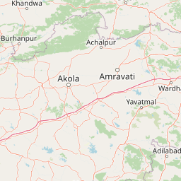
Map view of Gugamal National Park

Use this park location map to pinpoint Gugamal National Park in India, understand its exact geographic position, and read its mapped placement within the surrounding landscape more clearly.

Pigeon | © OpenStreetMap contributors

Location context for Gugamal National Park

Maharashtra

Visual Guide to Gugamal's Hill Forests, Riverine Habitats, and Central India's Protected Terrain

Gugamal National Park Photos: Explore the Rugged Landscapes and Dry Deciduous Forest Scenery

Browse an extensive collection of Gugamal National Park images to visually understand its diverse landscapes, rugged Satpura Range terrain, and critical dry tropical deciduous forest habitats. These park photos offer essential insight into the protected area's scenery, revealing the unique environment that supports its significant populations of Bengal tigers and leopards.

White tiger with black stripes lying on ground with blurred green background

Park atlas

Trace the regional geography of protected areas and compare adjacent conservation landscapes in Central India, expanding beyond Gugamal National Park.

Compare National Parks Near Gugamal National Park: Discover Protected Areas of the Satpura Range

Browse national parks and significant protected areas located in the vicinity of Gugamal National Park, including other core components of India's central wildlife conservation network. Comparing these adjacent protected landscapes provides essential geographic context and deeper insight into the varied ecosystems and conservation efforts across the Satpura Range and Deccan Plateau.
National parkIndia
About 164 km away#1 closest

Northeast

Satpura National Park: India's National Park for Protected Landscape Discovery

Explore mapped boundaries and regional geographic context.

Satpura National Park represents a significant protected area within India, offering valuable insights for geographic and atlas exploration. As a designated national park, its mapped boundaries and landscape character are central to understanding its protected status. This entry provides a focused view on Satpura National Park, highlighting its contribution to the atlas of protected lands in India and its distinct geographic identity for researchers and explorers.

Area
524 km²
Established
1981
Relief
Mountain
Climate
Subtropical
Natural monumentMaharashtra
About 170 km away#2 closest

Southwest

Lonar Lake Natural Monument: Geological Impact Crater and Protected Landscape in Maharashtra

Mapping the unique saline basin of an Indian impact site

Lonar Lake stands as an exceptional geological feature on the Deccan Plateau, formed by a massive meteorite impact that created a symmetric crater basin. This protected site features saline soda waters and distinct microbial ecosystems nestled within steep, forested slopes. The area encompasses both a rare natural landmark and a significant cultural heritage zone, providing a unique focus for geographic and scientific exploration in western India.

Area
1.13 km²
Established
2000
Relief
Upland
Climate
Tropical
National parkMadhya Pradesh
About 203 km away#3 closest

North

Van Vihar National Park: National Park Protected Landscape and Regional Geography

Mapped boundaries within Madhya Pradesh's natural context.

Van Vihar National Park is a designated national park offering a unique perspective on protected landscapes within Madhya Pradesh. This detail entry provides essential geographic context, focusing on the park's mapped boundaries and its role within the region's natural terrain. It serves as a vital point for understanding the distribution and identity of protected areas for atlas exploration.

Area
4.48 km²
Established
1979
IUCN
II
Visitors
250K annual
National parkMadhya Pradesh
About 225 km away#4 closest

East

Pench National Park: Madhya Pradesh National Park Protected Landscape Overview

Mapped geographic context and protected area boundaries

Pench National Park is a designated national park situated in Madhya Pradesh, India, offering a distinct protected landscape for geographic study. This entry provides detailed insights into its mapped terrain, allowing for an atlas-style exploration of its protected boundaries and its significance within the regional geography. Understand the park's place in the landscape and its value for conservation-focused map exploration.

Area
292.85 km²
Established
1983
IUCN
II
Relief
Upland
National parkMadhya Pradesh
About 266 km away#5 closest

Northwest

Dinosaur Fossils National Park: Protected Area and National Park in Madhya Pradesh

Explore mapped boundaries and regional geography.

Dinosaur Fossils National Park stands as a distinct national park within Madhya Pradesh, offering a unique focus for geographic exploration. This entry provides essential details about its protected status, mapped landscape features, and its place within India's network of conservation areas. Engage with structured data that details the park's regional context and natural terrain for comprehensive atlas-based understanding.

Area
0.894 km²
Established
2011
IUCN
II
Relief
Lowland
National parkChandrapur district
About 266 km away#6 closest

Southeast

Tadoba Andhari Tiger Reserve National Park: Mapped Protected Landscape Discovery

Geographic context within Chandrapur district, India.

Investigate Tadoba Andhari Tiger Reserve as a national park, focusing on its distinct protected landscape characteristics. This detail page provides structured insights into its mapped boundaries and its position within the regional geography of Chandrapur district, essential for a comprehensive understanding of India's protected natural areas.

Area
1,727.59 km²
Established
1955
IUCN
II
Relief
Highland
National parkMaharashtra
About 312 km away#7 closest

East

Navegaon National Park: Maharashtra's Designated National Park for Atlas Exploration

Mapped protected area and regional landscape context.

Navegaon National Park is a designated national park offering rich opportunities for geographic discovery. Users can delve into its mapped boundaries and understand its protected landscape character within Maharashtra. This page provides structured data for exploring the park's role as a conservation area and its contribution to the natural geography of the region, ideal for atlas-based research.

Area
1,894.94 km²
Established
1975
IUCN
II
Visitors
50K annual
Wildlife reserveMaharashtra
About 362 km away#8 closest

Southwest

Nandur Madhameshwar Bird Sanctuary: Maharashtra Wetland Geography and Protected Lands

Exploring the Godavari River floodplain and riparian bird habitats

Nandur Madhameshwar Bird Sanctuary sits as a pivotal protected wetland in Maharashtra, characterized by a shifting mosaic of marshes, scrub, and seasonal waterbodies. This wildlife reserve offers essential insights into the riparian ecology of the Godavari River basin, providing a mapped look at one of India's most significant inland bird habitats.

Area
100.12 km²
Established
1986
IUCN
IV
Relief
Lowland

Common questions about visiting, size, designation, and location context for Gugamal National Park

Gugamal National Park FAQs for park facts, access, geography, and protected area context

Find quick answers about Gugamal National Park, including protected-area facts, park geography, trail and visitor context, and how the park fits into its surrounding country and regional landscape.
MoriAtlas Explorer

Continue Your Protected Areas Search Across the Global Atlas

Deepen your exploration by continuing the structured search for national parks and protected areas worldwide. Utilize the comprehensive filtering capabilities to compare different conservation landscapes and refine your understanding of global park geography. Discover more about the distribution and characteristics of protected natural areas.

Global natural geography