Mori Atlas logo
National parkGuindy National Park

Explore the mapped boundaries and natural terrain of this national park within South India.

Guindy National Park: Protected Landscape Identity and Geographic Context in Tamil Nadu

Guindy National Park stands as a vital protected area within Tamil Nadu, India, offering a unique focal point for understanding regional geography and landscape context. This park serves as a key entity for atlas-based exploration, detailing its specific protected land boundaries and its place within the South Indian geographical framework. Discover the natural terrain and conservation landscape that define Guindy National Park through structured geographic data.

Urban national parkDry evergreen forestWildlife sanctuaryBirdwatching destinationBlackbuck habitatProtected area in Chennai

Guindy National Park

National park

Park overview

Structured park overview, official facts, and landscape profile for Guindy National Park

Guindy National Park park facts, protected area profile, and essential visitor context
Review the core facts for Guindy National Park, including designation, size, terrain, visitor scale, habitats, and operating context in one park-focused overview.

About Guindy National Park

Guindy National Park occupies a distinctive position among India's protected areas as one of the smallest and most centrally located national parks within a major urban center. The park's terrain consists of a heterogeneous landscape combining rolling terrain with exposed rocky outcrops, scrub-covered slopes, and grassy clearings interspersed with water bodies. The dry evergreen scrub and thorn forest vegetation represents a distinctive ecological type adapted to the semi-arid conditions of the Coromandel coastal plains, characterized by drought-resistant trees and shrubs that have evolved to survive the extended dry periods typical of this region. Within the park's boundaries, visitors encounter a surprising diversity of habitats ranging from dense shrub thickets to open grasslands, from seasonal ponds to permanent tanks, creating a complex ecological mosaic that supports remarkable species richness despite the park's modest size. The park's location between the Indian Institute of Technology Madras campus and Raj Bhavan, combined with its perimeter wall completed in the late 1980s, has created a protected ecological island that allows wildlife to persist in proximity to dense human settlement. This urban protected area serves not only as a biodiversity reservoir but also as an educational resource for the millions of Chennai residents who can experience native ecosystems without traveling far from the city center.

Quick facts and research context for Guindy National Park

Guindy National Park spans 2.7 square kilometers in central Chennai and was established as a national park in 1978, having previously served as a game reserve since the early 1900s. The park supports over 350 plant species, more than 150 bird species, 14 mammal species including approximately 400 blackbucks and 2,000 spotted deer, and diverse reptile and invertebrate populations. Located adjacent to Raj Bhavan and the Indian Institute of Technology Madras campus, the park is enclosed by a 9.5-kilometer perimeter wall and contains two major tanks, Kathan Kollai and Appalam Kolam, in addition to smaller ponds. The Tamil Nadu Forest Department manages the park, which receives around 700,000 visitors annually.

Park context

Deeper park guide and search-rich context for Guindy National Park

Guindy National Park history, landscape, wildlife, and travel context
Explore Guindy National Park through its history, landscape character, ecosystems, wildlife, conservation priorities, cultural context, and seasonal travel timing in a structured park guide built for atlas discovery and search intent.

Why Guindy National Park stands out

Guindy National Park is best known for its remarkable concentration of blackbuck, a near-threatened antelope species that serves as the park's flagship conservation icon. The park also stands out for its urban location, sitting completely within Chennai's metropolitan area and functioning as a living laboratory where wildlife thrives alongside a major city. Its population of spotted deer, estimated at over 2,000 individuals, represents one of the densest concentrations of this species anywhere in India. The park's dry evergreen scrub forest ecosystem is increasingly rare along the Coromandel Coast, making it an important reservoir of native coastal biodiversity.

Guindy National Park history and protected-area timeline

The history of Guindy National Park reflects centuries of changing land use and governance that transformed a coastal forest into a protected urban sanctuary. The area originally formed part of a vast tract of tropical dry evergreen forest extending along the Coromandel Coast, one of the last remaining examples of this ecosystem type in northeastern Tamil Nadu. In the early 1670s, Governor William Langhorne established Guindy Lodge within the forest, creating a recreational retreat that marked the beginning of human modification of the landscape. The remaining forest area came under private ownership of Gilbert Rodericks before the Government of Madras purchased it in 1821 for the sum of ₹35,000. The area was formally declared a Reserve Forest in 1910, establishing its protected status under colonial administration. Between 1961 and 1977, approximately 172 hectares were transferred to various government departments for educational institutions and memorials, including land for the Indian Institute of Technology Madras in 1958 and areas for the Guindy Deer Park and Children's Park created under Prime Minister Jawaharlal Nehru's direction. Memorials to leaders Rajaji and Kamaraj were constructed in 1974 and 1975. The remaining forest area was transferred to the Tamil Nadu Forest Department in 1977, and the reserve was officially declared a national park in 1978. The park was walled off from adjacent Raj Bhavan and IIT Madras properties in the late 1980s, creating the secure boundary that exists today.

Guindy National Park landscape and geographic character

The physical landscape of Guindy National Park presents a varied topography of gentle slopes, rocky exposures, and low-lying areas that hold water during the monsoon season. The park's terrain rises modestly from surrounding areas, with exposed granite outcrops visible across several sections of the reserve. A prominent cleared meadow known as the Polo Field, measuring approximately 230 by 160 meters, breaks the forest cover and provides an open grassland habitat critical for blackbuck conservation. The park contains several water bodies including the Tangal Eri lake and two major tanks, Kathan Kollai and Appalam Kolam, which retain water through much of the year. Two additional smaller ponds typically dry up during the summer months. The entire park is enclosed by a perimeter wall stretching 9.5 kilometers, within which an extensive network of roads and trails covering approximately 14 kilometers provides access for management and visitor movement. The landscape transitions from denser scrub woodland in the northern sections to more open thorn forest and grassland in other areas, creating a heterogeneous environment that supports diverse ecological communities.

Guindy National Park ecosystems, habitats, and plant life

The ecological character of Guindy National Park centers on the dry evergreen scrub and thorn forest ecosystem that represents a distinctive vegetation type of the East Deccan coastal plains. The park supports over 350 species of plants including shrubs, climbers, herbs, and grasses, with more than 24 tree species documented within its boundaries. Key tree species include sugar-apple, Atlantia monophylla, wood-apple, and neem, while the scrub layer features species such as Carissa spinarum, Acacia chundra, and various Randia species. The tropical climate features mean maximum temperatures of 32.9°C and minimum temperatures of 24.3°C, with annual rainfall averaging 1,215 mm but varying widely from 522 mm to 2,135 mm depending on the monsoon. The summer season in April and May particularly influences the vegetation characteristics, while the wet season extends from June to December with a dry period between January and March. Approximately one-sixth of the park has been maintained as open grassland specifically to preserve habitat for blackbuck populations, creating a semi-natural savanna-like environment within the larger forest matrix.

Guindy National Park wildlife and species highlights

The wildlife community of Guindy National Park demonstrates remarkable diversity for an urban protected area, with more than 14 mammal species, over 150 bird species, nine amphibian species, numerous reptiles, and extensive invertebrate populations. The blackbuck, designated as the park's flagship species and classified as near-threatened, was introduced in 1924 by Freeman Freeman-Thomas, the then Viceroy of India, with additional albino individuals released by the Maharaja of Bhavnagar. The 2004 census recorded 405 blackbucks including individuals ranging into the adjacent IIT campus. The spotted deer, or chital, population has grown substantially and now numbers approximately 2,650 individuals including 1,743 females and 336 fawns. Other mammals include jackal, small Indian civet, common palm civet, bonnet macaque, hyena, pangolin, hedgehog, common mongoose, Indian palm squirrel, and Indian hare, along with various bat and rodent species. The bird community features both resident and migratory species, with residents including grey partridge, crow pheasant, parrot, quail, paradise flycatcher, black-winged kite, honey buzzard, golden-backed woodpecker, and various lapwings and malkohas. Migratory visitors arrive each fall including teals, garganeys, pochards, egrets, herons, and open-billed storks. Reptiles include saw-scaled viper, fan-throated lizard, Indian monitor lizard, various geckos, chameleons, and the endangered Indian star tortoise. Invertebrates are represented by approximately 60 spider species and 60 butterfly species.

Guindy National Park conservation status and protection priorities

Guindy National Park holds significant conservation importance as one of the last remaining fragments of tropical dry evergreen forest along the Coromandel Coast, representing a rapidly disappearing ecosystem type. The park's location within a metropolitan area makes it an important model for urban conservation, demonstrating that substantial biodiversity can persist in close proximity to dense human populations when properly protected. The population of blackbuck, classified as near-threatened, represents a conservation priority, and the park maintains what may be one of the most stable populations of this species in India. The park functions both for in-situ conservation of native species and as an ex-situ conservation facility through the adjacent Guindy Snake Park, which received statutory recognition as a medium zoo from the Central Zoo Authority of India in 1995. The Guindy Snake Park occupies 22 acres within the national park boundary and maintains populations of various reptile species including king cobra, pythons, and vipers. The habitat management approach, which maintains approximately one-sixth of the park as open grassland specifically for blackbuck, demonstrates active conservation planning that balances the needs of multiple species.

Guindy National Park cultural meaning and human context

Guindy National Park exists within a landscape of significant historical and administrative importance in Chennai. The park's northern boundary adjoins Raj Bhavan, the official residence of the Governor of Tamil Nadu, a relationship that extends back to the early history of the area when the forest served as grounds for the colonial administrator's residence. The park's name derives from the Guindy Lodge established by Governor William Langhorne in the 1670s, linking the protected area to over three centuries of administrative history in Chennai, then known as Madras. The creation of the Guindy Deer Park and Children's Park in 1958 under Prime Minister Jawaharlal Nehru's direction reflects the park's role as a public recreation and education space that continues today. The proximity of the Indian Institute of Technology Madras campus, established on land transferred from the forest in 1958, creates an unusual adjacency of higher education and conservation that offers research and educational opportunities. The children's park within the complex includes a fossilized tree specimen estimated at 20 million years old, adding a paleontological dimension to the site's educational offerings.

Top sights and standout views in Guindy National Park

Guindy National Park offers a rare combination of urban accessibility and natural diversity that makes it distinctive among India's protected areas. The park's blackbuck population, numbering around 400 individuals, provides excellent wildlife viewing opportunities in a setting where these graceful antelopes graze in plain view against an unexpected urban backdrop. The spotted deer population, exceeding 2,000 individuals, represents one of the densest concentrations of this species in any protected area. The bird diversity, with over 150 species including both residents and migratory visitors, makes the park a significant destination for birdwatchers within Chennai. The dry evergreen scrub forest ecosystem, increasingly rare along the Coromandel Coast, provides a window into a vanishing habitat type. The park's network of trails and roads, totaling approximately 14 kilometers, allows visitors to explore varied habitats from dense scrub to open grasslands to wetland areas, all within a compact area that can be comprehensively explored in a single visit.

Best time to visit Guindy National Park

Guindy National Park can be visited year-round, though the optimal period for wildlife viewing spans from October through March when migratory birds are present and temperatures are more comfortable for outdoor exploration. The monsoon season from June to December brings regular rainfall that fills the park's tanks and ponds, creating lush green conditions and excellent photography opportunities. The dry season from January through March reduces water availability in smaller ponds, concentrating wildlife around the permanent water bodies and potentially making animals easier to locate. Early morning visits offer the best chances for observing blackbucks and deer as they graze in the more open areas, while late afternoon walks allow visitors to see species becoming active as temperatures cool. The park remains open from 9 AM to 6 PM daily except Tuesday, and visitors can access the core area only when accompanied by a forest ranger. The adjacent Snake Park and Children's Park operate under separate entrances and have independent entry fees.
Park location guide

Geography guide, regional context, and park location map for Guindy National Park

Guindy National Park park geography, regions, and map view in India
Understand where Guindy National Park sits in India through a broader geographic reading of the surrounding landscape, nearby location context, and its mapped position within the national park landscape.

How Guindy National Park fits into India

India is a South Asian country bordered by the Indian Ocean, Arabian Sea, and Bay of Bengal. It shares land borders with Pakistan, China, Nepal, Bhutan, Bangladesh, and Myanmar. The country has a population of over 1.4 billion people and operates as a federal parliamentary republic with its capital in New Delhi.

Wider geography shaping Guindy National Park in India

India occupies the Indian subcontinent in South Asia, bordered by the Arabian Sea to the southwest, the Bay of Bengal to the southeast, and the Indian Ocean to the south. It shares land borders with Pakistan to the west, China, Nepal, and Bhutan to the north, and Bangladesh and Myanmar to the east. The territory also includes the Andaman and Nicobar Islands in the Indian Ocean.

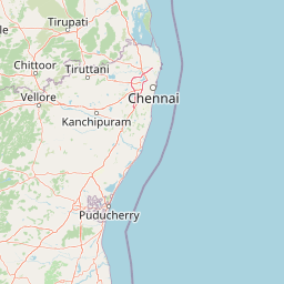
Map view of Guindy National Park

Use this park location map to pinpoint Guindy National Park in India, understand its exact geographic position, and read its mapped placement within the surrounding landscape more clearly.

Pigeon | © OpenStreetMap contributors

Location context for Guindy National Park

Tamil Nadu
Park atlas

Map the regional spread of conservation landscapes and compare protected areas surrounding Guindy National Park, India.

Explore Nearby National Parks and Protected Areas Beyond Guindy National Park's Urban Core
Beyond Guindy National Park, explore additional national parks and protected areas to understand the broader conservation landscape of India and its diverse ecological regions. This geographic context allows for comparing urban green spaces with wider protected areas, tracing regional habitat types, and discovering more park entities in the surrounding terrain.
National parkAndhra Pradesh

Sri Venkateswara National Park: Andhra Pradesh National Park Protected Landscape Atlas

Mapped protected area, regional geography, and natural terrain.

Uncover the core geographic identity of Sri Venkateswara National Park, a designated national park within Andhra Pradesh. This resource delves into its protected landscape features, providing a mapped perspective on its boundaries and natural terrain. It serves as a crucial point for understanding the park's regional context and its significance as a mapped natural area for atlas-based exploration.

Area
353 km²
Established
1989
IUCN
II
Relief
Mountain
National parkAndhra Pradesh

Rajiv Gandhi National Park (Rameswaram) National Park: Exploring Andhra Pradesh's Protected Landscapes

Mapped geography and protected area context for Rajiv Gandhi National Park (Rameswaram).

Delve into the geographic identity of Rajiv Gandhi National Park (Rameswaram), a key protected area within Andhra Pradesh. This detail page serves as an atlas anchor for understanding the park's landscape, mapped features, and its significance as a national park. Users can explore its protected boundaries and appreciate its role within the regional geography of Andhra Pradesh.

Area
2.4 km²
Established
2005
IUCN
II
Relief
Lowland
Watercolor illustration showing mountains, a winding river, and green vegetation
National parkKarnataka

Bannerghatta National Park: A National Park in Karnataka with Mapped Geographic Identity

Explore the protected landscape and regional terrain context.

Bannerghatta National Park is an important protected area within the state of Karnataka, India. Its designation as a national park signifies its role in preserving regional natural landscapes and providing valuable geographic context for atlas exploration. Users can examine its mapped boundaries and understand its placement within the diverse terrain characteristic of South India and the Western Ghats, contributing to a structured understanding of protected lands.

Area
260.51 km²
Established
1974
IUCN
II
Relief
Mountain
National parkNorthern Province

Chundikkulam National Park: Protected Landscape Identity and Geographic Atlas

Mapped park boundaries within Northern Province's regional geography.

Chundikkulam National Park stands as a protected landscape within Sri Lanka's Northern Province. This atlas entry provides structured details on its protected area status, allowing for a clear understanding of its geographic position and mapped boundaries. Explore the contextual geography and natural landscape features that define this significant national park, offering a factual basis for discovery.

Area
196 km²
Established
2015
IUCN
II
Relief
Lowland
National parkNorthern Province

Delft National Park: Exploring Its Protected Landscape and Geographic Setting in Northern Province

Mapped boundaries and regional atlas context for this national park.

Delft National Park is a protected natural area situated in Sri Lanka's Northern Province, designated as a national park. This page offers an atlas-focused view of its protected boundaries, helping to contextualize its geographic setting and landscape character. Understanding Delft National Park involves exploring its specific location within the Northern Province and its role as a distinct entity in the study of mapped natural environments and regional geography.

Area
18.46 km²
Established
2015
IUCN
II
Relief
Lowland
National parkKarnataka

Bandipur National Park: Karnataka's Protected Landscape and National Park Atlas Entry

Discover mapped terrain and diverse forest ecosystems in South India.

Bandipur National Park, a prominent national park within Karnataka, serves as a vital hub for understanding protected area geography and landscape diversity. Its ecological significance is amplified by its location at the intersection of the Deccan Plateau and the Western Ghats, supporting a unique blend of forest types and rich biodiversity. This entry provides essential context for atlas-based discovery, detailing the park's mapped terrain, its role as a tiger reserve, and its contribution to the Nilgiri Biosphere Reserve's conservation landscape.

Area
1,456.3 km²
Established
1973
IUCN
II
Relief
Mixed relief
Watercolor painting showing green fields, pink and yellow areas, and distant mountains
National parkNilgiri District

Mudumalai National Park: National Park Identity and Geographic Context in Nilgiri District

Mapped protected area and natural terrain details for this key Indian park.

Delve into the specific geographic identity of Mudumalai National Park, a protected national park situated in the Nilgiri District. This detail page provides access to its mapped natural landscape, helping users understand its protected boundaries and regional geographic significance. It serves as a foundational point for exploring the park's unique terrain within India's atlas of natural protected areas.

Area
321 km²
Established
1940
IUCN
II
Relief
Mountain
National parkTamil Nadu

Gulf of Mannar Marine National Park: Protected Island Archipelago and Marine Atlas

Explore India's vital marine national park and its coral reef ecosystems.

Gulf of Mannar Marine National Park is a designated national park located in Tamil Nadu, India, protecting a chain of 21 islands and their surrounding marine environments. This protected area is renowned for its extensive coral reefs, crucial seagrass meadows supporting dugongs, and diverse fish species, making it a key site for marine conservation and geographic exploration. The park's unique island landscape and intertidal zones offer a distinct perspective on coastal protected areas within the Indian Ocean, providing rich material for atlas-style discovery and understanding regional marine geography.

Area
560 km²
Established
1986
IUCN
II
Relief
Lowland

Common questions about visiting, size, designation, and location context for Guindy National Park

Guindy National Park FAQs for park facts, access, geography, and protected area context
Find quick answers about Guindy National Park, including protected-area facts, park geography, trail and visitor context, and how the park fits into its surrounding country and regional landscape.
MoriAtlas Explorer

Continue Your Protected Areas Search Across the Global Atlas

Deepen your exploration by continuing the structured search for national parks and protected areas worldwide. Utilize the comprehensive filtering capabilities to compare different conservation landscapes and refine your understanding of global park geography. Discover more about the distribution and characteristics of protected natural areas.

Global natural geography