Mori Atlas logo
Wildlife reserveNelapattu Bird Sanctuary

Explore the unique geography of this wildlife reserve, defined by freshwater swamp forest and dry evergreen scrub.

Nelapattu Bird Sanctuary and Protected Wetland Landscapes in Tirupati District, India

Nelapattu Bird Sanctuary represents a critical inland wetland complex located within the Tirupati district of southern India. This protected wildlife reserve encompasses a rare combination of seasonally flooded Barringtonia forest and southern dry evergreen scrub. The landscape provides essential habitats for waterbird colonies and migratory species, serving as a significant site for avian conservation within the regional geography of Andhra Pradesh.

bird sanctuarywetlandswamp forestpelican colonymigratory birdswaterbirds

Nelapattu Bird Sanctuary

Wildlife reserve

Park overview

Structured park overview, official facts, and landscape profile for Nelapattu Bird Sanctuary

Nelapattu Bird Sanctuary park facts, protected area profile, and essential visitor context

Review the core facts for Nelapattu Bird Sanctuary, including designation, size, terrain, visitor scale, habitats, and operating context in one park-focused overview.

About Nelapattu Bird Sanctuary

Nelapattu Bird Sanctuary protects approximately 459 hectares of land in Tirupati district, in the southern Indian state of Andhra Pradesh. Located near the village of Nelapattu, it has been a designated bird sanctuary since 1976 and operates as a habitat and species management area under the IUCN framework.

The sanctuary's defining feature is the Nelapattu tank, a freshwater reservoir whose margins are lined by a rare example of Barringtonia acutangula swamp forest. This tree-dominated flooded forest is ecologically unusual in the Deccan landscape because it tolerates prolonged submersion during the wet season, allowing saplings to survive total inundation for months at a time. Surrounding this wetland core is a matrix of southern dry evergreen scrub characteristic of the East Deccan dry evergreen forests ecoregion, including reserved forest areas such as the Kalluru Reserved Forest.

Birdlife is exceptionally rich at Nelapattu, with roughly 189 species recorded, of which approximately 50 are migratory. Beyond its pelican colony, the site supports breeding populations of black-headed ibis, Asian openbill, black-crowned night heron, and little cormorant, while winter visitors include northern pintail, common teal, garganey, gadwall, and several heron and cormorant species. The sanctuary therefore serves both as a year-round refuge for resident waterbirds and as a seasonal stronghold for migrants moving through peninsular India.

Quick facts and research context for Nelapattu Bird Sanctuary

Nelapattu Bird Sanctuary is located in Tirupati district, Andhra Pradesh, southern India, and covers approximately 459 hectares. It was established in 1976 and is classified as an IUCN Category IV protected area focused on habitat and species management.

The sanctuary combines two principal plant communities: southern dry evergreen scrub across most of its land area, and Barringtonia-dominated swamp forest around the Nelapattu tank. The site supports around 189 recorded bird species, including roughly 50 migratory species, and is particularly significant for colonial nesting waterbirds such as the spot-billed pelican.

Protection and recognition

Examine the terrestrial protection scope and documented designation history.

Nelapattu Bird Sanctuary Protection Status and Conservation Recognition

Nelapattu Bird Sanctuary maintains a documented terrestrial protection scope within its designated reserve boundary. Verification records outline the management framework and associated conservation recognition data available for this protected area.

Protection details

Protection scope
Terrestrial
Transboundary protection
No
Park context

Deeper park guide and search-rich context for Nelapattu Bird Sanctuary

Nelapattu Bird Sanctuary history, landscape, wildlife, and travel context

Explore Nelapattu Bird Sanctuary through its history, landscape character, ecosystems, wildlife, conservation priorities, cultural context, and seasonal travel timing in a structured park guide built for atlas discovery and search intent.

Why Nelapattu Bird Sanctuary stands out

Nelapattu is best known as one of the most important inland breeding colonies of the spot-billed pelican in India, a species whose nesting numbers have declined sharply across much of South and Southeast Asia. Colonies of pelicans nesting in the canopy of the Barringtonia swamp forest give the sanctuary its identity. Equally important is the sanctuary's mixture of forested and aquatic habitats within a compact area. The juxtaposition of southern dry evergreen scrub on the surrounding ridges with seasonally flooded Barringtonia forest along the reservoir edge creates a distinctive dual-habitat setting that supports both breeding waterbirds and a diverse community of dry-country woodland species.
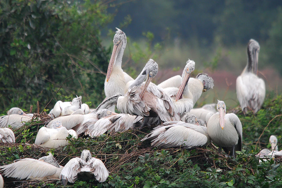
Several white and grey spot-billed pelicans resting and preening in a dense green leafy nest area.
A group of spot-billed pelicans nesting in the vegetation at Nelapattu Bird Sanctuary.

Nelapattu Bird Sanctuary history and protected-area timeline

Nelapattu Bird Sanctuary was formally established in 1976, giving formal protected status to a site that had long been valued locally for its birdlife. Its designation reflected growing awareness during the 1970s of the importance of inland wetlands for waterbird conservation in southern India, particularly for species such as the spot-billed pelican, whose breeding colonies had become increasingly scarce across the country.

Over time, the sanctuary has come to be recognized as one of the key inland strongholds for spot-billed pelican breeding in India. Conservation attention has focused on protecting the Barringtonia swamp forest around the Nelapattu tank, since the nesting trees used by pelicans are central to the site's reproductive output. The sanctuary continues to operate as a habitat and species management area under the IUCN protected-area framework.

Nelapattu Bird Sanctuary landscape and geographic character

The landscape of Nelapattu Bird Sanctuary is defined by the contrast between open water and dry forested uplands, an unusual pairing for an inland sanctuary in the Deccan. The central feature is the Nelapattu tank, a roughly 83-hectare reservoir that fills during the monsoon and gradually draws down through the dry months.

Surrounding the tank are low ridges and flats clothed in southern dry evergreen scrub, the characteristic vegetation of the East Deccan dry evergreen forests. This vegetation includes substantial reserved forest areas, notably the 288-hectare Kalluru Reserved Forest, alongside smaller patches of unreserved forest. The terrain is gently undulating rather than mountainous, giving broad visibility across the scrub and allowing large waterbirds to move easily between the wetland and the surrounding woodland.

The transition zone between the tank and the scrub is particularly distinctive. Here, Barringtonia acutangula forms a narrow but ecologically rich swamp forest that can tolerate months of standing water, producing a flooded woodland habitat rarely encountered in this region of India.

Nelapattu Bird Sanctuary ecosystems, habitats, and plant life

Nelapattu's ecological character arises from the close coexistence of two very different plant communities within a small protected area. The dominant community across most of the sanctuary is southern dry evergreen scrub, featuring trees and shrubs such as Manilkara hexandra, Maba buxifolia, Memecylon edule, Buchanania angustifolia, and Zizyphus xylopyrus. This vegetation is well adapted to the seasonally dry climate of the eastern Deccan and supports a community of woodland birds typical of the region.

Around the reservoir, however, conditions shift dramatically. The Nelapattu tank supports a freshwater swamp forest dominated by Barringtonia acutangula, locally known as Hijal. Although this species also grows on dry uplands elsewhere, the population at Nelapattu is remarkable for tolerating extended flooding of five to seven months, with saplings capable of surviving complete submersion during the highest water levels. This flood tolerance underpins the site's role as a heronry and pelicanry, since the trees provide both nest sites and protection from ground-based predators.

Together these two communities form a mosaic of dry scrub, swamp forest, open water, and seasonal marsh that sustains both resident species and visiting migrants through the year.

Nelapattu Bird Sanctuary wildlife and species highlights

Wildlife interest at Nelapattu centers overwhelmingly on birds, for which the sanctuary is internationally recognized. Around 189 bird species have been recorded, including roughly 50 migratory species that arrive during the winter months.

The sanctuary's signature species is the spot-billed pelican, which breeds colonially in the Barringtonia trees around the Nelapattu tank. The site is one of the most important inland breeding locations for this near-threatened species in India. Equally significant are breeding populations of black-headed ibis, Asian openbill, black-crowned night heron, and little cormorant, all of which share the swamp forest as their nesting habitat.

Migratory waterbirds add a strong seasonal character to the sanctuary during winter. Regular visitors include northern pintail, common teal, garganey, gadwall, northern shoveler, Indian spot-billed duck, little grebe, Eurasian coot, grey heron, Oriental darter, and black-winged stilt, expanding the site's ornithological importance well beyond its breeding season.

Nelapattu Bird Sanctuary conservation status and protection priorities

Nelapattu Bird Sanctuary plays an unusually focused conservation role for a relatively small protected area. Its principal significance lies in safeguarding one of the most important inland breeding colonies of the spot-billed pelican, a species whose population has declined sharply across parts of its range due to habitat loss, disturbance at nesting sites, and degradation of wetland feeding areas.

By protecting a large block of Barringtonia swamp forest around the Nelapattu tank alongside surrounding dry scrub habitat, the sanctuary preserves both the nesting trees that pelicans depend on and the broader landscape that supports their foraging and roosting behavior. The presence of multiple additional breeding colonial waterbirds, including black-headed ibis and Asian openbill, adds further conservation value by maintaining replicated nesting habitat under formal protection.

As an IUCN Category IV habitat and species management area, Nelapattu is also positioned to act as a regional reference site for monitoring the status of inland wetland bird communities in the southern Deccan and for designing interventions that benefit waterbirds sharing similar habitats elsewhere in Andhra Pradesh.

Top sights and standout views in Nelapattu Bird Sanctuary

Nelapattu's strongest highlight is its combination of pelican-friendly swamp forest and dry-country scrub within a single protected landscape. The 83-hectare Nelapattu tank and its surrounding Barringtonia trees form one of the most important inland breeding sites for spot-billed pelicans in India, and the same trees host mixed colonies of ibises, openbills, night herons, and little cormorants.

Beyond the breeding season, the sanctuary's mix of open water, flooded woodland, and southern dry evergreen scrub attracts roughly 50 migratory species, including northern pintail, garganey, common teal, and Oriental darter. Few protected areas in the eastern Deccan combine this range of breeding and wintering functions at such a compact scale.

Best time to visit Nelapattu Bird Sanctuary

Nelapattu offers a layered seasonal experience. The post-monsoon and winter months, broadly from late October through February, are typically associated with the largest numbers of migratory waterfowl and with comfortable weather for observation, making this the most rewarding window for seeing the full breadth of the sanctuary's bird list.

The breeding season, broadly coinciding with the months when the tank holds water and the Barringtonia canopy is in active use, is when the pelican and heron colonies are most visible. Visiting during this period offers the chance to observe colonial nesting behavior, while the later winter and early dry season tends to emphasize migrant diversity and gradually decreasing water levels.

Monthly climate preview

Long-term monthly temperature and precipitation patterns across representative coordinates

Nelapattu Bird Sanctuary Climate Normals and Annual Temperature Rhythm

Nelapattu Bird Sanctuary exhibits recorded mean temperatures spanning from twenty-four to over thirty-two degrees alongside distinct monthly precipitation variations across the year. Reviewing the complete twelve-month temperature and precipitation profile provides deeper insight into long-term climate normals for this protected area.
Annual mean28 °C
24 °C32 °C
Jan24°
Feb26°
Mar28°
Apr31°
May32°
Jun31°
Jul30°
Aug29°
Sep29°
Oct28°
Nov26°
Dec24°
Warmest month
May

32.4 °C

Coolest month
January

24 °C

Wettest month
November

9.2 mm/day

Driest month
March

0.2 mm/day

Park location guide

Geography guide, regional context, and park location map for Nelapattu Bird Sanctuary

Nelapattu Bird Sanctuary park geography, regions, and map view in India

Understand where Nelapattu Bird Sanctuary sits in India through a broader geographic reading of the surrounding landscape, nearby location context, and its mapped position within the national park landscape.

How Nelapattu Bird Sanctuary fits into India

India is a South Asian country bordered by the Indian Ocean, Arabian Sea, and Bay of Bengal. It shares land borders with Pakistan, China, Nepal, Bhutan, Bangladesh, and Myanmar. The country has a population of over 1.4 billion people and operates as a federal parliamentary republic with its capital in New Delhi.

Wider geography shaping Nelapattu Bird Sanctuary in India

India occupies the Indian subcontinent in South Asia, bordered by the Arabian Sea to the southwest, the Bay of Bengal to the southeast, and the Indian Ocean to the south. It shares land borders with Pakistan to the west, China, Nepal, and Bhutan to the north, and Bangladesh and Myanmar to the east. The territory also includes the Andaman and Nicobar Islands in the Indian Ocean.

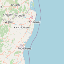
Map view of Nelapattu Bird Sanctuary

Use this park location map to pinpoint Nelapattu Bird Sanctuary in India, understand its exact geographic position, and read its mapped placement within the surrounding landscape more clearly.

Pigeon | © OpenStreetMap contributors

Location context for Nelapattu Bird Sanctuary

Andhra PradeshTirupati district

Visual reference for dry evergreen scrub, swamp forests, and wetland habitats

Nelapattu Bird Sanctuary Photos, Landscapes, and Protected Area Scenery

Visual documentation captures the distinctive terrain, open water reservoirs, and flooded swamp forest communities defining Nelapattu Bird Sanctuary. Examining these protected area views reveals the ecological transition zones supporting major inland waterbird breeding colonies.

Several white and grey spot-billed pelicans resting and preening in a dense green leafy nest area.

Park atlas

Compare regional wetlands, scrub forests, and surrounding wildlife habitats

Explore Protected Areas and Parks Near Nelapattu Bird Sanctuary

Browsing parks near Nelapattu Bird Sanctuary reveals diverse inland wetland complexes and dry evergreen scrub reserves across the southern Deccan landscape. Extending the search helps connect isolated sanctuary habitats with broader regional conservation networks and surrounding protected terrain.
Wildlife reserveAndhra Pradesh
About 38 km away#1 closest

Southeast

Pulicat Lake Bird Sanctuary: Coastal Wetland and Wildlife Reserve in Andhra Pradesh

Mapped landscapes and protected brackish water habitats

Explore the expansive Pulicat Lake Bird Sanctuary, an essential coastal wetland ecosystem in Andhra Pradesh. This wildlife reserve features a vast brackish lagoon, mudflats, and salt-tolerant vegetation, serving as a primary refuge for migratory waterbirds along the southeastern coast of India.

Area
759 km²
Established
1976
IUCN
IV
Relief
Lowland
Wildlife reserveAndhra Pradesh
About 55 km away#2 closest

West

Sri Penusila Narasimha Wildlife Sanctuary: Geographic Atlas and Protected Area Context

Protected dry evergreen forests of the Eastern Ghats transition zone.

Sri Penusila Narasimha Wildlife Sanctuary stands as a key protected area in Andhra Pradesh, known for its rare dry evergreen forest formation and status as a habitat for tigers, leopards, and the critically endangered Jerdon's courser. The sanctuary's undulating terrain of hills and valleys forms a complex mosaic of sheltered basins that provide essential refuge for both large mammals and endemic ground birds across the Eastern Ghats.

Area
1,030.85 km²
IUCN
IV
Relief
Mountain
Scope
Terrestrial
National parkAndhra Pradesh
About 66 km away#3 closest

West

Sri Venkateswara National Park: Andhra Pradesh National Park Protected Landscape Atlas

Mapped protected area, regional geography, and natural terrain.

Uncover the core geographic identity of Sri Venkateswara National Park, a designated national park within Andhra Pradesh. This resource delves into its protected landscape features, providing a mapped perspective on its boundaries and natural terrain. It serves as a crucial point for understanding the park's regional context and its significance as a mapped natural area for atlas-based exploration.

Area
353 km²
Established
1989
IUCN
II
Relief
Mountain
National parkTamil Nadu
About 95 km away#4 closest

South

Guindy National Park: Exploring its Protected Area Identity and Geographic Setting in Tamil Nadu

National park terrain and mapped boundaries for regional context.

Guindy National Park represents a significant protected natural landscape within Tamil Nadu, India. This entry provides detailed geographic context, focusing on the park's mapped boundaries and its identity as a national park. Users can delve into the regional landscape, understanding how Guindy National Park contributes to the atlas of protected areas in South India and appreciating its specific natural terrain.

Area
2.706 km²
Established
1977
IUCN
II
Visitors
700K annual
Watercolor illustration showing a landscape with rolling green hills, pale mountains in the background, and clusters of trees in soft shades of green and pink on the sides.
Wildlife reserveAndhra Pradesh
About 142 km away#5 closest

Northwest

Sri Lankamalleswara Wildlife Sanctuary: Protected Geography and Forest Landscapes

A critical dry forest refuge in Andhra Pradesh, India

Located in the Eastern Ghats, Sri Lankamalleswara Wildlife Sanctuary provides a critical sanctuary for the rare Jerdon's courser. The landscape features deep gorges, rocky outcrops, and dry deciduous thorn forests that remain essential for maintaining the ecological integrity of Andhra Pradesh. This protected area represents one of the most distinctive dry-forest systems in the southern part of India.

Area
464.42 km²
IUCN
IV
Relief
Upland
Access
Access unknown
A pale, soft-focus watercolor illustration depicting rolling hills, sparse trees, and a light sky, arranged as a wide panoramic strip.
Wildlife reserveAndhra Pradesh
About 166 km away#6 closest

Southwest

Koundinya Wildlife Sanctuary: Mapped Landscapes and Protected Area Geography in Andhra Pradesh

Essential insights into regional elephant habitat and plateau ecosystems

Koundinya Wildlife Sanctuary serves as the primary elephant reserve of Andhra Pradesh, protecting a rugged mosaic of dry deciduous woodlands and rocky valleys along the Kolar Plateau. This sanctuary provides critical sanctuary space characterized by seasonal waterfalls, dry forest canopy, and a diverse range of terrain that facilitates the movement of significant Asian elephant populations within this distinct southern Indian ecological zone.

Area
357.6 km²
Established
1990
IUCN
IV
Relief
Mountain
National parkAndhra Pradesh
About 178 km away#7 closest

Northwest

Rajiv Gandhi National Park (Rameswaram) National Park: Exploring Andhra Pradesh's Protected Landscapes

Mapped geography and protected area context for Rajiv Gandhi National Park (Rameswaram).

Delve into the geographic identity of Rajiv Gandhi National Park (Rameswaram), a key protected area within Andhra Pradesh. This detail page serves as an atlas anchor for understanding the park's landscape, mapped features, and its significance as a national park. Users can explore its protected boundaries and appreciate its role within the regional geography of Andhra Pradesh.

Area
2.4 km²
Established
2005
IUCN
II
Relief
Lowland
Watercolor painting of a tranquil scene featuring green trees in the foreground, water, and soft, rolling hills in the background.
Wildlife reserveAndhra Pradesh
About 239 km away#8 closest

Northeast

Krishna Wildlife Sanctuary: Coastal Mangrove Landscapes in the Krishna River Delta

Protected estuarine geography in Andhra Pradesh

Discover the geographic extent and habitat composition of Krishna Wildlife Sanctuary. This protected area features dense mangrove forests and intricate tidal waterways across deltaic islands, serving as an important ecological corridor along the Bay of Bengal coast in Andhra Pradesh.

Area
194.81 km²
IUCN
IV
Relief
Lowland
Scope
Terrestrial

Common questions about visiting, size, designation, and location context for Nelapattu Bird Sanctuary

Nelapattu Bird Sanctuary FAQs for park facts, access, geography, and protected area context

Find quick answers about Nelapattu Bird Sanctuary, including protected-area facts, park geography, trail and visitor context, and how the park fits into its surrounding country and regional landscape.
MoriAtlas Explorer

Continue Your Protected Areas Search Across the Global Atlas

Deepen your exploration by continuing the structured search for national parks and protected areas worldwide. Utilize the comprehensive filtering capabilities to compare different conservation landscapes and refine your understanding of global park geography. Discover more about the distribution and characteristics of protected natural areas.

Global natural geography