

Mori Atlas logo
Nature reserve海南东寨港国家级自然保护区

A critical study of tectonic coastal bays, intertidal mudflats, and tropical wetland geography

海南东寨港国家级自然保护区: Mapping China's Pioneering Mangrove Nature Reserve Landscape

(Hainan Dongzhaigang National Nature Reserve)

海南东寨港国家级自然保护区 represents a cornerstone of wetland conservation on the northern coast of Hainan. This nature reserve, established to safeguard expansive mangrove forests within a funnel shaped bay, displays a unique coastal geography shaped by ancient seismic subsidence. The mapped terrain includes a dense network of tidal channels and nutrient rich intertidal flats that serve as a crucial transition zone between the island terrestrial landscapes and the South China Sea.

mangrove forestcoastal wetlandtidal flatsintertidal habitatbrackish estuarywaterbirds
A flat vector illustration of a forest with mangrove roots in the foreground, a canyon with steep walls in the middle distance, and a tall waterfall flowing into a pool below.

海南东寨港国家级自然保护区

Nature reserve

Park overview

Structured park overview, official facts, and landscape profile for Dongzhaigang National Nature Reserve

Dongzhaigang National Nature Reserve park facts, protected area profile, and essential visitor context

Review the core facts for Dongzhaigang National Nature Reserve, including designation, size, terrain, visitor scale, habitats, and operating context in one park-focused overview.

About Dongzhaigang National Nature Reserve

Dongzhaigang National Nature Reserve is a coastal protected area on the northern shore of Hainan Island, situated within Haikou City's Meilan District near the town of Yanfeng. It protects a large mangrove-dominated wetland system shaped by a shallow, earthquake-formed bay. The reserve is widely regarded as a landmark in Chinese conservation history because it was the country's first nature reserve established specifically for mangroves, and because it went on to become one of the first Chinese wetlands formally recognized at the international level.

The geography of the reserve is unusually rich for a coastal protected area. The bay has a funnel-like outline created by historical tectonic subsidence, producing a deeply indented coastline with numerous inlets, coves, and tidal channels. Broad intertidal mudflats ring the bay, while mangrove forests line much of the southern shore and extend into the brackish zones where freshwater rivers meet the sea. Six rivers feed into the system, contributing to a complex mixing of saline and fresh water that supports a wide range of coastal and marine life.

Ecologically, Dongzhaigang functions as a transition zone between terrestrial, freshwater, brackish, and marine environments. Mangrove roots stabilize sediments, filter nutrients, and shelter juveniles of many coastal fish and invertebrates. The tidal flats and channels provide feeding habitat for migratory and resident birds, while the mangrove canopy and root systems support crabs, shellfish, and other invertebrates. This structural complexity, combined with Hainan's tropical climate, gives the reserve a distinctively productive and biologically rich character within China's protected-area network.

Recognition has accompanied the reserve's ecological role from early on. Along with other Chinese wetland sites, Dongzhaigang was among the first group of Chinese wetlands added to the international list of important wetlands, and the reserve has since been placed on UNESCO's tentative list of World Heritage sites. Its location near Haikou also gives it an unusual profile among mangrove reserves, anchoring a nationally important ecological system within easy reach of a major provincial capital.

Quick facts and research context for Dongzhaigang National Nature Reserve

Dongzhaigang National Nature Reserve lies in Haikou City, Hainan Province, on the western side of Dongzhaigang Bay along the island's northern coast. It was established in 1986 and is recognized as the first nature reserve in China dedicated specifically to mangrove protection. The reserve is classified at the highest national protection tier and is included in international wetland recognition lists, marking it as one of China's most significant coastal protected areas.

The reserve covers roughly 3,300 hectares in total, with mangrove forest making up the largest share of that area, followed by tidal flats and shallow marine wetland, and a small terrestrial portion near the coast. The climate is tropical monsoon maritime, warm and humid year-round, with high rainfall and high evaporation. Dongzhaigang also sits on UNESCO's tentative World Heritage list.

Protection and recognition

Explore documented conservation scope and administrative frameworks for this protected reserve.

海南东寨港国家级自然保护区 Protection Status and Designated Recognition Records

Examine the documented protection status, management scope, and official designation details for 海南东寨港国家级自然保护区. Review the structured conservation metrics and administrative boundaries associated with this protected natural area.

Protection details

Protection scope
Mixed
Transboundary protection
No
Park context

Deeper park guide and search-rich context for Dongzhaigang National Nature Reserve

Dongzhaigang National Nature Reserve history, landscape, wildlife, and travel context

Explore Dongzhaigang National Nature Reserve through its history, landscape character, ecosystems, wildlife, conservation priorities, cultural context, and seasonal travel timing in a structured park guide built for atlas discovery and search intent.

Why Dongzhaigang National Nature Reserve stands out

Dongzhaigang is best known as China's pioneering mangrove reserve, recognized for establishing the country's first dedicated protection framework for mangrove wetlands. Its dense mangrove stands, intricate tidal channel networks, and richly productive intertidal flats define the reserve's character and have made it a reference site for mangrove science in the country. The reserve is also recognized internationally for its inclusion in the early list of important wetlands and on UNESCO's tentative World Heritage list. Together, these distinctions position Dongzhaigang as both a national and a regionally significant example of tropical coastal wetland conservation in China.
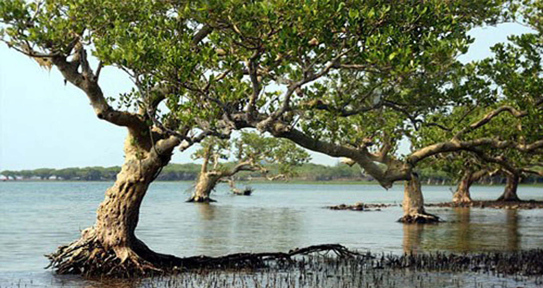
A group of mature mangrove trees with visible gnarled trunks and roots growing directly out of shallow water in a coastal wetland.
Mangrove trees growing in the waters of the Dongzhai Harbour reserve.

Dongzhaigang National Nature Reserve history and protected-area timeline

Dongzhaigang National Nature Reserve was officially established in 1986, at a time when mangrove conservation was still emerging as a formal priority in China. Its creation is recognized as the first instance in the country of a nature reserve dedicated specifically to the protection of mangrove wetlands, paving the way for later mangrove-focused protections elsewhere along China's southern coast.

In the years following its establishment, the reserve gained broader international recognition through its inclusion in the international list of important wetlands, which acknowledged Dongzhaigang as part of the first cohort of Chinese sites to receive that designation. It has also been placed on the tentative list for UNESCO World Heritage status, reflecting sustained recognition of the reserve's global ecological importance.

The broader landscape that the reserve protects was shaped by a major seismic event roughly four centuries ago, which caused land subsidence along this stretch of coast and produced the irregular, indented bay that defines the site today. While this geological history is ancient, it set the stage for the development of the tidal flats and mangrove habitat that later warranted formal protection.

Dongzhaigang National Nature Reserve landscape and geographic character

The landscape of Dongzhaigang is defined by a broad, funnel-shaped coastal bay on the northern edge of Hainan Island. The bay's irregular outline traces back to historical tectonic activity and seismic subsidence, which lowered sections of the coastline and left behind a deeply indented shoreline. Today this produces an exceptionally varied coastal geography, with numerous small bays, inlets, and tidal creeks cutting into the surrounding land.

Within the bay, the terrain is dominated by gently sloping intertidal mudflats and a network of meandering tidal channels. The flats are wide and relatively flat, allowing tides to spread across large areas twice a day. Mangrove forest is concentrated along the southern coast of the bay, where brackish conditions and sheltered shorelines support dense stands. Six rivers empty into the bay, adding freshwater inputs that influence salinity patterns along the shore.

The tidal environment is highly dynamic. The reserve experiences an irregular semidiurnal tidal pattern, with marked differences between high and low water levels. This produces a broad intertidal zone that is alternately submerged and exposed, with muddy, organic-rich sediments that form the foundation of the mangrove ecosystem. Erosion-resistant mangrove roots further shape the shoreline, building up sediment and stabilizing the coast.

Dongzhaigang National Nature Reserve ecosystems, habitats, and plant life

Dongzhaigang's ecological character is built around its mangrove-dominated wetland system, set within a tropical monsoon maritime climate. Temperatures are consistently warm, rainfall is high, and humidity remains elevated throughout the year, creating ideal growing conditions for mangrove species and the broader coastal ecosystem they support.

The mangrove forests form the core habitat of the reserve. They grow along sheltered, brackish portions of the shore, especially on the southern coast of the bay, where freshwater from inflowing rivers mixes with seawater. The mix of salinity levels, combined with sheltered tidal flats and nutrient-rich mud, supports structurally diverse mangrove vegetation with extensive root systems that extend both above and below the intertidal zone.

Surrounding the mangroves, the reserve includes extensive tidal flats and shallow marine areas that expand and contract with the tides. These flats are ecologically rich, hosting crabs, shellfish, and other invertebrates that thrive in the muddy substrate. The channels threading through the flats serve as conduits for nutrients, sediments, and small marine organisms, linking the mangrove fringe to the deeper waters of the bay. The result is a layered ecosystem spanning true marine, intertidal, brackish, and freshwater-influenced environments.

Dongzhaigang National Nature Reserve wildlife and species highlights

Wildlife at Dongzhaigang reflects the productivity of the mangrove and intertidal environment. The reserve is an important refuge and stopover site for birds, with the southern coastal mangroves providing nesting, roosting, and feeding habitat for a wide range of species. The combination of dense mangrove cover, open mudflats, and tidal waters creates conditions suitable for both resident and migratory waterbirds.

The intertidal flats and mangrove root systems support rich invertebrate communities, especially crabs and other benthic animals adapted to brackish, oxygen-poor, muddy conditions. These invertebrates in turn sustain fish and bird populations, creating a productive food web within the reserve. The brackish coastal waters and the inflowing rivers also serve as nursery habitats for a variety of coastal fish species, linking the reserve's ecological role to the broader marine environment offshore.

Although the reserve is primarily recognized for its mangrove and wetland fauna, the surrounding habitats also host reptiles and other groups typical of tropical Hainan coastal ecosystems. The overall wildlife profile is characteristic of a functioning mangrove ecosystem, with high productivity at the base of the food chain supporting a diverse community above.

Dongzhaigang National Nature Reserve conservation status and protection priorities

Dongzhaigang holds a distinctive place in China's conservation framework as the country's first nature reserve dedicated specifically to mangrove wetland protection. Its establishment in 1986 helped set the template for mangrove-focused conservation along China's tropical and subtropical coasts, and it continues to be treated as a reference site for mangrove protection strategy.

The reserve's ecological importance has been formally acknowledged beyond China. It was among the first group of Chinese wetlands added to the international list of important wetlands, an early recognition that highlighted the global value of its mangrove and tidal flat habitats. It has also been placed on UNESCO's tentative list for World Heritage designation, reflecting sustained international interest in the site's ecological significance.

Beyond formal recognition, the reserve's value lies in the ecological functions its mangrove ecosystem performs. Mangroves stabilize sediments, reduce coastal erosion, buffer storm surges, and filter nutrients carried by inland rivers. The reserve's tidal flats and mangroves also function as critical habitat for migratory birds and as nursery grounds for coastal fish. By protecting a large, structurally complex mangrove wetland in a tropical coastal setting, Dongzhaigang contributes to broader goals of shoreline resilience, biodiversity protection, and wetland conservation in southern China.

Dongzhaigang National Nature Reserve cultural meaning and human context

Dongzhaigang sits within Haikou City's Meilan District, on the northern coast of Hainan Island, an area where traditional coastal and fishing communities have long been linked to the marine and estuarine environment of the bay. The mangrove-lined shores have historically supported local livelihoods through fishing, shellfish gathering, and small-scale use of estuary resources, embedding the protected landscape in the everyday geography of northern Hainan.

The reserve's proximity to Haikou, the provincial capital, also gives it a cultural role beyond traditional coastal life. It represents a place where the region's tropical maritime identity intersects with modern environmental awareness, contributing to growing public familiarity with mangrove ecosystems as both ecological treasures and part of Hainan's coastal heritage.

Top sights and standout views in Dongzhaigang National Nature Reserve

Notable features of Dongzhaigang National Nature Reserve include its status as China's first dedicated mangrove nature reserve, its inclusion among the first Chinese sites formally recognized in the international wetland list, and its place on UNESCO's tentative list for World Heritage status. The reserve's funnel-shaped bay, earthquake-shaped coastline, and extensive tidal channel network give it unusual physical complexity for a mangrove site.

Its mangrove forests, broad intertidal flats, and brackish river-influenced waters create a layered ecosystem that supports diverse birdlife, invertebrates, and juvenile fish, anchoring the reserve's importance for both regional biodiversity and coastal resilience on Hainan's northern shore.

Best time to visit Dongzhaigang National Nature Reserve

Dongzhaigang sits in a tropical monsoon maritime climate, so conditions remain warm and humid throughout the year. Wildlife viewing, particularly for migratory and waterbirds, often aligns with seasonal migration patterns along the East Asian coast, when the bay's intertidal flats and mangroves host the highest concentrations of visiting species. Cooler, drier stretches of the year typically offer more comfortable conditions for exploring the reserve, while warmer, rainier periods emphasize the lush character of the mangrove ecosystem and active tidal cycles in the bay.

Monthly climate preview

Long-term monthly temperature and precipitation patterns sampled from representative coordinate data.

海南东寨港国家级自然保护区 Climate Normals and Annual Temperature Rhythm

Representative coordinate records for 海南东寨港国家级自然保护区 outline a measured annual cycle of changing monthly temperatures and precipitation rates from 1991 to 2020. Examining the complete twelve-month climatology dataset clarifies multi-season averages across the protected area coordinate.
Annual mean25 °C
19 °C28 °C
Jan19°
Feb20°
Mar23°
Apr25°
May27°
Jun28°
Jul28°
Aug28°
Sep28°
Oct26°
Nov23°
Dec20°
Warmest month
June

28.3 °C

Coolest month
January

18.9 °C

Wettest month
August

9 mm/day

Driest month
January

0.9 mm/day

Park location guide

Geography guide, regional context, and park location map for Dongzhaigang National Nature Reserve

Dongzhaigang National Nature Reserve park geography, regions, and map view in China

Understand where Dongzhaigang National Nature Reserve sits in China through a broader geographic reading of the surrounding landscape, nearby location context, and its mapped position within the national park landscape.

How Dongzhaigang National Nature Reserve fits into China

China is a unitary communist state in East Asia, governed by the Chinese Communist Party. The country's capital is Beijing, while Shanghai is the largest city by urban population. China has 33 province-level divisions including provinces, autonomous regions, municipalities, and special administrative regions. The nation has a long history spanning thousands of years, with achievements including the invention of gunpowder, paper, printing, and the compass.

Wider geography shaping Dongzhaigang National Nature Reserve in China

China is located in East Asia, bordering fourteen countries: Russia, North Korea, Vietnam, Laos, Myanmar, India, Bhutan, Nepal, Pakistan, Afghanistan, Tajikistan, Kyrgyzstan, Kazakhstan, and Mongolia. The country spans diverse terrain including deserts, mountains, plateaus, and river valleys. Major river systems include the Yellow River and Yangtze River. The coastline stretches along the East China Sea, South China Sea, and Yellow Sea.

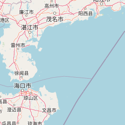
Map view of Dongzhaigang National Nature Reserve

Use this park location map to pinpoint Dongzhaigang National Nature Reserve in China, understand its exact geographic position, and read its mapped placement within the surrounding landscape more clearly.

Pigeon | © OpenStreetMap contributors

Location context for Dongzhaigang National Nature Reserve

Hainan

Explore detailed visual documentation of intertidal mudflats, dense mangrove forests, and coastal wetlands.

海南东寨港国家级自然保护区 Landscape Photos and Scenery: Visualizing China's Pioneer Mangrove Reserve

Visual documentation captures the complex coastal geography and dynamic tidal channels that define the protected mangrove ecosystem of 海南东寨港国家级自然保护区. Photographic records provide clear insight into intertidal habitats and shoreline terrain across tropical northern Hainan.

A group of mature mangrove trees with visible gnarled trunks and roots growing directly out of shallow water in a coastal wetland.

Park atlas

Compare surrounding regional geography and connected coastal wetland reserves

Parks Near 海南东寨港国家级自然保护区 and Related Protected Landscapes

Browsing other protected areas near 海南东寨港国家级自然保护区 reveals broader regional conservation patterns and coastal wetland geography. Comparing adjacent habitats allows researchers and visitors to examine diverse tropical marine ecosystems and estuarine terrain across the surrounding region.
Nature reserveGuangxi
About 184 km away#1 closest

Northwest

Guangxi Hepu Dugong National Nature Reserve: Coastal Geography and Marine Protected Area

Protected marine landscape in the Gulf of Tonkin, China.

Gain insights into the geographic extent and marine environment of Guangxi Hepu Dugong National Nature Reserve. This protected area in the Beibu Gulf anchors regional conservation efforts through its distinct seagrass beds, tidal flats, and extensive shallow-water habitats that support rare marine life.

Area
350 km²
Established
1992
Relief
Lowland
Climate
Subtropical
Watercolor painting showing a coastal landscape with distant islands, green vegetation, and a horizon line
National parkQuảng Ninh Province
About 331 km away#2 closest

West

Bái Tử Long National Park: Protected Island Archipelago and Marine Landscape Discovery

Explore the geography and mapped protected boundaries.

Bái Tử Long National Park, located in Vietnam's Quảng Ninh Province, is a protected national park distinguished by its archipelago of approximately 40 limestone islands and significant marine environments. As one of Vietnam's few national parks designated to protect both land and sea, it provides critical atlas-level insights into coastal karst topography, marine biodiversity, and the interconnectedness of island ecosystems. Discover the park's unique geographic features and its role as a vital protected landscape within the broader regional context.

Area
157.83 km²
Established
2001
IUCN
II
Relief
Mixed relief
National parkVietnam
About 365 km away#3 closest

West

Cát Bà National Park: Vietnam's Critically Endangered Species Sanctuary & Karst Landscape

Mapped protected area with diverse terrestrial and marine ecosystems.

As a critical national park in Vietnam, Cát Bà National Park protects a remarkable limestone karst landscape central to the Hạ Long Bay region. This area is renowned for its steep peaks, narrow valleys, and coastal mangrove environments, supporting a uniquely diverse array of flora and fauna. Its status as a protected area highlights its global importance for conservation, particularly as the exclusive habitat of the Cát Bà langur. Explore the mapped geography and ecological significance of this vital Vietnamese protected land.

Area
161.968 km²
Established
1986
IUCN
II
Relief
Highland
Watercolor illustration of a wetland landscape with green trees and a pale sky
National parkNam Định Province
About 425 km away#4 closest

West

Xuân Thủy National Park: Protected Landscape Identity and Mapped Geography in Nam Định

Explore the national park's protected boundaries and regional landscape.

Xuân Thủy National Park serves as a vital protected landscape within Nam Định Province, Vietnam, offering users a clear point of entry for understanding its geographic identity. This page facilitates detailed exploration of its mapped park boundaries and the surrounding natural terrain, providing essential context for anyone interested in the regional geography of protected areas. Discover the specific landscape characteristics that define this national park and its place within Vietnam's conservation network.

Area
7,100 km²
Established
2003
IUCN
II
Relief
Lowland
National parkVietnam
About 501 km away#5 closest

Southwest

Bach Ma National Park: Protected Area and Mountain Landscape in Vietnam

Explore the biodiversity and unique geography of this vital national park.

Bach Ma National Park in Vietnam is a protected area defined by its steep, granite-rich mountainous terrain within the Annamite Range. The park’s location at a significant biogeographical crossroads contributes to its exceptional biodiversity, particularly its documented birdlife and varied forest ecosystems. Understanding Bach Ma National Park through its mapped landscape provides critical insight into Vietnam's natural heritage and the ecological dynamics shaped by its unique regional geography.

Area
220 km²
Established
1986
IUCN
II
Relief
Mountain
National parkNinh Bình Province
About 521 km away#6 closest

West

Cúc Phương National Park: National Park Atlas and Mapped Protected Landscape Details

Explore its geographic setting and protected area boundaries.

Gain structured insight into Cúc Phương National Park, a designated national park in Vietnam situated within Ninh Bình Province. This entry provides detailed geographic context, focusing on the park's mapped boundaries and its identity as a protected landscape. It is designed to support atlas-driven exploration and understanding of Vietnam's natural geography.

Established
1962
Relief
Mountain
Climate
Tropical
Access
Moderate access
Watercolor illustration of a river flowing through a valley with green forests and distant mountains
National parkVietnam
About 522 km away#7 closest

Southwest

Phong Nha, Kẻ Bàng National Park: Vietnam's Karst Terrain and Subterranean World

Explore protected landscapes, cave systems, and geological wonders.

Phong Nha, Kẻ Bàng National Park in Vietnam is a globally significant protected landscape, recognized by UNESCO for its exceptional karst topography and extensive cave networks. This national park features dramatic limestone mountains, deep river gorges, and some of the world's most impressive subterranean formations, offering a rich atlas of natural history and geological wonders to explore.

Area
857.54 km²
Established
2001
IUCN
II
Visitors
740K annual
National parkThanh Hóa Province
About 528 km away#8 closest

West

Ben En National Park: Vietnam National Park Geography and Mapped Landscape Context

Explore protected area boundaries and regional terrain.

Ben En National Park represents a key protected natural area within Thanh Hóa Province, Vietnam. This detail page facilitates a structured discovery of its geographic features, mapped extent, and its significance as a national park. Dive into the atlas context to understand the park's landscape and its regional setting, offering a factual foundation for geographic exploration.

Area
147.35 km²
Established
1992
IUCN
II
Visitors
6.6K annual

Common questions about visiting, size, designation, and location context for Dongzhaigang National Nature Reserve

Dongzhaigang National Nature Reserve FAQs for park facts, access, geography, and protected area context

Find quick answers about Dongzhaigang National Nature Reserve, including protected-area facts, park geography, trail and visitor context, and how the park fits into its surrounding country and regional landscape.
MoriAtlas Explorer

Continue Your Protected Areas Search Across the Global Atlas

Deepen your exploration by continuing the structured search for national parks and protected areas worldwide. Utilize the comprehensive filtering capabilities to compare different conservation landscapes and refine your understanding of global park geography. Discover more about the distribution and characteristics of protected natural areas.

Global natural geography