Mori Atlas logo
Nature reserveGuangxi Hepu Dugong National Nature Reserve

Understanding the ecological boundaries, seagrass meadows, and marine terrain of China's primary dugong habitat.

Guangxi Hepu Dugong National Nature Reserve: Protected Marine Landscapes and Coastal Geography

Guangxi Hepu Dugong National Nature Reserve protects a vital marine mosaic along the southeastern coast of Hepu County within the Gulf of Tonkin. This coastal territory encompasses expansive seagrass meadows, intertidal flats, and submerged seabed plains that serve as a cornerstone for marine biodiversity in southern China. The reserve preserves a delicate interaction between tidal channels and shallow waters, offering a clear geographic view of one of the most significant marine protected areas in the region.

marine protected areadugong conservationseagrass meadowsintertidal flatscoastal reserveGulf of Tonkin

Guangxi Hepu Dugong National Nature Reserve

Nature reserve

Park overview

Structured park overview, official facts, and landscape profile for Guangxi Hepu Dugong National Nature Reserve

Guangxi Hepu Dugong National Nature Reserve park facts, protected area profile, and essential visitor context

Review the core facts for Guangxi Hepu Dugong National Nature Reserve, including designation, size, terrain, visitor scale, habitats, and operating context in one park-focused overview.

About Guangxi Hepu Dugong National Nature Reserve

The Guangxi Hepu Dugong National Nature Reserve is a coastal and shallow marine protected area in the Beibu Gulf, in the northeastern section of the Gulf of Tonkin. It is administered in the context of Guangxi's broader network of nature reserves and sits within the coastal jurisdiction of Hepu County in Beihai City. The protected waters span from Yingluo Harbor near Shankou Town in the east to the area around Shatian Town in the west, encompassing a stretch of shoreline that forms a continuous zone of marine and intertidal habitats.

The reserve's defining identity is rooted in its dual ecological and institutional character. Ecologically, it protects an unusually rich mosaic of coastal marine environments, including seagrass meadows, intertidal shallow flats, tidal channels, tidal sand ridges, and seabed plains. These habitats support a community of marine life whose most prominent member is the dugong. Institutionally, the reserve represents China's focused national effort to protect a marine mammal that, in Chinese waters, survives only in small and highly vulnerable populations along the southern coast.

The protected area is also recognized for its broader marine biodiversity role. Beyond the dugong, the reserve's waters are an important habitat for the Indo-Pacific humpback dolphin, and they intersect with the ranges of other rare marine species such as Bryde's whales, blue whales, finless porpoises, whale sharks, and sea turtles. The reserve's mandate therefore extends beyond a single species to encompass the conservation of an interconnected coastal marine ecosystem in which seagrass habitats, marine mammals, and broader marine biodiversity are managed as a single integrated system.

Quick facts and research context for Guangxi Hepu Dugong National Nature Reserve

The Guangxi Hepu Dugong National Nature Reserve is a national-level marine reserve situated in the coastal waters of Hepu County, Beihai, in the Guangxi Zhuang Autonomous Region of southern China. It occupies a position in the northeastern Gulf of Tonkin and covers an area commonly cited as roughly 35,000 hectares. The reserve was first designated as an autonomous region-level protected area in 1986 and upgraded to national status in 1992, making it the only national nature reserve in China whose core mandate is dugong conservation.

The protected area is characterized by shallow coastal waters, intertidal flats, tidal channels, tidal sand ridges, and seabed plains. Seagrass meadows, dominated by species such as Halophila ovalis, form the foundational habitat for dugong feeding. The reserve also functions as a site for the protection of associated rare marine fauna, most notably the Indo-Pacific humpback dolphin, and serves as a platform for marine research, monitoring, and public outreach.

Protection and recognition

Marine protected area management scope and documented international recognition records

Guangxi Hepu Dugong National Nature Reserve Protection Status and Governance Data

Marine conservation metrics and designation details outline the documented protection status for Guangxi Hepu Dugong National Nature Reserve. Official records compile administrative frameworks and international recognition sources to support park geography analysis.

Protection details

Protection scope
Marine
Transboundary protection
No
Core area
132 km²
Buffer area
108 km²
Park context

Deeper park guide and search-rich context for Guangxi Hepu Dugong National Nature Reserve

Guangxi Hepu Dugong National Nature Reserve history, landscape, wildlife, and travel context

Explore Guangxi Hepu Dugong National Nature Reserve through its history, landscape character, ecosystems, wildlife, conservation priorities, cultural context, and seasonal travel timing in a structured park guide built for atlas discovery and search intent.

Why Guangxi Hepu Dugong National Nature Reserve stands out

The reserve is best known as China's only national nature reserve established specifically to protect the dugong and the seagrass habitats on which dugongs depend for survival. Dugongs are the defining species of the protected area, and the reserve's existence reflects a national recognition that the shallow, seagrass-rich waters of the northeastern Gulf of Tonkin constitute one of the most important remaining strongholds for this marine mammal in Chinese waters. Equally important is the ecological setting that supports the dugong: an extensive mosaic of seagrass beds, intertidal flats, tidal channels, tidal sand ridges, and shallow seabed plains. These habitats give the reserve its broader identity as a marine ecological conservation site, where the protection of seagrass habitats is inseparable from the protection of a flagship species that has become a symbol of marine biodiversity conservation in southern China.

Guangxi Hepu Dugong National Nature Reserve history and protected-area timeline

The reserve's history begins in 1986, when the Guangxi Zhuang Autonomous Region People's Government approved the establishment of an autonomous region-level dugong nature reserve in the coastal waters of Hepu County. This original designation reflected growing awareness of the ecological importance of the local seagrass meadows and the vulnerability of dugong populations in Chinese waters.

In 1992, the reserve was elevated to national status, transforming it from a regional protected area into a national nature reserve with national recognition and a national conservation mandate. This upgrade aligned the reserve with China's broader national nature reserve system and underscored the significance of the Hepu coastal waters as one of the most important dugong habitats in the country.

In 1996, the Guangxi Hepu Dugong National Nature Reserve Management Station was formally established to administer the site. The management station, operating under the environmental authorities of Guangxi, developed into the institutional core of the reserve, organizing protection work, monitoring, and public outreach, and later establishing a satellite presence in Shatian Town to better cover the western portion of the protected waters.

Guangxi Hepu Dugong National Nature Reserve landscape and geographic character

The reserve's landscape is entirely marine and coastal. It lies within the shallow coastal waters of the northeastern Gulf of Tonkin, where the seafloor and shoreline form an interconnected mosaic of distinct physical environments. Intertidal shallow flats emerge and submerge with the tide, while tidal channels, tidal sand ridges, and broader seabed plains extend below the surface as defining features of the seafloor topography.

The shoreline itself stretches continuously along the coast from the eastern edge near Yingluo Harbor to the western portions near Shatian Town. This configuration gives the reserve a long, linear geometry shaped by the curvature of Hepu County's coast, rather than the compact shape typical of inland reserves. The total length of the reserve's coastline is on the order of several tens of kilometers, framing a broad band of coastal and shallow-marine habitats that interact strongly with tides, currents, and seasonal sediment movement.

The broader regional context is that of a tropical to subtropical marine environment with a marine monsoon climate, shallow productive waters, and a coastline shaped by long-term interaction between land runoff, tidal action, and offshore deposition. This combination produces the productive seafloor conditions that have historically allowed dense seagrass beds to develop, and that continue to determine the ecological character of today's reserve.

Guangxi Hepu Dugong National Nature Reserve ecosystems, habitats, and plant life

Ecologically, the reserve is defined by its seagrass meadows and the marine habitats that frame them. The seagrass beds form the ecological backbone of the protected area, providing the principal feeding habitat for dugongs and structuring a wide range of associated ecological processes, from nutrient cycling to shelter for small marine organisms.

The seagrass community is composed of several recognizable species, with Halophila ovalis described in the regional literature as a dominant or characteristic species. Other recorded species include Zostera japonica, Halophila beccarii, and Halodule uninervis, together producing a diverse seagrass assemblage for a tropical to subtropical coastal setting. These seagrasses grow on soft sediments in shallow water, forming beds that collectively extend across a substantial portion of the reserve's seafloor.

Surrounding the seagrass meadows are intertidal flats, tidal channels, tidal sand ridges, and seabed plains. Together, these habitats create a gradient of marine environments, from the amphibious intertidal zone to the permanently submerged seabed. The combination of feeding habitats, shelter, and varied seafloor topography gives the reserve a layered ecological structure, and makes it possible for both resident and transient marine species to occupy different niches within the same protected area.

Guangxi Hepu Dugong National Nature Reserve wildlife and species highlights

Wildlife is the central reason for which the reserve exists. Dugongs are the flagship species and the primary focus of all conservation activity within the protected area. Dugongs are herbivorous marine mammals that depend directly on seagrass meadows for food, and the reserve's seagrass habitats are therefore not only an ecological feature but also the literal foundation for the survival of the local dugong population.

The reserve also explicitly protects the Indo-Pacific humpback dolphin. The same waters host an assemblage of other rare marine animals whose range overlaps with the reserve, including Bryde's whales, blue whales, and finless porpoises among the marine mammals, and whale sharks and sea turtles among the larger non-mammalian marine wildlife. While the reserve's institutional mandate is centered on dugongs, its ecological reality is that of a multi-species marine conservation landscape in which several vulnerable species share the same productive coastal waters.

The current conservation situation for many of these species is fragile. The dugong population in the reserve is small, and pressures on seagrass habitats have clear downstream effects on its long-term viability. The presence of other rare marine species in the same waters heightens the conservation stakes of the reserve and reinforces its importance as a refugium for marine biodiversity in the northern Gulf of Tonkin.

Guangxi Hepu Dugong National Nature Reserve conservation status and protection priorities

The reserve is a national-level conservation instrument operating under the umbrella of China's national nature reserve system. Its creation in 1986 and elevation to national status in 1992 reflect an explicit national decision to protect one of the country's most important remaining dugong habitats. The reserve's conservation mandate is built around the dugong and the seagrass meadows on which it depends, but it extends in practice to other rare marine species that share the same coastal waters, notably the Indo-Pacific humpback dolphin.

The conservation rationale for the reserve is twofold. First, it secures a recognized, legally protected zone in which seagrass habitats and the marine fauna tied to them can survive in the face of intense regional pressure from coastal development, fisheries, and pollution. Second, it provides an institutional framework for research, monitoring, public outreach, and the enforcement of protective regulations in an area where economic and ecological interests are in direct tension.

The reserve's conservation challenges are significant. The surrounding coastal region has seen rapid expansion of marine aquaculture, especially shellfish farming, which has contributed to habitat degradation, seagrass dieback, and pollution. Fast-moving fishing vessels and dense fishing nets continue to pose serious risks to dugongs and other marine animals. The reserve's management authorities have explicitly identified the conflict between economic development and environmental protection, and the shortage of funding, as the central obstacles to long-term dugong conservation in the area.

Guangxi Hepu Dugong National Nature Reserve cultural meaning and human context

Although the reserve is primarily a marine ecological site rather than a cultural or historical site, the coastal zone in which it sits carries an ancient heritage of human maritime activity. Hepu County has historically been one of the most important maritime gateways of southern China, and the coastal communities around the reserve, including those in Shankou and Shatian, have long traditions of fishing and small-scale marine resource use.

This long-standing human presence along the coast is precisely what makes the conservation message of the reserve so complex. The local economy, the traditional livelihoods of coastal villages, and the development of intensive aquaculture have all shaped the environmental pressures facing the reserve. Dugong conservation in Hepu is therefore not only a marine ecological question but also a question of reconciling modern economic development with traditional coastal ways of life.

Top sights and standout views in Guangxi Hepu Dugong National Nature Reserve

China's only national nature reserve explicitly created for the dugong, and one of the most important sites in Chinese waters for the long-term survival of this species. The reserve combines extensive seagrass meadows with a varied mosaic of shallow marine and intertidal habitats that collectively support both dugongs and other rare marine species, most notably the Indo-Pacific humpback dolphin.

The reserve's institutional story, from regional designation in 1986 to national status in 1992 and the establishment of a dedicated management station in 1996, marks it as a landmark effort in the development of China's marine protected area system. At the same time, its current conservation challenges, especially the pressures from coastal aquaculture, marine traffic, and limited funding, make it an important case study in the real-world tensions between marine biodiversity protection and rapid coastal economic growth.

Best time to visit Guangxi Hepu Dugong National Nature Reserve

The reserve lies in a region with a southern subtropical marine monsoon climate and warm temperatures year-round. Conditions for a coastal visit are broadly favorable across multiple seasons, with the cooler and drier months often offering calmer atmospheric conditions and clearer views over the typical tropical maritime haze of the warmer, more humid season. Wildlife-focused visits may benefit from periods when offshore visibility for marine mammal observation is typically higher.

Given the reserve's focus on marine and seagrass ecosystems rather than terrestrial landscapes, the seasonal character of a visit is shaped less by dramatic scenery changes than by sea conditions, visibility, and the activity patterns of marine mammals. A visit oriented toward understanding the seagrass meadows and the broader coastal ecosystem can be rewarding across much of the year, while observers hoping to spot dugongs or Indo-Pacific humpback dolphins should plan around typical periods of higher offshore visibility and calmer sea conditions.
Monthly climate preview

Long term temperature ranges and monthly precipitation distributions across the protected coastal reserve

Annual Climate Normals and Weather Patterns at Guangxi Hepu Dugong National Nature Reserve

Representative coordinates record measured average monthly temperatures spanning from sixteen to twenty nine degrees alongside shifting precipitation volumes across the year. Reviewing the complete twelve month profile provides deeper insight into long term climatological variations at the protected site.
Annual mean24 °C
16 °C29 °C
Jan16°
Feb18°
Mar21°
Apr25°
May28°
Jun29°
Jul29°
Aug29°
Sep28°
Oct25°
Nov22°
Dec17°
Warmest month
July

28.9 °C

Coolest month
January

16.4 °C

Wettest month
August

10.9 mm/day

Driest month
December

1 mm/day

Park location guide

Geography guide, regional context, and park location map for Guangxi Hepu Dugong National Nature Reserve

Guangxi Hepu Dugong National Nature Reserve park geography, regions, and map view in China

Understand where Guangxi Hepu Dugong National Nature Reserve sits in China through a broader geographic reading of the surrounding landscape, nearby location context, and its mapped position within the national park landscape.

How Guangxi Hepu Dugong National Nature Reserve fits into China

China is a unitary communist state in East Asia, governed by the Chinese Communist Party. The country's capital is Beijing, while Shanghai is the largest city by urban population. China has 33 province-level divisions including provinces, autonomous regions, municipalities, and special administrative regions. The nation has a long history spanning thousands of years, with achievements including the invention of gunpowder, paper, printing, and the compass.

Wider geography shaping Guangxi Hepu Dugong National Nature Reserve in China

China is located in East Asia, bordering fourteen countries: Russia, North Korea, Vietnam, Laos, Myanmar, India, Bhutan, Nepal, Pakistan, Afghanistan, Tajikistan, Kyrgyzstan, Kazakhstan, and Mongolia. The country spans diverse terrain including deserts, mountains, plateaus, and river valleys. Major river systems include the Yellow River and Yangtze River. The coastline stretches along the East China Sea, South China Sea, and Yellow Sea.

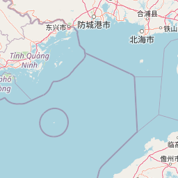
Map view of Guangxi Hepu Dugong National Nature Reserve

Use this park location map to pinpoint Guangxi Hepu Dugong National Nature Reserve in China, understand its exact geographic position, and read its mapped placement within the surrounding landscape more clearly.

Pigeon | © OpenStreetMap contributors

Location context for Guangxi Hepu Dugong National Nature Reserve

Guangxi
Park atlas

Compare nearby marine reserves and coastal habitats across the surrounding regional geography

Explore Protected Areas and Parks Near Guangxi Hepu Dugong National Nature Reserve

Browse other protected areas and coastal reserves situated close to Guangxi Hepu Dugong National Nature Reserve. Comparing adjacent marine habitats provides deeper geographic context for regional biodiversity conservation.
Watercolor painting of a tranquil wetland landscape featuring a winding river, green shoreline vegetation, and soft, rolling hills in the background against a white backdrop.
Nature reserveHainan
About 184 km away#1 closest

Southeast

海南东寨港国家级自然保护区: Geographic Profile and Mangrove Wetland Boundaries

Coastal wetland landscapes on the northern edge of Hainan

Understand the physical landscape of 海南东寨港国家级自然保护区 through its complex tidal networks and brackish estuaries. This nature reserve provides essential insights into mangrove forest stability, sediment accumulation, and coastal resilience within the broader geography of Hainan province.

Area
33.376 km²
Established
1986
IUCN
V
Relief
Lowland
Watercolor painting showing a coastal landscape with distant islands, green vegetation, and a horizon line
National parkQuảng Ninh Province
About 211 km away#2 closest

West

Bái Tử Long National Park: Protected Island Archipelago and Marine Landscape Discovery

Explore the geography and mapped protected boundaries.

Bái Tử Long National Park, located in Vietnam's Quảng Ninh Province, is a protected national park distinguished by its archipelago of approximately 40 limestone islands and significant marine environments. As one of Vietnam's few national parks designated to protect both land and sea, it provides critical atlas-level insights into coastal karst topography, marine biodiversity, and the interconnectedness of island ecosystems. Discover the park's unique geographic features and its role as a vital protected landscape within the broader regional context.

Area
157.83 km²
Established
2001
IUCN
II
Relief
Mixed relief
National parkVietnam
About 268 km away#3 closest

West

Cát Bà National Park: Vietnam's Critically Endangered Species Sanctuary & Karst Landscape

Mapped protected area with diverse terrestrial and marine ecosystems.

As a critical national park in Vietnam, Cát Bà National Park protects a remarkable limestone karst landscape central to the Hạ Long Bay region. This area is renowned for its steep peaks, narrow valleys, and coastal mangrove environments, supporting a uniquely diverse array of flora and fauna. Its status as a protected area highlights its global importance for conservation, particularly as the exclusive habitat of the Cát Bà langur. Explore the mapped geography and ecological significance of this vital Vietnamese protected land.

Area
161.968 km²
Established
1986
IUCN
II
Relief
Highland
Watercolor illustration of a wetland landscape with green trees and a pale sky
National parkNam Định Province
About 350 km away#4 closest

West

Xuân Thủy National Park: Protected Landscape Identity and Mapped Geography in Nam Định

Explore the national park's protected boundaries and regional landscape.

Xuân Thủy National Park serves as a vital protected landscape within Nam Định Province, Vietnam, offering users a clear point of entry for understanding its geographic identity. This page facilitates detailed exploration of its mapped park boundaries and the surrounding natural terrain, providing essential context for anyone interested in the regional geography of protected areas. Discover the specific landscape characteristics that define this national park and its place within Vietnam's conservation network.

Area
7,100 km²
Established
2003
IUCN
II
Relief
Lowland
National parkVĩnh Phúc Province
About 406 km away#5 closest

West

Tam Dao National Park: Vietnam's Mountain National Park and Biodiversity Hotspot

Explore mapped boundaries and regional landscape context.

Tam Dao National Park is a key protected area in northern Vietnam, defined by its rugged mountain terrain featuring over 20 peaks exceeding 1,000 meters. This national park is a vital habitat for diverse flora and fauna, including numerous endemic species, and showcases transitional forest ecosystems from tropical to montane zones. Understanding Tam Dao National Park involves exploring its geographic setting within Vĩnh Phúc Province and appreciating its role as a significant protected landscape.

Area
368.83 km²
Established
1996
IUCN
II
Relief
Mountain
Watercolor painting depicting a lake with green hills and vegetation
National parkBắc Kạn Province
About 422 km away#6 closest

West

Ba Bể National Park: Vietnam's Largest Freshwater Karst Lake and Protected Landscape

Discover the mapped geography of this unique protected wetland in Bắc Kạn.

Ba Bể National Park is distinguished by Vietnam's largest natural freshwater lake, a perennial karst water body set within a dramatic limestone landscape. This national park in Bắc Kạn Province protects a vital wetland ecosystem and its surrounding highland forests, offering a rich geographic context for atlas exploration. Explore the park's unique terrain, mapped boundaries, and the remarkable biodiversity it preserves, making it a cornerstone of regional natural landscape discovery.

Area
100.48 km²
Established
1992
IUCN
II
Relief
Mixed relief
National parkNinh Bình Province
About 437 km away#7 closest

West

Cúc Phương National Park: National Park Atlas and Mapped Protected Landscape Details

Explore its geographic setting and protected area boundaries.

Gain structured insight into Cúc Phương National Park, a designated national park in Vietnam situated within Ninh Bình Province. This entry provides detailed geographic context, focusing on the park's mapped boundaries and its identity as a protected landscape. It is designed to support atlas-driven exploration and understanding of Vietnam's natural geography.

Established
1962
Relief
Mountain
Climate
Tropical
Access
Moderate access
National parkHanoi
About 446 km away#8 closest

West

Ba Vì National Park: Ancient Volcanic Mountains and Protected Landscape Near Hanoi

Discover the mapped geography and biodiversity of this national park.

Ba Vì National Park, a protected natural area near Hanoi, showcases a dramatic landscape shaped by ancient volcanic activity. The park features three significant peaks, including Vua Mountain, creating a distinct topographical profile. Spanning over 10,800 hectares, it is recognized for its ecological diversity, harboring a wealth of plant and animal species. This national park serves as a vital protected landscape, offering a unique opportunity for geographic exploration and understanding the natural terrain surrounding the Vietnamese capital.

Area
108.15 km²
Established
1991
IUCN
II
Relief
Mountain

Common questions about visiting, size, designation, and location context for Guangxi Hepu Dugong National Nature Reserve

Guangxi Hepu Dugong National Nature Reserve FAQs for park facts, access, geography, and protected area context

Find quick answers about Guangxi Hepu Dugong National Nature Reserve, including protected-area facts, park geography, trail and visitor context, and how the park fits into its surrounding country and regional landscape.
MoriAtlas Explorer

Continue Your Protected Areas Search Across the Global Atlas

Deepen your exploration by continuing the structured search for national parks and protected areas worldwide. Utilize the comprehensive filtering capabilities to compare different conservation landscapes and refine your understanding of global park geography. Discover more about the distribution and characteristics of protected natural areas.

Global natural geography