Mori Atlas logo
Nature reserveHawf National Reserve

Explore the mapped geography and protected boundaries of this vital nature reserve.

Hawf National Reserve: Nature Reserve Mapping and Protected Landscape in Yemen

Hawf National Reserve represents a significant protected area within Yemen, situated on the Arabian Peninsula. As a designated nature reserve, its geographic boundaries and landscape context are central to understanding conservation efforts in the region. This page offers a detailed atlas-style view, focusing on the mapped terrain and the role Hawf National Reserve plays as a protected landscape within Yemen's diverse geography.

national reserveYemenArabian Peninsulaprotected areaMiddle Eastnature conservation

Hawf National Reserve

Nature reserve

Park overview

Structured park overview, official facts, and landscape profile for Hawf National Reserve

Hawf National Reserve park facts, protected area profile, and essential visitor context

Review the core facts for Hawf National Reserve, including designation, size, terrain, visitor scale, habitats, and operating context in one park-focused overview.
Protection and recognition

Reviewing official terrestrial reserve status and verified international environmental frameworks

Hawf National Reserve Protection Status and Terrestrial Conservation Scope

Analyzing Hawf National Reserve protection status reveals details regarding its designated terrestrial scope and official standing in global conservation frameworks. Reviewing verified environmental registers helps establish a clear overview of official management history and any associated international ecological recognitions.

Protection details

Protection scope
Terrestrial
Monthly climate preview

Long-term representative monthly temperature and precipitation patterns

Hawf National Reserve Climate Normals and Annual Temperature Rhythm

Hawf National Reserve records mean monthly temperatures spanning from 22.47 to 28.25 degrees Celsius alongside low daily precipitation rates across the representative coordinate. Reviewing the complete twelve-month climatology profile reveals detailed thermal ranges and multi-year meteorological trends across the protected area.
Annual mean25 °C
22 °C28 °C
Jan22°
Feb23°
Mar25°
Apr27°
May28°
Jun28°
Jul26°
Aug25°
Sep25°
Oct26°
Nov26°
Dec24°
Warmest month
June

28.3 °C

Coolest month
January

22.5 °C

Wettest month
September

0.8 mm/day

Driest month
February

0 mm/day

Park location guide

Geography guide, regional context, and park location map for Hawf National Reserve

Hawf National Reserve park geography, regions, and map view in Yemen

Understand where Hawf National Reserve sits in Yemen through a broader geographic reading of the surrounding landscape, nearby location context, and its mapped position within the national park landscape.

How Hawf National Reserve fits into Yemen

Yemen is a West Asian country on the Arabian Peninsula, bordered by Saudi Arabia and Oman with coastlines along the Arabian Sea, Gulf of Aden, and Red Sea. With an area of approximately 455,500 km², it is the second-largest country on the peninsula by area and the largest by population. The country has a long history dating back over 7,000 years and was historically significant for coffee production and Islamic learning.

Wider geography shaping Hawf National Reserve in Yemen

Yemen is located in southern Arabia on the Arabian Peninsula. It shares land borders with Saudi Arabia to the north and Oman to the northeast. The country has approximately 2,000 km of coastline along the Arabian Sea to the east, Gulf of Aden to the south, and Red Sea to the west. Mainland Yemen also includes the Socotra Archipelago. The terrain varies from coastal plains to mountainous regions.

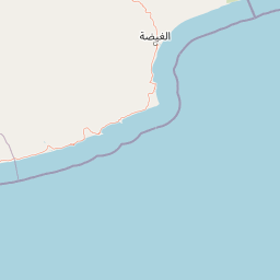
Map view of Hawf National Reserve

Use this park location map to pinpoint Hawf National Reserve in Yemen, understand its exact geographic position, and read its mapped placement within the surrounding landscape more clearly.

Pigeon | © OpenStreetMap contributors
Park atlas

Trace the geographic spread of national reserves and protected landscapes across the Arabian Peninsula.

Explore Other Protected Areas and National Reserves Near Hawf National Reserve

Browse additional national reserves and protected areas located in the surrounding regional context, continuing your geographic discovery from Hawf National Reserve within the Arabian Peninsula. Mapping these conservation landscapes helps users compare park characteristics and understand the broader ecological spread across Yemen and the Eastern Highlands.
Nature reserveDhofar Governorate
About 247 km away#1 closest

Northeast

Jabal Samhan Nature Reserve: Mountain Geography and Protected Area Exploration

Rugged arid terrain in the Dhofar Governorate of southern Oman

Jabal Samhan Nature Reserve represents one of the most significant protected wilderness areas in Oman. Spanning vast escarpments and deep valleys, the reserve acts as a critical mountain habitat that supports a rare community of predators and prey. Explore the geographic boundaries and terrain features that define this remote stronghold within the Dhofar Mountains, a key anchor for conservation in the region.

Area
4,500 km²
Relief
Mountain
Water
Minor water
National parkSomalia
About 703 km away#2 closest

South

Ras Hafun National Park: Somalia's Protected Coastal Landscape and Geographic Atlas Entry

Explore mapped boundaries and regional natural landscapes.

Ras Hafun National Park serves as a focal point for understanding Somalia's protected natural areas and their geographic distribution. As a national park, it offers a distinct landscape entity to analyze within the atlas of the Horn of Africa. This MoriAtlas entry highlights the park's spatial definition and its significance as part of the country's conserved environments, providing essential context for regional geography and mapped terrain exploration.

Area
2,571 km²
Relief
Lowland
Climate
Arid
Access
Access unknown
Protected areaSaudi Arabia
About 826 km away#3 closest

Northwest

'Uruq Bani Ma'arid Protected Area: Saudi Arabian Landscape and Geographic Context

Mapped protected area boundaries and regional geography.

Delve into the specific protected area identity of 'Uruq Bani Ma'arid. This entry provides essential geographic context, detailing its mapped boundaries and its role within the diverse landscape of Saudi Arabia. Understand how this protected land fits into the broader atlas of the Arabian Peninsula, focusing on its unique regional geography and mapped terrain.

Area
12,765 km²
Relief
Mixed relief
Climate
Arid
Access
Highly restricted
Nature reserveAd Dakhiliyah Governorate
About 865 km away#4 closest

Northeast

Jebel Akhdar Mountains Nature Reserve: An Atlas of Oman's High Altitude Protected Landscapes

Geographic analysis of the Ad Dakhiliyah mountain massif

The Jebel Akhdar Mountains represent a critical protected nature reserve defined by dramatic limestone cliffs, deep wadis, and centuries of terraced agriculture. This elevated massif within the Ad Dakhiliyah Governorate sustains a rare montane ecology that serves as a cornerstone of regional Omani geography and environmental conservation.

Established
2011
Relief
Mountain
Climate
Arid
Access
Moderate access
Wildlife reserveOman
About 925 km away#5 closest

Northeast

Al Saleel National Park: A Protected Acacia Forest Wildlife Reserve in Oman

Explore its unique landscape and protected area geography.

Al Saleel National Park in Oman is distinguished by its exceptional acacia forest ecosystem, a scarce habitat type across the Arabian Peninsula. Covering 220 square kilometers, this wildlife reserve serves as a crucial sanctuary for at-risk species like the Arabian gazelle and the endemic Omani wild cat. Its landscape offers a compelling study of arid zone forest ecology and protected area management, providing valuable context for understanding Oman's commitment to natural heritage and conservation within its regional geography.

Area
220 km²
Climate
Arid
Scope
Terrestrial
Water
No major water
Nature reserveDubai
About 951 km away#6 closest

North

Al Marmoom Desert Conservation Reserve: Nature Reserve and Desert Landscape in Dubai

Mapped Geography and Protected Area Context

Explore the Al Marmoom Desert Conservation Reserve, a designated nature reserve located near Dubai. This protected area is crucial for understanding the region's desert geography and landscape. MoriAtlas provides detailed mapping and geographic context, allowing for in-depth study of its protected boundaries and its significance within the UAE's conservation landscape.

Area
0.4 km²
Established
2018
Relief
Lowland
Climate
Arid
Nature reserveDubai
About 958 km away#7 closest

North

Dubai Desert Conservation Reserve: Nature Reserve, Mapped Geography, and Protected Landscape Context

Explore the natural terrain and conservation atlas of this UAE protected area.

This page details the Dubai Desert Conservation Reserve, a designated nature reserve situated within the geographic scope of Dubai, United Arab Emirates. Dive into its mapped boundaries, understand its role as a protected landscape, and gain insight into its unique natural terrain. MoriAtlas provides structured data to explore the park's place within regional geography and the broader atlas of protected areas.

Area
225 km²
Established
2003
Relief
Lowland
Climate
Arid
Nature reserveMuscat Governorate
About 974 km away#8 closest

Northeast

Ad Dimaniyat Islands Nature Reserve: Protected Archipelago and Marine Biodiversity Map

Archipelago landscape and marine protected area in Muscat Governorate.

The Ad Dimaniyat Islands represent a critical nature reserve composed of nine distinct islands in the Gulf of Oman. The archipelago is known for its rare coral formations, nesting beaches for endangered sea turtles, and its role as a breeding site for various seabird species. This protected landscape combines complex underwater reef habitats with rocky and sandy terrain, forming a significant ecological zone within the Muscat Governorate.

Area
1 km²
Relief
Lowland
Access
Moderate access
Scope
Marine

Common questions about visiting, size, designation, and location context for Hawf National Reserve

Hawf National Reserve FAQs for park facts, access, geography, and protected area context

Find quick answers about Hawf National Reserve, including protected-area facts, park geography, trail and visitor context, and how the park fits into its surrounding country and regional landscape.
MoriAtlas Explorer

Continue Your Protected Areas Search Across the Global Atlas

Deepen your exploration by continuing the structured search for national parks and protected areas worldwide. Utilize the comprehensive filtering capabilities to compare different conservation landscapes and refine your understanding of global park geography. Discover more about the distribution and characteristics of protected natural areas.

Global natural geography