Mori Atlas logo
National parkRas Hafun National Park

Explore the mapped boundaries and regional landscape context of this Somali national park.

Ras Hafun National Park: Somalia's Coastal Protected Landscape and National Park Geography

Ras Hafun National Park represents a significant protected area within the Horn of Africa, situated along Somalia's extensive coastline. As a designated national park, it offers a unique lens through which to explore the country's natural geography and mapped protected landscapes. This entry provides detailed atlas-style information, focusing on the park's environmental context and its role in the broader geographic setting of Somalia, inviting a deeper understanding of its protected terrain.

Coastal Protected AreasBird Conservation AreasArchaeological SitesEasternmost Point of AfricaImportant Bird AreasMangrove Ecosystems

Ras Hafun National Park

National park

Park overview

Structured park overview, official facts, and landscape profile for Ras Hafun National Park

Ras Hafun National Park park facts, protected area profile, and essential visitor context

Review the core facts for Ras Hafun National Park, including designation, size, terrain, visitor scale, habitats, and operating context in one park-focused overview.

About Ras Hafun National Park

Ras Hafun National Park protects a landscape of extraordinary geographic and historical significance on Somalia's northeastern coast. The park centers on a prominent peninsula that juts into the Guardafui Channel, marking the easternmost extent of mainland Africa. This dramatic promontory is connected to the mainland by a distinctive sand spit stretching approximately 20 kilometers, creating a natural landform that has guided maritime navigation for centuries. The coastal environment features a mix of rocky shores, sandy beaches, and mangrove ecosystems that provide critical habitat for both marine and terrestrial species. Inland, the landscape transitions into lowland plains supporting an arid savanna with low, woody vegetation, reflecting the semi-arid conditions typical of the Horn of Africa. The park's significance extends beyond its natural values to encompass extraordinary archaeological importance, with the peninsula believed to be the location of ancient Opone, a trading settlement that featured prominently in ancient maritime commerce routes connecting the Roman world, the Persian Gulf, and the Indian Ocean basin.

Quick facts and research context for Ras Hafun National Park

Ras Hafun National Park is situated in the Bari region of Puntland in northeastern Somalia, marking the easternmost tip of mainland Africa where the Guardafui Channel meets the Somali Sea. The park protects a prominent promontory connected to the mainland by a 20-kilometer sand spit, with elevations reaching approximately 5 meters above sea level. The area is recognized as an Important Bird Area by BirdLife International, supporting significant populations of species including the Somali pigeon, Forbes-Watson's swift, and lesser hoopoe-lark. Archaeological evidence confirms the site as the ancient port of Opone, a key node in the Indian Ocean trade network dating to the first century CE. The park has experienced significant natural events in recent decades, including the 2004 Indian Ocean tsunami and Cyclone Gati in 2020.

Protection and recognition

Documenting terrestrial conservation scope and official designated boundaries of the peninsula region

Ras Hafun National Park Official Protection Status and Terrestrial Boundaries

Evaluating the documented protection status of Ras Hafun National Park offers insights into the terrestrial management scope of the coastal peninsula region. Analyzing established terrestrial boundaries provides researchers with essential geographic context on regional conservation frameworks and land management.

Protection details

Protection scope
Terrestrial
Park context

Deeper park guide and search-rich context for Ras Hafun National Park

Ras Hafun National Park history, landscape, wildlife, and travel context

Explore Ras Hafun National Park through its history, landscape character, ecosystems, wildlife, conservation priorities, cultural context, and seasonal travel timing in a structured park guide built for atlas discovery and search intent.

Why Ras Hafun National Park stands out

Ras Hafun National Park is best known for its dual distinction as the easternmost point of mainland Africa and the site of the ancient trade emporium of Opone, one of history's most significant coastal trading cities. The park's dramatic peninsula setting, where the Guardafui Channel meets the Somali Sea, creates a striking geographic landmark visible even from satellite imagery. Its recognition as an Important Bird Area highlights the ecological significance of its coastal and savanna habitats, supporting bird species found nowhere else in the world. The combination of exceptional geographic significance, rich archaeological heritage, and unique biodiversity makes this park one of Somalia's most remarkable protected areas.
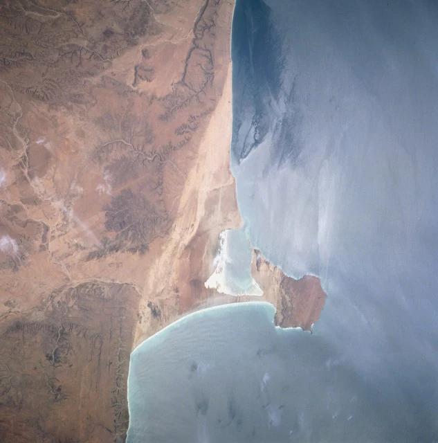
Satellite image of Hafun Peninsula coastline with arid landmass adjacent to the sea
Satellite view of Hafun Peninsula coastline, Somalia, September 1995

Ras Hafun National Park history and protected-area timeline

The history of Ras Hafun stretches back millennia and reflects its strategic position along ancient maritime trade routes. The peninsula is widely identified as the location of Opone, a famous ancient trade emporium mentioned in the Periplus of the Erythraean Sea, a Greek navigational guide written in the first century CE. This document describes Opone as a bustling port city strategically positioned on trade routes spanning the Indian Ocean's rim, where merchants from as far as Indonesia and Malaysia passed through. By 50 CE, the area had already become well established as a center for cinnamon trade, alongside the barter of cloves, other spices, ivory, exotic animal skins, and incense. Archaeological expeditions conducted since the 1970s have uncovered extensive remains including ancient coins, Roman pottery, drystone buildings, cairns, masjids, walled enclosures, standing stones, and platform monuments, with many finds pre-dating the Islamic period. In the pre-independence era, Hafun was governed by the Majeerteen Sultanate and served as the seat of the polity's capital at Alula. The area later formed part of Italian Somaliland. In December 2004, Hafun was struck by the tsunami generated by the Indian Ocean earthquake, representing the most affected area on the African continent. More recently, Cyclone Gati struck directly in November 2020 as the strongest cyclone to hit the Horn of Africa since reliable records began.

Ras Hafun National Park landscape and geographic character

The landscape of Ras Hafun National Park is defined by its dramatic coastal promontory setting where the Guardafui Channel meets the Somali Sea. The peninsula extends from a sand spit that connects to the mainland at the town of Foar, a narrow landform stretching about 20 kilometers long and varying between 1 and 3 kilometers in width. The promontory itself rises to approximately 5 meters above sea level and projects into the ocean, creating a distinctive headland visible from considerable distances. The coastline alternates between rocky sections and sandy beaches, with mangrove stands occurring in sheltered areas where conditions allow. Inland from the coast, the terrain flattens into lowland plains supporting an arid savanna environment characterized by low, woody vegetation adapted to the semi-desert conditions of the Horn of Africa. The combination of the promontory's dramatic geometry, the transition from marine to terrestrial environments, and the stark coastal-to-inland ecological gradient creates a visually striking landscape that has served as a navigational landmark for maritime travelers across centuries.

Ras Hafun National Park ecosystems, habitats, and plant life

The nature of Ras Hafun reflects the meeting point of marine and arid terrestrial ecosystems along Somalia's northeastern coast. The park's coastal zone encompasses rocky shoreline habitats, sandy beach environments, and mangrove stands that provide critical ecological functions despite their relatively limited extent. These coastal ecosystems support marine biodiversity and serve as important feeding and resting areas for various species. Moving inland, the landscape transitions into arid savanna plains characterized by sparse, low woody vegetation adapted to the region's limited rainfall and semi-desert conditions. The park has been designated as an Important Bird Area by BirdLife International due to its significance for bird populations, particularly species with restricted ranges in the Horn of Africa. The unique combination of coastal, mangrove, and arid savanna habitats creates an ecological interface that supports species adapted to both marine-influenced and semi-arid conditions, making the area significant for regional biodiversity despite its harsh climate.

Ras Hafun National Park wildlife and species highlights

Ras Hafun National Park supports notable wildlife populations, with particular significance attributed to its avifauna. The park has been designated as an Important Bird Area by BirdLife International because it supports significant populations of several bird species, including the Somali pigeon, Forbes-Watson's swift, eastern chanting goshawk, Somali fiscal, lesser hoopoe-lark, Somali lark, Somali starling, Somali wheatear, and Somali sparrow. Many of these species are associated with the Horn of Africa region and represent either endemic or near-endemic populations. The arid savanna inland from the coast supports wildlife adapted to semi-desert conditions, while the coastal zone and mangroves provide habitat for marine-influenced species. While specific large mammal information is limited in the source material, the broader Somali ecosystem context suggests the presence of typical arid-land species adapted to the region's climate.

Ras Hafun National Park conservation status and protection priorities

Ras Hafun National Park represents an important conservation designation for Somalia's northeastern coast, protecting both significant natural habitats and extraordinary archaeological heritage. The park's designation as an Important Bird Area by BirdLife International highlights its international conservation significance for supporting populations of regionally endemic bird species. The protection of the coastal-marine interface, including rocky coastlines, sandy beaches, and mangrove ecosystems, preserves critical habitats in a region where such coastal environments face multiple pressures. The park also conserves archaeological sites associated with ancient Opone, one of the most significant trade emporiums in ancient maritime history, representing a cultural heritage dimension that complements its ecological values. The combination of natural and cultural conservation priorities makes this park particularly significant within Somalia's protected area network.

Ras Hafun National Park cultural meaning and human context

Ras Hafun carries profound cultural significance rooted in its role as the ancient port of Opone, one of the most important trading settlements in the Indian Ocean's western basin during classical antiquity. Mentioned in the Periplus of the Erythraean Sea, Opone served as a crucial node in the network of coastal trade emporia that connected the Roman Empire, the Persian Gulf, the Arabian Peninsula, and the Indian subcontinent to Southeast Asian ports. Archaeological evidence reveals centuries of continuous occupation and trade, with materials from ancient Egypt, the Nile Valley, Persia, Mesopotamia, and potentially the Indian subcontinent found at the site. The area also bears the imprint of more recent historical periods, including the era of the Majeerteen Sultanate, with surviving fort structures reflecting the region's political history. Traditional fishing communities continue to inhabit the area, maintaining connections to the sea that have defined local livelihoods for generations. The 17th-century masjids in Hafun represent the Islamic architectural heritage that overlay earlier historical layers.

Top sights and standout views in Ras Hafun National Park

Ras Hafun National Park stands as a unique destination where extraordinary geographic position meets deep historical significance. The park protects mainland Africa's easternmost point, a dramatic peninsula visible from space that has guided sailors for millennia. Visitors and researchers are drawn to the area not only for its geographic distinction but also for its archaeological heritage, as the site of ancient Opone, a legendary trading city where cinnamon, cloves, and other valuable commodities moved between civilizations. The Important Bird Area designation recognizes the park's ecological significance for endemic bird species in a region of global biodiversity importance. The combination of coastal landscapes, archaeological sites, and endemic wildlife creates a compelling conservation narrative for this remote but remarkable corner of Africa.

Best time to visit Ras Hafun National Park

Visiting Ras Hafun National Park would be guided by Somalia's climatic patterns, with the region experiencing arid to semi-arid conditions typical of the Horn of Africa. The coastal position moderates temperatures somewhat compared to inland areas, but conditions remain hot and dry for much of the year. The timing of any visit would need to account for the broader security and accessibility considerations that affect travel to this region of Somalia. The park's significance as a conservation area and archaeological site ensures that visits would be most meaningful during cooler, more comfortable periods, though specific seasonal visitor guidance would depend on current operational conditions and local circumstances.
Monthly climate preview

Trace long-term average temperature and precipitation rhythms across the coordinate point

Ras Hafun National Park Climate Normals and Monthly Temperature Patterns

Representative historical data outlines measured monthly temperature swings alongside low baseline precipitation across the coordinate point in Somalia. Examining twelve distinct monthly climate records provides a complete statistical baseline for research and environmental comparison.
Annual mean27 °C
25 °C29 °C
Jan25°
Feb25°
Mar26°
Apr28°
May29°
Jun29°
Jul28°
Aug27°
Sep27°
Oct27°
Nov27°
Dec26°
Warmest month
May

29.2 °C

Coolest month
January

25.1 °C

Wettest month
November

0.7 mm/day

Driest month
February

0.1 mm/day

Park location guide

Geography guide, regional context, and park location map for Ras Hafun National Park

Ras Hafun National Park park geography, regions, and map view in Somalia

Understand where Ras Hafun National Park sits in Somalia through a broader geographic reading of the surrounding landscape, nearby location context, and its mapped position within the national park landscape.

How Ras Hafun National Park fits into Somalia

Somalia is a federal parliamentary republic located at the easternmost point of continental Africa. Formerly colonised by Britain and Italy, it gained independence in 1960 when British and Italian Somaliland merged. The country has endured prolonged civil conflict since 1991 but has recently stabilised under a federal government. Mogadishu serves as both the capital and largest city.

Wider geography shaping Ras Hafun National Park in Somalia

Somalia occupies the Horn of Africa region, stretching along the eastern coast of the continent. It borders Ethiopia to the west, Djibouti to the northwest, Kenya to the southwest, the Gulf of Aden to the north, and the Indian Ocean to the east. The terrain is predominantly arid plains and plateau, with the Juba and Shabelle rivers in the south.

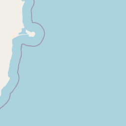
Map view of Ras Hafun National Park

Use this park location map to pinpoint Ras Hafun National Park in Somalia, understand its exact geographic position, and read its mapped placement within the surrounding landscape more clearly.

Pigeon | © OpenStreetMap contributors

Location context for Ras Hafun National Park

Bari

Discover the distinct coastal geography, diverse habitats, and striking protected-area character of this easternmost African landmark.

Ras Hafun National Park Imagery: Coastal Geography, Dramatic Landscapes, and Protected Area Views

The image gallery offers a visual journey through Ras Hafun National Park, showcasing its dramatic coastal promontory, arid savanna, and unique marine-terrestrial interface. Review these photographs to grasp the park's distinctive landscapes, diverse habitats, and its profound geographic and historical significance as Africa's easternmost point and ancient trade hub.

Satellite image of Hafun Peninsula coastline with arid landmass adjacent to the sea

Park atlas

Trace the Geographic Spread of Protected Areas Surrounding Ras Hafun National Park, mapping the diverse coastal and savanna landscapes of the Horn of Africa.

Explore Nearby Protected Areas and Regional Parks Beyond Ras Hafun National Park, Horn of Africa

Browse other national parks and protected landscapes within the geographic region surrounding Ras Hafun National Park, covering coastal promontories, arid savanna, and important bird areas across the Horn of Africa. Comparing these sites reveals the regional spread of marine and terrestrial conservation, deepening understanding of protected area contexts throughout Somalia and the Guardafui Channel.
Nature reserveYemen
About 703 km away#1 closest

North

Hawf National Reserve: Protected Landscape and Mapped Nature Reserve in Yemen

Atlas exploration of Yemen's nature reserve geography.

Hawf National Reserve is a critical protected area within Yemen, recognized for its designation as a nature reserve. This detail page provides an atlas-driven perspective, focusing on the park's mapped boundaries, its unique landscape characteristics within the Arabian Peninsula, and its significance for protected area discovery. Understand the geographic context of Hawf National Reserve and its role in regional conservation through detailed map-based exploration.

Area
300 km²
IUCN
VI
Relief
Mountain
Climate
Tropical
National parkSomalia
About 710 km away#2 closest

West

Ga'an Libah National Park: A National Park's Protected Landscape and Geographic Context

Explore its mapped boundaries and regional geography.

Ga'an Libah National Park, designated as a national park, offers a distinct focus on its protected landscape and geographic identity. This resource details the mapped extent and regional context of the park, contributing to a structured understanding of its natural terrain and protected area significance. Users can explore its specific geography and atlas positioning without travel planning details.

Protected areaSomalia
About 855 km away#3 closest

Southwest

Hobyo National Park Protected Area: Geographic Identity and Mapped Boundaries in Somalia

Exploring protected landscapes and regional terrain.

Hobyo National Park is a protected area contributing to Somalia's conservation landscape. This entry provides essential geographic context, detailing its mapped boundaries and regional significance. Understand its role within East Africa's protected area network and explore its unique terrain through an atlas-driven perspective, focusing on landscape identity and geographic placement.

Scope
Terrestrial
National parkMiddle Juba
About 865 km away#4 closest

Southwest

Jilib National Park: National Park with Mapped Protected Boundaries

Geographic context within Middle Juba.

Examine Jilib National Park as a significant protected natural area. This national park's identity is rooted in its specific geographic location within the Middle Juba region. The atlas-focused presentation details its mapped boundaries and landscape context, allowing for precise exploration of its protected status and regional significance. Understanding Jilib National Park contributes to a broader appreciation of Somalia's conservation geography.

Area
950 km²
Established
1970
IUCN
II
Visitors
300 annual
Nature reserveDhofar Governorate
About 880 km away#5 closest

Northeast

Jabal Samhan Nature Reserve: Mountain Geography and Protected Area Exploration

Rugged arid terrain in the Dhofar Governorate of southern Oman

Jabal Samhan Nature Reserve represents one of the most significant protected wilderness areas in Oman. Spanning vast escarpments and deep valleys, the reserve acts as a critical mountain habitat that supports a rare community of predators and prey. Explore the geographic boundaries and terrain features that define this remote stronghold within the Dhofar Mountains, a key anchor for conservation in the region.

Area
4,500 km²
Relief
Mountain
Water
Minor water
National parkTadjourah Region
About 950 km away#6 closest

West

Day Forest National Park: Ancient Juniper Woodland and Protected Landscape in Djibouti

Discover a rare East African forest refuge with unique endemic species.

Day Forest National Park represents a critical ecological island within Djibouti's predominantly semi-desert geography. As the nation's oldest national park, it protects the largest remaining East African juniper forest, a vital sanctuary for species found nowhere else on Earth. Located in the Goda Mountains of the Tadjourah Region, its existence relies on rare localized rainfall, creating a distinctive mountainous forest environment that offers profound insights into protected landscape dynamics and regional biodiversity.

Area
15 km²
Established
1939
IUCN
II
Relief
Mountain
National parkDjibouti
About 1,009 km away#7 closest

West

Yoboki National Park: Djibouti National Park Geographic Atlas Explorer

Discover its mapped boundaries and regional terrain.

Yoboki National Park is a key protected area within Djibouti, offering a distinct focus for geographic exploration. This entry provides structured information to understand the park's mapped landscape and its position within the Horn of Africa's regional geography. Delve into the park's protected land identity and terrain context, essential for atlas-based discovery and appreciating its natural features.

IUCN
II
Relief
Mixed relief
Climate
Arid
Scope
Terrestrial
National parkAfar Region
About 1,119 km away#8 closest

West

Yangudi Rassa National Park: Protected Semi-Desert National Park in Afar Region

Mapped landscape and dryland ecosystems.

Yangudi Rassa National Park represents a critical protected area within Ethiopia's Afar Region, covering extensive semi-desert and grassland terrains. The park's geography is marked by Mount Yangudi and the broad Rassa Plains, with the Awash River shaping its riverine forests and marshes. This national park offers a unique insight into dryland ecosystems and their conservation, providing a distinct mapped landscape for geographic study and exploration.

Area
4,731 km²
Established
1969
IUCN
II
Relief
Mixed relief

Common questions about visiting, size, designation, and location context for Ras Hafun National Park

Ras Hafun National Park FAQs for park facts, access, geography, and protected area context

Find quick answers about Ras Hafun National Park, including protected-area facts, park geography, trail and visitor context, and how the park fits into its surrounding country and regional landscape.
MoriAtlas Explorer

Continue Your Protected Areas Search Across the Global Atlas

Deepen your exploration by continuing the structured search for national parks and protected areas worldwide. Utilize the comprehensive filtering capabilities to compare different conservation landscapes and refine your understanding of global park geography. Discover more about the distribution and characteristics of protected natural areas.

Global natural geography