

Mori Atlas logo
National parkJilib National Park

Discover the mapped boundaries and geographic context of this national park.

Jilib National Park: Protected National Park Landscape within Middle Juba

Jilib National Park represents a key protected natural area within the Middle Juba region of Somalia. As a designated national park, its mapped boundaries and geographic setting offer valuable insights for atlas-based exploration and understanding regional conservation landscapes. This page provides focused detail on Jilib National Park's place within the broader geographic context, enabling structured discovery of its protected area identity.

National ParkSavannaRiverine ForestWildlife ConservationSomaliaEast Africa

Jilib National Park

National park

Park overview

Structured park overview, official facts, and landscape profile for Jilib National Park

Jilib National Park park facts, protected area profile, and essential visitor context
Review the core facts for Jilib National Park, including designation, size, terrain, visitor scale, habitats, and operating context in one park-focused overview.

About Jilib National Park

Jilib National Park stands as Somalia's premier protected wilderness area, representing the nation's most ambitious effort to preserve its natural heritage. Located in the southern Middle Juba region, the park encompasses approximately 950 square kilometers of diverse habitats ranging from riverine forests along the Jubba River to expansive acacia savanna and seasonal wetlands. The park's establishment in the 1970s marked a pivotal moment in Somalia's environmental policy, as the Siad Barre government sought to develop a sustainable tourism industry centered on the country's unique wildlife. The park lies strategically along the main transportation corridor between Mogadishu and Jilib, positioning it as the most accessible protected area in the country. Despite its significance, the park has faced extraordinary challenges since the outbreak of civil conflict in 1991, which halted all development and severely impacted wildlife populations. Nevertheless, the park's designation as a Category II protected area under IUCN guidelines maintains its formal protection status, and ongoing efforts by diaspora communities from the region continue to advocate for restoration of wildlife tourism and conservation programs. The park's ecological importance extends beyond Somalia's borders, contributing to regional biodiversity conservation in the Horn of Africa.

Quick facts and research context for Jilib National Park

Jilib National Park is situated in the Middle Juba region of southern Somalia, approximately 950 square kilometers in size, making it the country's largest protected area. The park was established in the 1970s during the Siad Barre administration as Somalia's inaugural national park, with the Ministry of Tourism initially driving development of tourism infrastructure in the area. The park lies along the Jubba River valley, with nearby communities including Haranka, Makaso, Geesguud, Galshii-Abiikar, Arbo Abdi, Dhay-Tubako, and Homboy. Visitor numbers peaked at around 300 in 1988 before declining to zero following the start of the Somali Civil War in 1991. The park is governed by the Ministry of Tourism and Wildlife.

Park context

Deeper park guide and search-rich context for Jilib National Park

Jilib National Park history, landscape, wildlife, and travel context
Explore Jilib National Park through its history, landscape character, ecosystems, wildlife, conservation priorities, cultural context, and seasonal travel timing in a structured park guide built for atlas discovery and search intent.

Why Jilib National Park stands out

Jilib National Park is best known as the largest and oldest national park in Somalia, serving as the centerpiece of the country's protected area system. The park is particularly significant for its populations of African bush elephants, African buffalo, and black rhinoceros, all of which have faced severe pressure from poaching and habitat loss. The park also features notable predator diversity, including cheetahs, African wild dogs, spotted hyenas, caracals, and servals. Riverine habitats along the Jubba River support hippopotamus populations and crocodile species, while the savanna woodlands provide crucial habitat for species including aardvarks, aardwolves, warthogs, and diverse reptile fauna. The park represents one of the last strongholds for several threatened species in the Horn of Africa.

Jilib National Park history and protected-area timeline

Jilib National Park was established in the 1970s as the first national park in Somalia, representing a pioneering effort in the country's conservation history. During this period, the Ministry of Tourism under the Siad Barre administration actively worked to center the developing tourist industry around the park, recognizing its potential to showcase Somalia's natural heritage. By 1989, new legislation was drafted to govern the establishment of national parks, game reserves, and special reserves throughout the country, reflecting a maturing approach to protected area management. At this time, wildlife conservation was overseen by the Ministry of Livestock, Forestry and Range's National Range Agency, with a dedicated Department of Wildlife operating an independent law-enforcement unit created through presidential decree. The outbreak of civil war in 1991 brought all development of the national park to an abrupt halt, and visitor numbers dropped to zero as the country descended into instability. Despite these challenges, members of the diaspora from the sheekhaal community of Middle Juba have continued to advocate for the restoration of wildlife tourism in the region, holding conference meetings abroad to explore ways to rebuild the park's conservation and tourism potential.

Jilib National Park landscape and geographic character

Jilib National Park occupies a distinctive position in Somalia's southern landscape, situated within the Jubba River valley region of Middle Juba. The terrain consists primarily of gently undulating savanna plains dominated by acacia woodlands, interspersed with seasonal wetlands and riverine forest corridors along the Jubba River. The park's landscape supports a complex ecological mosaic that transitions from river-dependent habitats near the Jubba to drier savanna uplands further from the watercourse. The region experiences a semi-arid to sub-humid climate typical of southern Somalia, with seasonal rainfall patterns that influence vegetation structure and wildlife distribution throughout the year. The proximity to the Jubba River provides critical water resources that sustain the park's ecosystems during dry seasons, creating important refugia for wildlife and contributing to the area's ecological significance within the broader East African savanna biome.

Jilib National Park ecosystems, habitats, and plant life

The ecosystems within Jilib National Park represent some of the most biologically diverse habitats in Somalia, encompassing a range from riverine forest to savanna woodland. The park's location in the Jubba River valley positions it within a corridor of ecological importance that connects East African ecosystems. Vegetation communities include dense riverine woodlands along watercourses, characterized by fig trees and other evergreen species, transitioning to more open acacia-dominated savanna with scattered baobab trees on higher ground. The seasonal wetlands provide critical habitat for waterfowl and migratory bird species, while also serving as important grazing areas for large herbivores during the wet season. The park's conservation value is enhanced by its role as a refuge for species adapted to both forested and open habitat types, creating a mosaic that supports higher biodiversity than surrounding agricultural and pastoral landscapes.

Jilib National Park wildlife and species highlights

Jilib National Park supports a remarkable diversity of wildlife, with particular significance for several keystone and threatened species. Large mammals include African bush elephants, which numbered over 100 before the onset of civil conflict, African buffalo populations that reached approximately 1,500 individuals, and a small population of black rhinoceros estimated at around 30 individuals in the 1980s. The park supports a diverse carnivore community comprising cheetahs, spotted hyenas, black-backed jackals, honey badgers, caracals, servals, and banded mongooses. The African wild dog was reintroduced to the area in the 1980s after previously disappearing from the region. Other notable mammals include hippopotamus, common warthog, aardvark, aardwolf, African wildcat, African civet, common genet, striped weasel, bat-eared fox, ground pangolin, and crested porcupine. Reptile diversity includes Nile crocodiles, Nile monitors, Jackson's chameleons, African pythons, black mambas, black-necked spitting cobras, and puff adders. Wildlife populations have faced severe pressure from poaching, particularly during the 1980s and following the collapse of central government authority in 1991.

Jilib National Park conservation status and protection priorities

Jilib National Park represents the cornerstone of Somalia's protected area system and holds significant conservation importance for the Horn of Africa region. As the country's largest national park and first established protected area, Jilib serves as a critical refuge for populations of elephants, buffalo, and rhinos that have declined dramatically across Somalia due to poaching and civil conflict. The park's designation as an IUCN Category II protected area provides formal recognition of its national and international conservation significance. Conservation challenges are substantial, including decades of political instability that have prevented effective management, ongoing poaching pressure, and the need for habitat restoration in areas degraded by human activity. The park's location along the Jubba River also positions it within a broader regional conservation context, as the river valley represents a crucial corridor for wildlife movement between protected areas in Kenya and Somalia. Efforts to restore park management and wildlife populations face significant obstacles but remain a priority for both local communities and diaspora stakeholders committed to preserving Somalia's natural heritage.

Jilib National Park cultural meaning and human context

The Jilib National Park region is inhabited by Somali communities whose traditional land-use practices have shaped the landscape over generations. The sheekhaal community of Middle Juba has maintained particular interest in the park's conservation and restoration, with diaspora members actively working to promote wildlife tourism and environmental protection. The park lies near several small towns and villages including Haranka, Makaso, Geesguud, Galshii-Abiikar, Arbo Abdi, Dhay-Tubako, and Homboy, whose residents maintain connections to the land now within the protected area. Traditional pastoral practices in the broader region have influenced the park's boundaries and continue to affect land-use patterns in surrounding areas. The park's establishment in the 1970s represented an effort to balance wildlife conservation with local community needs, though the civil conflict that began in 1991 disrupted these arrangements and complicated relations between conservation goals and community livelihoods.

Top sights and standout views in Jilib National Park

Jilib National Park stands as Somalia's largest and oldest national park, representing the nation's primary protected wilderness area and a critical refuge for elephants, buffalo, and rhinos. The park encompasses approximately 950 square kilometers of diverse habitat in the Jubba River valley, supporting remarkable wildlife diversity including over 30 mammal species and numerous reptiles. Riverine forests along the Jubba River create a distinctive landscape contrast with surrounding savanna, providing crucial water sources and habitat complexity. The park's predator community includes cheetahs, African wild dogs, spotted hyenas, caracals, and servals, while its reptile fauna features Nile crocodiles and several venomous snake species. Historical significance as Somalia's first national park, established in the 1970s, adds cultural value to the park's natural importance. Despite decades of challenges since 1991, the park remains a symbol of Somalia's conservation potential and a focus for restoration efforts by local and diaspora communities.

Best time to visit Jilib National Park

Visiting Jilib National Park is currently not feasible due to the security situation in Somalia following decades of civil conflict. Prior to the outbreak of war in 1991, the optimal time for wildlife viewing would have coincided with the dry season months from December through March, when wildlife congregates around remaining water sources and vegetation is less dense, improving visibility. The short rainy season from April to May and the long rainy season from October to November would have made some areas less accessible but offered opportunities to observe the landscape in its greenest condition. December to February historically represented the peak tourism season, with the 1988 visitor count of 300 suggesting moderate tourism interest during this period. Any future restoration of tourism to the park would need to consider seasonal patterns that balance wildlife viewing opportunities with accessibility and safety considerations.

Park location guide

Geography guide, regional context, and park location map for Jilib National Park

Jilib National Park park geography, regions, and map view in Somalia
Understand where Jilib National Park sits in Somalia through a broader geographic reading of the surrounding landscape, nearby location context, and its mapped position within the national park landscape.

How Jilib National Park fits into Somalia

Somalia is a federal parliamentary republic located at the easternmost point of continental Africa. Formerly colonised by Britain and Italy, it gained independence in 1960 when British and Italian Somaliland merged. The country has endured prolonged civil conflict since 1991 but has recently stabilised under a federal government. Mogadishu serves as both the capital and largest city.

Wider geography shaping Jilib National Park in Somalia

Somalia occupies the Horn of Africa region, stretching along the eastern coast of the continent. It borders Ethiopia to the west, Djibouti to the northwest, Kenya to the southwest, the Gulf of Aden to the north, and the Indian Ocean to the east. The terrain is predominantly arid plains and plateau, with the Juba and Shabelle rivers in the south.

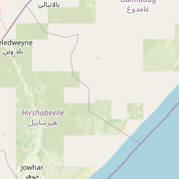
Map view of Jilib National Park

Use this park location map to pinpoint Jilib National Park in Somalia, understand its exact geographic position, and read its mapped placement within the surrounding landscape more clearly.

Pigeon | © OpenStreetMap contributors

Location context for Jilib National Park

Middle Juba
Park atlas

Trace Somalia's protected landscapes and savanna ecosystems, comparing regional park geography around Jilib National Park.

Explore Other National Parks and Protected Areas Near Jilib National Park, Somalia
Continue your protected area discovery beyond Jilib National Park, exploring other national parks and conservation landscapes across Somalia's Middle Juba region. Compare these mapped locations to understand the broader savanna, riverine forest, and wildlife habitats of East Africa's diverse protected zones.
National parkLower Juba

Kismayo National Park: Protected Landscape and National Park Identity in Lower Juba

Explore its mapped geography and regional context.

Gain insight into Kismayo National Park, designated as a National Park in Somalia. This entry provides detailed geographic information, focusing on its mapped protected area boundaries and its placement within the Lower Juba region. It serves as a foundational point for understanding the park's identity as a protected landscape and for atlas-based exploration of Somalia's natural geography.

IUCN
II
Relief
Lowland
Climate
Arid
Scope
Terrestrial
National parkMandera County

Malka Mari National Park: Remote Frontier Protected Landscape and Dawa River Ecosystem

Explore the semi-arid bushland and riparian woodland geography.

Malka Mari National Park offers a profound wilderness experience as Kenya's most remote national park, situated along the Dawa River in Mandera County. This protected area features striking contrasts between arid bushland and verdant riparian woodlands, supporting unique plant species and wildlife adapted to the semi-arid environment. Its vast, undeveloped character makes it a significant site for frontier conservation and a unique destination for atlas-style landscape exploration.

Area
1,500 km²
Established
1989
IUCN
II
Climate
Arid
National parkLower Juba

Lag Badana National Park National Park: Mapped Geography and Protected Landscape Context

Explore the distinct geographic identity of this protected national park.

Lag Badana National Park is a designated national park within the Lower Juba region, offering a focused look at protected landscapes and regional geography. This entry provides an atlas-oriented perspective on the park's mapped boundaries and its significance as a conservation area. Understand its place within the broader geographic context of Somalia through its defined park lands.

Area
3,340 km²
IUCN
II
Climate
Tropical
Scope
Mixed
National parkBale Zone

Bale Mountains National Park National Park: Explore Protected Landscape and Regional Geography

Mapped boundaries and natural terrain context for this Ethiopian park.

Delve into Bale Mountains National Park, a designated national park in Ethiopia's Bale Zone, focusing on its role as a vital protected landscape. This page offers detailed insights into the park's mapped boundaries and its contribution to the regional geography, providing a foundation for structured atlas exploration of protected areas and natural terrain. Understand the geographic significance and landscape identity of this key conservation entity within the broader context of Ethiopia's natural heritage.

Area
2,220 km²
Established
1970
IUCN
II
Relief
Mountain
National parkOromia Region

Borana National Park National Park: Geographic Context and Protected Landscape Atlas

Explore the mapped boundaries and regional geography.

Gain a detailed understanding of Borana National Park, identified as a national park within the Oromia Region of Ethiopia. This entry focuses on its geographic context, providing mapped information crucial for understanding its protected landscape identity. Examine how Borana National Park fits into the broader atlas of conservation areas, offering a precise view of its unique terrain and regional significance without operational details.

Area
45,366 km²
Established
1986
IUCN
II
Relief
Mountain
National parkEthiopia

Awash National Park: Mapped Protected Boundaries and Ethiopian Regional Geography

Discover the protected landscape of this Ethiopian National Park.

Awash National Park represents a significant protected area within Ethiopia, offering a rich focus for geographic discovery. This page illuminates the park's specific mapped boundaries and its positioning within the surrounding regional geography. It serves as a detailed entry point for understanding the park's landscape character and its role as a national park in East Africa.

Area
850 km²
Established
1966
IUCN
II
Relief
Mixed relief
National parkArsi Zone

Arsi Mountains National Park: Protected Ethiopian Highlands Landscape & Geography

Mapped protected terrain and endemic species habitat within the Arsi Zone.

Arsi Mountains National Park is a vast protected area celebrated for its significant biodiversity and distinctive Afro-alpine ecosystems. Situated in the Arsi Zone, this national park encompasses a dramatic mountain landscape central to the Ethiopian Highlands. It serves as a crucial refuge for endangered endemic species, including the mountain nyala and Ethiopian wolf, within its varied ecological zones and protected park boundaries, offering rich context for geographic exploration.

Area
10,876 km²
Established
2011
IUCN
II
Relief
Mountain
National parkTadjourah Region

Day Forest National Park: Ancient Juniper Woodland and Protected Landscape in Djibouti

Discover a rare East African forest refuge with unique endemic species.

Day Forest National Park represents a critical ecological island within Djibouti's predominantly semi-desert geography. As the nation's oldest national park, it protects the largest remaining East African juniper forest, a vital sanctuary for species found nowhere else on Earth. Located in the Goda Mountains of the Tadjourah Region, its existence relies on rare localized rainfall, creating a distinctive mountainous forest environment that offers profound insights into protected landscape dynamics and regional biodiversity.

Area
15 km²
Established
1939
IUCN
II
Relief
Mountain

Common questions about visiting, size, designation, and location context for Jilib National Park

Jilib National Park FAQs for park facts, access, geography, and protected area context
Find quick answers about Jilib National Park, including protected-area facts, park geography, trail and visitor context, and how the park fits into its surrounding country and regional landscape.
MoriAtlas Explorer

Continue Your Protected Areas Search Across the Global Atlas

Deepen your exploration by continuing the structured search for national parks and protected areas worldwide. Utilize the comprehensive filtering capabilities to compare different conservation landscapes and refine your understanding of global park geography. Discover more about the distribution and characteristics of protected natural areas.

Global natural geography
