

Mori Atlas logo
National parkIndwarra National Park

Discover the mapped boundaries and regional geographic context of Indwarra National Park.

Indwarra National Park: New South Wales National Park Geography and Protected Landscape Atlas

Indwarra National Park represents a distinct protected landscape within the geographic framework of New South Wales, Australia. This detail page serves as your primary atlas entry point for understanding its unique identity as a national park. Explore its mapped boundaries and the surrounding natural terrain to gain a comprehensive understanding of its protected area status and its place within the broader regional geography.

strict nature reserveNew England Tablelandsmountain landscapeflora diversityprotected areaNew South Wales

Indwarra National Park

National park

Park overview

Structured park overview, official facts, and landscape profile for Indwarra National Park

Indwarra National Park park facts, protected area profile, and essential visitor context
Review the core facts for Indwarra National Park, including designation, size, terrain, visitor scale, habitats, and operating context in one park-focused overview.

About Indwarra National Park

Indwarra National Park occupies a significant position in the conservation landscape of northern New South Wales as a strict nature reserve. Located on the central New England Tablelands, the park protects a diverse landscape of rolling uplands and mountainous terrain centred around Mount Tingha, which reaches 1208 metres above sea level as the park's highest point. The establishment of the park in January 1999 reflected a growing recognition of the ecological value of the New England Tablelands region, which contains remnants of native vegetation that have been significantly altered in surrounding areas through agricultural development. The strict nature reserve classification places Indwarra among the most stringently protected areas in New South Wales, where conservation of natural processes takes precedence over recreational use. Flora surveys conducted in 2002 documented 220 species of plants within the park boundaries, indicating meaningful biodiversity despite the relatively modest area of the reserve.

Quick facts and research context for Indwarra National Park

Indwarra National Park is a 9 square kilometre strict nature reserve on the New England Tablelands in northern New South Wales. Established in 1999, it protects a mountainous landscape centred on Mount Tingha at 1208 metres. The park supports significant biodiversity with 220 documented flora species recorded during surveys in 2002. The area is classified as IUCN Category Ia, indicating strict protection as a wilderness preserve.

Park context

Deeper park guide and search-rich context for Indwarra National Park

Indwarra National Park history, landscape, wildlife, and travel context
Explore Indwarra National Park through its history, landscape character, ecosystems, wildlife, conservation priorities, cultural context, and seasonal travel timing in a structured park guide built for atlas discovery and search intent.

Why Indwarra National Park stands out

Indwarra National Park is distinguished by its strict nature reserve status, representing a level of protection that limits human access to preserve natural ecological processes. The park is centred on Mount Tingha, the highest and most prominent peak in the reserve, which dominates the mountainous terrain of the central New England Tablelands. The combination of its tabland setting, strict protection designation, and relatively intact native vegetation makes it notable within the New South Wales protected area network.

Indwarra National Park history and protected-area timeline

Indwarra National Park was established in January 1999, creating formal protected area status for this section of the New England Tablelands. The park's creation represented a continuation of efforts throughout the 1990s to expand the network of national parks and nature reserves across New South Wales. Following establishment, systematic flora surveys were conducted in 2002, providing the first comprehensive documentation of the park's botanical resources. These surveys revealed 220 species of flora within the park, establishing a baseline for understanding the ecological character of the reserve. The designation as a strict nature reserve reflected the area's relatively intact natural state and the desire to maintain these conditions with minimal human interference.

Indwarra National Park landscape and geographic character

The landscape of Indwarra National Park is defined by its position on the New England Tablelands, a region of elevated plains and rolling hills in northern New South Wales. Mount Tingha rises prominently within the park, reaching 1208 metres and creating the most visually distinctive feature of the reserve. The terrain supports a variety of slopes and aspects, with vegetation patterns influenced by elevation, soil conditions, and exposure. The tableland setting provides a relatively open landscape character compared to more heavily timbered mountain environments, though native vegetation covers the slopes and ridgelines throughout the park.

Indwarra National Park ecosystems, habitats, and plant life

The ecological character of Indwarra National Park reflects its position on the New England Tablelands, a region that supports distinctive vegetation communities adapted to the cooler, higher-altitude conditions of northern New South Wales. The 220 flora species documented during the 2002 surveys indicate a reasonable diversity for a reserve of this size, though comprehensive faunal surveys are not detailed in available sources. The strict nature reserve designation ensures that natural ecological processes continue with minimal disruption, allowing for the maintenance of native species assemblages and habitat structures. The relatively unmodified condition of the vegetation within the park boundary contrasts with the surrounding landscapes that have been extensively cleared for agricultural purposes.

Indwarra National Park conservation status and protection priorities

Indwarra National Park holds significant conservation value through its strict nature reserve designation, which represents the highest category of protection within the IUCN framework for protected areas. The Category Ia classification indicates that the park is managed primarily for scientific purposes and ecosystem preservation, with access and human activity severely restricted to protect natural values. The New England Tablelands region has experienced substantial land clearing for agriculture and grazing, making the protected areas that remain particularly important for biodiversity conservation. Indwarra serves as a refuge for native species in an otherwise modified landscape, preserving representative examples of tableland ecosystems and the ecological processes that sustain them.

Top sights and standout views in Indwarra National Park

The defining highlight of Indwarra National Park is its status as a strict nature reserve, offering a glimpse of the New England Tablelands landscape in a relatively unmodified state. Mount Tingha provides the park's most prominent natural feature, rising above the surrounding terrain to offer a sense of elevation and openness characteristic of the tablelands. The 220 documented flora species, while modest in absolute terms, represent a valuable collection of native plants in a region where much of the original vegetation has been removed. The park's location on the central New England Tablelands places it within a landscape of significant conservation interest.
Park location guide

Geography guide, regional context, and park location map for Indwarra National Park

Indwarra National Park park geography, regions, and map view in Australia
Understand where Indwarra National Park sits in Australia through a broader geographic reading of the surrounding landscape, nearby location context, and its mapped position within the national park landscape.

How Indwarra National Park fits into Australia

Australia is a constitutional monarchy and federal parliamentary democracy comprising six states and ten territories. With a population of nearly 28 million, it is one of the world's most urbanised countries, with most people concentrated on the eastern seaboard. The country has a high Human Development Index and is known for its cultural diversity, ancient Aboriginal heritage, and unique wildlife.

Wider geography shaping Indwarra National Park in Australia

Australia occupies the entire Australian continent, the island of Tasmania, and numerous smaller islands. It is the world's flattest and driest inhabited continent, featuring vast deserts in the interior (the Outback), tropical rainforests along the eastern coast, and a coastline bordering the Indian and Pacific Oceans.

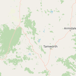
Map view of Indwarra National Park

Use this park location map to pinpoint Indwarra National Park in Australia, understand its exact geographic position, and read its mapped placement within the surrounding landscape more clearly.

Pigeon | © OpenStreetMap contributors

Location context for Indwarra National Park

New South Wales
Park atlas

Explore adjacent protected areas and diverse landscapes across northern New South Wales.

Discover Other National Parks Near Indwarra National Park and the New England Tablelands
Continue your exploration from Indwarra National Park by browsing other protected areas and national parks located throughout the New England Tablelands and broader northern New South Wales. Mapping nearby conservation landscapes allows for direct geographic comparison, revealing regional variations in terrain, protected status, and ecological character.
National parkNew South Wales

Single National Park National Park: A Protected Landscape within New South Wales

Explore mapped boundaries and regional geography.

Single National Park represents a vital protected area, contributing significantly to the natural landscape of New South Wales. This entry offers a deep dive into its geographic scope, detailing mapped park boundaries and the surrounding regional context. It serves as a foundational piece for understanding the park's identity as a protected natural asset and its place within Australia's broader conservation geography.

Area
25.63 km²
Established
1999
IUCN
II
Relief
Mixed relief
National parkNew South Wales

Kings Plains National Park: National Park Protected Area and Geographic Context

Explore mapped boundaries and landscape details for this New South Wales park.

Kings Plains National Park represents a distinct protected area entity within New South Wales, Australia. This national park serves as a focal point for understanding specific geographic features and its mapped boundaries. Users engaging with this park profile can uncover its regional landscape context and explore its significance as part of a larger atlas of protected natural areas. The focus remains on its geographic identity and atlas-based discovery value.

Area
57 km²
Established
1988
IUCN
II
Access
Moderate access
National parkNew South Wales

Warrabah National Park: Discover Protected Landscape and Mapped Geography in New South Wales

Explore the geographic context of this Australian national park.

Warrabah National Park is a designated national park in New South Wales, Australia, offering critical insights into protected area geography. This resource details its mapped boundaries and its place within the region's natural landscape. Understand the park's protected land identity and its contribution to the broader geographical atlas, providing a foundation for focused landscape exploration.

Area
34.71 km²
Established
1984
IUCN
II
Relief
Highland
Watercolor illustration of rolling hills, green forests, and pink flowering trees
National parkNew South Wales

Guy Fawkes River National Park: National Park Geographic Context and Mapped Boundaries

Explore the protected landscape and regional geography of this New South Wales national park.

Gain a structured understanding of Guy Fawkes River National Park, a key national park in New South Wales, Australia. This entry provides detailed insights into its mapped geographic boundaries, its role as a protected landscape, and its contribution to the broader regional context for atlas exploration. Examine the park's place within the natural terrain of New South Wales for a clearer picture of conservation lands.

Area
1,005.9 km²
Established
1972
IUCN
Ib
Relief
Highland
National parkNew South Wales

Butterleaf National Park: National Park Protected Landscape with Regional Geographic Context

Mapped boundaries and terrain within New South Wales.

Butterleaf National Park represents a distinct national park entity within the geographic landscape of New South Wales. This resource provides a focused atlas view, detailing the park's protected boundaries and its specific contribution to the regional terrain. Users can explore the mapped geography and understand the park's identity as a significant protected natural area, offering foundational data for landscape context and conservation analysis.

Area
30 km²
Established
1999
IUCN
II
Scope
Terrestrial
National parkNew South Wales

Barool National Park: National Park Discovery and Geographic Context

Mapped protected area within New South Wales.

Barool National Park is identified as a protected national park, contributing to the rich tapestry of natural landscapes across New South Wales. Understanding its specific location and mapped boundaries is essential for appreciating its role within the regional geography of Australia. This entry provides a factual basis for exploring the park's identity as a defined protected area, offering a unique point of reference for geographic discovery.

Area
112.44 km²
Established
1999
IUCN
II
Climate
Temperate
National parkNew South Wales

Cathedral Rock National Park: New South Wales Protected Landscape and Geography

Explore mapped boundaries and regional natural context.

Delve into Cathedral Rock National Park, a designated national park located in New South Wales, Australia. This detailed view focuses on its protected landscape characteristics, offering insights into its mapped geographic features and its position within the broader regional atlas. Understand the park's terrain and its contribution to the natural landscape context of its location for comprehensive exploration.

Area
89 km²
Established
1978
IUCN
II
Relief
Mountain
National parkNew South Wales

Capoompeta National Park National Park: Protected Landscape and Regional Geography

Explore mapped boundaries and natural terrain in New South Wales.

Capoompeta National Park represents a key protected landscape entity within New South Wales, Australia. This detail page provides focused geographic information, emphasizing its status as a national park and its contribution to the regional atlas. Users can investigate the park's mapped terrain, understand its protected land characteristics, and grasp its geographical setting within the Australian context.

Area
39 km²
Established
1999
IUCN
II
Relief
Mountain

Common questions about visiting, size, designation, and location context for Indwarra National Park

Indwarra National Park FAQs for park facts, access, geography, and protected area context
Find quick answers about Indwarra National Park, including protected-area facts, park geography, trail and visitor context, and how the park fits into its surrounding country and regional landscape.
MoriAtlas Explorer

Continue Your Protected Areas Search Across the Global Atlas

Deepen your exploration by continuing the structured search for national parks and protected areas worldwide. Utilize the comprehensive filtering capabilities to compare different conservation landscapes and refine your understanding of global park geography. Discover more about the distribution and characteristics of protected natural areas.

Global natural geography