Mori Atlas logo
Wildlife reserveIsla de Aves

A low-lying Caribbean coral cay serving as a vital sanctuary for marine wildlife nesting

Isla de Aves Wildlife Reserve: Geographic Boundaries and Regional Protected Landscape Context

(Dependencia Federal de Isla de Aves)

Isla de Aves represents one of the most ecologically significant protected areas in the Caribbean, functioning as an essential nesting site for green sea turtles and seabird colonies. This remote Venezuelan wildlife reserve occupies a fragile sand and coral platform that shifts with regional maritime conditions. Gain insights into the physical landscape, mapped territory, and the distinct geographic role this small island plays within the Federal Dependencies.

Caribbean islandseabird refugesea turtle nestinggreen sea turtlewildlife refugecoral and sand cay

Isla de Aves

Wildlife reserve

Park overview

Structured park overview, official facts, and landscape profile for Isla de Aves

Isla de Aves park facts, protected area profile, and essential visitor context

Review the core facts for Isla de Aves, including designation, size, terrain, visitor scale, habitats, and operating context in one park-focused overview.

About Isla de Aves

Isla de Aves is one of the most unusual protected natural areas in the Caribbean: a few hectares of shifting sand and coral supporting internationally important populations of seabirds and nesting green sea turtles, while also serving as the site of a permanent Venezuelan naval scientific base. Although the island is hardly known in general tourism, it is a focal point of Venezuelan environmental policy and Caribbean maritime geography.

The island lies well north of the Venezuelan mainland and west of the main Lesser Antilles arc, closer to Guadeloupe and Dominica than to any Venezuelan coast. Its remote position has historically made it both ecologically pristine and strategically contested. Administratively, it is a Dependencia Federal, a special status within Venezuela's federal system that places it outside the country's ordinary states and gives it a direct relationship with the central government.

Ecologically, Isla de Aves functions as a concentrated refuge. What it lacks in size, area, and elevation it makes up for in biological productivity during certain seasons, especially when the turtle nesting season brings hundreds of green sea turtle females ashore and when the seabird colonies are at their peak. Because of this outsized ecological role, the island was proclaimed a wildlife refuge by official decree in 1972 and continues to be managed in coordination with the Venezuelan Navy's base on site.

Quick facts and research context for Isla de Aves

Isla de Aves is the northernmost territory administered by Venezuela, lying in the Lesser Antilles region of the Caribbean Sea. It is part of Venezuela's Federal Dependencies, a special administrative category distinct from the country's states, and is constitutionally recognized as part of the national insular territory. The island has been under Venezuelan sovereignty since a 1865 arbitration award, a position later reaffirmed through maritime boundary treaties with the United States, the Netherlands, and France.

The island's geology combines volcanic and coral origins, producing a low sand-and-coral platform that is highly vulnerable to wave action and storm impacts. Despite its small size, Isla de Aves has been officially designated a wildlife refuge since 1972, recognizing its exceptional importance for seabird colonies and nesting sea turtles.

Protection and recognition

Documented conservation scope, designation year, and international recognition details

Isla de Aves Protection Status and Designated History Records

Isla de Aves maintains a recorded protection status established in the 1972 designation history records. Structured management facts track the official protection scope and administrative context for this isolated marine environment.

Protection details

Protection scope
Mixed
Designated year
1972
Transboundary protection
No
Park context

Deeper park guide and search-rich context for Isla de Aves

Isla de Aves history, landscape, wildlife, and travel context

Explore Isla de Aves through its history, landscape character, ecosystems, wildlife, conservation priorities, cultural context, and seasonal travel timing in a structured park guide built for atlas discovery and search intent.

Why Isla de Aves stands out

Isla de Aves is best known as one of the most important nesting sites for the green sea turtle (Chelonia mydas) in the entire Caribbean. Each year, between roughly 350 and 600 female green turtles come ashore mainly from July through September to lay their eggs on the island's sandy beaches, before migrating to feeding grounds as far away as Mexico, Cuba, Puerto Rico, the Dominican Republic, Nicaragua, and other parts of Venezuela. The island is equally renowned for its dense colonies of seabirds that use the sliver of land as a critical roosting and breeding refuge. Together, these concentrations of nesting marine turtles and breeding seabirds on a habitat of only a few hectares give Isla de Aves an outsized ecological significance far greater than its tiny physical footprint would suggest.
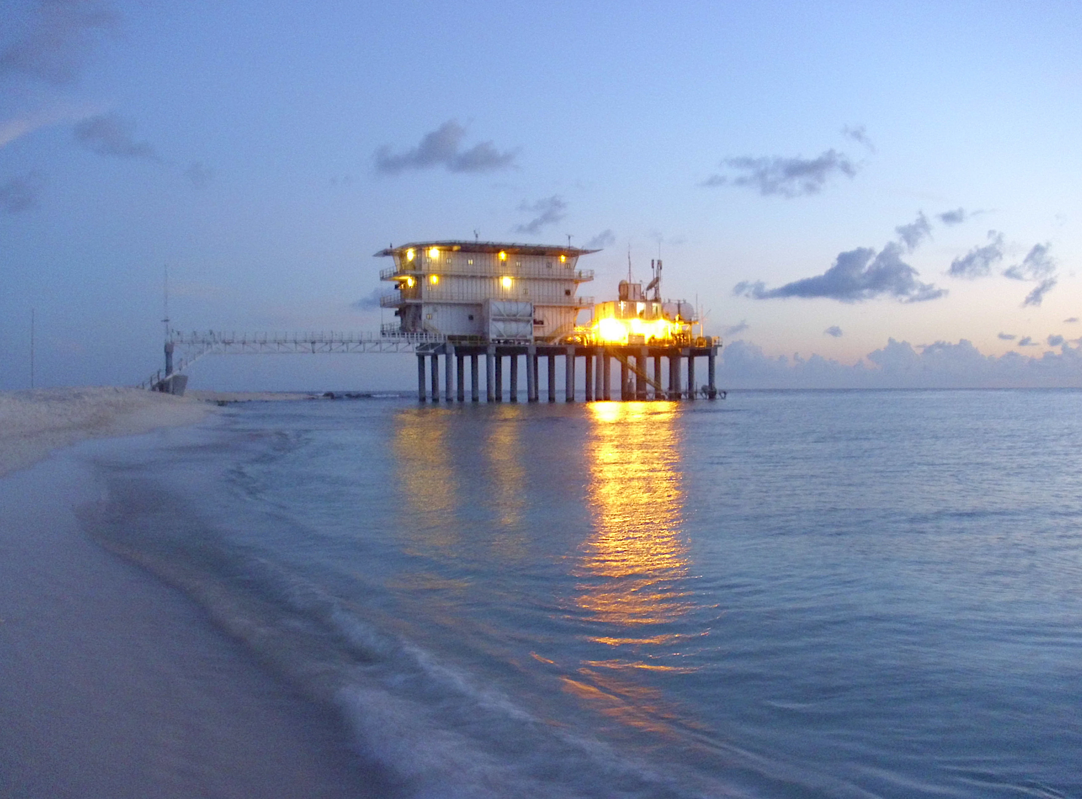
A stilted multi-story structure, identified as the Simon Bolivar Scientific and Naval Base, standing in the shallow coastal waters of Isla de Aves at twilight.
The Simon Bolivar Scientific and Naval Base situated on stilts above the waters of Isla de Aves.

Isla de Aves history and protected-area timeline

Isla de Aves first appears in European cartography in the Padrón Real compiled by Diego Ribero in 1529 and then in Alonso de Santa Cruz's Islario, with early maps showing only its relative position and later ones offering increasingly detailed descriptions of its shape and size. The island was claimed for Spain by Avaro Sanzze in 1584, although it was never permanently settled at that time.

Competing claims were later advanced by Spain, the United Kingdom, Portugal, and the Netherlands. The Dutch pressed their claim from 1854 onward, asserting that the island was connected to the nearby Dutch island of Saba roughly 200 kilometers away; when Venezuela rejected these claims, the Netherlands dispatched a small fleet of three warships to the port of La Guaira in March 1856, accompanied by an ultimatum. The dispute was ultimately resolved through international arbitration, with Queen Isabella II of Spain acting as arbitrator at the request of both countries. On 30 June 1865, the arbitration award confirmed Venezuelan sovereignty over the island.

In July 1895, Venezuelan President Joaquín Crespo organized the country's Caribbean islands and incorporated Isla de Aves into the Territorio Federal Colón. President Cipriano Castro later assigned it to the so-called Municipio Oriental of that territory in May 1905. Between 1878 and 1912, American miners extracted guano from the island until the deposits were exhausted.

The Venezuelan Navy established a permanent military garrison on the island in 1978, naming it Base Científico Naval Simón Bolívar. Hurricane Allen in 1980 split the island into two parts, but subsequent coral growth eventually helped reunify it. On 6 January 1999 the Venezuelan government placed the island under the Dirección de Hidrografía y Navegación, and on 15 December 1999 it was formally included in Article 11 of the Venezuelan Constitution as one of the Federal Dependencies.

Isla de Aves landscape and geographic character

Isla de Aves is essentially a low-lying sand and coral platform sitting at the meeting point of volcanic and coral geological processes. Its highest natural point barely reaches 4 meters above sea level under calm conditions, and during major storms the entire land surface can be temporarily submerged by wave action and surge. The island stretches about 375 meters in length and a maximum of roughly 50 meters across, giving it an elongated, narrow shape oriented through the surrounding Caribbean waters.

The terrain is composed largely of sand with sparse low vegetation and exposed coral material, with no significant elevation, forest cover, or freshwater features. Hurricanes have periodically reshaped the island's outline, most dramatically when Hurricane Allen in 1980 temporarily divided it into two sections that were later rejoined by natural coral growth. The combination of low elevation, narrow footprint, and exposure to open sea gives Isla de Aves one of the most physically fragile landscapes of any protected area in the Caribbean.
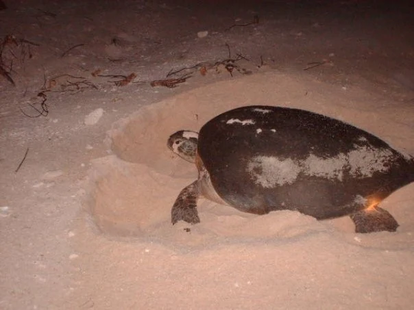
A sea turtle digging in the sand at night, illuminated by a light source.
A sea turtle nesting on the sandy beach of Isla de Aves at night.

Isla de Aves ecosystems, habitats, and plant life

The natural environment of Isla de Aves is shaped by its position as a tiny landmass surrounded by open Caribbean waters, which creates a concentrated interface between marine and terrestrial habitats. Because of its very limited surface and fresh substrate, vegetation is sparse, low, and adapted to salt spray and shifting sand, while the surrounding waters support rich marine life connected to the broader Caribbean ecosystem.

The island's biological value lies less in habitat diversity on land and more in the seasonal intensity of use by marine species. During peak months, Isla de Aves transforms into one of the densest breeding and resting points in the southeastern Caribbean for seabirds, while its beaches become major nesting habitat for sea turtles. This seasonal pulsing of life on a very small platform yields a remarkably high ecological density per hectare compared with much larger protected areas.

Isla de Aves wildlife and species highlights

Isla de Aves supports significant breeding populations of several seabird species that use the island as a refuge for resting and reproduction. The bird colonies are dense enough that the island has historically been known in English as Bird Island or Bird Rock, names that reflect how visibly the avifauna dominates the small land area.

The island is even more notable for its role as a nesting beach for the green sea turtle (Chelonia mydas). Each season, an estimated 350 to 600 female green turtles come ashore mainly between July and September to lay their eggs, making Isla de Aves the most important green sea turtle nesting area in Venezuela and one of the most important in the wider Caribbean. After nesting, the turtles disperse to feeding grounds in countries such as Mexico, Cuba, Puerto Rico, the Dominican Republic, and Nicaragua, and to other Venezuelan islands such as Isla La Tortuga.

Isla de Aves conservation status and protection priorities

Isla de Aves has been a designated wildlife refuge, refugio de fauna silvestre, since Decree No. 1069 of 23 August 1972, which protects its seabird colonies and nesting sea turtles. This early formal protection recognized the island's role as a critical concentration point for marine and avian species despite its extremely limited size.

Conservation management of the island is closely tied to its administrative character as a Federal Dependency and to the presence of the Venezuelan Navy's Base Científico Naval Simón Bolívar, which provides on-site personnel who also support monitoring, scientific observation, and enforcement of wildlife protections. The combination of formal refuge status, continuous human presence, and the island's remoteness has helped maintain the integrity of its seabird and turtle populations, even as the surrounding Caribbean region has faced widespread pressures from overfishing, coastal development, and climate change.

Isla de Aves cultural meaning and human context

Culturally, Isla de Aves has little permanent human community and no traditional settlement, with its only continuous human presence being the small rotation of Venezuelan Navy and scientific personnel at the Simón Bolívar base. The island's name and the informal English names Bird Island and Bird Rock reflect instead how its biological character has shaped external perception more than any local cultural tradition.

In a broader geopolitical sense, the island has been woven into Venezuelan national identity as the northernmost piece of national territory and as a symbol of Caribbean sovereignty, particularly after the 1865 arbitration award and the maritime boundary treaties of 1978 and 1980 that confirmed its status with the United States, the Netherlands, and France.

Top sights and standout views in Isla de Aves

Isla de Aves stands out as one of the smallest but most ecologically intense protected areas in the Caribbean. With only about 4.5 hectares of land, it concentrates globally significant breeding activity for green sea turtles and dense seabird colonies in a habitat barely above sea level.

It is also notable as Venezuela's northernmost territory and as a focal point of Caribbean maritime boundary agreements. The combination of formal wildlife refuge status, an operating scientific naval base, and recognition of Venezuelan sovereignty through multiple international treaties makes Isla de Aves an unusually significant site on both ecological and political maps.

Best time to visit Isla de Aves

Isla de Aves is not a conventional visitor destination and has no tourist infrastructure; access is limited and generally tied to official naval or scientific expeditions. From an ecological perspective, the period from July through September is the most biologically active season on the island, when the majority of green sea turtle nesting occurs and seabird presence is at its peak. Outside this nesting window, the island's terrestrial activity is quieter, although its remote character and stormy exposure can make any visit highly weather-dependent.

Monthly climate preview

Long-term representative temperature and precipitation rhythm across twelve months

Isla de Aves Climate Normals and Monthly Weather Records

Representative coordinates record steady monthly mean temperatures ranging from twenty-six to twenty-nine degrees Celsius alongside varying daily precipitation rates. Opening the full twelve-month profile provides complete historical averages for evaluating long-term environmental patterns.
Annual mean27 °C
26 °C29 °C
Jan26°
Feb26°
Mar26°
Apr27°
May27°
Jun28°
Jul28°
Aug28°
Sep29°
Oct28°
Nov28°
Dec27°
Warmest month
September

28.5 °C

Coolest month
February

26 °C

Wettest month
September

2.6 mm/day

Driest month
February

0.5 mm/day

Park location guide

Geography guide, regional context, and park location map for Isla de Aves

Isla de Aves park geography, regions, and map view in Venezuela

Understand where Isla de Aves sits in Venezuela through a broader geographic reading of the surrounding landscape, nearby location context, and its mapped position within the national park landscape.

How Isla de Aves fits into Venezuela

Venezuela is a country in northern South America with coastline along the Caribbean Sea and Atlantic Ocean. It borders Colombia, Brazil, Guyana, and Trinidad and Tobago. The country has an area of approximately 916,445 km² and a population of about 31.8 million. Caracas is the capital and largest city. Venezuela consists of 23 states and the Capital District.

Wider geography shaping Isla de Aves in Venezuela

Venezuela is located on the northern coast of South America. The continental territory is bordered by the Caribbean Sea and Atlantic Ocean to the north, Colombia to the west, Brazil to the south, and Guyana to the east. Trinidad and Tobago lies to the northeast. The country includes various islands and islets in the Caribbean Sea known as the Federal Dependencies.

Map view of Isla de Aves

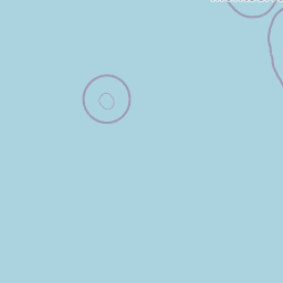
Use this park location map to pinpoint Isla de Aves in Venezuela, understand its exact geographic position, and read its mapped placement within the surrounding landscape more clearly.

Pigeon | © OpenStreetMap contributors

Location context for Isla de Aves

Federal Dependencies

Visualizing remote Caribbean terrain, fragile coral sand cays, and critical marine habitats

Isla de Aves Photos and Protected Landscape Scenery

Photographic collections reveal the isolated terrain, low elevation sand cays, and marine habitats that define the protected area. Examining visual records helps observers understand the fragile coastal environment and wildlife refuges characterizing the remote Caribbean sanctuary.

A stilted multi-story structure, identified as the Simon Bolivar Scientific and Naval Base, standing in the shallow coastal waters of Isla de Aves at twilight.

An aerial view showing a narrow, crescent-shaped sandy island surrounded by clear turquoise and deep blue ocean waters.

A sea turtle digging in the sand at night, illuminated by a light source.

Park atlas

Compare surrounding marine reserves and island sanctuaries across the region

Exploring Protected Areas Near Isla de Aves and Regional Caribbean Parks

Browse other protected areas near Isla de Aves to examine connected marine habitats and regional marine conservation networks. Regional park comparison reveals broader ecological patterns across remote Caribbean island ecosystems.
Marine protected areaFrance
About 86 km away#1 closest

East

Sanctuaire Agoa: Exploring the Marine Protected Landscapes of the French Antilles

Regional marine mammal sanctuary and Caribbean oceanic geography

Sanctuaire Agoa represents a significant marine protected area spanning 143,000 square kilometers across the Caribbean. The sanctuary provides vital protection for humpback whales, dolphins, and various marine mammals while serving as a hub for regional cooperation in the Lesser Antilles. Mapping the sanctuary reveals a complex maritime space that stretches from shallow reef-fringed volcanic islands to deep ocean pelagic waters.

Area
143,256 km²
Established
2010
Climate
Tropical
Access
Access unknown
Watercolor painting of mountains, a lake, and green hills
National parkGuadeloupe
About 201 km away#2 closest

East

Guadeloupe National Park: Volcanic Rainforest and Protected Landscape Identity

Explore mapped boundaries and regional geography.

Guadeloupe National Park stands as a significant protected landscape, primarily defined by the dramatic volcanic terrain of Basse-Terre. This atlas entry focuses on the park's vital role in preserving one of the Caribbean's most extensive tropical rainforest ecosystems, centered around the active La Soufrière volcano. Understand its mapped boundaries, unique geographic setting within the Lesser Antilles, and its importance as a national park and UNESCO biosphere reserve.

Area
173 km²
Established
1989
IUCN
II
Relief
Mountain
Marine protected areaSint Eustatius
About 209 km away#3 closest

North

Sint Eustatius National Marine Park: Protected Marine Geography and Atlas

Volcanic foundations, shipwreck reefs, and marine conservation zones

Sint Eustatius National Marine Park protects a diverse Caribbean marine ecosystem defined by its volcanic origins. The area features reefs growing on submerged lava flows and colonial shipwrecks, integrated with designated no-take reserves that safeguard critical sea turtle nesting sites and migratory corridors for cetaceans.

Area
27.5 km²
Established
1996
Climate
Tropical
Access
Access unknown
National parkDominica
About 231 km away#4 closest

East

Cabrits National Park: Protected Landscape and Geographic Context in Dominica

Explore Dominica's volcanic terrain and mapped protected areas.

Delve into the protected landscape of Cabrits National Park, a key component of Dominica's natural heritage. This entry provides an atlas-focused view of the park, detailing its geographic setting and mapped boundaries within the island nation. Understand how Cabrits National Park contributes to the regional geography of the Lesser Antilles and appreciate its significance as a protected natural area for structured discovery.

Area
5.3 km²
Established
1986
IUCN
II
Relief
Upland
National parkDominica
About 239 km away#5 closest

East

Morne Diablotin National Park: Dominica National Park Geographic Atlas Exploration

Mapped protected areas and regional landscape context.

Morne Diablotin National Park serves as a vital national park within Dominica, offering specific insights into its protected terrain and geographic setting. Explore its mapped boundaries and understand its role as a distinct natural landscape within the island's atlas, providing focused discovery for those interested in protected areas and their regional context.

Area
33.35 km²
Established
2000
Relief
Mountain
Climate
Tropical
National parkAntigua and Barbuda
About 245 km away#6 closest

Northeast

Green Castle Hill National Park: Volcanic Landscapes and Archaeological Sites in Antigua

A preserved hilltop ridge within the Shekerley Mountains of Antigua.

Green Castle Hill preserves a significant volcanic landscape in the southwest of Antigua. Renowned for its circle of ancient standing stones and its status as the first national park within the Shekerley range, the site offers a unique intersection of cultural heritage and mountain geography. Access map-driven insights into the protected boundaries and regional terrain that define this Caribbean hilltop.

Established
2008
Relief
Mountain
Climate
Tropical
Scope
Terrestrial
Protected areaAntigua and Barbuda
About 246 km away#7 closest

Northeast

Fort Barrington Protected Area: Historic Coastal Ruins and Mapping in Antigua and Barbuda

Coastal hilltop ruins and strategic Caribbean maritime defense geography

Fort Barrington occupies a commanding vantage point above St. John's Harbour in Antigua and Barbuda. The site preserves stone ruins from an 18th century battery, illustrating the strategic importance of this elevated coastal landscape. Our data mapping highlights the fort's relationship to the harbor entrance, providing clear context for its role in colonial maritime defense and its ongoing environmental exposure within the Lesser Antilles.

Established
1779
Relief
Upland
Access
Easy access
Scope
Terrestrial
National parkDominica
About 246 km away#8 closest

East

Morne Trois Pitons National Park: Dominica's Volcanic Protected Area Atlas

Explore its unique geothermal terrain and mapped natural boundaries.

Morne Trois Pitons National Park represents a core protected area within Dominica, renowned for its dramatic volcanic landscapes and rich geothermal activity. This national park features steep volcanic cones, deep canyons, and diverse terrain shaped by intense geological forces. The park's mapped boundaries encompass unique natural wonders, offering a focused study of volcanic geography and protected ecosystems. Discover the contours of this significant Caribbean landscape and its inherent natural value.

Area
68.57 km²
Established
1975
IUCN
II
Relief
Mountain

Common questions about visiting, size, designation, and location context for Isla de Aves

Isla de Aves FAQs for park facts, access, geography, and protected area context

Find quick answers about Isla de Aves, including protected-area facts, park geography, trail and visitor context, and how the park fits into its surrounding country and regional landscape.
MoriAtlas Explorer

Continue Your Protected Areas Search Across the Global Atlas

Deepen your exploration by continuing the structured search for national parks and protected areas worldwide. Utilize the comprehensive filtering capabilities to compare different conservation landscapes and refine your understanding of global park geography. Discover more about the distribution and characteristics of protected natural areas.

Global natural geography